The National Road was the first major improved highway in the United States built by the federal government. Built between 1811 and 1837, the 620-mile (1,000 km) road connected the Potomac and Ohio Rivers and was a main transport path to the West for thousands of settlers. When improved in the 1830s, it became the second U.S. road surfaced with the macadam process pioneered by Scotsman John Loudon McAdam.
Ohio County is a county located in the Northern Panhandle of the U.S. state of West Virginia. As of the 2020 census, the population was 42,425. Its county seat is Wheeling. The county was formed in 1776 from the District of West Augusta, Virginia. It was named for the Ohio River, which forms its western boundary with the state of Ohio. West Liberty was designated as the county seat in 1777, serving to 1797.

Marshall County is a county in the U.S. state of West Virginia. At the 2020 census, the population was 30,591. Its county seat is Moundsville. With its southern border at what would be a continuation of the Mason-Dixon line to the Ohio River, it forms the base of the Northern Panhandle of West Virginia.
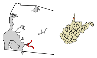
Triadelphia is a town in Ohio County, West Virginia, United States. It is part of the Wheeling, West Virginia Metropolitan Statistical Area. The population was 669 at the 2020 census.

Wheeling is a city in the U.S. state of West Virginia. Located almost entirely in Ohio County, of which it is the county seat, it lies along the Ohio River in the foothills of the Appalachian Mountains and also contains a tiny portion extending into Marshall County. Wheeling is located about 60 miles (96 km) west of Pittsburgh and is the principal city of the Wheeling metropolitan area. As of the 2020 census, the city had a population of 27,062, and the metro area had a population of 139,513. It is the fifth-largest city in West Virginia, and the largest in the state’s Northern Panhandle.
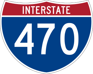
Interstate 470 (I-470) is a 10.63-mile-long (17.11 km) auxiliary Interstate Highway of I-70 that bypasses the city of Wheeling, West Virginia, United States. I-470 is one of 13 auxiliary Interstate Highways in Ohio and the only auxiliary Interstate Highway in West Virginia. The western terminus of I-470 is an interchange with I-70 in Richland Township, Ohio. Traveling southeast through rural Belmont County, I-470 approaches the Vietnam Veterans Memorial Bridge, which spans the Ohio River. After crossing the river into Ohio County, West Virginia, the highway continues east toward the Wheeling communities of Bethlehem and Elm Grove and its eastern terminus at I-70 near Elm Grove. The portion of the highway in West Virginia is named the USS West Virginia Memorial Highway by proclamation of then-Governor Cecil H. Underwood on the 59th anniversary of the attack on Pearl Harbor.

The West Virginia State Capitol is the seat of government for the U.S. state of West Virginia, and houses the West Virginia Legislature and the office of the Governor of West Virginia. Located in Charleston, West Virginia, the building was dedicated in 1932. Along with the West Virginia Executive Mansion it is part of the West Virginia Capitol Complex, a historic district listed on the National Register of Historic Places.
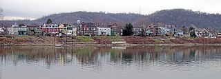
Wheeling Island is the most populated island in the Ohio River. It lies within the city of Wheeling in Ohio County, West Virginia, in the United States. The 2000 census showed a resident population of 3,142 people on the island, which has a land area of 1.514 square kilometres. Neville Island, Pennsylvania, is larger but has fewer people (1,232).
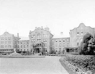
Mount de Chantal Visitation Academy was a private Catholic all-girls school in the city of Wheeling in the U.S. state of West Virginia.

Shepherd Hall, also known as Monument Place and formerly as Stone Mansion, is a historic house listed on the National Register of Historic Places in the city of Wheeling in the U.S. state of West Virginia. It is located in the Elm Grove area of Wheeling, Ohio County, West Virginia.
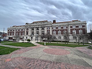
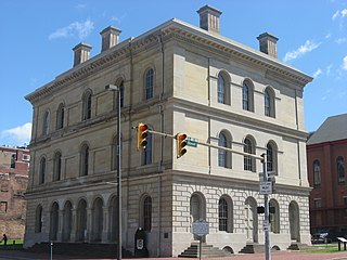
Wheeling station is a U.S. historic train station located at Wheeling, Ohio County, West Virginia. It was built in 1907–1908, and is a four-story, rectangular brick and limestone building in the Beaux-Arts-style. It measures 250 feet long by 89 feet, 6 inches, deep. It features mansard roofs, built of concrete and covered with Spanish tile painted pink. Passenger service ceased in 1961. The building was remodeled in 1976 to house the West Virginia Northern Community College.
The Wheeling, WV-OH Metropolitan Statistical Area, as defined by the United States Census Bureau, is an area consisting of two counties in the Northern Panhandle of West Virginia and one in eastern Ohio, anchored by the city of Wheeling. As of the 2010 census, the MSA had a population of 147,950. This represents a decline of 3.4% from the 2000 census population of 153,172.

Stone Tavern at Roney's Point is a historic inn and tavern complex located at Roney's Point, Ohio County, West Virginia. It includes an early 19th-century stone tavern and early 20th-century auto camp. The tavern is Federal in style, having an I house form, with later Italianate details added in the 1870s. It is built of sandstone and a two-story brick wing was added in the 1920s. The auto court, known as the Stone House Auto Court, was built in 1922. The remaining building is one story, with 10 units and a lower level garage. It is built of square tile block and coated in stucco.
Lawford is an unincorporated community in Ritchie County, in the U.S. state of West Virginia.
Marlow Run is a 1.42 mi (2.29 km) long 1st order tributary to Middle Wheeling Creek in Ohio County, West Virginia.
Orrs Run is a 1.75 mi (2.82 km) long 2nd order tributary to Middle Wheeling Creek in Ohio County, West Virginia. This is the only stream of this name in the United States.
Gashell Run is a 2.02 mi (3.25 km) long 1st order tributary to Little Wheeling Creek in Ohio County, West Virginia. This is the only stream of this name in the United States.
Roneys Point Run is a 2.17 mi (3.49 km) long 1st order tributary to Little Wheeling Creek in Ohio County, West Virginia. This is the only stream of this name in the United States.
Point Run is a 2.08 mi (3.35 km) long 1st order tributary to Little Wheeling Creek in Ohio County, West Virginia.