Masontown, West Virginia

Last updated

Masontown, West Virginia
Ralphsnyder Decagonal Barn.jpg
Preston County West Virginia Incorporated and Unincorporated areas Masontown Highlighted.svg
Location of Masontown in Preston County, West Virginia.
Coordinates: 39°33′7″N79°48′1″W / 39.55194°N 79.80028°W / 39.55194; -79.80028
Country United States
State West Virginia
County Preston
Incorporated 1905 [1]
Area
[2]
  Total0.28 sq mi (0.72 km2)
  Land0.28 sq mi (0.72 km2)
  Water0.00 sq mi (0.00 km2)
Elevation
[3]
1,801 ft (549 m)
Population
 (2020) [4]
  Total510
  Estimate 
(2021) [4]
533
  Density1,935.25/sq mi (746.97/km2)
Time zone UTC-5 (Eastern (EST))
  Summer (DST) UTC-4 (EDT)
ZIP code
26542
Area code 304
FIPS code 54-52228 [5]
GNIS feature ID1555063 [3]
Website local.wv.gov/masontown/Pages/default.aspx

Masontown is a town in western Preston County, West Virginia, United States. The population was 510 at the 2020 census. [6] It is part of the Morgantown metropolitan area.

Contents

History

Masontown was laid out and platted in 1856. [7] The town was named after William Mason, a pioneer merchant. [8]

Located near Masontown is the Ralphsynder Decagonal Barn, listed on the National Register of Historic Places in 1985. [9]

Geography

Masontown is located at 39°33′7″N79°48′1″W / 39.55194°N 79.80028°W / 39.55194; -79.80028 (39.551821, -79.800156). [10] It has also been host to the All Good Music Festival for the past few years.

According to the United States Census Bureau, the town has a total area of 0.28 square miles (0.73 km2), all land. [11]

Demographics

Historical population
CensusPop.Note
1910 520
1920 83159.8%
1930 92411.2%
1940 869−6.0%
1950 9418.3%
1960 841−10.6%
1970 8683.2%
1980 1,05221.2%
1990 737−29.9%
2000 647−12.2%
2010 546−15.6%
2020 510−6.6%
2021 (est.)533 [4] 4.5%
U.S. Decennial Census [12]

2010 census

At the 2010 census there were 546 people, 255 households, and 149 families living in the town. The population density was 1,950.0 inhabitants per square mile (752.9/km2). There were 311 housing units at an average density of 1,110.7 per square mile (428.8/km2). The racial makeup of the town was 98.5% White, 0.5% Pacific Islander, and 0.9% from two or more races. Hispanic or Latino of any race were 0.4%. [13]

Of the 255 households 21.6% had children under the age of 18 living with them, 43.1% were married couples living together, 9.4% had a female householder with no husband present, 5.9% had a male householder with no wife present, and 41.6% were non-families. 34.5% of households were one person and 12.1% were one person aged 65 or older. The average household size was 2.14 and the average family size was 2.70.

The median age in the town was 42.5 years. 17.6% of residents were under the age of 18; 6.2% were between the ages of 18 and 24; 30.3% were from 25 to 44; 27% were from 45 to 64; and 19% were 65 or older. The gender makeup of the town was 48.7% male and 51.3% female.

2000 census

At the 2000 census there were 647 people, 280 households, and 180 families living in the town. The population density was 2,299.2 inhabitants per square mile (892.2/km2). There were 339 housing units at an average density of 1,204.7 per square mile (467.5/km2). The racial makeup of the town was 99.07% White, 0.15% African American, and 0.77% from two or more races. Hispanic or Latino of any race were 2.32%. [5]

Of the 280 households 23.6% had children under the age of 18 living with them, 50.7% were married couples living together, 9.6% had a female householder with no husband present, and 35.4% were non-families. 30.7% of households were one person and 18.9% were one person aged 65 or older. The average household size was 2.31 and the average family size was 2.83.

The age distribution was 20.6% under the age of 18, 8.0% from 18 to 24, 27.5% from 25 to 44, 23.2% from 45 to 64, and 20.7% 65 or older. The median age was 42 years. For every 100 females, there were 88.1 males. For every 100 females age 18 and over, there were 91.1 males.

The median household income was $22,750 and the median family income was $29,886. Males had a median income of $24,219 versus $21,250 for females. The per capita income for the town was $12,927. About 17.0% of families and 20.9% of the population were below the poverty line, including 40.2% of those under age 18 and 9.0% of those age 65 or over.

Education

West Preston Middle School is a small middle school located in Masontown, West Virginia, and consists of two main buildings. As of 2012, the school is 95 years old. The current principal is James Hoit. In 2015, a new middle school will be built, as the levy held in 2010 gave permission to go ahead. The school was founded in 1918, by citizens of Masontown selling pies. This school was built as Masontown High School and later consolidated with Arthurdale High School to become Valley High School, and consisted of the main building with three stories. Later, the second building was built. This was at first an elementary school, but later was combined with West Preston School to form one big high school. Later, after the construction of Preston High School, it was made into a middle school. [14]

Related Research Articles

<span class="mw-page-title-main">Preston County, West Virginia</span> County in West Virginia, United States

Preston County is a county located in the U.S. state of West Virginia. As of the 2020 Census, the population was 34,216. Its county seat is Kingwood. The county was formed from Monongalia County in 1818 and named for Virginia Governor James Patton Preston.

<span class="mw-page-title-main">Calumet, Iowa</span> City in Iowa, United States

Calumet is a city in O'Brien County, Iowa, United States. The population was 146 at the 2020 census.

<span class="mw-page-title-main">Standish, Maine</span> Town in the state of Maine, United States

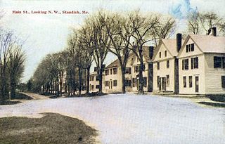
Standish is a town in Cumberland County, Maine, United States. The population was 10,244 at the 2020 census. It includes the villages of Standish Corner, Sebago Lake Village and Steep Falls, and the localities known as Richville, Elmwood, Standish Neck and Two Trails. Standish is part of the Portland-South Portland-Biddeford, Maine metropolitan statistical area.

<span class="mw-page-title-main">Wright, New York</span> Town in New York, United States

Wright is a town in Schoharie County, New York, United States. The population was 1,516 at the 2020 census. The town was named after governor Silas Wright.

<span class="mw-page-title-main">Masontown, Pennsylvania</span> Borough in Pennsylvania, United States

Masontown is a borough in Fayette County, Pennsylvania, United States. It is part of the Pittsburgh Metro Area. The population of the borough was 3,274 at the 2020 census. It is served by the Albert Gallatin Area School District. Masontown is a small crossroads for the rural portions of western Fayette County, and it contains a small shopping center and a grocery store within its business district.

<span class="mw-page-title-main">Bradshaw, West Virginia</span> Town in West Virginia, United States

Bradshaw is a town in McDowell County, West Virginia, United States. The population was 337 at the 2010 census. Bradshaw was incorporated in December 1979 and named for a pioneer settler.

<span class="mw-page-title-main">Elk Garden, West Virginia</span> Town in West Virginia, United States

Elk Garden is a town in Mineral County, West Virginia, United States. It is part of the 'Cumberland, MD-WV Metropolitan Statistical Area'. The population was 211 at the 2020 census. Elk Garden High School was consolidated into Keyser High School in 1997. However the Primary School is still in session, offering classes from Pre-Kindergarten through the fifth grade. The school mascot is the Elk Garden Stags. Elk Garden was incorporated in 1890 by the Mineral County Circuit Court. It is named for an elk lick near the original town site.

<span class="mw-page-title-main">Albright, West Virginia</span> Town in West Virginia, United States

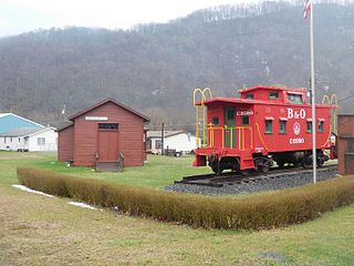
Albright is a town in central Preston County, West Virginia, United States, along the Cheat River. The population was 260 at the 2020 census. A former coal town, it is part of the Morgantown metropolitan area.

<span class="mw-page-title-main">Brandonville, West Virginia</span> Town in West Virginia, United States

Brandonville is a town in northern Preston County, West Virginia, United States. The population was 136 at the 2020 census. It is part of the Morgantown metropolitan area.

<span class="mw-page-title-main">Bruceton Mills, West Virginia</span> Town in West Virginia, United States

Bruceton Mills is a town in northern Preston County, West Virginia, United States, along Big Sandy Creek. The population was 64 at the 2020 census, making it the second-least populous town in West Virginia, after Thurmond. It is part of the Morgantown metropolitan area.

<span class="mw-page-title-main">Kingwood, West Virginia</span> City in West Virginia, United States

Kingwood is a city in and the county seat of Preston County, West Virginia, United States. The population was 2,980 at the 2020 census. The city sits within the Allegheny Mountains above the Cheat River valley. It is part of the Morgantown metropolitan area.

<span class="mw-page-title-main">Newburg, West Virginia</span> Town in West Virginia, United States

Newburg is a town in western Preston County, West Virginia, United States. The population was 275 at the 2020 census. It is part of the Morgantown metropolitan area.

<span class="mw-page-title-main">Reedsville, West Virginia</span> Town in West Virginia, United States

Reedsville is a town in western Preston County, West Virginia, United States. The population was 530 at the 2020 census. It is part of the Morgantown metropolitan area.

<span class="mw-page-title-main">Rowlesburg, West Virginia</span> Town in West Virginia, United States

Rowlesburg is a town in southern Preston County, West Virginia, United States, along the Cheat River. The population was 438 at the 2020 census. It is part of the Morgantown metropolitan area. A former railroad town, it is home to the Downtown Rowlesburg Historic District, and was the site of action during the American Civil War.

<span class="mw-page-title-main">Terra Alta, West Virginia</span> Town in West Virginia, United States

Terra Alta is a town in eastern Preston County, West Virginia, United States. The population was 1,415 at the 2020 census. It is part of the Morgantown metropolitan area.

<span class="mw-page-title-main">Tunnelton, West Virginia</span> Town in West Virginia, United States

Tunnelton is a town in southwestern Preston County, West Virginia, United States. The population was 307 at the 2020 census. It is part of the Morgantown metropolitan area.

<span class="mw-page-title-main">Mill Creek, West Virginia</span> Town in West Virginia, United States

Mill Creek is a town in Randolph County, West Virginia, United States, along the Tygart Valley River. The population was 563 at the 2020 census.

<span class="mw-page-title-main">Flemington, West Virginia</span> Town in West Virginia, United States

Flemington is a town in Taylor County, West Virginia, United States. The population was 311 at the 2020 census. Flemington was incorporated in 1922 by the West Virginia Circuit Court, and named for James Fleming, an early settler in the area originally from Hampshire County.

<span class="mw-page-title-main">Hambleton, West Virginia</span> Town in West Virginia, United States

Hambleton is a town in Tucker County, West Virginia, United States. The population was 216 at the 2020 census. Hambleton was established in 1889, but not incorporated until 1905. It was named by then United States Senator Stephen B. Elkins in honor of a stockholder by this name in the West Virginia Central Railroad Company. The town was previously known as Hulings.

Hazel Green is a town in Grant County, Wisconsin, United States. The population was 1,043 at the 2000 census. The Village of Hazel Green is located partially within the town. The unincorporated community of Prairie Corners is located in the town. The unincorporated community of Sinsinawa, Wisconsin, is also located partially in the town.

References

  1. "About Us" . Retrieved August 2, 2023.
  2. "2019 U.S. Gazetteer Files". United States Census Bureau. Retrieved August 7, 2020.
  3. 1 2 U.S. Geological Survey Geographic Names Information System: Masontown, West Virginia
  4. 1 2 3 "City and Town Population Totals: 2020-2021". Census.gov. US Census Bureau. Retrieved July 3, 2022.
  5. 1 2 "U.S. Census website". United States Census Bureau . Retrieved January 31, 2008.
  6. "U.S. Census website". United States Census Bureau . Retrieved December 2, 2022.
  7. Morton, Oren Frederic; Cole, J. R. (1914). A History of Preston County, West Virginia. Journal Publishing Company. p. 273.
  8. Kenny, Hamill (1945). West Virginia Place Names: Their Origin and Meaning, Including the Nomenclature of the Streams and Mountains. Piedmont, WV: The Place Name Press. p. 405.
  9. "National Register Information System". National Register of Historic Places . National Park Service. July 9, 2010.
  10. "US Gazetteer files: 2010, 2000, and 1990". United States Census Bureau. February 12, 2011. Retrieved April 23, 2011.
  11. "US Gazetteer files 2010". United States Census Bureau. Archived from the original on February 20, 2011. Retrieved January 24, 2013.
  12. "Census of Population and Housing". Census.gov. Retrieved June 4, 2015.
  13. "U.S. Census website". United States Census Bureau . Retrieved January 24, 2013.
  14. West Preston Middle School