Ronceverte, West Virginia

Last updated

Ronceverte, West Virginia
Ronceverte WV Depot - Street View.jpg
Ronceverte Depot, April 2009
Seal of Ronceverte, West Virginia.png
Nickname: 
The Friendly River City
Greenbrier County West Virginia Incorporated and Unincorporated areas Ronceverte Highlighted.svg
Location of Ronceverte in Greenbrier County, West Virginia.
Coordinates: 37°44′46″N80°28′32″W / 37.74611°N 80.47556°W / 37.74611; -80.47556
Country United States
State West Virginia
County Greenbrier
Incorporated1882
Government
  MayorDeena Pack [ citation needed ]
Area
[1]
  Total1.73 sq mi (4.48 km2)
  Land1.70 sq mi (4.41 km2)
  Water0.02 sq mi (0.06 km2)
Elevation
[2]
1,723 ft (525 m)
Population
 (2020) [3]
  Total1,572
  Estimate 
(2021) [3]
1,559
  Density980.05/sq mi (378.46/km2)
Time zone UTC-5 (Eastern (EST))
  Summer (DST) UTC-4 (EDT)
ZIP code
24970
Area code 304
FIPS code 54-70156 [4]
GNIS feature ID2390647 [2]
Website cityofroncevertewv.gov

Ronceverte is a city in Greenbrier County, West Virginia, United States, on the Greenbrier River. The population was 1,572 at the 2020 census. [3]

Contents

Culture and history

Ronceverte might have been named "Edgar", for the high number of Edgars who lived in the town, but the name was settled by a leading entrepreneur of the area, Cecil Clay, president of the St. Lawrence Boom and Manufacturing Company. According to Clay, he saw the name on an old Jesuit map from Fort Duquesne. His argument was that the name "looked well in print and was euphonious in sound." [5] As the owner of the town's site, Clay argued he had the right to decide on the name, but the residents could change the name to whatever they wanted once Ronceverte was fully established. That day has never happened. Since April 1, 1882, the town has been Ronceverte.

Ronceverte is French for "Bramble Green", which is the Gallic equivalent for "Greenbrier". [6] Greenbriers are a common vine ( Smilax rotundifolia ), and a humorous myth has it the surveyors were trapped in a thicket of the painful vines when they discovered the Greenbrier River. French surveyors were likely the first cartographers for the area, although many of the details have been lost to history.

The river is still inseparable from the culture of the town itself, considered one of the earliest significant river ports in the Greenbrier River watershed. [7] Ronceverte has been significantly impacted by the Greenbrier River flooding in 1985, 1996, and 2016. [8]

The Hokes Mill Covered Bridge was listed on the National Register of Historic Places in 1981. The Ronceverte Historic District was listed in 2005. [9]

Railroad

Ronceverte is a proud railroad town, a part of the C&O tracklines that connected Pocahontas County to Hinton, and to Clifton Forge, Virginia. Ronceverte was part of the "Gravel Girtie" line where Hinton-based train cars were sent to the limestone quarry at Fort Spring and loaded with crushed lime. This cargo was sent to Clifton Forge where it fluxed in the large furnaces.

During World War II the track lines carried German prisoners of war to areas like local farms and projects. One of the depots for the area, the Rockland Depot, has been lost to history and only the name of Rockland Road in Ronceverte remains.

Geography

According to the United States Census Bureau, the city has a total area of 1.73 square miles (4.48 km2), of which 1.70 square miles (4.40 km2) is land and 0.03 square miles (0.08 km2) is water. [10]

Demographics

Historical population
CensusPop.Note
1880 395
1890 48121.8%
1900 968101.2%
1910 2,157122.8%
1920 2,3197.5%
1930 2,254−2.8%
1940 2,2650.5%
1950 2,3011.6%
1960 1,882−18.2%
1970 1,9815.3%
1980 2,31216.7%
1990 1,754−24.1%
2000 1,557−11.2%
2010 1,76513.4%
2020 1,572−10.9%
2021 (est.)1,559 [3] −0.8%
U.S. Decennial Census [11]

Ronceverte's economic area is in the downtown section, crossed with railroad tracks for the Chesapeake & Ohio and a large floodplain that causes occasional adjustment for its citizens. Grants from Tony Hawk and the Izaak Walton League have allowed this public area to grow for the health and recreational opportunities for its citizens. A ball field, swimming pool, playground, interpretive walk and walking track appeal to all ages adjacent to a public access point of the Greenbrier River, where picnickers are welcome. The county's recycling depot is close by, encouraging further business from a large area. The public access includes a boat launch for swimmers and fishers, and an outdoor amphitheater. Every June this area is inundated with the Ronceverte River Festival, where a unique raffle is held by floating hundreds of small, numbered yellow ducks into the river. The winning duck can be a cash prize or a new truck; runners-up are gifts from local businesses to support county interests.

2010 census

As of the census [12] of 2010, there were 1,765 people, 753 households, and 446 families living in the city. The population density was 1,038.2 inhabitants per square mile (400.9/km2). There were 866 housing units at an average density of 509.4 per square mile (196.7/km2). The racial makeup of the city was 92.7% White, 5.6% African American, 0.1% Native American, 0.2% Asian, 0.1% from other races, and 1.3% from two or more races. Hispanic or Latino of any race were 1.1% of the population.

There were 753 households, of which 29.1% had children under the age of 18 living with them, 41.6% were married couples living together, 13.0% had a female householder with no husband present, 4.6% had a male householder with no wife present, and 40.8% were non-families. 34.4% of all households were made up of individuals, and 15.5% had someone living alone who was 65 years of age or older. The average household size was 2.23 and the average family size was 2.87.

The median age in the city was 43.6 years. 21.4% of residents were under the age of 18; 6.1% were between the ages of 18 and 24; 24.4% were from 25 to 44; 27.6% were from 45 to 64; and 20.5% were 65 years of age or older. The gender makeup of the city was 46.3% male and 53.7% female.

2000 census

As of the census [4] of 2000, there were 1,557 people, 686 households, and 447 families living in the city. The population density was 1,093.7 people per square mile (422.3 people/km2). There were 780 housing units at an average density of 547.9 per square mile (211.5/km2). The racial makeup of the city was 91.33% White, 7.13% African American, 0.51% Native American, 0.13% Asian, 0.19% from other races, and 0.71% from two or more races. Hispanic or Latino of any race were 1.16% of the population.

There were 686 households, out of which 28.0% had children under the age of 18 living with them, 47.4% were married couples living together, 14.9% had a female householder with no husband present, and 34.8% were non-families. 31.5% of all households were made up of individuals, and 13.1% had someone living alone who was 65 years of age or older. The average household size was 2.23 and the average family size was 2.77.

In the city, the population was spread out, with 23.8% under the age of 18, 7.5% from 18 to 24, 26.5% from 25 to 44, 25.4% from 45 to 64, and 16.8% who were 65 years of age or older. The median age was 40 years. For every 100 females, there were 90.8 males. For every 100 females age 18 and over, there were 82.6 males.

The median income for a household in the city was $24,400, and the median income for a family was $27,500. Males had a median income of $31,307 versus $20,313 for females. The per capita income for the city was $14,731. About 15.7% of families and 20.9% of the population were below the poverty line, including 30.1% of those under the age of 18 and 12.6% of those 65 and older.

Theater and drama

In the late 1880s, a man was traveling through on the rail and saw a very pretty young woman at the Ronceverte Depot. The incident inspired a song, "The Pretty Girl of Ronceverte", written by Thomas Thackston and set to music by Charles Pratt. The music is on display at the Ronceverte Public Library. [13]

On September 10–19 the Outdoor Amphitheater stages Riders of the Flood, a popular historical drama based on the book by Pocahontas County author W. E. Blackhurst for the Riders of the Flood Outdoor Drama. [14] The play's theme is a demonstration of Ronceverte's importance in the turn of the 20th century, when its St. Lawrence Boom and Lumber Company was the largest softwood mill in the country, [15] and traces of its industry have sculpted Ronceverte's portion of the Greenbrier River to the shape it is today. All proceeds from the play are recycled back into the town of Ronceverte with the intention of improving the community, uplifting its economy, and fostering civic pride. Riders of the Flood is a member of West Virginia's Institute for Outdoor Drama. [16] At this point, it is a purely volunteer program, as is its sequel, Big Dreams, Restless Spirit.

See also

Related Research Articles

<span class="mw-page-title-main">Greenbrier County, West Virginia</span> County in West Virginia, United States

Greenbrier County is a county in the U.S. state of West Virginia. As of the 2020 census, the population was 32,977. Its county seat is Lewisburg. The county was formed in 1778 from Botetourt and Montgomery counties in Virginia.

<span class="mw-page-title-main">Greenbrier, Arkansas</span> City in Arkansas, United States

Greenbrier is a city in Faulkner County, Arkansas, United States. It is part of the Central Arkansas region. The population was 5,707 at the 2020 census, up from 4,706 at the 2010 census.

<span class="mw-page-title-main">Whitesville, West Virginia</span> Town in West Virginia, United States

Whitesville is a town and former coal town in Boone County, West Virginia, United States, along the Big Coal River. The population was 361 at the 2020 census. Whitesville was incorporated on August 15, 1935 by the Boone County Circuit Court. The town derives its name from B. W. White, a pioneer settler. Whitesville was formerly known as Jarrold's Valley and Pritchard City.

<span class="mw-page-title-main">Gassaway, West Virginia</span> Town in West Virginia, United States

Gassaway is a town in Braxton County, West Virginia, United States. The population was 769 at the 2020 census. Gassaway was incorporated in 1905 and named for Henry Gassaway Davis, the Democratic Party's nominee for Vice President of the United States in 1904. The center of population of West Virginia is located approximately 7 miles (11 km) north of Gassaway.

<span class="mw-page-title-main">Glenville, West Virginia</span> Town in West Virginia, United States

Glenville is a town in and the county seat of Gilmer County, West Virginia, United States, along the Little Kanawha River. The population was 1,128 at the 2020 census. It is the home of Glenville State University.

<span class="mw-page-title-main">Fairlea, West Virginia</span> Census-designated place in West Virginia, United States

Fairlea is a census-designated place (CDP) in Greenbrier County, West Virginia, United States. The population was 1,747 at the 2010 census. Fairlea is the location of the annual West Virginia State Fair, held in August.

<span class="mw-page-title-main">Falling Spring, West Virginia</span> Town in West Virginia, United States

Falling Spring is a town in Greenbrier County, West Virginia, United States. It is also known as Renick from the name of its post office. The population was 171 at the 2020 census.

<span class="mw-page-title-main">Quinwood, West Virginia</span> Town in West Virginia, United States

Quinwood is a town and former coal town in Greenbrier County, West Virginia, United States. The population was 220 at the 2020 census.

<span class="mw-page-title-main">Rainelle, West Virginia</span> Town in West Virginia, United States

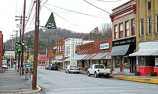
Rainelle is a town on the western edge of Greenbrier County, West Virginia, United States. It sits at the base of Sewell Mountain and Sims Mountain, and is bisected by the Meadow River. The only means of transportation to and from Rainelle are roads; primarily US 60 and WV 20, which merge on the western end of the town, and the James River and Kanawha Turnpike, which enters from the south. The population was 1,190 at the 2020 census.

<span class="mw-page-title-main">Rupert, West Virginia</span> Town in West Virginia, United States

Rupert is a town in Greenbrier County, West Virginia, United States. The population was 881 at the 2020 census.

<span class="mw-page-title-main">White Sulphur Springs, West Virginia</span> City in West Virginia, United States

White Sulphur Springs is a city in Greenbrier County in southeastern West Virginia, United States. The population was 2,231 at the 2020 census. The city emblem consists of five dandelion flowers and the citizens celebrate spring with an annual Dandelion Festival.

<span class="mw-page-title-main">Man, West Virginia</span> Town in West Virginia, United States

Man is a town in Logan County, West Virginia, United States. The population was 772 at the 2020 census. The town is located along the Guyandotte River at the mouth of Buffalo Creek, which was the site of the 1972 Buffalo Creek Flood following a dam collapse. The name of the town reportedly derives from the last syllable of the surname of Ulysses Hinchman, who was a member of the House of Delegates from Logan County between 1866 and 1869.

<span class="mw-page-title-main">West Logan, West Virginia</span> Town in West Virginia, United States

West Logan is a town along the Guyandotte River in Logan County, West Virginia, United States. The population was 400 at the 2020 census. For unknown reasons, some sources report West Logan to lay west of the county seat at Logan, attributing to this fact the name.

<span class="mw-page-title-main">Durbin, West Virginia</span> Town in West Virginia, United States

Durbin is a town in Pocahontas County, West Virginia, United States. The population was 235 at the 2020 census.

<span class="mw-page-title-main">Marlinton, West Virginia</span> Town in West Virginia, United States

Marlinton is a town in and the county seat of Pocahontas County, West Virginia, United States. The population was 998 at the 2020 census. Located along the Greenbrier River, it is known for its scenery.

<span class="mw-page-title-main">Albright, West Virginia</span> Town in West Virginia, United States

Albright is a town in central Preston County, West Virginia, United States, along the Cheat River. The population was 260 at the 2020 census. A former coal town, it is part of the Morgantown metropolitan area.

<span class="mw-page-title-main">Rowlesburg, West Virginia</span> Town in West Virginia, United States

Rowlesburg is a town in southern Preston County, West Virginia, United States, along the Cheat River. The population was 438 at the 2020 census. It is part of the Morgantown metropolitan area. A former railroad town, it is home to the Downtown Rowlesburg Historic District, and was the site of action during the American Civil War.

<span class="mw-page-title-main">Tunnelton, West Virginia</span> Town in West Virginia, United States

Tunnelton is a town in southwestern Preston County, West Virginia, United States. The population was 307 at the 2020 census. It is part of the Morgantown metropolitan area.

<span class="mw-page-title-main">Friendly, West Virginia</span> Town in West Virginia, United States

Friendly is a town in Tyler County, West Virginia, United States. The population was 100 at the 2020 census.

<span class="mw-page-title-main">Alderson, West Virginia</span> Town in West Virginia, United States

Alderson is a town in Greenbrier and Monroe counties in the U.S. state of West Virginia, on both sides of the Greenbrier River. The population was 975 at the 2020 census.

References

  1. "2019 U.S. Gazetteer Files". United States Census Bureau. Retrieved August 7, 2020.
  2. 1 2 U.S. Geological Survey Geographic Names Information System: Ronceverte, West Virginia
  3. 1 2 3 4 "City and Town Population Totals: 2020-2021". Census.gov. US Census Bureau. Retrieved July 3, 2022.
  4. 1 2 "U.S. Census website". United States Census Bureau . Retrieved January 31, 2008.
  5. "Ronceverte--Name Chosen for Our Town"--Riders of the Flood Historic Newsletter, 2000.
  6. Kenny, Hamill (1945). West Virginia Place Names: Their Origin and Meaning, Including the Nomenclature of the Streams and Mountains. Piedmont, WV: The Place Name Press. p. 540.
  7. Greenbrier River Org.
  8. "The Flood of 1985 remembered". November 2, 2015. Retrieved June 28, 2018.
  9. "National Register Information System". National Register of Historic Places . National Park Service. July 9, 2010.
  10. "US Gazetteer files 2010". United States Census Bureau. Archived from the original on January 25, 2012. Retrieved January 24, 2013.
  11. "Census of Population and Housing". Census.gov. Retrieved June 4, 2015.
  12. "U.S. Census website". United States Census Bureau . Retrieved January 24, 2013.
  13. Ronceverte Public Library
  14. Riders of the Flood Outdoor Drama
  15. St. Lawrence Boom and Lumber Co.
  16. WV Institute for Outdoor Drama