Moundsville, West Virginia

Last updated

Moundsville, West Virginia
Moundsville West Virginia.jpg
Jefferson Avenue in downtown Moundsville
Flag of Moundsville, West Virginia.svg
Seal of Moundsville, West Virginia.png
Marshall County West Virginia Incorporated and Unincorporated areas Moundsville Highlighted.svg
Location of Moundsville in Marshall County, West Virginia.
Coordinates: 39°55′N80°44′W / 39.917°N 80.733°W / 39.917; -80.733
CountryUnited States
State West Virginia
County Flag of Marshall County, West Virginia.svg Marshall
Government
  Type Council-Manager
   Mayor Sara Wood-Shaw
  City ManagerRichard Healy
Area
[1]
  Total3.36 sq mi (8.70 km2)
  Land2.91 sq mi (7.53 km2)
  Water0.45 sq mi (1.17 km2)
Elevation
696 ft (212 m)
Population
 (2020) [2]
  Total8,122
  Estimate 
(2021) [2]
7,981
  Density2,400/sq mi (930/km2)
Time zone UTC-5 (Eastern (EST))
  Summer (DST) UTC-4 (EDT)
ZIP code
26041
Area code 304
FIPS code 54-56020
GNIS feature ID1543607 [3]
Website www.cityofmoundsville.com

Moundsville is a city in and the county seat of Marshall County, West Virginia, United States, along the Ohio River. [4] The population was 8,122 at the 2020 census. [2] It is part of the Wheeling metropolitan area. The city was named for the nearby ancient Grave Creek Mound, constructed 250 to 100 BC by indigenous people of the Adena culture. [5]

Contents

History

Grave Creek Mound Grave Creek Mound.jpg
Grave Creek Mound

In 1771, English colonists Samuel and James Tomlinson built a cabin at what later became Moundsville, although they did not overwinter, and in fact left for several years after attacks by Native Americans. Elizabethtown, as Tomlinson's community was called, was incorporated in 1830 and would become the county seat upon the creation of Marshall County in 1835. Nearby, the town of Mound City was incorporated in 1832. The two towns combined in 1865. [6] In 1852 a line of the Baltimore and Ohio Railroad opened, connecting the eastern rail network with the Ohio and Mississippi riverboat system; Moundsville was an important port until 1861, when the Civil War shut down the river system and caused major damage to the railroad.[ citation needed ] Fostoria Glass Company (specializing in hand-blown glassworks) was headquartered in Moundsville from 1891 to 1986. The retired West Virginia State Penitentiary operated in Moundsville from 1867 to 1995. [7] On August 4, 1927, Charles Lindbergh landed The Spirit of St. Louis at Langin Field in Moundsville. [8]

Geography

Moundsville Bridge Moundsville Bridge.jpg
Moundsville Bridge

According to the United States Census Bureau, the city has a total area of 3.36 square miles (8.70 km2), of which 2.91 square miles (7.54 km2) is land and 0.45 square miles (1.17 km2) is water. [9]

Climate

The climate in this area is characterized by relatively high temperatures and evenly distributed precipitation throughout the year. According to the Köppen Climate Classification system, Moundsville has a Humid subtropical climate, abbreviated "Cfa" on climate maps. [10]

Climate data for Moundsville, West Virginia (1991–2020 normals, extremes 1963–present)
MonthJanFebMarAprMayJunJulAugSepOctNovDecYear
Record high °F (°C)74
(23)
80
(27)
86
(30)
92
(33)
94
(34)
101
(38)
105
(41)
102
(39)
97
(36)
93
(34)
82
(28)
78
(26)
105
(41)
Mean maximum °F (°C)64.0
(17.8)
66.2
(19.0)
75.4
(24.1)
84.4
(29.1)
88.7
(31.5)
92.8
(33.8)
94.6
(34.8)
93.2
(34.0)
90.9
(32.7)
82.8
(28.2)
74.5
(23.6)
64.2
(17.9)
95.7
(35.4)
Mean daily maximum °F (°C)39.3
(4.1)
42.7
(5.9)
52.1
(11.2)
65.1
(18.4)
74.5
(23.6)
82.2
(27.9)
85.8
(29.9)
84.6
(29.2)
78.5
(25.8)
66.7
(19.3)
54.2
(12.3)
43.6
(6.4)
64.1
(17.8)
Daily mean °F (°C)29.5
(−1.4)
32.0
(0.0)
40.4
(4.7)
51.5
(10.8)
61.7
(16.5)
69.9
(21.1)
73.8
(23.2)
72.6
(22.6)
65.9
(18.8)
54.2
(12.3)
42.8
(6.0)
34.3
(1.3)
52.4
(11.3)
Mean daily minimum °F (°C)19.7
(−6.8)
21.4
(−5.9)
28.6
(−1.9)
38.0
(3.3)
48.9
(9.4)
57.5
(14.2)
61.9
(16.6)
60.5
(15.8)
53.3
(11.8)
41.6
(5.3)
31.4
(−0.3)
25.0
(−3.9)
40.6
(4.8)
Mean minimum °F (°C)1.7
(−16.8)
6.1
(−14.4)
14.8
(−9.6)
26.8
(−2.9)
36.8
(2.7)
47.1
(8.4)
53.7
(12.1)
52.9
(11.6)
43.2
(6.2)
31.0
(−0.6)
20.6
(−6.3)
11.6
(−11.3)
−1.3
(−18.5)
Record low °F (°C)−20
(−29)
−15
(−26)
−3
(−19)
11
(−12)
25
(−4)
36
(2)
44
(7)
40
(4)
31
(−1)
18
(−8)
6
(−14)
−11
(−24)
−20
(−29)
Average precipitation inches (mm)3.77
(96)
3.13
(80)
3.87
(98)
3.68
(93)
4.47
(114)
4.89
(124)
4.52
(115)
3.82
(97)
3.88
(99)
3.23
(82)
3.15
(80)
3.72
(94)
46.13
(1,172)
Average snowfall inches (cm)6.0
(15)
4.7
(12)
2.4
(6.1)
0.1
(0.25)
0.0
(0.0)
0.0
(0.0)
0.0
(0.0)
0.0
(0.0)
0.0
(0.0)
0.0
(0.0)
0.1
(0.25)
2.5
(6.4)
15.8
(40)
Average precipitation days (≥ 0.01 in)14.211.712.314.014.112.511.110.29.610.410.913.2144.2
Average snowy days (≥ 0.1 in)4.13.11.00.10.00.00.00.00.00.00.12.410.8
Source: NOAA [11] [12]

Demographics

Historical population
CensusPop.Note
1850 445
1860 51515.7%
1870 1,500191.3%
1880 1,77418.3%
1890 2,68851.5%
1900 5,36299.5%
1910 8,91866.3%
1920 10,66919.6%
1930 14,41135.1%
1940 14,168−1.7%
1950 14,7724.3%
1960 15,1632.6%
1970 13,560−10.6%
1980 12,419−8.4%
1990 10,753−13.4%
2000 9,998−7.0%
2010 9,318−6.8%
2020 8,122−12.8%
2021 (est.)7,981 [2] −1.7%
U.S. Decennial Census [13]
2014 Estimate [14]

2010 census

As of the 2010 census, [15] there were 9,318 people, 4,016 households, and 2,445 families living in the city. The population density was 3,202.1 inhabitants per square mile (1,236.3/km2). There were 4,458 housing units at an average density of 1,532.0 per square mile (591.5/km2). The racial makeup of the city was 97.5% White, 0.8% African American, 0.2% Native American, 0.4% Asian, 0.2% from other races, and 0.9% from two or more races. Hispanic or Latino of any race were 1.1% of the population.

There were 4,016 households, of which 25.4% had children under the age of 18 living with them, 41.2% were married couples living together, 14.5% had a female householder with no husband present, 5.1% had a male householder with no wife present, and 39.1% were non-families. 33.7% of all households were made up of individuals, and 16.4% had someone living alone who was 65 years of age or older. The average household size was 2.21 and the average family size was 2.79.

The median age in the city was 45.2 years. 19.4% of residents were under the age of 18; 7.1% were between the ages of 18 and 24; 23.2% were from 25 to 44; 30.1% were from 45 to 64; and 20.1% were 65 years of age or older. The gender makeup of the city was 47.9% male and 52.1% female.

2000 census

As of the 2000 census, there were 9,998 people, 4,122 households, and 2,662 families living in the city. The population density was 3,399.0 people per square mile (1,313.0/km2). There were 4,461 housing units at an average density of 1,516.6 per square mile (585.9/km2). The racial makeup of the city was 98.13% White, 0.73% African American, 0.13% Native American, 0.30% Asian, 0.01% Pacific Islander, 0.10% from other races, and 0.60% from two or more races. Hispanic or Latino of any race were 1.16% of the population.

There were 4,122 households, out of which 25.5% had children under the age of 18 living with them, 47.7% were married couples living together, 13.3% had a female householder with no husband present, and 35.4% were non-families. 31.4% of all households were made up of individuals, and 17.0% had someone living alone who was 65 years of age or older. The average household size was 2.28 and the average family size was 2.84.

In the city the population was spread out, with 20.4% under the age of 18, 7.8% from 18 to 24, 26.8% from 25 to 44, 24.9% from 45 to 64, and 20.0% who were 65 years of age or older. The median age was 42 years. For every 100 females, there were 92.3 males. For every 100 females age 18 and over, there were 89.0 males.

The median income for a household in the city was $23,107, and the median income for a family was $30,534. Males had a median income of $26,242 versus $19,348 for females. The per capita income for the city was $13,997. About 18.1% of families and 22.4% of the population were below the poverty line, including 33.2% of those under age 18 and 15.5% of those age 65 or over.

Notable people

West Virginia State Penitentiary West Virginia State Penitentiary, Moundsville, WV.jpg
West Virginia State Penitentiary

In 2018, documentary filmmakers David Bernabo and John W. Miller released Moundsville, [16] a documentary about the history of Moundsville.

You Missed My Heart, a song by Mark Kozelek of Sun Kil Moon and Jimmy LaValle, references a prison cemetery in Moundsville. [17] This song has also been covered by Phoebe Bridgers. [18]

Related Research Articles

<span class="mw-page-title-main">Burnsville, West Virginia</span> Town in West Virginia, United States

Burnsville is a town in Braxton County, West Virginia, United States, at the confluence of the Little Kanawha River and Saltlick Creek. The population was 401 at the 2020 census. Burnsville was incorporated in 1902 by the Circuit Court and named for Captain John Burns who operated the first sawmill in that section of the state and who established the town shortly after the close of the American Civil War. It was named "All West Virginia City" in 1976.

<span class="mw-page-title-main">Grantsville, West Virginia</span> Town in West Virginia, United States

Grantsville is a town in Calhoun County, West Virginia, United States. The population was 482 at the 2020 census. It is the county seat of Calhoun County. The town was established along the Little Kanawha River in 1865 and named for Ulysses S. Grant. Grantsville is home to Wayne Underwood Park, which includes a .25-mile-long (0.40 km) walking trail, and to the annual West Virginia Wood Festival.

<span class="mw-page-title-main">Clay, West Virginia</span> Town in West Virginia, United States

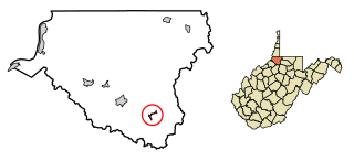
Clay is a town in and the county seat of Clay County, West Virginia, United States. The population was 399 at the 2020 census. It is the only incorporated town in Clay County.

<span class="mw-page-title-main">Petersburg, West Virginia</span> City in West Virginia, United States

Petersburg is a city in Grant County, West Virginia, United States. The population was 2,251 at the 2020 census. It is the county seat of Grant County.

<span class="mw-page-title-main">Ripley, West Virginia</span> City in West Virginia, United States

Ripley is a city in and the county seat of Jackson County, West Virginia, United States. The population was 3,074 at the 2020 census.

<span class="mw-page-title-main">Jane Lew, West Virginia</span> Town in West Virginia, United States

Jane Lew is a town in Lewis County, West Virginia, United States. The population was 409 at the time of the 2020 census.

<span class="mw-page-title-main">Weston, West Virginia</span> City in West Virginia, United States

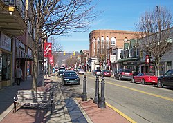
Weston is a city in and the county seat of Lewis County, West Virginia, United States. The population was 3,943 at the 2020 census. It is home to the Museum of American Glass in West Virginia and the Trans-Allegheny Lunatic Asylum.

<span class="mw-page-title-main">Henderson, West Virginia</span> Unincorporated Town in West Virginia, United States

Henderson is an unincorporated community and former town in Mason County, West Virginia, United States, at the confluence of the Ohio and Kanawha Rivers. The population was 231 at the 2020 census. It is part of the Point Pleasant, WV–OH Micropolitan Statistical Area. The town was incorporated in 1893 and named for Samuel Bruce Henderson, who owned the townsite at the time. The town was unincorporated following a public hearing on August 11, 2022.

<span class="mw-page-title-main">Granville, West Virginia</span> Town in West Virginia

Granville is a town in Monongalia County, West Virginia, United States. The population was 1,355 at the 2020 census. It is included in the Morgantown metropolitan area.

<span class="mw-page-title-main">Albright, West Virginia</span> Town in West Virginia, United States

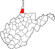
Albright is a town in central Preston County, West Virginia, United States, along the Cheat River. The population was 260 at the 2020 census. A former coal town, it is part of the Morgantown metropolitan area.

<span class="mw-page-title-main">Bruceton Mills, West Virginia</span> Town in West Virginia, United States

Bruceton Mills is a town in northern Preston County, West Virginia, United States, along Big Sandy Creek. The population was 64 at the 2020 census, making it the second-least populous town in West Virginia, after Thurmond. It is part of the Morgantown metropolitan area.

<span class="mw-page-title-main">Cairo, West Virginia</span> Town in West Virginia, United States

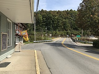
Cairo is a town in Ritchie County, West Virginia, United States, along West Virginia Route 31, the North Fork of the Hughes River, and the North Bend Rail Trail. The population was 174 at the 2020 census.

<span class="mw-page-title-main">Spencer, West Virginia</span> City in West Virginia, United States

Spencer is a city in and the county seat of Roane County, West Virginia, United States. Originally known as "California," Spencer was chartered in 1858, and named after Spencer Roane (1762–1822), a distinguished jurist from Virginia, who served on the Virginia Supreme Court of Appeals, and for whom Roane County was named. The population was 2,062 at the 2020 census. Spencer is the home of the annual West Virginia Black Walnut Festival. Points of interest include Charles Fork Lake, Chrystal Water and Power Company-Spencer Water and Ice Company, the McIntosh Mansion, and the Robey Theatre.

<span class="mw-page-title-main">Parsons, West Virginia</span> City in West Virginia, United States

Parsons is the largest city in and county seat of Tucker County, West Virginia, United States. The population was 1,322 at the 2020 census. Parsons is located at the confluence of the Shavers Fork and the Black Fork, forming the head of the Cheat River.

<span class="mw-page-title-main">Middlebourne, West Virginia</span> Town in West Virginia, United States

Middlebourne is a town in Tyler County, West Virginia, United States. The population was 715 at the 2020 census. It serves as the county seat of Tyler County.

<span class="mw-page-title-main">Wayne, West Virginia</span> Town in West Virginia, United States

Wayne is a town in and the county seat of Wayne County, West Virginia, United States. The population was 1,441 at the 2020 census. It is part of the Huntington–Ashland metropolitan area.

<span class="mw-page-title-main">New Martinsville, West Virginia</span> City in West Virginia, United States

New Martinsville is a city in and the county seat of Wetzel County, West Virginia, United States, along the Ohio River. The population was 5,186 at the 2020 census.

<span class="mw-page-title-main">Smithfield, West Virginia</span> Town in West Virginia, United States

Smithfield is a town in Wetzel County, West Virginia, United States. The population was 103 at the 2020 census.

<span class="mw-page-title-main">Elizabeth, West Virginia</span> Town in West Virginia, United States

Elizabeth is a town in and the county seat of Wirt County, West Virginia, United States, situated along the Little Kanawha River. The population was 724 as of the 2020 census.

<span class="mw-page-title-main">Oceana, West Virginia</span> Town in West Virginia, United States

Oceana is a town in Wyoming County, West Virginia. The population was 1,462 at the time of the 2020 census. Oceana is the oldest city in Wyoming County and was the county seat until 1907.

References

  1. "2019 U.S. Gazetteer Files". United States Census Bureau. Retrieved August 7, 2020.
  2. 1 2 3 4 "City and Town Population Totals: 2020-2021". Census.gov. US Census Bureau. Retrieved July 2, 2022.
  3. "US Board on Geographic Names". United States Geological Survey. October 25, 2007. Retrieved January 31, 2008.
  4. "Find a County". National Association of Counties. Retrieved June 7, 2011.
  5. Comins, Linda S. (2006). "Moundsville". In Ken Sullivan (ed.). The West Virginia Encyclopedia. Charleston, W.Va.: West Virginia Humanities Council. p. 505. ISBN   0-9778498-0-5.
  6. Marshall County Historical Society. History of Marshall County, West Virginia. Marceline, Mo.: Walsworth, 1984. p. 975.416 M367m.
  7. Bumgardner, Stan (2006). "Moundsville Penitentiary". In Ken Sullivan (ed.). The West Virginia Encyclopedia. Charleston, W.Va.: West Virginia Humanities Council. p. 505. ISBN   0-9778498-0-5.
  8. "On This Day in West Virginia History - August 4".
  9. "US Gazetteer files 2010". United States Census Bureau. Archived from the original on July 2, 2012. Retrieved January 24, 2013.
  10. Climate Summary for Moundsville, West, Virginia
  11. "NowData – NOAA Online Weather Data". National Oceanic and Atmospheric Administration. Retrieved June 10, 2021.
  12. "Station: Moundsville, WV". U.S. Climate Normals 2020: U.S. Monthly Climate Normals (1991–2020). National Oceanic and Atmospheric Administration. Retrieved June 10, 2021.
  13. United States Census Bureau. "Census of Population and Housing" . Retrieved August 27, 2013.
  14. "Population Estimates". United States Census Bureau. Archived from the original on May 22, 2015. Retrieved June 19, 2015.
  15. "U.S. Census website". United States Census Bureau . Retrieved January 24, 2013.
  16. Edinger, Nora. ""Moundsville" — the Happy, the Sad, the Past, the Future Summed Up in Documentary – Weelunk" . Retrieved January 12, 2019.
  17. Mark Kozelek & Jimmy LaValle (Ft. Jimmy LaValle & Mark Kozelek) – You Missed My Heart , retrieved June 9, 2022
  18. Phoebe Bridgers – You Missed My Heart , retrieved June 9, 2022