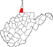
The Northern Panhandle is the northern of the two panhandles in the U.S. state of West Virginia. It is a culturally and geographically distinct region of the state. It is the state's northernmost extension, bounded by Ohio and the Ohio River on the north and west and the state of Pennsylvania on the east. Its unusual configuration is the result of the Revolutionary-era claims of Virginia's former Yohogania County boundary lying along the Ohio River, conflicting with interpretations of the Colony of Pennsylvania's royal charter. The conflict was settled by compromise in the 1780s. Today, due to the southern boundary being an extension of the Mason–Dixon line and the panhandle's proximity to the Pittsburgh area, the Northern Panhandle resembles more of the Midwestern United States or the Northeastern United States compared to the rest of the state, which is classified as part of the Upland South.
Chapel Hill or Chapelhill may refer to:

Marshall University is a public research university in Huntington, West Virginia. It was founded in 1837 and is named after John Marshall, the fourth Chief Justice of the United States.

Marshall is a census-designated place (CDP) and unincorporated town in northwestern Fauquier County, Virginia, in the United States. The population as of the 2010 census was 1,480.
Back Creek is a 59.5-mile-long (95.8 km) tributary of the Potomac River that flows north from Frederick County, Virginia, to Berkeley County in West Virginia's Eastern Panhandle. Back Creek originates along Frederick County's border with Hampshire County, West Virginia, at Farmer's Gap in the Great North Mountain. Its name reflects its location to the west of North Mountain. The perspective of colonists from the east in the 18th century led them to call it "Back Creek", because it lay to the back of North Mountain.
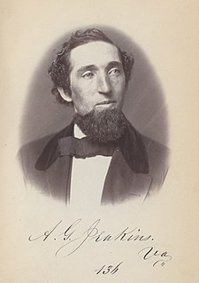
Albert Gallatin Jenkins was an attorney, planter, representative to the United States Congress and First Confederate Congress, and a Confederate brigadier general during the American Civil War. The commander of a brigade of cavalry from what would become West Virginia, he was mortally wounded at the Battle of Cloyd's Mountain near Dublin, Virginia.
Sand Hill, Sandhill, Sand Hills, or Sandhills may refer to:
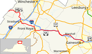
State Route 55 is a primary state highway in the U.S. state of Virginia. Known for most of its length as John Marshall Highway, the state highway runs 64.71 miles (104.14 km) from the West Virginia state line, where the highway continues as West Virginia Route 55, east to U.S. Route 29 in Gainesville. West of its interchange with Interstate 81 (I-81) in Strasburg, SR 55 runs concurrently with the easternmost portion of US 48 as part of Corridor H. East of Front Royal, the state highway serves as the local complement of I-66 as it passes through the towns of Marshall, The Plains, and Haymarket.

John Marshall High School is a public high school in Glen Dale, West Virginia, United States. It is one of two high schools in the Marshall County School District. Athletic teams compete as the John Marshall Monarchs in the WVSSAC Class AAA, as well as the Ohio Valley Athletic Conference.
Dallas is an unincorporated community in northeastern Marshall County, West Virginia, United States. It lies along local roads northeast of the city of Moundsville, the county seat of Marshall County, and almost in Pennsylvania. Its elevation is 1,388 feet (423 m). Although it is unincorporated, it has a post office, with the ZIP code of 26036.

Burches Run Wildlife Management Area, formerly Burches Run Lake WMA, is located on 55 acres (22 ha) near Wheeling in Marshall County, West Virginia. Until 2005 the wildlife management area contained a lake impounded by a dam at risk of failure. The name change occurred after the dam was removed. The terrain climbs gently above Burches Run and is covered by a mature oak-hickory second-growth forest.

Sand Hill Wildlife Management Area is located near Parkersburg, West Virginia in Wood and Ritchie counties. Sand Hill WMA is located on 1,987 acres (804 ha) of rugged, hilly oak-hickory woodlands interspersed with timber, oil and gas development sites.

Shannondale Springs Wildlife Management Area is located near Charles Town, West Virginia in Jefferson County. Shannondale Springs WMA is located on 1,361 acres (551 ha) of hills covered with oak-hickory woodlands, brushy areas, and open fields.
Marshall is an unincorporated community in Jackson County, West Virginia, United States. Marshall is located on U.S. Route 33 and Little Mill Creek 9.5 miles (15.3 km) east of Ripley.
Sand Hill is an unincorporated community in Wood County, West Virginia.
McKeefrey is an unincorporated community in Marshall County, West Virginia. It was also known as Round Bottom and Chestnut Hill.
Sand Hill, West Virginia may refer to:
Marshall County Schools is a school district headquartered in Moundsville, West Virginia, serving all of Marshall County.