Powellton, West Virginia

Last updated

Powellton, West Virginia
CDP
WVMap-doton-Powellton.PNG
Location of Powellton, West Virginia
Coordinates: 38°6′27″N81°19′15″W / 38.10750°N 81.32083°W / 38.10750; -81.32083
Country United States
State West Virginia
County Fayette
Area
[1]
  Total5.4 sq mi (13.9 km2)
  Land5.4 sq mi (13.9 km2)
  Water0.0 sq mi (0.0 km2)
Elevation
840 ft (256 m)
Population
 (2010) [2]
  Total619
  Density110/sq mi (45/km2)
Time zone UTC-5 (Eastern (EST))
  Summer (DST) UTC-4 (EDT)
ZIP code
25161
Area code 304
FIPS code 54-65284 [3]
GNIS feature ID1545222 [4]

Powellton is a census-designated place (CDP) in Fayette County, West Virginia, United States. The population was 619 at the 2010 census. [2]

Contents

The community most likely was named after Godwin H. Powell, a businessperson in the coal-mining industry. [5]

Geography

Powellton is located at 38°6′27″N81°19′15″W / 38.10750°N 81.32083°W / 38.10750; -81.32083 (38.107412, -81.320872). [1]

According to the United States Census Bureau, the CDP has a total area of 5.4 square miles (13.9 km2), all land. Armstrong Creek and its tributary, the Powellton Fork, flow through Powellton. [6]

Demographics

At the 2000 census there were 1,796 people, 697 households, and 515 families living in the CDP. The population density was 50.5 people per square mile (19.5/km2). There were 781 housing units at an average density of 22.0/sq mi (8.5/km2). The racial makeup of the CDP was 88.08% White, 9.35% African American, 0.28% Native American, 0.17% Asian, and 2.12% from two or more races. Hispanic or Latino of any race were 0.39%. [3]

Of the 697 households 26.7% had children under the age of 18 living with them, 57.2% were married couples living together, 12.2% had a female householder with no husband present, and 26.1% were non-families. 21.8% of households were one person and 10.9% were one person aged 65 or older. The average household size was 2.58 and the average family size was 2.97.

The age distribution was 21.7% under the age of 18, 10.7% from 18 to 24, 25.7% from 25 to 44, 26.9% from 45 to 64, and 14.9% 65 or older. The median age was 40 years. For every 100 females, there were 96.7 males. For every 100 females age 18 and over, there were 90.9 males.

The median household income was $23,224 and the median family income was $30,327. Males had a median income of $27,083 versus $20,060 for females. The per capita income for the CDP was $13,646. About 19.1% of families and 21.7% of the population were below the poverty line, including 38.2% of those under age 18 and 13.7% of those age 65 or over.

Related Research Articles

<span class="mw-page-title-main">Theodore, Alabama</span> Census-designated place in Alabama, United States

Theodore is an unincorporated area and census-designated place (CDP) in Mobile County, Alabama, United States. The population was 6,270 at the 2020 census. It is a part of the Mobile metropolitan area. Prior to 1900 this area was known as "Clements", but it is now named for William Theodore Hieronymous, a sawmill operator and postmaster.

<span class="mw-page-title-main">Lely, Florida</span> Census-designated place in Florida

Lely is a census-designated place (CDP) in Collier County, Florida, United States. The population was 3,451 at the 2010 census. It is part of the Naples–Marco Island Metropolitan Statistical Area.

<span class="mw-page-title-main">Wright, Florida</span> Census-designated place in Florida

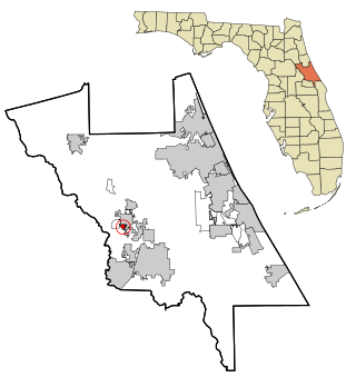
Wright is a census-designated place (CDP) in Okaloosa County, Florida, United States. The population was 23,127 at the 2010 United States Census. It is part of the Fort Walton Beach–Crestview–Destin Metropolitan Statistical Area.

Limestone Creek is a census-designated place (CDP) in Palm Beach County, Florida, United States. The population was 1,316 at the 2020 census.

<span class="mw-page-title-main">DeLand Southwest, Florida</span> CDP in Florida, United States

DeLand Southwest is an unincorporated census-designated place located in Volusia County, Florida, United States. The population was 1,056 at the 2020 census.

<span class="mw-page-title-main">Pepeekeo, Hawaii</span> Census-designated place in Hawaii, U.S.

Pepeekeo is a census-designated place (CDP) in Hawaii County, Hawaii, United States. The population was 1,789 at the 2010 census, up from 1,697 at the 2000 census.

<span class="mw-page-title-main">Harris, Kansas</span> Unincorporated community in Anderson County, Kansas

Harris is an unincorporated community in Anderson County, Kansas, United States. As of the 2020 census, the population of the community and nearby areas was 47.

<span class="mw-page-title-main">Shark River Hills, New Jersey</span> Populated place in Monmouth County, New Jersey, US

Shark River Hills is an unincorporated community and census-designated place (CDP) within Neptune Township, in Monmouth County, in the U.S. state of New Jersey. As of the 2010 United States Census, the CDP's population was 3,697.

Whitfield is a census-designated place (CDP) in Berks County, Pennsylvania, United States. The population was 4,733 at the 2010 census.

<span class="mw-page-title-main">Hyde, Pennsylvania</span> Census-designated place in Pennsylvania, United States

Hyde is an unincorporated community and census-designated place (CDP) in Clearfield County, Pennsylvania, United States. The population was 1,303 at the 2020 census.

<span class="mw-page-title-main">Cumberland Hill, Rhode Island</span> Census-designated place in Rhode Island, United States

Cumberland Hill is a census-designated place (CDP) in the town of Cumberland, in Providence County, Rhode Island, United States. The population was 7,934 at the 2010 census.

<span class="mw-page-title-main">North Eagle Butte, South Dakota</span> Census-designated place in South Dakota, United States

North Eagle Butte is a census-designated place (CDP) in Dewey County, South Dakota, United States, along the 45th parallel. The population was 1,879 at the 2020 census.

Oak Grove is a census-designated place (CDP) in Washington County, Tennessee, United States. The population was 4,425 at the 2010 census. It is part of the Johnson City Metropolitan Statistical Area, which is a component of the Johnson City–Kingsport–Bristol, TN-VA Combined Statistical Area – commonly known as the "Tri-Cities" region.

<span class="mw-page-title-main">Erda, Utah</span> City in Utah, United States

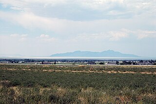
Erda is a city in Tooele County, Utah, United States. The population was 4,642 at the 2010 census, a significant increase from the 2000 figure of 2,473. Erda was previously a Census Designated Place (CDP) and a township but officially received its incorporation certificate in January 2022.

<span class="mw-page-title-main">Coal Fork, West Virginia</span> Census-designated place in West Virginia, United States

Coal Fork is an unincorporated census-designated place (CDP) in Kanawha County, West Virginia, United States. It is part of a larger unincorporated community known as Campbells Creek, approximately 10 minutes east of Charleston. The population was 1,233 at the 2010 census.

<span class="mw-page-title-main">Elkview, West Virginia</span> Census-designated place in West Virginia, United States

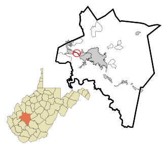
Elkview is a census-designated place (CDP) in Kanawha County, West Virginia, United States. The population was 1,222 at the 2010 census. It is named after the Elk River, which flows into the Kanawha River.

<span class="mw-page-title-main">Jefferson, West Virginia</span> Census-designated place in West Virginia, United States

Jefferson is a census-designated place (CDP) in Kanawha County, West Virginia, United States, along the Kanawha River. The population was 676 at the 2010 census. Jefferson was incorporated on March 22, 1997, but was disincorporated less than a decade later on February 21, 2007.

<span class="mw-page-title-main">Gilbert Creek, West Virginia</span> CDP in West Virginia, United States

Gilbert Creek is a census-designated place (CDP) in Mingo County, West Virginia, United States. The population was 1,090 at the 2010 census. The community takes its name from nearby Gilbert Creek.

<span class="mw-page-title-main">Piney View, West Virginia</span> Census-designated place in West Virginia, United States

Piney View is a census-designated place (CDP) in Raleigh County, West Virginia, United States. The population was 989 at the 2010 census.

<span class="mw-page-title-main">Lubeck, West Virginia</span> CDP in West Virginia, United States

Lubeck is a census-designated place (CDP) in Wood County, West Virginia, United States. It is part of the Parkersburg-Marietta-Vienna, WV-OH Metropolitan Statistical Area. The population was 1,311 at the 2010 census. Though first named Watertown, postmaster Theodore Frederick Henry Slevogt in 1856 changed the name to Lubeck after his hometown in Germany.

References

  1. 1 2 "US Gazetteer files: 2010, 2000, and 1990". United States Census Bureau. February 12, 2011. Retrieved April 23, 2011.
  2. 1 2 "U.S. Census website". United States Census Bureau . Retrieved May 14, 2011.
  3. 1 2 "U.S. Census website". United States Census Bureau . Retrieved January 31, 2008.
  4. "US Board on Geographic Names". United States Geological Survey. October 25, 2007. Retrieved January 31, 2008.
  5. Kenny, Hamill (1945). West Virginia Place Names: Their Origin and Meaning, Including the Nomenclature of the Streams and Mountains. Piedmont, WV: The Place Name Press. p. 505.
  6. The National Map, accessed 2013-11-26