
West Virginia is a state in the Appalachian, Mid-Atlantic and Southeastern regions of the United States. It is bordered by Pennsylvania to the north and east, Maryland to the east and northeast, Virginia to the southeast, Kentucky to the southwest, and Ohio to the northwest. West Virginia is the 10th-smallest state by area and ranks as the 12th-least populous state, with a population of 1,793,716 residents. The capital and largest city is Charleston.
Taylor County is a county in the U.S. state of West Virginia. As of the 2010 census, the population was 16,895. Its county seat is Grafton. The county was formed in 1844 and named for Senator John Taylor of Caroline.

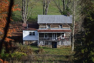
Sissonville is a census-designated place (CDP) in Kanawha County, West Virginia, United States, along the Pocatalico River. The population was 4,028 at the 2010 census. Sissonville is located within 14 miles of Charleston, the state capital.

The Newfoundland Railway operated on the island of Newfoundland from 1898 to 1988. With a total track length of 906 miles (1,458 km), it was the longest 3 ft 6 in narrow-gauge railway system in North America.
Grand Falls-Windsor—Buchans is a provincial electoral district for the House of Assembly of Newfoundland and Labrador, Canada. Prior to 2006, the district was Grand Falls-Buchans, while expanded slightly in all directions it took in no major municipalities. As of 2011, there are 7,450 eligible voters living within the district.

The Pocatalico River is a tributary of the Kanawha River, approximately 75 miles (121 km) long, in west-central West Virginia in the United States. Via the Kanawha and Ohio rivers, it is part of the watershed of the Mississippi River.
Quarry is an abandoned railway community that was located in the Gaff Topsails area of the province of Newfoundland, Canada. The community lies just north of Buchans and takes its name from the quarry established in the 1890s when the Newfoundland Railway was being built.
Gaff Topsail is an abandoned railway settlement located in the interior of Newfoundland, Canada, between the communities of Millertown Junction to the east and Kitty's Brook to the west. The population was entirely composed of railway workers who worked on the Newfoundland Railway and their families.

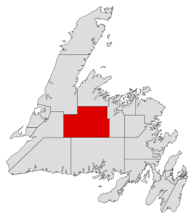
Division No. 6 is a census division in the central part of the island of Newfoundland in the province of Newfoundland and Labrador, Canada. It is divided into 16 parts; 12 towns and four unorganized subdivisions.
Division No. 6, Subd. A is an unorganized subdivision in north-central Newfoundland, Newfoundland and Labrador, Canada. It is in Division No. 6. It surrounds the towns of Buchans and Millertown.
Millertown is a town in the Canadian province of Newfoundland and Labrador on the north-east side of Red Indian Lake. The town had a population of 87 in the Canada 2021 Census.
The following radio stations broadcast on FM frequency 90.1 MHz:
Millertown Junction is a settlement on the island of Newfoundland in the Canadian Province of Newfoundland and Labrador. It is located at the northeast end of the small lake called Joe Glodes Pond, about where the original railway settlement was though summer cabins have spread in recent years down the eastern fringe of the lake, and a short distance to the west. Millertown Junction was last officially reported in the census in 1981 when it returned a population of 23, the latest in a series of dramatic falls connected with the closing of the railway. Recent years have seen an increase in population, however.
Buchans Junction is a local service district and designated place in the Canadian province of Newfoundland and Labrador in the central part of the island of Newfoundland. It is on the banks of Mary March River near where the Mary March River flows into the northeast end of Red Indian Lake. The community is on a site first known as "Four Mile Siding" on the railway which was constructed in 1900 to connect the community of Millertown to the Newfoundland Railway at Millertown Junction. The site itself became a rail junction in 1927 when Asarco subsidiary, the Buchans Mining Company, completed a rail link from the newly formed mining town of Buchans. Ever since 1927, even after the Buchans Railway closed in 1977, the community has been known as "Buchans Junction."
Alec Snow is a businessperson and former politician in Labrador. He represented Menihek in the Newfoundland House of Assembly from 1989 to 1996.
Millertown is an unincorporated community in Perry County, in the U.S. state of Ohio.
Route 370, also known as the Buchans Highway, is a 73-kilometre-long (45 mi) east-west highway in the central portion of Newfoundland in the Canadian province of Newfoundland and Labrador. Its eastern terminus is the intersection at the Trans-Canada Highway in the Town of Badger, and the route ends at the Town of Buchans.
Route 371, also known as Millertown Junction Road, is a 19.9-kilometre-long (12.4 mi) north–south highway in central Newfoundland in the Canadian province of Newfoundland and Labrador. It is an entirely unsigned, narrow, gravel road for its entire length, serving as the only access road to the community of Millertown Junction, connecting with Route 370 at the other end. It is believed by some that this road has been abandoned, even though this is clearly not the case. There are no other major intersections or communities along the entire length of Route 371.
Millertown is an unincorporated community in central-eastern Knox County, Tennessee, United States. Millertown is 7.9 miles (12.7 km) northeast of Knoxville.


