The Ohio River is a 981-mile (1,579 km) long river in the United States. It is located at the boundary of the Midwestern and Southern United States, flowing southwesterly from western Pennsylvania to its mouth on the Mississippi River at the southern tip of Illinois. It is the third largest river by discharge volume in the United States and the largest tributary by volume of the north-south flowing Mississippi River that divides the eastern from western United States. It is also the 6th oldest river on the North American continent. The river flows through or along the border of six states, and its drainage basin includes parts of 14 states. Through its largest tributary, the Tennessee River, the basin includes several states of the southeastern U.S. It is the source of drinking water for five million people.

Charleston is the capital and most populous city of West Virginia. Located at the confluence of the Elk and Kanawha rivers, the city had a population of 48,864 at the 2020 census and an estimated population of 48,018 in 2021. The Charleston metropolitan area as a whole had an estimated 255,020 residents in 2021. Charleston is the center of government, commerce, and industry for Kanawha County, of which it is the county seat.
Ohio County is a county located in the Northern Panhandle of the U.S. state of West Virginia. As of the 2010 census, the population was 44,443. Its county seat is Wheeling. The county was formed in 1776 from the District of West Augusta, Virginia. It was named for the Ohio River, which forms its western boundary with the state of Ohio. West Liberty was designated as the county seat in 1777, serving to 1797.

The Delmarva Peninsula, or simply Delmarva, is a large peninsula on the East Coast of the United States, occupied by the vast majority of the state of Delaware and parts of the Eastern Shore regions of Maryland and Virginia. The peninsula is 170 miles (274 km) long. In width, it ranges from 70 miles (113 km) near its center, to 12 miles (19 km) at the isthmus on its northern edge, to less near its southern tip of Cape Charles. It is bordered by the Chesapeake Bay on the west, Pocomoke Sound on the southwest, and the Delaware River, Delaware Bay, and the Atlantic Ocean on the east.

Gloucester County is a county in the Commonwealth of Virginia. As of the 2020 census, the population was 38,711. Its county seat is Gloucester Courthouse. The county was founded in 1651 in the Virginia Colony and is named for Henry Stuart, Duke of Gloucester.

West Point is an incorporated town in King William County, Virginia, United States. The population was 3,306 at the 2010 census.

Clendenin is a town in Kanawha County, West Virginia, United States, situated along the Elk River. The population was 850 at the 2020 census.
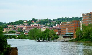
Morgantown is a city in and the county seat of Monongalia County, West Virginia, United States, situated along the Monongahela River. The largest city in North-Central West Virginia, Morgantown is best known as the home of West Virginia University. The population was 30,712 at the 2020 census. The city serves as the anchor of the Morgantown metropolitan area, which had a population of 138,176 in 2020.
The Middle Atlantic states, commonly shortened to Mid-Atlantic states, is a region of the United States generally located in the overlap between the Northeastern and Southeastern States. Its exact definition differs upon source, but the region typically includes Delaware, the District of Columbia, Maryland, New Jersey, New York, and Pennsylvania. When discussing climate, Connecticut is sometimes included in the region, as its climate is closer to that of the Mid-Atlantic states than the rest of the New England states. The Mid-Atlantic has played an important role in the development of American culture, commerce, trade, and industry; in the late 19th century, the Mid-Atlantic was called "the typically American" region by Frederick Jackson Turner.

The Monongahela River —often referred to locally as the Mon —is a 130-mile-long (210 km) river on the Allegheny Plateau in north-central West Virginia and southwestern Pennsylvania. The river flows from the confluence of its west and east forks in north-central West Virginia northeasterly into southwestern Pennsylvania, then northerly to Pittsburgh and its confluence with the Allegheny River to form the Ohio River. The river's entire length is navigable via a series of locks and dams.

The Great Appalachian Valley, also called The Great Valley or Great Valley Region, is one of the major landform features of eastern North America. It is a gigantic trough—a chain of valley lowlands—and the central feature of the Appalachian Mountain system. The trough stretches about 1,200 miles (1,900 km) from Quebec in the north to Alabama in the south and has been an important north–south route of travel since prehistoric times.

The Virginia Peninsula is a peninsula in southeast Virginia, USA, bounded by the York River, James River, Hampton Roads and Chesapeake Bay. It is sometimes known as the Lower Peninsula to distinguish it from two other peninsulas to the north, the Middle Peninsula and the Northern Neck.

The Middle Peninsula is the second of three large peninsulas on the western shore of Chesapeake Bay in Virginia, in the United States. As of the 2020 census, the Middle Peninsula was home to 92,886 people. It lies between the Northern Neck and the Virginia Peninsula. This peninsula is bounded by the Rappahannock River on the north and the York River on the south, with the Chesapeake Bay to the east. It encompasses six Virginia counties: Essex, Gloucester, King and Queen, King William, Mathews, and Middlesex. Developed for tobacco plantations in the colonial era, in the 21st century the Middle Peninsula is known for its quiet rural life, vegetable truck-farming, and fishing industry.

The Fairfax County Public Schools system (FCPS) is a school division in the U.S. commonwealth of Virginia. It is a branch of the Fairfax County government which administers public schools in Fairfax County and the City of Fairfax. FCPS's headquarters is located in the Gatehouse Administration Center in Merrifield, an unincorporated section of the county near the city of Falls Church; the headquarters has a Falls Church address but is not within the city limits.

The West End is a part of Richmond, Virginia. Definitions of the bounds of the West End vary, it may include only the western part of the city of Richmond or extend as far as western Henrico County. As there is no one municipal organization that represents this specific region, the boundaries are loosely defined as being north of the James River, west of I-195, and south of Broad Street. Historically, the Richmond neighborhoods of the Fan and the Museum District were a part of the West End. A primary conduit through the West End is Interstate 64.

Middle Island Creek is a river, 77 miles (124 km) long, in northwestern West Virginia in the United States. It is a tributary of the Ohio River, draining an area of 565 square miles (1,463 km2) on the unglaciated Allegheny Plateau. It was named by late 18th century pioneering travelers on the Ohio River, who noted the location of the Creek's mouth opposite Middle Island in the larger river.
The Jug — formerly known as the Jug Handle — is a jug-shaped island formed by a horseshoe bend on Middle Island Creek near Middlebourne in Tyler County, West Virginia, USA. It is maintained by the state of West Virginia as The Jug Wildlife Management Area.
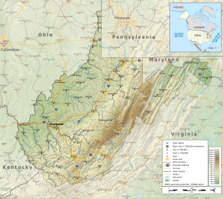
The Environment of West Virginia encompasses terrain and ecosystems ranging from plateaus to mountains. Most of West Virginia lies within the Appalachian mixed mesophytic forests ecoregion, while the higher elevations along the eastern border and in the panhandle lie within the Appalachian-Blue Ridge forests.

Audra State Park is a West Virginia state park located on 355 acres (1.44 km2) in southwestern Barbour County. It was established around the remnants of an early 19th-century gristmill and the tiny community of Audra. A gristmill spillway is still visible in the river.