Cape Blanco (Oregon)

Last updated

Cape Blanco State Park
Cape Blanco looking south.JPG
View from Cape Blanco, looking south towards Port Orford Heads State Park. Humbug Mountain in the distance.
USA Oregon location map.svg
Red pog.svg
Usa edcp location map.svg
Red pog.svg
TypePublic, state
Location Curry County, Oregon
Nearest city Port Orford
Coordinates 42°50′15″N124°33′50″W / 42.8376089°N 124.5639997°W / 42.8376089; -124.5639997 [1]
Area1,880 acres (760 ha)
Operated by Oregon Parks and Recreation Department
VisitorsAnnually, about 350,000 for day-use, 35,000 overnight [2]
OpenYear-round
Cape Blanco from space, October 1994 Cape blanco us.png
Cape Blanco from space, October 1994

Cape Blanco is a prominent headland on the Pacific Ocean coast of southwestern Oregon in the United States, forming the westernmost point in the state. [3] Cape Blanco extends farther west than any point of land in the contiguous United States (lower 48 states) except portions of the Olympic Peninsula in Washington, including Cape Alava, the true westernmost point. [4] The cape is part of Cape Blanco State Park and is the location of the Cape Blanco Light, first lit in 1870. [3]

Contents

The cape may have been named by explorer Martín de Aguilar in 1603 for its appearance, as blanco means "white" in Spanish. [4] [5] In 1775, Juan Francisco de la Bodega y Quadra named the point Cabo Diligensias. [4] It was later renamed Cape Orford by Captain George Vancouver in 1792, but this name fell into disuse and Cape Blanco became the common usage. [4]

Geology

The cape, a relatively level landform with cliffs facing the sea, is about 200 feet (61 m) higher than the ocean. It consists of layers of uplifted marine sediments, ranging in age from 80 million years at the bottom to less than 500,000 years at the top. [4] The uplift is continuing; Cape Blanco is rising by several millimeters each year. [6] Generally, landforms on the north and south end of the Oregon Coast are rising as the ocean floor slides under the continent, while the central part of the coast "seems to be folding down." [6]

Landforms near the cape include beaches, bluffs, and reefs. Visible to the south are Needle Rock, Blanco Reef, and Humbug Mountain. To the north are Gull Rock, Castle Rock, and Blacklock Point. [3] Blanco Reef is a group of irregular rocks and ledges that are from 2 to 5 miles (3 to 8 km) offshore and are up to 149 feet (45 m) high. [7]

Geography

Cape Blanco is in northern Curry County, about 4 miles (6 km) north of Port Orford, along a mountainous and isolated stretch of the coast bounded to the east by the Coast Range. [8] It lies about 5 miles (8 km) west of U.S. Route 101. [3]

The Sixes River empties into the Pacific Ocean along the north side of the cape. [8] A 2-mile (3 km) walk along the Oregon Coast Trail leads south from the park to the mouth of the Elk River. [3]

Climate

Cape Blanco has very mild temperatures year round, with an all-time record high of only 85 °F (29.4 °C). Annual precipitation is high, but there is a distinct drying trend in summer, which gives Cape Blanco a warm-summer Mediterranean climate (Csb) according to the Köppen climate classification system. During winter storms, wind speeds can reach 70 to 100 miles per hour (113 to 161 km/h) at the cape. [9] Extreme winds at the cape and over the Blanco Reef make this part of the coast especially dangerous for ships. [3]

Climate data for Cape Blanco
MonthJanFebMarAprMayJunJulAugSepOctNovDecYear
Record high °F (°C)75
(24)
72
(22)
75
(24)
74
(23)
76
(24)
71
(22)
76
(24)
71
(22)
79
(26)
85
(29)
71
(22)
70
(21)
85
(29)
Average high °F (°C)50.8
(10.4)
51.8
(11.0)
51.2
(10.7)
52.5
(11.4)
54.6
(12.6)
57
(14)
58
(14)
59.2
(15.1)
59.4
(15.2)
57.7
(14.3)
54.7
(12.6)
52
(11)
54.9
(12.7)
Average low °F (°C)41.5
(5.3)
42.6
(5.9)
41.9
(5.5)
43
(6)
45.7
(7.6)
48.4
(9.1)
49.4
(9.7)
50.3
(10.2)
50.1
(10.1)
48.2
(9.0)
45.1
(7.3)
42.7
(5.9)
45.7
(7.6)
Record low °F (°C)19
(−7)
22
(−6)
25
(−4)
25
(−4)
34
(1)
34
(1)
41
(5)
40
(4)
39
(4)
39
(4)
29
(−2)
17
(−8)
17
(−8)
Average precipitation inches (mm)13.74
(349)
9.4
(240)
9.49
(241)
5.03
(128)
3.18
(81)
1.41
(36)
0.46
(12)
1.37
(35)
2.09
(53)
5.25
(133)
11.24
(285)
13.21
(336)
75.86
(1,927)
Average snowfall inches (cm)0.3
(0.76)
0
(0)
0
(0)
0
(0)
0
(0)
0
(0)
0
(0)
0
(0)
0
(0)
0
(0)
0
(0)
0
(0)
0.3
(0.76)
Average precipitation days (≥ 0.01 inch)19161713107346101719141
Source: [10]

Recreation

Activities at the park include hiking, horseback riding, fishing, camping, picnicking, and beachcombing, among others, and visiting the lighthouse, a pioneer cemetery, or the Hughes House, on the National Register of Historic Places. [3]

The property belonged originally to Patrick Hughes, who came to the cape in 1860 in search of gold and who eventually established a 2,000-acre (810 ha) dairy ranch along the lower Sixes River. Restored by the Friends of Cape Blanco, the two-story, eleven-room ranch house was completed in 1898. [3]

Literature

In Jules Verne's early science fiction book The Begum's Millions , a Utopian community named Ville-France is established in 1872 on the South Oregon beach. Verne gives the location of this fictitious community as "eighty kilometres north of Cape Blanco". Cape Blanco is also noted on a map of Brobdingnag in Gulliver's Travels . It is also mentioned in Chapter 3 of Moby-Dick : "And that harpoon-so like a corkscrew now-was flung in Javan seas, and run away with by a whale, years afterwards slain off the Cape of Blanco."

See also

Related Research Articles

<span class="mw-page-title-main">Port Orford, Oregon</span> City in Oregon, United States

Port Orford is a city in Curry County on the southern coast of Oregon, United States. The population was 1,133 at the 2010 census.

<span class="mw-page-title-main">Painted Desert (Arizona)</span> Desert in Arizona

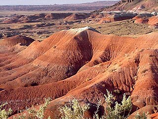
The Painted Desert is a United States desert of badlands in the Four Corners area, running from near the east end of Grand Canyon National Park and southeast into Petrified Forest National Park. It is most easily accessed from the north portion of Petrified Forest National Park. The Painted Desert is known for its brilliant and varied colors: these include the more common red rock, but also shades of lavender.

<span class="mw-page-title-main">Oregon Coast</span> Coastal region of the U.S. state of Oregon

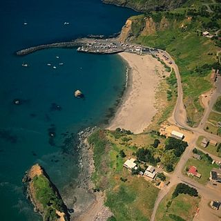
The Oregon Coast is a coastal region of the U.S. state of Oregon. It is bordered by the Pacific Ocean to its west and the Oregon Coast Range to the east, and stretches approximately 362 miles (583 km) from the California state border in the south to the Columbia River in the north. The region is not a specific geological, environmental, or political entity, and includes the Columbia River Estuary.

<span class="mw-page-title-main">Humbug Mountain</span>

Humbug Mountain is one of the highest mountains in the U.S. state of Oregon to rise directly from the Pacific Ocean. It lies on the state's southern coast, about 6 miles (10 km) south of Port Orford and 21 miles (34 km) north of Gold Beach. The mountain is completely within Humbug Mountain State Park, and U.S. Route 101 passes by its northern base. Its slopes feature an old-growth temperate rainforest. Two trails run from the state park campground to the mountain's summit, one 1.5 miles (2.4 km) long, the other 2 miles (3.2 km) long. Both are part of the much longer Oregon Coast Trail. The area is popular with hikers, campers, cyclists, and whale watchers although biking and camping on the mountain itself are prohibited.

<span class="mw-page-title-main">Elk River (Oregon)</span> River in Oregon, United States

The Elk River is in southwestern Oregon in the United States. About 29 miles (47 km) long, the river drains a remote 92-square-mile (240 km2) area of the Coast Range into the Pacific Ocean.

<span class="mw-page-title-main">Sixes River</span> River in the United States

The Sixes River flows about 31 miles (50 km) through coastal forests in southwestern Oregon in the United States. It drains a rugged region of the Klamath Mountains along the Pacific north of Port Orford.

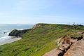
The Heads is a rocky cape on the Pacific Ocean coast of southwestern Oregon in the United States. It is located in northern Curry County, just outside the town of Port Orford, along a mountainous stretch of coast bounded to the east by the Coastal Range. The cape is part of Port Orford Heads State Park.

<span class="mw-page-title-main">Oswald West State Park</span> State park in Oregon, United States

Oswald West State Park is part of the state park system of the U.S. state of Oregon. It is located about 10 miles (16 km) south of the city of Cannon Beach, adjacent to Arch Cape, on the Pacific Ocean. The park covers 2,448 acres (9.91 km2), with many miles of hiking trails both inside the park grounds and linking to other parks and landmarks beyond.

<span class="mw-page-title-main">Heceta Head</span> Coastal headland in Oregon, United States

Heceta Head is a headland that stands 1,000 feet (300 m) above the Pacific Ocean in Lane County, Oregon, United States. The Heceta Head Light is located on its south side. Heceta Head is named after a Basque explorer under Spanish commission, Bruno de Heceta, who explored the Pacific Northwest in the 1770s. The headland marks the end of a lower-lying stretch of the coastline to the south dominated by sand dunes; the coastline to the north is more varied. Devils Elbow is the bay south of the headland at the mouth of Cape Creek, and with the headland formed Devils Elbow State Park, which is now part of Heceta Head Lighthouse State Scenic Viewpoint.

<span class="mw-page-title-main">Port Orford Heads State Park</span> State park in Oregon, United States

Port Orford Heads State Park is a coastal state park in northwest Curry County, Oregon, United States, in the city of Port Orford. Established in 1976, it is administered by the Oregon Parks and Recreation Department.

<span class="mw-page-title-main">Hug Point State Recreation Site</span> State park in Oregon, United States

Hug Point State Recreation Site is a state park on the northern Oregon Coast in the U.S. state of Oregon. Administered by the Oregon Parks and Recreation Department, the park is open to the public and is fee-free. Amenities at the park, which is 5 miles (8.0 km) south of Cannon Beach along U.S. Route 101, include picnicking, fishing, and a Pacific Ocean beach.

<span class="mw-page-title-main">Bandon State Natural Area</span>

Bandon State Natural Area is a state park in the U.S. state of Oregon. It is administered by the Oregon Parks and Recreation Department. The 879-acre (356 ha) park lies west of U.S. Route 101, off Beach Loop Drive, about 5 miles (8 km) south of Bandon. The Oregon Coast Trail passes through the park.

<span class="mw-page-title-main">Driftwood Beach State Recreation Site</span>

Driftwood Beach State Recreation Site is a state park administered by the Oregon Parks and Recreation Department in the U.S. state of Oregon. Located 3 miles (5 km) north of Waldport along the Pacific Ocean, the park offers beach access, picnicking, and fishing in a setting of shore pines and sand. It is fee-free and open year-round.

<span class="mw-page-title-main">Face Rock State Scenic Viewpoint</span>

Face Rock State Scenic Viewpoint is a state park in Bandon, Oregon, United States, administered by the Oregon Parks and Recreation Department. The rocks and tidal flats adjacent to the park form part of the Oregon Islands National Wildlife Refuge. More than 300 species of birds frequent the area.

<span class="mw-page-title-main">Humbug Mountain State Park</span> State park in Oregon, United States

Humbug Mountain State Park is a state park located on the Oregon coast. It is administered by the Oregon Parks and Recreation Department. The park can be accessed via the US Route 101, 6 miles (10 km) south of Port Orford, and 28 miles (45 km) north of Gold Beach. It covers 1,842 acres (7.45 km2) of land around 1,759-foot (536 m) Humbug Mountain, one of the tallest headlands on the Oregon coast.

<span class="mw-page-title-main">Manhattan Beach State Recreation Site</span>

Manhattan Beach State Recreation Site is a state park in the U.S. state of Oregon. Administered by the Oregon Parks and Recreation Department, the park is open to the public and is fee-free. Amenities at the park, which is 2 miles (3 km) north of Rockaway Beach along U.S. Route 101, include picnicking, fishing, and a Pacific Ocean beach.

<span class="mw-page-title-main">Oceanside Beach State Recreation Site</span> State park in Oregon, United States

Oceanside Beach State Recreation Site is a state park in the U.S. state of Oregon. Administered by the Oregon Parks and Recreation Department, the park is open to the public and is fee-free. Amenities at the site, in the unincorporated community of Oceanside, include picnicking, wildlife watching, fishing, windsurfing, and kite flying. It is not uncommon to see paraglider pilots land at the beach on Southwest wind days during the fall, winter and spring. Beachcombing is popular in summer, and agate hunting is best in winter, when ocean currents remove sand. Oceanside is about 11 miles (18 km) west of Tillamook off U.S. Route 101.

<span class="mw-page-title-main">Sunset Bay State Park</span> State park in Oregon, United States

Sunset Bay State Park is a state park in the U.S. state of Oregon. Administered by the Oregon Parks and Recreation Department, it is about 0.4 miles (0.6 km) south of Cape Arago Lighthouse and 2.5 miles (4.0 km) outside the town of Charleston on Coos Bay. The park offers a crescent shaped beach, tide pools, hiking trails and a year-round campground.

<span class="mw-page-title-main">Floras Lake</span> Lake in the U.S. state of Oregon

Floras Lake is a natural 236-acre (96 ha) body of water on the southern Oregon Coast of the United States. Fed by four small tributaries from a basin of about 10 square miles (26 km2) in Curry County, it lies about 10 miles (16 km) north of Port Orford and 2 miles (3 km) west of U.S. Route 101. It was probably named for Fred Flora, a 19th-century settler and miner who lived nearby.

References

  1. "Cape Blanco State Park". Geographic Names Information System. United States Geological Survey. May 22, 1986. Retrieved November 26, 2014.
  2. "Cape Blanco State Park: History". Oregon Parks and Recreation Department. Retrieved November 26, 2014.
  3. 1 2 3 4 5 6 7 8 Bannan, Jan (2002). Oregon State Parks: A Complete Recreation Guide (2nd ed.). Seattle: The Mountaineers Books. pp. 37–38. ISBN   0-89886-794-0.
  4. 1 2 3 4 5 LaLande, Jeff. "Cape Blanco". The Oregon Encyclopedia . Retrieved April 28, 2014.
  5. McArthur, Lewis A.; McArthur, Lewis L. (2003) [1928]. Oregon Geographic Names (7th ed.). Portland, Oregon: Oregon Historical Society Press. pp. 159–160. ISBN   978-0875952772.
  6. 1 2 Bishop, Ellen Morris; Eliot, John (1996). Hiking Oregon's Geology. Seattle: The Mountaineers. p. 52. ISBN   0-89886-485-2.
  7. "Booklet Chart: Port Orford to Cape Blanco" (PDF). National Oceanic and Atmospheric Administration. p. 2. Archived from the original (PDF) on December 19, 2014. Retrieved November 27, 2014.
  8. 1 2 Oregon Road and Recreation Atlas (5th ed.). Santa Barbara, California: Benchmark Maps. 2012. p. 82. ISBN   978-0-929591-62-9.
  9. Palmer, Tim (2014). Field Guide to Oregon Rivers. Corvallis: Oregon State University Press. p. 114. ISBN   978-0-87071-627-0.
  10. "CAPE BLANCO, OREGON (351360)". Western Regional Climate Center. Retrieved November 16, 2015.