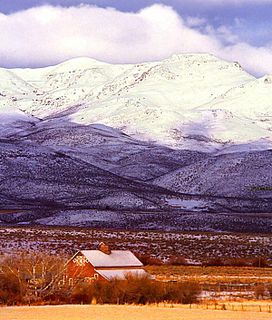
Owyhee County is a county in the southwestern corner of the U.S. state of Idaho. As of the 2010 census, the population was 11,526. The county seat is Murphy, and its largest city is Homedale. In area it is the second-largest county in Idaho, behind Idaho County.
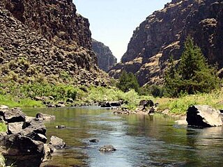
The Bruneau River is a 153-mile-long (246 km) tributary of the Snake River, in the U.S. states of Idaho and Nevada. It runs through a narrow canyon cut into ancient lava flows in southwestern Idaho. The Bruneau Canyon, which is up to 1,200 feet (370 m) deep and 40 miles (64 km) long, features rapids and hot springs, making it a popular whitewater trip.
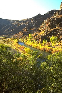
The Owyhee River is a tributary of the Snake River located in northern Nevada, southwestern Idaho and southeastern Oregon in the United States. It is 280 miles (450 km) long. The river's drainage basin is 11,049 square miles (28,620 km2) in area, one of the largest subbasins of the Columbia Basin. The mean annual discharge is 995 cubic feet per second (28.2 m3/s), with a maximum of 50,000 cu ft/s (1,400 m3/s) recorded in 1993 and a minimum of 42 cu ft/s (1.2 m3/s) in 1954.

The Owyhee Desert ecoregion, within the deserts and xeric shrublands biome, is in the Northwestern United States. The Owyhee Uplands Byway passes through the desert.

The Yellowstone hotspot is a volcanic hotspot in the United States responsible for large scale volcanism in Idaho, Montana, Nevada, Oregon, and Wyoming, formed as the North American tectonic plate moved over it. It formed the eastern Snake River Plain through a succession of caldera-forming eruptions. The resulting calderas include the Island Park Caldera, the Henry's Fork Caldera, and the Bruneau-Jarbidge caldera. The hotspot currently lies under the Yellowstone Caldera. The hotspot's most recent caldera-forming supereruption, known as the Lava Creek eruption, took place 640,000 years ago and created the Lava Creek Tuff, and the most recent Yellowstone Caldera. The Yellowstone hotspot is one of a few volcanic hotspots underlying the North American tectonic plate; another example is the Anahim hotspot.

The Hells Canyon Wilderness is a wilderness area in the western United States, in Idaho and Oregon. Created 46 years ago in 1975, the Wilderness is managed by both the U.S. Bureau of Land Management and the U.S. Forest Service and contains some of the most spectacular sections of the Snake River as it winds its way through Hells Canyon, North America's deepest river gorge and one of the deepest gorges on Earth. The Oregon Wilderness Act of 1984 added additional acreage and currently the area protects a total area of 217,927 acres (88,192 ha). It lies entirely within the Hells Canyon National Recreation Area except for a small 946-acre (383 ha) plot in southeastern Wallowa County, Oregon which is administered by the Bureau of Land Management. The area that is administered by the Forest Service consists of portions of the Wallowa, Nez Perce, Payette, and Whitman National Forests.

The Jarbidge River is a 51.8-mile-long (83.4 km), high elevation river in Elko County, Nevada and Owyhee County, Idaho in the United States. The Jarbidge originates as two main forks in the Jarbidge Mountains of northeastern Nevada and then flows through basalt and rhyolite canyons on the high plateau of the Owyhee Desert before joining the Bruneau River.

The Blue Mountains ecoregion is a Level III ecoregion designated by the United States Environmental Protection Agency (EPA) in the Pacific Northwest, mainly in the state of Oregon, with small areas over the state border in Idaho and southeastern Washington. It is also contiguous with the World Wildlife Fund's Blue Mountain forests ecoregion.

The Columbia Plateau ecoregion is a Level III ecoregion designated by the United States Environmental Protection Agency (EPA) encompassing approximately 32,100 square miles (83,139 km2) of land within the U.S. states of Washington, Oregon, and Idaho. The ecoregion extends across a wide swath of the Columbia River Basin from The Dalles, Oregon to Lewiston, Idaho to Okanogan, Washington near the Canada–US border. It includes nearly 500 miles (800 km) of the Columbia River, as well as the lower reaches of major tributaries such as the Snake and Yakima rivers and the associated drainage basins. It is named for the Columbia River Plateau, a flood basalt plateau formed by the Columbia River Basalt Group during the late Miocene and early Pliocene. The arid sagebrush steppe and grasslands of the region are flanked by moister, predominantly forested, mountainous ecoregions on all sides. The underlying basalt is up to 2 miles (3 km) thick and partially covered by thick loess deposits. Where precipitation amounts are sufficient, the deep loess soils have been extensively cultivated for wheat. Water from the Columbia River is subject to resource allocation debates involving fisheries, navigation, hydropower, recreation, and irrigation, and the Columbia Basin Project has dramatically converted much of the region to agricultural use.

The Omnibus Public Land Management Act of 2009 is a land management law passed in the 111th United States Congress and signed into law by President Barack Obama on March 30, 2009. The bill designates millions of acres in the US as protected and establishes a National Landscape Conservation System. It includes funding for programs, studies and other activities by the Department of the Interior and the Department of Agriculture, and in some cases bars further geothermal leasing, oil and gas leasing, and new mining patents on certain stretches of protected land.

The Bruneau – Jarbidge Rivers Wilderness is located on the high basalt plateaus of Owyhee County in southwestern Idaho in the western United States. The wilderness area is named after and protects much of the Bruneau and Jarbidge Rivers and their canyons. Whitewater rafting is a popular recreational activity in this wilderness area, which has rivers up to Class V. About 40 miles (64 km) of the Bruneau River and about 28.8 miles (46.3 km) of the Jarbidge River are classified as a wild river.

The Owyhee River Wilderness is located on the high basalt plateaus of Owyhee County in southwestern Idaho in the western United States. The wilderness area is named after and protects the upper Owyhee River, its tributaries, and the surrounding desert canyon landscape. Whitewater rafting is a popular recreational activity in this wilderness area. Managed by the Bureau of Land Management, it is the second-largest U.S. Wilderness Area that is not located within a National Forest, National Park, or National Wildlife Refuge. The BLM's Black Rock Desert Wilderness, located within Black Rock Desert – High Rock Canyon Emigrant Trails National Conservation Area, is larger. About 67.3 miles (108.3 km) of the Owyhee River is classified as a wild river.
Dickshooter is the name of a trailmarker and also of at least three geographical features in Owyhee County, Idaho: a ridge, a reservoir, and a creek. These are in close proximity to each other in the southwestern corner of the state, in a wilderness area approximately 24 miles (39 km) northwest of Riddle.
The North Fork Owyhee Wilderness is on the high basalt plateaus of Owyhee County in southwestern Idaho in the western United States. The rivers within it offer whitewater rapids up to Class IV. The upper 20.8 miles (33.5 km) of the North Fork Owyhee River, from the Idaho–Oregon border to the upstream boundary of the wilderness, are part of the National Wild and Scenic Rivers System. Of this total, 15.1 miles (24.3 km) are classified as wild and the remaining 5.7 miles (9.2 km) are classified "recreational".

The Big Jacks Creek Wilderness is located on the high basalt plateaus of Owyhee County in southwestern Idaho in the western United States. Little Jacks Creek Wilderness is on its northwest border. About 35 miles (56 km) of Big Jacks Creek is classified as a wild river.

The Little Jacks Creek Wilderness is located on the high basalt plateaus of Owyhee County in southwestern Idaho in the western United States. Big Jacks Creek Wilderness is on its southeast border. About 12.4 miles (20.0 km) of Little Jacks Creek is classified as a wild river.

The Dominguez–Escalante National Conservation Area is a 209,610-acre (848.3 km2) National Conservation Area located in western Colorado southeast of Grand Junction and northwest of Montrose. It is managed by the Bureau of Land Management (BLM), and was created as part of the Omnibus Public Land Management Act of 2009. In 2009 66,280 acres (26,820 ha) were also designated as the Dominguez Canyon Wilderness.

Battle Creek is a 67-mile (110 km) long tributary of the Owyhee River. Beginning at an elevation of 6,704 feet (2,043 m) in central Owyhee County, Idaho, it flows generally south through the Owyhee Desert to its mouth west of Riddle, at an elevation of 4,636 feet (1,413 m). In 2009, 23.4 miles (37.7 km) of the creek were designated as wild by the Omnibus Public Land Management Act, which also created the Owyhee River Wilderness.

Sheep Creek is a 63-mile (101 km) long tributary of the Bruneau River. Beginning at an elevation of 6,126 feet (1,867 m) east of Owyhee in northern Elko County, Nevada, it flows generally north into Owyhee County, Idaho and the Owyhee Desert, where it is roughly paralleled by Idaho State Highway 51. It then flows to its mouth in the Bruneau – Jarbidge Rivers Wilderness, at an elevation of 3,415 feet (1,041 m). In 2009, 25.6 miles (41.2 km) of the creek were designated as wild by the Omnibus Public Land Management Act, which also created the Bruneau – Jarbidge Rivers Wilderness.

The North Fork Owyhee River is a tributary, about 30 miles (48 km) long, of the Owyhee River in Malheur County, Oregon, and Owyhee County, Idaho, in the United States. It begins on the east flank of the Owyhee Mountains in Idaho and flows generally southwest to meet the main stem at Three Forks, Oregon, 161 miles (259 km) above the confluence of the larger river with the Snake River.

