Lake County, Montana

Last updated

Lake County
StIgMissionOutside.JPG
Map of Montana highlighting Lake County.svg
Location within the U.S. state of Montana
Montana in United States.svg
Montana's location within the U.S.
Coordinates: 47°39′N114°05′W / 47.65°N 114.09°W / 47.65; -114.09
CountryFlag of the United States.svg United States
StateFlag of Montana.svg  Montana
Founded1923
Named for Flathead Lake
Seat Polson
Largest cityPolson
Area
  Total1,654 sq mi (4,280 km2)
  Land1,490 sq mi (3,900 km2)
  Water164 sq mi (420 km2)  9.9%
Population
 (2020)
  Total31,134
  Estimate 
(2022)
32,853 Increase2.svg
  Density19/sq mi (7.3/km2)
Time zone UTC−7 (Mountain)
  Summer (DST) UTC−6 (MDT)
Congressional district 1st
Website www.lakemt.gov
  • Montana county number 15

Lake County is a county located in the northwest part of the U.S. state of Montana. As of the 2020 census, the population was 31,134. [1] Its county seat is Polson. [2]

Contents

Geography

According to the United States Census Bureau, the county has a total area of 1,654 square miles (4,280 km2), of which 1,490 square miles (3,900 km2) is land and 164 square miles (420 km2) (9.9%) is water. [3] Over two-thirds (67.7%) of the county's land lies within the Flathead Indian Reservation.

Adjacent counties

National protected areas

Demographics

Historical population
CensusPop.Note
1930 9,541
1940 13,49041.4%
1950 13,8352.6%
1960 13,104−5.3%
1970 14,44510.2%
1980 19,05631.9%
1990 21,04110.4%
2000 26,50726.0%
2010 28,7468.4%
2020 31,1348.3%
2022 (est.)32,853 [4] 5.5%
U.S. Decennial Census [5]
1790–1960, [6] 1900–1990, [7]
1990–2000, [8] 2010–2020 [1]

2020 census

As of the 2020 census, there were 31,134 people living in the county.[ citation needed ]

2010 census

As of the 2010 census, there were 28,746 people, 11,432 households, and 7,770 families living in the county. The population density was 19.3 inhabitants per square mile (7.5/km2). There were 16,588 housing units at an average density of 11.1 per square mile (4.3/km2). The racial makeup of the county was 69.4% white, 22.0% American Indian, 0.4% Asian, 0.3% black or African American, 0.1% Pacific islander, 0.5% from other races, and 7.3% from two or more races. Those of Hispanic or Latino origin made up 3.5% of the population. In terms of ancestry, 22.3% were German, 11.6% were English, 11.5% were Irish, 6.9% were Norwegian, and 3.8% were American.

Of the 11,432 households, 31.0% had children under the age of 18 living with them, 51.0% were married couples living together, 11.5% had a female householder with no husband present, 32.0% were non-families, and 26.5% of all households were made up of individuals. The average household size was 2.46 and the average family size was 2.97. The median age was 41.3 years.

The median income for a household in the county was $37,274 and the median income for a family was $47,437. Males had a median income of $37,461 versus $26,637 for females. The per capita income for the county was $20,164. About 15.4% of families and 21.6% of the population were below the poverty line, including 33.9% of those under age 18 and 9.3% of those age 65 or over.

Politics

United States presidential election results for Lake County, Montana [9]
Year Republican Democratic Third party
No.%No.%No.%
2020 9,32256.07%6,91641.60%3882.33%
2016 7,53057.13%4,77636.23%8756.64%
2012 7,13553.63%5,80543.63%3642.74%
2008 6,49846.56%6,76648.48%6924.96%
2004 7,24557.61%4,96039.44%3712.95%
2000 6,44156.26%3,88433.93%1,1239.81%
1996 4,72343.57%4,19538.70%1,92217.73%
1992 3,59634.08%3,93837.32%3,01828.60%
1988 4,88353.37%4,10944.91%1581.73%
1984 5,75461.55%3,47337.15%1211.29%
1980 5,08359.58%2,61530.65%8349.77%
1976 3,80952.83%3,25345.12%1482.05%
1972 4,17262.09%2,26033.64%2874.27%
1968 3,35855.98%1,95632.61%68511.42%
1964 2,82847.24%3,14852.59%100.17%
1960 3,24056.75%2,46243.12%70.12%
1956 3,36359.88%2,25340.12%00.00%
1952 3,65165.09%1,89333.75%651.16%
1948 2,29549.35%2,17746.82%1783.83%
1944 2,26555.80%1,75043.11%441.08%
1940 2,71852.46%2,37945.92%841.62%
1936 1,40131.68%2,65660.06%3658.25%
1932 1,36133.34%2,51461.59%2075.07%
1928 1,87659.42%1,25639.78%250.79%
1924 88428.00%34010.77%1,93361.23%

Communities

Cities

Town

Census-designated places

Unincorporated communities

Education

School districts include:

K-12 (Unified): [16]

High school: [16]

Elementary school: [16]

See also

Related Research Articles

<span class="mw-page-title-main">Ravalli County, Montana</span> County in Montana, United States

Ravalli County is a county in the southwestern part of the U.S. state of Montana. As of the 2020 census, the population was 44,174. Its county seat is Hamilton.

<span class="mw-page-title-main">Powell County, Montana</span> County in Montana, United States

Powell County is a county in the U.S. state of Montana. As of the 2020 census, the population was 6,946. Its county seat is Deer Lodge.

<span class="mw-page-title-main">Pondera County, Montana</span> County in Montana, United States

Pondera County is a county in the U.S. state of Montana. As of the 2020 census, the population was 5,898. Its county seat is Conrad.

<span class="mw-page-title-main">Missoula County, Montana</span> County in Montana, United States

Missoula County is located in the State of Montana. As of the 2020 census, the population was 117,922, making it Montana's third most populous county. Its county seat and most populous city is Missoula. The county was founded in 1860.

<span class="mw-page-title-main">Lincoln County, Montana</span> County in Montana, United States

Lincoln County is a county located in the U.S. state of Montana. As of the 2020 census, the population was 19,677. Its county seat is Libby. The county was founded in 1909 and named for President Abraham Lincoln. The county lies on Montana's north border and thus shares the US-Canadian border with the Canadian province of British Columbia.

<span class="mw-page-title-main">Lewis and Clark County, Montana</span> County in Montana, United States

Lewis and Clark County is a county located in the U.S. state of Montana. As of the 2020 census, the population was 70,973. Its county seat is Helena, the state capital. The numerical designation for Lewis and Clark County is 5. The county was established on June 2, 1865, as one of the nine original counties of the Territory of Montana named Edgerton County in honor of Sidney Edgerton, first Governor of the Territory of Montana, and was renamed Lewis and Clark County on March 1, 1868, in honor of explorers Meriwether Lewis and William Clark.

<span class="mw-page-title-main">Glacier County, Montana</span> County in Montana, United States

Glacier County is located in the U.S. state of Montana. As of the 2020 census, the population was 13,778. The county is located in northwestern Montana between the Great Plains and the Rocky Mountains, known to the Blackfeet as the "Backbone of the World". The county is geographically and culturally diverse and includes the Blackfeet Indian Reservation, Glacier National Park, and Lewis and Clark National Forest. The county is bordered by 75 miles of international boundary with two ports of entry open year-round and one seasonal international border crossing into Alberta, Canada.

<span class="mw-page-title-main">Flathead County, Montana</span> County in Montana, United States

Flathead County is in the U.S. state of Montana. At the 2020 census, its population was 104,357, making it the state's fourth most populous county. Its county seat is Kalispell. Its numerical designation is 7. Its northern border is on the state's north border, making it contiguous with the Canada–US border, facing British Columbia.

<span class="mw-page-title-main">Bigfork, Montana</span> Unincorporated community in Montana, United States

Bigfork is a census-designated place (CDP) in Flathead County, Montana, United States. It is within Montana's Rocky Mountains. The population was 5,118 at the 2020 census, up from 4,270 in 2010.

<span class="mw-page-title-main">Columbia Falls, Montana</span> City in Montana, United States

Columbia Falls is a city along the Flathead River in Flathead County, Montana, United States. The population was 5,308 at the 2020 census. Columbia Falls has been ranked as one of the best and safest places to live in Montana.

<span class="mw-page-title-main">Kalispell, Montana</span> City in Montana, United States

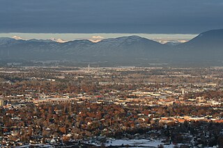
Kalispell is a city in Montana and the county seat of Flathead County, Montana, United States. The 2020 census put Kalispell's population at 24,558. In Montana's northwest region, it is the largest city and the commercial center of the Kalispell Micropolitan Statistical Area. The name Kalispell is a Salish word meaning "flat land above the lake".

<span class="mw-page-title-main">Charlo, Montana</span> Census-designated place in Montana, United States

Charlo is an unincorporated community and census-designated place (CDP) in Lake County, Montana, United States. The population was 385 at the 2020 census.

<span class="mw-page-title-main">Finley Point, Montana</span> Census-designated place in Montana, United States

Finley Point is a census-designated place (CDP) in Lake County, Montana, United States. As of the 2010 census the population was 480.

<span class="mw-page-title-main">St. Ignatius, Montana</span> Town in Montana, United States

St. Ignatius is a town in Lake County, Montana, United States. The population was 768 at the 2020 census. The town is located on the Flathead Indian Reservation.

<span class="mw-page-title-main">Evaro, Montana</span> CDP in Montana, United States

Evaro is a census-designated place (CDP) in Missoula County, Montana, United States, and part of the Missoula Metropolitan Statistical Area. It is located on the southernmost tip of the Flathead Indian Reservation, approximately 12 miles (19 km) north of downtown Missoula and is served by US Highway 93. In 2010, Evaro had a population of 322, a decrease from 329 in 2000.

<span class="mw-page-title-main">Arlee, Montana</span> Census-designated place in Montana, United States

Arlee is an unincorporated community and census-designated place (CDP) on the Flathead Reservation, Lake County, Montana, United States. The population was 725 at the 2020 census. It is named after Alee, a Salish chief. The chief's name has no "r", as the Salish alphabet has no letter "r".

<span class="mw-page-title-main">Dayton, Montana</span> Census-designated place in Montana, United States

Dayton is an unincorporated community and census-designated place (CDP) in Lake County, Montana, United States. The population was 84 at the 2010 census.

<span class="mw-page-title-main">Pablo, Montana</span> Census-designated place in Montana, United States

Pablo is a census-designated place (CDP) in Lake County, Montana, United States. The population was 2,138 at the 2020 census. It is the home of Salish Kootenai College and the seat of government of the Flathead Indian Reservation.

<span class="mw-page-title-main">Polson, Montana</span> Town in Montana, United States

Polson is a city in , United States, on the southern shore of Flathead Lake and within the Flathead Indian Reservation. The population was 5,148 at the 2020 census. It is the county seat of Lake County. In 1898 the city was named after pioneer rancher David Polson. It was incorporated in 1910.

<span class="mw-page-title-main">Ronan, Montana</span> City in Montana, United States

Ronan is a city in Lake County, Montana, United States. It is on the Flathead Indian Reservation. The population was 1,955 at the 2020 census.

References

  1. 1 2 "State & County QuickFacts". United States Census Bureau. Retrieved April 5, 2023.
  2. "Find a County". National Association of Counties. Retrieved June 7, 2011.
  3. "2010 Census Gazetteer Files". United States Census Bureau. August 22, 2012. Archived from the original on December 5, 2014. Retrieved November 28, 2014.
  4. "Annual Estimates of the Resident Population for Counties: April 1, 2020 to July 1, 2022". United States Census Bureau. Retrieved April 5, 2023.
  5. "U.S. Decennial Census". United States Census Bureau. Retrieved November 28, 2014.
  6. "Historical Census Browser". University of Virginia Library. Retrieved November 28, 2014.
  7. "Population of Counties by Decennial Census: 1900 to 1990". United States Census Bureau. Retrieved November 28, 2014.
  8. "Census 2000 PHC-T-4. Ranking Tables for Counties: 1990 and 2000" (PDF). United States Census Bureau. Archived (PDF) from the original on March 27, 2010. Retrieved November 28, 2014.
  9. Leip, David. "Atlas of US Presidential Elections". uselectionatlas.org. Retrieved April 3, 2018.
  10. Allentown MT Google Maps (accessed January 2, 2019)
  11. Post Creek MT Google Maps (accessed January 2, 2019)
  12. Proctor MT Google Maps (accessed January 2, 2019)
  13. Round Butte MT Google Maps (accessed January 2, 2019)
  14. Salmon Prairie Google Maps (accessed January 2, 2019)
  15. Sipes MT Google Maps (accessed January 2, 2019)
  16. 1 2 3 "2020 CENSUS - SCHOOL DISTRICT REFERENCE MAP: Lake County, MT" (PDF). U.S. Census Bureau. p. 4 (PDF p. 5/7). Retrieved March 13, 2024. - Text list

47°39′N114°05′W / 47.65°N 114.09°W / 47.65; -114.09