McCone County, Montana

Last updated

McCone County
Gladstone Hotel (2013).jpg
Map of Montana highlighting McCone County.svg
Location within the U.S. state of Montana
Montana in United States.svg
Montana's location within the U.S.
Coordinates: 47°39′N105°48′W / 47.65°N 105.8°W / 47.65; -105.8
CountryFlag of the United States.svg United States
StateFlag of Montana.svg  Montana
Founded1919
Seat Circle
Largest townCircle
Area
  Total2,683 sq mi (6,950 km2)
  Land2,643 sq mi (6,850 km2)
  Water40 sq mi (100 km2)  1.5%
Population
 (2020)
  Total1,729
  Estimate 
(2022)
1,709 Decrease2.svg
  Density0.64/sq mi (0.25/km2)
Time zone UTC−7 (Mountain)
  Summer (DST) UTC−6 (MDT)
Congressional district 2nd
Website mcconecountymt.com
  • Montana county number 41

McCone County is a county located in the U.S. state of Montana. As of the 2020 census, the population was 1,729. [1] Its county seat is Circle. [2]

Contents

The county was created in 1919. It was named for State Senator George McCone, [3] who had been one of the first county commissioners of Dawson County. [4]

Geography

Typical McCone County landscape. McCone Geography.jpg
Typical McCone County landscape.

According to the United States Census Bureau, the county has a total area of 2,683 square miles (6,950 km2), of which 2,643 square miles (6,850 km2) is land and 40 square miles (100 km2) (1.5%) is water. [5]

Major highways

Adjacent counties

National protected area

Demographics

Historical population
CensusPop.Note
1920 4,747
1930 4,7900.9%
1940 3,744−21.8%
1950 3,258−13.0%
1960 3,3211.9%
1970 2,875−13.4%
1980 2,702−6.0%
1990 2,276−15.8%
2000 1,977−13.1%
2010 1,734−12.3%
2020 1,729−0.3%
2022 (est.)1,709 [6] −1.2%
U.S. Decennial Census [7]
1790–1960, [8] 1900–1990, [9]
1990–2000, [10] 2010–2020 [1]

2020 census

As of the 2020 census, there were 1,729 people living in the county.[ citation needed ]

2010 census

As of the 2010 census, there were 1,734 people, 774 households, and 514 families living in the county. The population density was 0.7 inhabitants per square mile (0.27 inhabitants/km2), the 10th lowest in the United States. There were 1,008 housing units at an average density of 0.4 units per square mile (0.15 units/km2). The racial makeup of the county was 98.0% white, 0.4% American Indian, 0.1% black or African American, 0.1% Asian, 0.1% from other races, and 1.2% from two or more races. Those of Hispanic or Latino origin made up 0.7% of the population. In terms of ancestry, 44.5% were German, 23.1% were Norwegian, 12.7% were American, 12.0% were Irish, and 8.8% were English.

Of the 774 households, 23.4% had children under the age of 18 living with them, 61.0% were married couples living together, 3.2% had a female householder with no husband present, 33.6% were non-families, and 31.7% of all households were made up of individuals. The average household size was 2.22 and the average family size was 2.77. The median age was 48.9 years.

The median income for a household in the county was $48,167 and the median income for a family was $56,406. Males had a median income of $33,185 versus $26,454 for females. The per capita income for the county was $23,265. About 5.9% of families and 8.6% of the population were below the poverty line, including 10.3% of those under age 18 and 11.5% of those age 65 or over.

Communities

Looking south on MT 13 toward Vida. MThwy13.jpg
Looking south on MT 13 toward Vida.

Town

Census-designated places

Other unincorporated communities

Politics

McCone county is a solid Republican county. In the 2004 Presidential Election McCone County gave 69.6% of its votes to President George W. Bush and 28.1% to Senator John Kerry. In the 2012 presidential election Governor Mitt Romney received 75.0% of the county's votes, while President Barack Obama only received 22.5% of the votes.

United States presidential election results for McCone County, Montana [13]
Year Republican Democratic Third party
No.%No.%No.%
2020 95684.75%15513.74%171.51%
2016 86278.72%15414.06%797.21%
2012 74575.03%22322.46%252.52%
2008 72666.54%32129.42%444.03%
2004 79169.57%32028.14%262.29%
2000 82772.42%26723.38%484.20%
1996 61548.96%39031.05%25119.98%
1992 52839.00%42431.31%40229.69%
1988 81458.18%56740.53%181.29%
1984 1,01567.80%45930.66%231.54%
1980 1,00067.98%34923.73%1228.29%
1976 73048.70%74949.97%201.33%
1972 85458.29%56238.36%493.34%
1968 73352.17%58941.92%835.91%
1964 61540.81%89159.12%10.07%
1960 74349.04%76450.43%80.53%
1956 75245.83%88954.17%00.00%
1952 90056.32%67442.18%241.50%
1948 51837.78%70251.20%15111.01%
1944 52639.85%76357.80%312.35%
1940 52935.24%92861.83%442.93%
1936 33219.09%1,36678.55%412.36%
1932 45626.34%1,02058.93%25514.73%
1928 94661.87%55436.23%291.90%
1924 49438.18%14311.05%65750.77%
1920 1,17762.01%53728.29%1849.69%

See also

Related Research Articles

<span class="mw-page-title-main">Wibaux County, Montana</span> County in Montana, United States

Wibaux County is a county in the U.S. state of Montana. As of the 2020 census, the population was 937, making it the fourth-least populous county in Montana. Its county seat is Wibaux.

<span class="mw-page-title-main">Valley County, Montana</span> County in Montana, United States

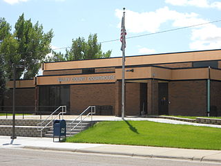
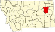
Valley County is a county in the U.S. state of Montana. Valley County was created in 1893 with area partitioned from Dawson County. As of the 2020 census, the population was 7,578. Its county seat is Glasgow. It is located on the Canada–United States border with Saskatchewan.

<span class="mw-page-title-main">Toole County, Montana</span> County in Montana, United States

Toole County is a county in the northern portion of the U.S. state of Montana. As of the 2020 census, the population was 4,971. Its county seat is Shelby. The county was established in 1914 from parts of Hill County and Teton County and was named after Joseph Toole, the first and fourth governor of Montana. Its northern boundary is the Canada–United States border south of Alberta.

<span class="mw-page-title-main">Stillwater County, Montana</span> County in Montana, United States

Stillwater County is a county in the U.S. state of Montana. As of the 2020 census, the population was 8,963. Its county seat is Columbus.

<span class="mw-page-title-main">Silver Bow County, Montana</span> County in Montana, United States

Silver Bow County is a county in the U.S. state of Montana. As of the 2020 census, the population was 35,133. Its county seat is Butte. In 1977, the city and county governments consolidated to form the single entity of Butte-Silver Bow. Additionally, the town of Walkerville is a separate municipality from Butte and is within the county.

<span class="mw-page-title-main">Roosevelt County, Montana</span> County in Montana, United States

Roosevelt County is a county in the U.S. state of Montana. As of the 2020 census, the population was 10,794. Its county seat is Wolf Point. Roosevelt County was created by the Montana Legislature in 1919 from a portion of Sheridan County. The name honors former president Theodore Roosevelt, who had died earlier that year.

<span class="mw-page-title-main">Richland County, Montana</span> County in Montana, United States

Richland County is a county in the U.S. state of Montana. As of the 2020 census, the population was 11,491. Its county seat is Sidney.

<span class="mw-page-title-main">Prairie County, Montana</span> County in Montana, United States

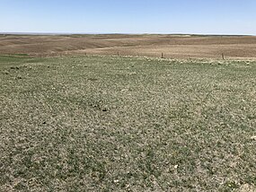
Prairie County is a county in the U.S. state of Montana. As of the 2020 census, the population was 1,088, making it the fifth-least populous county in Montana. Its county seat is Terry. Prairie County was created by the Montana Legislature in 1915 out of parts of Custer, Dawson, and Fallon Counties. The name was selected in a contest and reflects the predominant landscape of the region.

<span class="mw-page-title-main">Powder River County, Montana</span> County in Montana, United States

Powder River County is a county in the U.S. state of Montana. As of the 2020 census, the population was 1,694. Its county seat is Broadus.

<span class="mw-page-title-main">Phillips County, Montana</span> County in Montana, United States

Phillips County is a county in the U.S. state of Montana. As of the 2020 census, the population was 4,217. Its county seat is Malta. Before February 5, 1915, Phillips County was part of Blaine County, and before 1912 both were part of Chouteau County. It was named for rancher and state senator Benjamin D. Phillips.

<span class="mw-page-title-main">Park County, Montana</span> County in Montana, United States

Park County is a county in the U.S. state of Montana. At the 2020 census, the population was 17,191. Its county seat is Livingston. A small part of Yellowstone National Park is in the southern part of the county.

<span class="mw-page-title-main">Meagher County, Montana</span> County in Montana, United States

Meagher County is a county located in the U.S. state of Montana. As of the 2020 census, the population was 1,927. Its county seat is White Sulphur Springs.

<span class="mw-page-title-main">Madison County, Montana</span> County in Montana, United States

Madison County is a county in the U.S. state of Montana. As of the 2020 census, the population was 8,623. Its county seat is Virginia City. The county was founded in 1865; at the time it was part of the Montana Territory.

<span class="mw-page-title-main">Lewis and Clark County, Montana</span> County in Montana, United States

Lewis and Clark County is a county located in the U.S. state of Montana. As of the 2020 census, the population was 70,973. Its county seat is Helena, the state capital. The numerical designation for Lewis and Clark County is 5. The county was established on June 2, 1865, as one of the nine original counties of the Territory of Montana named Edgerton County in honor of Sidney Edgerton, first Governor of the Territory of Montana, and was renamed Lewis and Clark County on March 1, 1868, in honor of explorers Meriwether Lewis and William Clark.

<span class="mw-page-title-main">Judith Basin County, Montana</span> County in Montana, United States

Judith Basin County is a county in the U.S. state of Montana. As of the 2020 census, the population was 2,023. Its county seat is the town of Stanford.

<span class="mw-page-title-main">Garfield County, Montana</span> County in Montana, United States

Garfield County is a county located in the U.S. state of Montana. As of the 2020 census, the population was 1,173. Its county seat is Jordan.

<span class="mw-page-title-main">Daniels County, Montana</span> County in Montana, United States

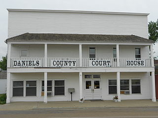
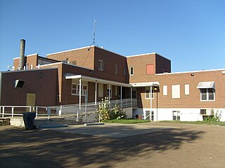
Daniels County is a county located in the U.S. state of Montana. As of the 2020 census, the population was 1,661. Its county seat is Scobey. It is on Montana's north border, and thus abuts the Canada–US border with Saskatchewan.

<span class="mw-page-title-main">Custer County, Montana</span> County in Montana, United States

Custer County is a county located in the U.S. state of Montana. As of the 2020 census, the population was 11,867. Its county seat is Miles City. The county was established on June 2, 1865, as one of the nine original counties of the Territory of Montana named Big Horn County, and was renamed on February 16, 1877, in honor of Lieutenant Colonel George Armstrong Custer.

<span class="mw-page-title-main">Carter County, Montana</span> County in Montana, United States

Carter County is a county located in the U.S. state of Montana. As of the 2020 census, the population was 1,415, making it the seventh-least populous county in Montana. The county seat is Ekalaka.

<span class="mw-page-title-main">Circle, Montana</span> Town in Montana, United States

Circle is a town in and the county seat of McCone County, Montana, United States. The population was 591 at the 2020 census.

References

  1. 1 2 "State & County QuickFacts". United States Census Bureau. Retrieved May 9, 2023.
  2. "Find a County". National Association of Counties. Archived from the original on May 31, 2011. Retrieved June 7, 2011.
  3. "McCone County - Home". www.mccone.mt.gov. Retrieved April 3, 2018.
  4. Bill Babcock (August 1987). "Montana Historical and Architectural Inventory: McCone Residence / Dobson Residence". National Park Service . Retrieved July 9, 2017. With two photos from 1987.
  5. "2010 Census Gazetteer Files". United States Census Bureau. August 22, 2012. Archived from the original on December 5, 2014. Retrieved November 29, 2014.
  6. "Annual Estimates of the Resident Population for Counties: April 1, 2020 to July 1, 2022". United States Census Bureau. Retrieved May 9, 2023.
  7. "U.S. Decennial Census". United States Census Bureau. Retrieved November 29, 2014.
  8. "Historical Census Browser". University of Virginia Library. Retrieved November 29, 2014.
  9. "Population of Counties by Decennial Census: 1900 to 1990". United States Census Bureau. Retrieved November 29, 2014.
  10. "Census 2000 PHC-T-4. Ranking Tables for Counties: 1990 and 2000" (PDF). United States Census Bureau. Archived (PDF) from the original on March 27, 2010. Retrieved November 29, 2014.
  11. Nickwall MT Google Maps (accessed January 3, 2019)
  12. Weldon MT Google Maps (accessed January 3, 2019)
  13. Leip, David. "Atlas of US Presidential Elections". uselectionatlas.org. Retrieved April 3, 2018.

47°39′N105°48′W / 47.65°N 105.80°W / 47.65; -105.80