Prairie County, Montana

Last updated

Prairie County
Typical.Snowday.Terry.JPG
Downtown Terry, Montana during a typical snowy day.
Map of Montana highlighting Prairie County.svg
Location within the U.S. state of Montana
Montana in United States.svg
Montana's location within the U.S.
Coordinates: 46°51′N105°22′W / 46.85°N 105.37°W / 46.85; -105.37
CountryFlag of the United States.svg United States
StateFlag of Montana.svg  Montana
FoundedFebruary 5, 1915
Named for Prairie landscape
Seat Terry
Largest townTerry
Area
  Total1,743 sq mi (4,510 km2)
  Land1,737 sq mi (4,500 km2)
  Water5.8 sq mi (15 km2)  0.3%
Population
 (2020)
  Total1,088
  Estimate 
(2022)
1,107 Increase2.svg
  Density0.6/sq mi (0.2/km2)
Time zone UTC−7 (Mountain)
  Summer (DST) UTC−6 (MDT)
Congressional district 2nd
Website visitterrymt.com (Terry Chamber of Commerce)
  • Montana county number 45

Prairie County is a county in the U.S. state of Montana. As of the 2020 census, the population was 1,088, [1] making it the fifth-least populous county in Montana.[ citation needed ] Its county seat is Terry. [2] Prairie County was created by the Montana Legislature in 1915 out of parts of Custer, Dawson, and Fallon Counties. The name was selected in a contest and reflects the predominant landscape of the region. [3]

Contents

The county was the site of the 1938 Custer Creek train wreck that killed 47 people and injured 75.

Geography

According to the United States Census Bureau, the county has a total area of 1,743 square miles (4,510 km2), of which 1,737 square miles (4,500 km2) is land and 5.8 square miles (15 km2) (0.3%) is water. [4]

Major highways

Adjacent counties

Demographics

Historical population
CensusPop.Note
1920 3,684
1930 3,9417.0%
1940 2,410−38.8%
1950 2,377−1.4%
1960 2,318−2.5%
1970 1,752−24.4%
1980 1,8364.8%
1990 1,383−24.7%
2000 1,199−13.3%
2010 1,179−1.7%
2020 1,088−7.7%
2022 (est.)1,107 [5] 1.7%
U.S. Decennial Census [6]
1790–1960, [7] 1900–1990, [8]
1990–2000, [9] 2010–2020 [1]

2020 census

As of the 2000 census, there were 1,088 people living in the county.[ citation needed ]

2010 census

As of the 2010 census, there were 1,179 people, 551 households, and 342 families in the county. The population density was 0.7 inhabitants per square mile (0.27/km2). There were 673 housing units at an average density of 0.4 per square mile (0.15/km2). The racial makeup of the county was 96.4% white, 0.5% Asian, 0.2% American Indian, 0.2% from other races, and 2.8% from two or more races. Those of Hispanic or Latino origin made up 1.4% of the population. In terms of ancestry, 44.7% were German, 18.6% were Norwegian, 14.1% were American, 11.8% were Irish, and 9.5% were English.

Of the 551 households, 18.5% had children under the age of 18 living with them, 55.9% were married couples living together, 4.2% had a female householder with no husband present, 37.9% were non-families, and 34.1% of all households were made up of individuals. The average household size was 2.10 and the average family size was 2.67. The median age was 53.6 years.

The median income for a household in the county was $34,896 and the median income for a family was $43,500. Males had a median income of $28,438 versus $21,964 for females. The per capita income for the county was $21,296. About 12.4% of families and 16.9% of the population were below the poverty line, including 34.6% of those under age 18 and 14.5% of those age 65 or over.

Politics

Voters in Prairie County have voted for Republican Party candidates in all national elections since 1948 (as of 2020).

United States presidential election results for Prairie County, Montana [10]
Year Republican Democratic Third party
No.%No.%No.%
2020 60381.05%12616.94%152.02%
2016 55680.70%10014.51%334.79%
2012 52073.97%16723.76%162.28%
2008 50368.44%21128.71%212.86%
2004 54674.18%18124.59%91.22%
2000 54172.52%16421.98%415.50%
1996 41753.46%25933.21%10413.33%
1992 41248.13%26030.37%18421.50%
1988 54160.11%34338.11%161.78%
1984 69369.93%28929.16%90.91%
1980 58062.57%28330.53%646.90%
1976 59758.59%41540.73%70.69%
1972 68568.57%30330.33%111.10%
1968 63567.77%27028.82%323.42%
1964 55552.96%48846.56%50.48%
1960 64965.75%33834.25%00.00%
1956 63761.25%40338.75%00.00%
1952 77169.21%33830.34%50.45%
1948 49947.89%52750.58%161.54%
1944 59855.68%46843.58%80.74%
1940 59751.42%55447.72%100.86%
1936 45433.31%87764.34%322.35%
1932 63445.71%73252.78%211.51%
1928 96870.20%40529.37%60.44%
1924 68356.21%16213.33%37030.45%
1920 88176.68%24221.06%262.26%
1916 53545.38%62252.76%221.87%

Communities

Town

Census-designated place

Other communities

See also

Related Research Articles

<span class="mw-page-title-main">Yellowstone County, Montana</span> County in Montana, United States

Yellowstone County is the most populous county in the U.S. state of Montana. As of the 2020 census, the population was 164,731. Its county seat is Billings, the state's most populous city. Like the nearby park, Yellowstone County is named after the Yellowstone River which roughly bisects the county, flowing southwest to northeast. The river, in turn, was named for the yellow sandstone cliffs in what is now Yellowstone County.

<span class="mw-page-title-main">Wibaux County, Montana</span> County in Montana, United States

Wibaux County is a county in the U.S. state of Montana. As of the 2020 census, the population was 937, making it the fourth-least populous county in Montana. Its county seat is Wibaux.

<span class="mw-page-title-main">Teton County, Montana</span> County in Montana, United States

Teton County is a county in the U.S. state of Montana. As of the 2020 census, the population was 6,226. Its county seat is Choteau. The county was founded in 1893.

<span class="mw-page-title-main">Sweet Grass County, Montana</span> County in Montana, United States

Sweet Grass County is a county located in the U.S. state of Montana. As of the 2020 census, the population was 3,678. Its county seat is Big Timber. The county was founded in 1895.

<span class="mw-page-title-main">Stillwater County, Montana</span> County in Montana, United States

Stillwater County is a county in the U.S. state of Montana. As of the 2020 census, the population was 8,963. Its county seat is Columbus.

<span class="mw-page-title-main">Roosevelt County, Montana</span> County in Montana, United States

Roosevelt County is a county in the U.S. state of Montana. As of the 2020 census, the population was 10,794. Its county seat is Wolf Point. Roosevelt County was created by the Montana Legislature in 1919 from a portion of Sheridan County. The name honors former president Theodore Roosevelt, who had died earlier that year.

<span class="mw-page-title-main">Richland County, Montana</span> County in Montana, United States

Richland County is a county in the U.S. state of Montana. As of the 2020 census, the population was 11,491. Its county seat is Sidney.

<span class="mw-page-title-main">Powder River County, Montana</span> County in Montana, United States

Powder River County is a county in the U.S. state of Montana. As of the 2020 census, the population was 1,694. Its county seat is Broadus.

<span class="mw-page-title-main">Pondera County, Montana</span> County in Montana, United States

Pondera County is a county in the U.S. state of Montana. As of the 2020 census, the population was 5,898. Its county seat is Conrad.

<span class="mw-page-title-main">Park County, Montana</span> County in Montana, United States

Park County is a county in the U.S. state of Montana. At the 2020 census, the population was 17,191. Its county seat is Livingston. A small part of Yellowstone National Park is in the southern part of the county.

<span class="mw-page-title-main">Mineral County, Montana</span> County in Montana, United States

Mineral County is a county located in the U.S. state of Montana. As of the 2020 census, the population was 4,535. Its county seat is Superior.

<span class="mw-page-title-main">McCone County, Montana</span> County in Montana, United States

McCone County is a county located in the U.S. state of Montana. As of the 2020 census, the population was 1,729. Its county seat is Circle.

<span class="mw-page-title-main">Lake County, Montana</span> County in Montana, United States

Lake County is a county located in the northwest part of the U.S. state of Montana. As of the 2020 census, the population was 31,134. Its county seat is Polson.

<span class="mw-page-title-main">Garfield County, Montana</span> County in Montana, United States

Garfield County is a county located in the U.S. state of Montana. As of the 2020 census, the population was 1,173. Its county seat is Jordan.

<span class="mw-page-title-main">Fallon County, Montana</span> County in Montana, United States

Fallon County is a county located in the U.S. state of Montana. As of the 2020 census, the population was 3,049. Its county seat is Baker. The county was created in 1913 from a portion of Custer County. It is named for Benjamin O'Fallon, a nephew of Captain William Clark and an Indian agent for the upper Missouri region from 1823 to 1827.

<span class="mw-page-title-main">Daniels County, Montana</span> County in Montana, United States

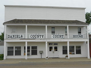
Daniels County is a county located in the U.S. state of Montana. As of the 2020 census, the population was 1,661. Its county seat is Scobey. It is on Montana's north border, and thus abuts the Canada–US border with Saskatchewan.

<span class="mw-page-title-main">Custer County, Montana</span> County in Montana, United States

Custer County is a county located in the U.S. state of Montana. As of the 2020 census, the population was 11,867. Its county seat is Miles City. The county was established on June 2, 1865, as one of the nine original counties of the Territory of Montana named Big Horn County, and was renamed on February 16, 1877, in honor of Lieutenant Colonel George Armstrong Custer.

<span class="mw-page-title-main">Chouteau County, Montana</span> County in Montana, United States

Chouteau County is a county located in the North-Central region of the U.S. state of Montana. As of the 2020 census, the population was 5,895. Its county seat is Fort Benton. The county was established in 1865 as one of the original nine counties of Montana, and named in 1882 after Pierre Chouteau Jr., a fur trader who established a trading post that became Fort Benton, which was once an important port on the Missouri River.

<span class="mw-page-title-main">Carter County, Montana</span> County in Montana, United States

Carter County is a county located in the U.S. state of Montana. As of the 2020 census, the population was 1,415, making it the seventh-least populous county in Montana. The county seat is Ekalaka.

<span class="mw-page-title-main">Terry, Montana</span> Town and county seat in Prairie County, Montana, US

Terry, incorporated in 1910, is a town and the county seat of Prairie County, Montana, United States. The population was 562 at the 2020 census.

References

  1. 1 2 "State & County QuickFacts". United States Census Bureau. Retrieved May 7, 2023.
  2. "Find a County". National Association of Counties. Retrieved June 7, 2011.
  3. "Montana Place Names Companion". Montana Place Names From Alzada to Zortman. Montana Historical Society Research Center. Retrieved May 9, 2011.
  4. "2010 Census Gazetteer Files". United States Census Bureau. August 22, 2012. Archived from the original on December 5, 2014. Retrieved November 29, 2014.
  5. "Annual Estimates of the Resident Population for Counties: April 1, 2020 to July 1, 2022". United States Census Bureau. Retrieved May 7, 2023.
  6. "U.S. Decennial Census". United States Census Bureau. Retrieved November 29, 2014.
  7. "Historical Census Browser". University of Virginia Library. Retrieved November 29, 2014.
  8. "Population of Counties by Decennial Census: 1900 to 1990". United States Census Bureau. Retrieved November 29, 2014.
  9. "Census 2000 PHC-T-4. Ranking Tables for Counties: 1990 and 2000" (PDF). United States Census Bureau. Archived (PDF) from the original on March 27, 2010. Retrieved November 29, 2014.
  10. Leip, David. "Atlas of US Presidential Elections". uselectionatlas.org. Retrieved April 3, 2018.
  11. Crow Rock MT Google Maps (accessed January 5, 2019)
  12. McCloud MT Google Maps (accessed January 5, 2019)

46°51′N105°22′W / 46.85°N 105.37°W / 46.85; -105.37