Liberty County, Montana

Last updated

Liberty County
Liberty County Courthouse2.JPG
Liberty County Courthouse in Chester
Map of Montana highlighting Liberty County.svg
Location within the U.S. state of Montana
Montana in United States.svg
Montana's location within the U.S.
Coordinates: 48°33′N111°02′W / 48.55°N 111.03°W / 48.55; -111.03
CountryFlag of the United States.svg United States
StateFlag of Montana.svg  Montana
FoundedFebruary 11, 1920 [1]
Named for Liberty
Seat Chester
Largest townChester
Area
  Total1,447 sq mi (3,750 km2)
  Land1,430 sq mi (3,700 km2)
  Water17 sq mi (40 km2)  1.2%
Population
 (2020)
  Total1,959
  Estimate 
(2022)
1,972 Increase2.svg
  Density1.4/sq mi (0.52/km2)
Time zone UTC−7 (Mountain)
  Summer (DST) UTC−6 (MDT)
Congressional district 2nd
Website www.co.liberty.mt.us
  • Montana county number 48

Liberty County is a county located in the U.S. state of Montana. As of the 2020 census, the population was 1,959. [2] Its county seat is Chester. [3] The decision to separate the future Liberty County area from the previous Hill and Chouteau counties was carried in a 1919 vote; the organization was authorized to commence in the following February. [1] [4]

Contents

The southwestern corner of Liberty County holds Tiber Dam, a popular tourist and recreation area.

Geography

Liberty County is on the state's north line, so that it shares the US border with Canada. It abuts the Canadian province of Alberta. According to the United States Census Bureau, the county has a total area of 1,447 square miles (3,750 km2), of which 1,430 square miles (3,700 km2) is land and 17 square miles (44 km2) (1.2%) is water. [5]

Adjacent counties

Demographics

Historical population
CensusPop.Note
1920 2,416
1930 2,198−9.0%
1940 2,2090.5%
1950 2,180−1.3%
1960 2,62420.4%
1970 2,359−10.1%
1980 2,329−1.3%
1990 2,295−1.5%
2000 2,158−6.0%
2010 2,3398.4%
2020 1,959−16.2%
2022 (est.)1,972 [6] 0.7%
U.S. Decennial Census [7]
1790–1960 [8] 1900–1990 [9]
1990–2000 [10] 2010–2020 [2]

2020 census

As of the 2020 census, there were 1,959 people living in the county.[ citation needed ]

2010 census

As of the 2010 census, there were 2,339 people, 822 households, and 537 families living in the county. The population density was 1.6 inhabitants per square mile (0.62/km2). There were 1,043 housing units at an average density of 0.7 units per square mile (0.27 units/km2). The racial makeup of the county was 98.2% white, 0.2% American Indian, 0.1% black or African American, 0.1% Asian, 0.2% from other races, and 1.2% from two or more races. Those of Hispanic or Latino origin made up 0.3% of the population. In terms of ancestry, 55.4% were German, 24.1% were Norwegian, 14.5% were Irish, 9.9% were English, and 1.4% were American.

Of the 822 households, 23.7% had children under the age of 18 living with them, 59.5% were married couples living together, 4.7% had a female householder with no husband present, 34.7% were non-families, and 32.2% of all households were made up of individuals. The average household size was 2.36 and the average family size was 3.00. The median age was 44.6 years.

The median income for a household in the county was $40,212 and the median income for a family was $44,957. Males had a median income of $35,788 versus $30,714 for females. The per capita income for the county was $19,097. About 12.4% of families and 19.5% of the population were below the poverty line, including 31.6% of those under age 18 and 15.6% of those age 65 or over.

2000 census record

Researchers William P. O'Hare and Kenneth M. Johnson described the county as typical of the northern Great Plains in being very thinly settled, almost fully dependent on agriculture, and lacking in urban areas. They noted that income can fluctuate substantially from year to year, depending on rainfall (which affects harvest yields) as well as grain and cattle prices, and that the 2000 Census recorded low incomes in 1999 after several years of drought. Also, the presence of Hutterite colonies in the county depresses per capita incomes because Hutterite families have significantly more children than the general population. [11]

Politics

United States presidential election results for Liberty County, Montana [12]
Year Republican Democratic Third party
No.%No.%No.%
2020 82175.81%24922.99%131.20%
2016 69872.63%20621.44%575.93%
2012 70270.34%25725.75%393.91%
2008 59459.34%36736.66%404.00%
2004 73471.06%28127.20%181.74%
2000 75272.03%24323.28%494.69%
1996 63454.56%37932.62%14912.82%
1992 51242.28%32126.51%37831.21%
1988 77163.82%41834.60%191.57%
1984 89572.82%32326.28%110.90%
1980 87269.43%28322.53%1018.04%
1976 63854.86%50643.51%191.63%
1972 80865.43%36529.55%625.02%
1968 67058.57%39034.09%847.34%
1964 53346.15%61953.59%30.26%
1960 59754.27%50145.55%20.18%
1956 60155.19%48844.81%00.00%
1952 67161.67%41137.78%60.55%
1948 35438.23%54258.53%303.24%
1944 39346.67%44052.26%91.07%
1940 43443.66%55055.33%101.01%
1936 27625.92%75871.17%312.91%
1932 25224.95%73172.38%272.67%
1928 44656.74%33242.24%81.02%
1924 23933.71%14119.89%32946.40%
1920 75763.61%33127.82%1028.57%

Communities

Town

Census-designated places

Other unincorporated communities

See also

Related Research Articles

<span class="mw-page-title-main">Hill County, Montana</span> County in Montana, United States

Hill County is a county located in the U.S. state of Montana. As of the 2020 census, the population was 16,309. Its county seat is Havre. It lies along the United States border with Canada, abutting Alberta and Saskatchewan.

<span class="mw-page-title-main">Toole County, Montana</span> County in Montana, United States

Toole County is a county in the northern portion of the U.S. state of Montana. As of the 2020 census, the population was 4,971. Its county seat is Shelby. The county was established in 1914 from parts of Hill County and Teton County and was named after Joseph Toole, the first and fourth governor of Montana. Its northern boundary is the Canada–United States border south of Alberta.

<span class="mw-page-title-main">Teton County, Montana</span> County in Montana, United States

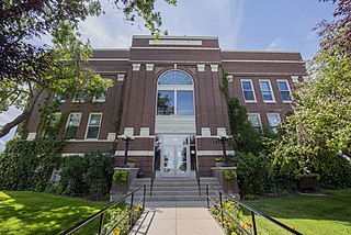
Teton County is a county in the U.S. state of Montana. As of the 2020 census, the population was 6,226. Its county seat is Choteau. The county was founded in 1893.

<span class="mw-page-title-main">Richland County, Montana</span> County in Montana, United States

Richland County is a county in the U.S. state of Montana. As of the 2020 census, the population was 11,491. Its county seat is Sidney.

<span class="mw-page-title-main">Pondera County, Montana</span> County in Montana, United States

Pondera County is a county in the U.S. state of Montana. As of the 2020 census, the population was 5,898. Its county seat is Conrad.

<span class="mw-page-title-main">Phillips County, Montana</span> County in Montana, United States

Phillips County is a county in the U.S. state of Montana. As of the 2020 census, the population was 4,217. Its county seat is Malta. Before February 5, 1915, Phillips County was part of Blaine County, and before 1912 both were part of Chouteau County. It was named for rancher and state senator Benjamin D. Phillips.

<span class="mw-page-title-main">Mineral County, Montana</span> County in Montana, United States

Mineral County is a county located in the U.S. state of Montana. As of the 2020 census, the population was 4,535. Its county seat is Superior.

<span class="mw-page-title-main">Madison County, Montana</span> County in Montana, United States

Madison County is a county in the U.S. state of Montana. As of the 2020 census, the population was 8,623. Its county seat is Virginia City. The county was founded in 1865; at the time it was part of the Montana Territory.

<span class="mw-page-title-main">Judith Basin County, Montana</span> County in Montana, United States

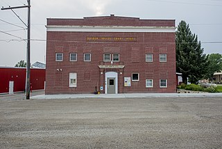
Judith Basin County is a county in the U.S. state of Montana. As of the 2020 census, the population was 2,023. Its county seat is the town of Stanford.

<span class="mw-page-title-main">Jefferson County, Montana</span> County in Montana, United States

Jefferson County is a county in Montana, United States. As of the 2020 census, the population was 12,085. Its county seat is Boulder. The county was created in 1865 and named for President Thomas Jefferson.

<span class="mw-page-title-main">Golden Valley County, Montana</span> County in Montana, United States

Golden Valley County is a county located in the U.S. state of Montana. As of the 2020 census, the population was 823, making it the third-least populous county in Montana. Its county seat is Ryegate.

<span class="mw-page-title-main">Fergus County, Montana</span> County in Montana, United States

Fergus County is a county in the U.S. state of Montana. As of the 2020 census, the population was 11,446. Its county seat is Lewistown. The county was founded in 1885 and named for James Fergus, a Montana politician who was instrumental in creating the county.

<span class="mw-page-title-main">Fallon County, Montana</span> County in Montana, United States

Fallon County is a county located in the U.S. state of Montana. As of the 2020 census, the population was 3,049. Its county seat is Baker. The county was created in 1913 from a portion of Custer County. It is named for Benjamin O'Fallon, a nephew of Captain William Clark and an Indian agent for the upper Missouri region from 1823 to 1827.

<span class="mw-page-title-main">Daniels County, Montana</span> County in Montana, United States

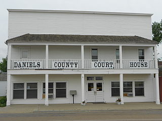
Daniels County is a county located in the U.S. state of Montana. As of the 2020 census, the population was 1,661. Its county seat is Scobey. It is on Montana's north border, and thus abuts the Canada–US border with Saskatchewan.

<span class="mw-page-title-main">Chouteau County, Montana</span> County in Montana, United States

Chouteau County is a county located in the North-Central region of the U.S. state of Montana. As of the 2020 census, the population was 5,895. Its county seat is Fort Benton. The county was established in 1865 as one of the original nine counties of Montana, and named in 1882 after Pierre Chouteau Jr., a fur trader who established a trading post that became Fort Benton, which was once an important port on the Missouri River.

<span class="mw-page-title-main">Carter County, Montana</span> County in Montana, United States

Carter County is a county located in the U.S. state of Montana. As of the 2020 census, the population was 1,415, making it the seventh-least populous county in Montana. The county seat is Ekalaka.

<span class="mw-page-title-main">Blaine County, Montana</span> County in Montana, United States

Blaine County is a county in the U.S. state of Montana. As of the 2020 census, the population was 7,044. Its county seat is Chinook. The county was named for James G. Blaine, former United States Secretary of State. It is on the north line of the state, and thus shares the southern border of Canada opposite Saskatchewan.

<span class="mw-page-title-main">Highwood, Montana</span> Census-designated place in Montana, United States

Highwood is an unincorporated community and census-designated place (CDP) in Chouteau County, Montana, United States. The population was 176 at the 2010 census.

<span class="mw-page-title-main">Loma, Montana</span> Census-designated place in Montana, United States

Loma is a census-designated place (CDP) in Chouteau County, Montana, United States. The population was 85 at the 2010 census.

<span class="mw-page-title-main">Chester, Montana</span> Town in Montana, United States

Chester is a town in and the county seat of Liberty County, Montana, United States. The population was 847 at the time of both the 2010 and 2020 U.S. Census.

References

  1. 1 2 "Montana County Formation Table". genealogytrails.com. Retrieved April 3, 2018.
  2. 1 2 "State & County QuickFacts". United States Census Bureau. Retrieved May 9, 2023.
  3. "Find a County". National Association of Counties. Archived from the original on May 31, 2011. Retrieved June 7, 2011.
  4. "History". Liberty County. Retrieved November 30, 2014.
  5. "2010 Census Gazetteer Files". United States Census Bureau. August 22, 2012. Archived from the original on December 5, 2014. Retrieved November 28, 2014.
  6. "Annual Estimates of the Resident Population for Counties: April 1, 2020 to July 1, 2022". United States Census Bureau. Retrieved May 9, 2023.
  7. "U.S. Decennial Census". United States Census Bureau. Retrieved November 28, 2014.
  8. "Historical Census Browser". University of Virginia Library. Retrieved November 28, 2014.
  9. "Population of Counties by Decennial Census: 1900 to 1990". United States Census Bureau. Retrieved November 28, 2014.
  10. "Census 2000 PHC-T-4. Ranking Tables for Counties: 1990 and 2000" (PDF). United States Census Bureau. Archived (PDF) from the original on March 27, 2010. Retrieved November 28, 2014.
  11. Facing Child Poverty in Rural America Archived February 8, 2012, at the Wayback Machine by William P. O'Hare and Kenneth M. Johnson, Population Reference Bureau, January 2004
  12. Leip, David. "Atlas of US Presidential Elections". uselectionatlas.org. Retrieved April 3, 2018.
  13. Hill MT Google Maps (accessed January 2, 2019)
  14. Lothair MT Google Maps (accessed January 2, 2019)
  15. Tiber MT Google Maps (accessed January 2, 2019)

48°33′N111°02′W / 48.55°N 111.03°W / 48.55; -111.03