Rosebud County, Montana

Last updated

Rosebud County
Rosebud county courthouse.jpg
County courthouse in Forsyth
Map of Montana highlighting Rosebud County.svg
Location within the U.S. state of Montana
Montana in United States.svg
Montana's location within the U.S.
Coordinates: 46°14′N106°43′W / 46.23°N 106.72°W / 46.23; -106.72
CountryFlag of the United States.svg United States
StateFlag of Montana.svg  Montana
FoundedFebruary 11, 1901
Named for Rosebud River
Seat Forsyth
Largest city Colstrip
Area
  Total5,027 sq mi (13,020 km2)
  Land5,010 sq mi (13,000 km2)
  Water17 sq mi (40 km2)  0.3%
Population
 (2020)
  Total8,329
  Estimate 
(2022)
8,088 Decrease2.svg
  Density1.7/sq mi (0.64/km2)
Time zone UTC−7 (Mountain)
  Summer (DST) UTC−6 (MDT)
Congressional district 2nd
Website rosebudcountymt.gov
  • Montana county number 29

Rosebud County is a county in the state of Montana. It was established February 11, 1901, and has Montana vehicle license plate prefix 29. [1] As of the 2020 census, the population was 8,329. [2] Its county seat is Forsyth. [3]

Contents

Geography

According to the United States Census Bureau, the county has a total area of 5,027 square miles (13,020 km2), of which 5,010 square miles (13,000 km2) is land and 17 square miles (44 km2) (0.3%) is water. [4] It is the fourth-largest county in Montana by land area and fifth-largest by total area. Part of Custer National Forest is located in the county.

Climate

According to the Köppen Climate Classification system, most of Rosebud County has a cold semi-arid climate, abbreviated "BSk" on climate maps.

Climate data for Brandenberg, Montana, 19912020 normals, extremes 1956present
MonthJanFebMarAprMayJunJulAugSepOctNovDecYear
Record high °F (°C)70
(21)
72
(22)
86
(30)
91
(33)
101
(38)
111
(44)
112
(44)
111
(44)
105
(41)
98
(37)
81
(27)
70
(21)
112
(44)
Mean maximum °F (°C)56.4
(13.6)
58.6
(14.8)
72.7
(22.6)
82.1
(27.8)
87.9
(31.1)
96.4
(35.8)
103.0
(39.4)
102.1
(38.9)
97.5
(36.4)
84.3
(29.1)
68.9
(20.5)
56.4
(13.6)
104.7
(40.4)
Mean daily maximum °F (°C)35.2
(1.8)
38.8
(3.8)
50.2
(10.1)
60.0
(15.6)
69.5
(20.8)
79.3
(26.3)
89.8
(32.1)
89.1
(31.7)
77.2
(25.1)
61.0
(16.1)
46.5
(8.1)
36.0
(2.2)
61.1
(16.1)
Daily mean °F (°C)22.9
(−5.1)
26.3
(−3.2)
36.4
(2.4)
45.6
(7.6)
55.1
(12.8)
64.4
(18.0)
72.4
(22.4)
70.8
(21.6)
60.3
(15.7)
46.7
(8.2)
33.9
(1.1)
24.2
(−4.3)
46.6
(8.1)
Mean daily minimum °F (°C)10.7
(−11.8)
13.9
(−10.1)
22.6
(−5.2)
31.3
(−0.4)
40.7
(4.8)
49.4
(9.7)
55.1
(12.8)
52.6
(11.4)
43.5
(6.4)
32.4
(0.2)
21.2
(−6.0)
12.5
(−10.8)
32.2
(0.1)
Mean minimum °F (°C)−18.0
(−27.8)
−12.0
(−24.4)
−1.6
(−18.7)
14.9
(−9.5)
25.1
(−3.8)
37.2
(2.9)
44.6
(7.0)
39.8
(4.3)
29.0
(−1.7)
14.3
(−9.8)
−2.4
(−19.1)
−11.7
(−24.3)
−26.7
(−32.6)
Record low °F (°C)−42
(−41)
−40
(−40)
−41
(−41)
−2
(−19)
16
(−9)
28
(−2)
34
(1)
30
(−1)
19
(−7)
−12
(−24)
−32
(−36)
−44
(−42)
−44
(−42)
Average precipitation inches (mm)0.55
(14)
0.61
(15)
0.91
(23)
1.71
(43)
3.12
(79)
2.55
(65)
1.44
(37)
0.91
(23)
1.21
(31)
1.37
(35)
0.54
(14)
0.55
(14)
15.47
(393)
Average snowfall inches (cm)7.5
(19)
8.0
(20)
6.9
(18)
4.0
(10)
0.5
(1.3)
0.0
(0.0)
0.0
(0.0)
0.0
(0.0)
0.0
(0.0)
1.7
(4.3)
4.4
(11)
7.4
(19)
40.4
(102.6)
Average precipitation days (≥ 0.01 in)7.36.97.49.011.010.07.15.46.17.16.16.389.7
Average snowy days (≥ 0.1 in)6.25.83.81.70.30.00.00.00.01.43.65.628.4
Source 1: NOAA [5]
Source 2: National Weather Service [6]

Demographics

Historical population
CensusPop.Note
1910 7,985
1920 8,0020.2%
1930 7,347−8.2%
1940 6,477−11.8%
1950 6,5701.4%
1960 6,187−5.8%
1970 6,032−2.5%
1980 9,89964.1%
1990 10,5056.1%
2000 9,383−10.7%
2010 9,233−1.6%
2020 8,329−9.8%
2022 (est.)8,088 [7] −2.9%
U.S. Decennial Census [8] [9] [10] [11]
2010–2020 [2]

2000 census

As of the 2020 census, there were 8,329 people living in the county.[ citation needed ]

2010 census

As of the 2010 census, there were 9,233 people, 3,395 households, and 2,318 families residing in the county. The population density was 1.8 inhabitants per square mile (0.69/km2). There were 4,057 housing units at an average density of 0.8 per square mile (0.31/km2). The racial makeup of the county was 61.3% white, 34.7% American Indian, 0.5% Asian, 0.3% black or African American, 0.5% from other races, and 2.8% from two or more races. Those of Hispanic or Latino origin made up 3.4% of the population. In terms of ancestry, 25.0% were American, 19.0% were German, 6.9% were English, and 6.6% were Irish.

Of the 3,395 households, 36.4% had children under the age of 18 living with them, 51.3% were married couples living together, 10.6% had a female householder with no husband present, 31.7% were non-families, and 27.6% of all households were made up of individuals. The average household size was 2.70 and the average family size was 3.32. The median age was 36.5 years.

The median income for a household in the county was $44,776 and the median income for a family was $56,282. Males had a median income of $52,500 versus $28,306 for females. The per capita income for the county was $19,844. About 13.6% of families and 18.5% of the population were below the poverty line, including 24.7% of those under age 18 and 21.3% of those age 65 or over.

Politics

Rosebud County voters have selected the Republican Party candidate in 60% of national elections since 1980 (as of 2020).

United States presidential election results for Rosebud County, Montana [12] [13]
Year Republican Democratic Third party
No.%No.%No.%
2020 2,48665.89%1,19931.78%882.33%
2016 2,25365.25%98728.58%2136.17%
2012 2,00456.88%1,42240.36%972.75%
2008 1,76846.40%1,91950.37%1233.23%
2004 1,98255.29%1,52042.40%832.32%
2000 1,82653.35%1,39440.72%2035.93%
1996 1,41338.37%1,68145.64%58915.99%
1992 1,13028.84%1,66942.60%1,11928.56%
1988 1,82248.05%1,86949.29%1012.66%
1984 2,41354.82%1,92043.62%691.57%
1980 1,87554.46%1,16733.89%40111.65%
1976 1,53851.16%1,41347.01%551.83%
1972 1,48663.23%77733.06%873.70%
1968 1,19056.42%71133.71%2089.86%
1964 1,10547.61%1,21252.22%40.17%
1960 1,38657.77%1,00241.77%110.46%
1956 1,51663.01%89036.99%00.00%
1952 1,73467.92%80531.53%140.55%
1948 1,10650.71%1,03147.27%442.02%
1944 1,15450.15%1,11448.41%331.43%
1940 1,25246.77%1,39952.26%260.97%
1936 86632.43%1,62460.82%1806.74%
1932 1,02736.63%1,64658.70%1314.67%
1928 1,51959.38%1,02540.07%140.55%
1924 1,11549.12%25911.41%89639.47%
1920 2,23968.22%87326.60%1705.18%
1916 1,33743.95%1,60852.86%973.19%
1912 39233.91%31327.08%45139.01%
1908 51566.03%23530.13%303.85%
1904 46075.66%13422.04%142.30%

Communities

Cities

Census-designated places

Unincorporated communities

Former communities

Notable people

See also

Footnotes

  1. "Montana History Wiki: Montana Counties". Archived from the original on November 19, 2015. Retrieved November 19, 2015.
  2. 1 2 "State & County QuickFacts". United States Census Bureau. Retrieved May 7, 2023.
  3. "Find a County". National Association of Counties. Retrieved June 7, 2011.
  4. "2010 Census Gazetteer Files". U.S. Census Bureau. August 22, 2012. Archived from the original on December 5, 2014. Retrieved November 29, 2014.
  5. "U.S. Climate Normals Quick Access". National Oceanic and Atmospheric Administration. Retrieved August 5, 2022.
  6. "NOAA Online Weather Data". National Weather Service. Retrieved August 5, 2022.
  7. "Annual Estimates of the Resident Population for Counties: April 1, 2020 to July 1, 2022". United States Census Bureau. Retrieved May 7, 2023.
  8. "U.S. Decennial Census". United States Census Bureau. Retrieved November 29, 2014.
  9. "Historical Census Browser". University of Virginia Library. Retrieved November 29, 2014.
  10. "Population of Counties by Decennial Census: 1900 to 1990". United States Census Bureau. Retrieved November 29, 2014.
  11. "Census 2000 PHC-T-4. Ranking Tables for Counties: 1990 and 2000" (PDF). U.S. Census Bureau. Archived (PDF) from the original on March 27, 2010. Retrieved November 29, 2014.
  12. Leip, David. "Atlas of US Presidential Elections". uselectionatlas.org. Retrieved April 3, 2018.
  13. The leading "other" candidate, Progressive Theodore Roosevelt, received 368 votes, while Socialist candidate Eugene Debs received 80 votes, and Write-in candidate Eugene Chafin received 3 votes.
  14. "Rosebud County news. [volume] (Forsyth, Mont.) 1901-1906, October 03, 1901, Image 5". October 3, 1901.

46°14′N106°43′W / 46.23°N 106.72°W / 46.23; -106.72

Related Research Articles

<span class="mw-page-title-main">Treasure County, Montana</span> County in Montana, United States

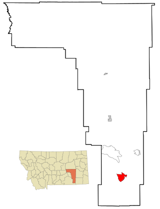
Treasure County is a county in the U.S. state of Montana. As of the 2020 census, the population was 762, making it the second-least populous county in Montana. Its county seat is Hysham. The county was founded in 1919.

<span class="mw-page-title-main">Sweet Grass County, Montana</span> County in Montana, United States

Sweet Grass County is a county located in the U.S. state of Montana. As of the 2020 census, the population was 3,678. Its county seat is Big Timber. The county was founded in 1895.

<span class="mw-page-title-main">Sheridan County, Montana</span> County in Montana, United States

Sheridan County is a county in the U.S. state of Montana. As of the 2020 census, the population was 3,539. Its county seat is Plentywood. Its northern boundary is the Canada–United States border south of Saskatchewan.

<span class="mw-page-title-main">Roosevelt County, Montana</span> County in Montana, United States

Roosevelt County is a county in the U.S. state of Montana. As of the 2020 census, the population was 10,794. Its county seat is Wolf Point. Roosevelt County was created by the Montana Legislature in 1919 from a portion of Sheridan County. The name honors former president Theodore Roosevelt, who had died earlier that year.

<span class="mw-page-title-main">Powell County, Montana</span> County in Montana, United States

Powell County is a county in the U.S. state of Montana. As of the 2020 census, the population was 6,946. Its county seat is Deer Lodge.

<span class="mw-page-title-main">Powder River County, Montana</span> County in Montana, United States

Powder River County is a county in the U.S. state of Montana. As of the 2020 census, the population was 1,694. Its county seat is Broadus.

<span class="mw-page-title-main">Pondera County, Montana</span> County in Montana, United States

Pondera County is a county in the U.S. state of Montana. As of the 2020 census, the population was 5,898. Its county seat is Conrad.

<span class="mw-page-title-main">Musselshell County, Montana</span> County in Montana, United States

Musselshell County is a county in south-central Montana. As of the 2020 census, the population was 4,730. Its county seat is Roundup.

<span class="mw-page-title-main">Garfield County, Montana</span> County in Montana, United States

Garfield County is a county located in the U.S. state of Montana. As of the 2020 census, the population was 1,173. Its county seat is Jordan.

<span class="mw-page-title-main">Custer County, Montana</span> County in Montana, United States

Custer County is a county located in the U.S. state of Montana. As of the 2020 census, the population was 11,867. Its county seat is Miles City. The county was established on June 2, 1865, as one of the nine original counties of the Territory of Montana named Big Horn County, and was renamed on February 16, 1877, in honor of Lieutenant Colonel George Armstrong Custer.

<span class="mw-page-title-main">Big Horn County, Montana</span> County in Montana, United States

Big Horn County is a county located in the U.S. state of Montana. As of the 2020 census, the population was 13,124. The county seat is Hardin. The county, like the river and the mountain range, is named after the bighorn sheep in the Rocky Mountains. The county was founded in 1913. It is located on the south line of the state.

<span class="mw-page-title-main">Busby, Montana</span> Census-designated place in Big Horn County, Montana, United States

Busby is a census-designated place (CDP) in Big Horn County, Montana, United States. It is on the Northern Cheyenne reservation. The population was 745 at the 2010 census.

<span class="mw-page-title-main">Jordan, Montana</span> Town in Montana, United States

Jordan is a town in and the county seat of Garfield County, Montana, United States. The population was 356 at the 2020 census. It is Garfield County's only incorporated community.

<span class="mw-page-title-main">Ravalli, Montana</span> Place in Montana, United States

Ravalli is an unincorporated community in Lake County, Montana, United States. The population was 76 at the 2010 census, down from 119 in 2000. For statistical purposes, the United States Census Bureau has defined Ravalli as a census-designated place (CDP). In the early 1900s, the Pablo-Allard herd in Ravalli was said to be the largest collection of the bison remaining in the U.S. and played a critical role in the conservation of bison.

<span class="mw-page-title-main">Ashland, Montana</span> CDP in Montana, United States

Ashland is a census-designated place (CDP) in Rosebud County, Montana, United States. The population was 464 at the 2000 census. Ashland is immediately east of the boundary of the Northern Cheyenne Indian Reservation and also along the Tongue River. It is the location of the St. Labre Indian Catholic High School, established in 1884 as a boarding school by a Catholic mission to the Cheyenne.

<span class="mw-page-title-main">Birney, Montana</span> Census-designated place in Montana, United States

Birney is a census-designated place (CDP) in Rosebud County, Montana, United States. The population was 108 at the 2000 census.

<span class="mw-page-title-main">Colstrip, Montana</span> City in Montana, United States

Colstrip is a city in Rosebud County, Montana, United States. The population was 2,096 at the 2020 census.

<span class="mw-page-title-main">Forsyth, Montana</span> City in Montana, United States

Forsyth is a city in and the county seat of Rosebud County, Montana, United States. The population was 1,647 at the 2020 census. Forsyth was established in 1876 as the first settlement on the Yellowstone River, and in 1882 residents named the town after General James William Forsyth who commanded Fort Maginnis, Montana during the Indian Wars and the 7th Cavalry at the Wounded Knee Massacre. The town has long been a transportation nexus, starting with steamboats on the river and progressing to the Northern Pacific Railway and Interstate 94.

<span class="mw-page-title-main">Lame Deer, Montana</span> CDP in Montana, United States

Lame Deer is a census-designated place (CDP) in Rosebud County, Montana, United States. The community is named after Miniconjou Lakota chief Lame Deer, who was killed by the U.S. Army in 1877 under a flag of truce south of the town. It was the site of a trading post from the late 1870s.

<span class="mw-page-title-main">Cardwell, Montana</span> Census-designated place in Montana, United States

Cardwell is a census-designated place (CDP) in Jefferson County, Montana, United States. The population was 62 at the 2020 census. It is part of the Helena Micropolitan Statistical Area.