Carter County, Montana

Last updated

Carter County
Ekalaka MT Carter County Courthouse.jpg
Carter County Courthouse in Ekalaka
Map of Montana highlighting Carter County.svg
Location within the U.S. state of Montana
Montana in United States.svg
Montana's location within the U.S.
Coordinates: 45°30′N104°32′W / 45.5°N 104.54°W / 45.5; -104.54
CountryFlag of the United States.svg United States
StateFlag of Montana.svg  Montana
Founded1917
Named for Thomas H. Carter
Seat Ekalaka
Largest townEkalaka
Area
  Total3,348 sq mi (8,670 km2)
  Land3,341 sq mi (8,650 km2)
  Water7.5 sq mi (19 km2)  0.2%
Population
 (2020)
  Total1,415
  Estimate 
(2022)
1,382 Decrease2.svg
  Density0.42/sq mi (0.16/km2)
Time zone UTC−7 (Mountain)
  Summer (DST) UTC−6 (MDT)
Congressional district 2nd
Website www.cartercountymt.info
  • Montana county number 42
Aragonite specimen from Carter County Aragonite-4jb19-lc113b.jpg
Aragonite specimen from Carter County

Carter County is a county located in the U.S. state of Montana. As of the 2020 census, the population was 1,415, [1] making it the seventh-least populous county in Montana. The county seat is Ekalaka. [2]

Contents

History

Carter County was named for Thomas Henry Carter, the state's first congressman (representative in Congress from the Montana Territory, followed by first representative from the state of Montana to the US House of Representatives). Prior to settlement the land of Carter County was occupied by the Sioux tribe. [3]

Geography

According to the United States Census Bureau, the county has a total area of 3,348 square miles (8,670 km2), of which 3,341 square miles (8,650 km2) is land and 7.5 square miles (19 km2) (0.2%) is water. [4]

Medicine Rocks State Park is located 14 miles north of Ekalaka. Weathering has given the rocks an unusual texture. The site was used by Indian hunting parties. [5]

Adjacent counties

National protected area

Demographics

Historical population
CensusPop.Note
1920 3,972
1930 4,1364.1%
1940 3,280−20.7%
1950 2,798−14.7%
1960 2,493−10.9%
1970 1,956−21.5%
1980 1,799−8.0%
1990 1,503−16.5%
2000 1,360−9.5%
2010 1,160−14.7%
2020 1,41522.0%
2022 (est.)1,382 [6] −2.3%
U.S. Decennial Census [7]
1790–1960, [8] 1900–1990, [9]
1990–2000, [10] 2010–2020 [1]

2020 census

As of the 2020 census, there were 1,415 people and 628 households in Carter County. [11] Of the population, 96.7% were White, 0.2% Black or African American, 1.0% Native American, 0.1% Asian, and 1.9% two or more races. 1.1% were Hispanic. 1.0% had a different primary language to English. The county was 50.1% female, 49.9% male. [11]

The median household income was $48,000, $6,970 below the median of Montana. 61.7% of the population aged over 16 were in the civilian labor force. 14.7% of the population were classed as living in poverty. 2.4% of the population had a disability. 92.5% of the population graduated high school, with 20.2% obtaining a bachelor's degree or higher. 86.5% of households had a computer, with 77.9% having broadband access. [11]

2010 census

As of the 2010 census, there were 1,160 people, 532 households, and 354 families living in the county. The population density was 0.3 inhabitants per square mile (0.12/km2). There were 810 housing units at an average density of 0.2 per square mile (0.077/km2). The racial makeup of the county was 97.8% white, 0.9% American Indian, 0.1% black or African American, 0.1% Asian, 0.3% from other races, and 0.8% from two or more races. Those of Hispanic or Latino origin made up 0.7% of the population. In terms of ancestry, 41.5% were German, 19.6% were English, 18.8% were Norwegian, 12.3% were Irish, and 4.3% were American.

Of the 532 households, 20.5% had children under the age of 18 living with them, 59.4% were married couples living together, 4.3% had a female householder with no husband present, 33.5% were non-families, and 30.3% of all households were made up of individuals. The average household size was 2.16 and the average family size was 2.65. The median age was 50.2 years.

The median income for a household in the county was $35,703 and the median income for a family was $47,955. Males had a median income of $26,736 versus $18,274 for females. The per capita income for the county was $20,681. About 8.5% of families and 14.0% of the population were below the poverty line, including 20.4% of those under age 18 and 10.8% of those age 65 or over.

Politics

Carter County has voted for the Republican candidate in every presidential election since 1952, with Harry S. Truman being the last Democrat to carry the county.

United States presidential election results for Carter County, Montana [12]
Year Republican Democratic Third party
No.%No.%No.%
2020 77589.70%748.56%151.74%
2016 67886.26%708.91%384.83%
2012 67885.18%9612.06%222.76%
2008 57379.36%11115.37%385.26%
2004 62387.87%7610.72%101.41%
2000 57388.84%538.22%192.95%
1996 52268.24%15019.61%9312.16%
1992 49756.86%15417.62%22325.51%
1988 68672.82%24225.69%141.49%
1984 82380.06%19418.87%111.07%
1980 76672.40%23722.40%555.20%
1976 55857.41%34435.39%707.20%
1972 72673.86%21822.18%393.97%
1968 62462.21%26926.82%11010.97%
1964 57655.98%45344.02%00.00%
1960 68864.00%38335.63%40.37%
1956 69861.55%43638.45%00.00%
1952 92172.12%35127.49%50.39%
1948 50146.22%56852.40%151.38%
1944 50745.35%61054.56%10.09%
1940 55643.03%73456.81%20.15%
1936 46432.81%92965.70%211.49%
1932 56537.39%91560.56%312.05%
1928 76364.01%42035.23%90.76%
1924 66954.17%28322.91%28322.91%
1920 78266.84%34229.23%463.93%

Communities

Town

Census-designated place

Unincorporated communities

Former communities

See also

Related Research Articles

<span class="mw-page-title-main">Valley County, Montana</span> County in Montana, United States

Valley County is a county in the U.S. state of Montana. Valley County was created in 1893 with area partitioned from Dawson County. As of the 2020 census, the population was 7,578. Its county seat is Glasgow. It is located on the Canada–United States border with Saskatchewan.

<span class="mw-page-title-main">Teton County, Montana</span> County in Montana, United States

Teton County is a county in the U.S. state of Montana. As of the 2020 census, the population was 6,226. Its county seat is Choteau. The county was founded in 1893.

<span class="mw-page-title-main">Roosevelt County, Montana</span> County in Montana, United States

Roosevelt County is a county in the U.S. state of Montana. As of the 2020 census, the population was 10,794. Its county seat is Wolf Point. Roosevelt County was created by the Montana Legislature in 1919 from a portion of Sheridan County. The name honors former president Theodore Roosevelt, who had died earlier that year.

<span class="mw-page-title-main">Richland County, Montana</span> County in Montana, United States

Richland County is a county in the U.S. state of Montana. As of the 2020 census, the population was 11,491. Its county seat is Sidney.

<span class="mw-page-title-main">Powder River County, Montana</span> County in Montana, United States

Powder River County is a county in the U.S. state of Montana. As of the 2020 census, the population was 1,694. Its county seat is Broadus.

<span class="mw-page-title-main">Pondera County, Montana</span> County in Montana, United States

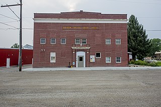
Pondera County is a county in the U.S. state of Montana. As of the 2020 census, the population was 5,898. Its county seat is Conrad.

<span class="mw-page-title-main">Phillips County, Montana</span> County in Montana, United States

Phillips County is a county in the U.S. state of Montana. As of the 2020 census, the population was 4,217. Its county seat is Malta. Before February 5, 1915, Phillips County was part of Blaine County, and before 1912 both were part of Chouteau County. It was named for rancher and state senator Benjamin D. Phillips.

<span class="mw-page-title-main">Mineral County, Montana</span> County in Montana, United States

Mineral County is a county located in the U.S. state of Montana. As of the 2020 census, the population was 4,535. Its county seat is Superior.

<span class="mw-page-title-main">Meagher County, Montana</span> County in Montana, United States

Meagher County is a county located in the U.S. state of Montana. As of the 2020 census, the population was 1,927. Its county seat is White Sulphur Springs.

<span class="mw-page-title-main">Madison County, Montana</span> County in Montana, United States

Madison County is a county in the U.S. state of Montana. As of the 2020 census, the population was 8,623. Its county seat is Virginia City. The county was founded in 1865; at the time it was part of the Montana Territory.

<span class="mw-page-title-main">Judith Basin County, Montana</span> County in Montana, United States

Judith Basin County is a county in the U.S. state of Montana. As of the 2020 census, the population was 2,023. Its county seat is the town of Stanford.

<span class="mw-page-title-main">Jefferson County, Montana</span> County in Montana, United States

Jefferson County is a county in Montana, United States. As of the 2020 census, the population was 12,085. Its county seat is Boulder. The county was created in 1865 and named for President Thomas Jefferson.

<span class="mw-page-title-main">Granite County, Montana</span> County in Montana, United States

Granite County is a county located in the U.S. state of Montana. As of the 2020 census, the population was 3,309. Its county seat is Philipsburg. The county was founded in 1893, and was named for a mountain which contains the Granite Mountain silver mine.

<span class="mw-page-title-main">Golden Valley County, Montana</span> County in Montana, United States

Golden Valley County is a county located in the U.S. state of Montana. As of the 2020 census, the population was 823, making it the third-least populous county in Montana. Its county seat is Ryegate.

<span class="mw-page-title-main">Garfield County, Montana</span> County in Montana, United States

Garfield County is a county located in the U.S. state of Montana. As of the 2020 census, the population was 1,173. Its county seat is Jordan.

<span class="mw-page-title-main">Fallon County, Montana</span> County in Montana, United States

Fallon County is a county located in the U.S. state of Montana. As of the 2020 census, the population was 3,049. Its county seat is Baker. The county was created in 1913 from a portion of Custer County. It is named for Benjamin O'Fallon, a nephew of Captain William Clark and an Indian agent for the upper Missouri region from 1823 to 1827.

<span class="mw-page-title-main">Daniels County, Montana</span> County in Montana, United States

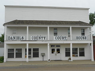
Daniels County is a county located in the U.S. state of Montana. As of the 2020 census, the population was 1,661. Its county seat is Scobey. It is on Montana's north border, and thus abuts the Canada–US border with Saskatchewan.

<span class="mw-page-title-main">Chouteau County, Montana</span> County in Montana, United States

Chouteau County is a county located in the North-Central region of the U.S. state of Montana. As of the 2020 census, the population was 5,895. Its county seat is Fort Benton. The county was established in 1865 as one of the original nine counties of Montana, and named in 1882 after Pierre Chouteau Jr., a fur trader who established a trading post that became Fort Benton, which was once an important port on the Missouri River.

<span class="mw-page-title-main">Broadwater County, Montana</span> County in Montana, United States

Broadwater County is a county in the U.S. state of Montana. As of the 2020 census, the population was 6,774. Its county seat is Townsend. The county was named for Charles Arthur Broadwater, a noted Montana railroad, real estate, and banking magnate.

<span class="mw-page-title-main">Ekalaka, Montana</span> Town in Montana, United States

Ekalaka is a town in and the county seat of Carter County, Montana, United States. The population was 399 at the 2020 census.

References

  1. 1 2 "State & County QuickFacts". United States Census Bureau. Retrieved May 9, 2023.
  2. "Find a County". National Association of Counties. Archived from the original on May 31, 2011. Retrieved June 7, 2011.
  3. Merrill, Andrea; Judy Jacobson (1997). Montana almanac. Helena MT: Falcon Publishing. ISBN   1-56044-493-2.
  4. "2010 Census Gazetteer Files". United States Census Bureau. August 22, 2012. Archived from the original on December 5, 2014. Retrieved November 27, 2014.
  5. Visit MT. "Medicine Rocks State Park". Archived from the original on July 17, 2011. Retrieved July 20, 2011.
  6. "Annual Estimates of the Resident Population for Counties: April 1, 2020 to July 1, 2022". United States Census Bureau. Retrieved May 9, 2023.
  7. "U.S. Decennial Census". United States Census Bureau. Retrieved November 27, 2014.
  8. "Historical Census Browser". University of Virginia Library. Retrieved November 27, 2014.
  9. "Population of Counties by Decennial Census: 1900 to 1990". United States Census Bureau. Retrieved November 27, 2014.
  10. "Census 2000 PHC-T-4. Ranking Tables for Counties: 1990 and 2000" (PDF). United States Census Bureau. Archived (PDF) from the original on March 27, 2010. Retrieved November 27, 2014.
  11. 1 2 3 "Carter County, Montana; Montana". census.gov. Retrieved February 27, 2022.
  12. Leip, David. "Atlas of US Presidential Elections". uselectionatlas.org. Retrieved April 2, 2018.
  13. Albion, Carter County MT Google Maps (accessed January 1, 2019)
  14. Belltower, Carter County MT Google Maps (accessed January 1, 2019)
  15. Boyes, Carter County MT Google Maps (accessed January 1, 2019)
  16. Ridge, Carter County MT Google Maps (accessed January 1, 2019)

45°30′N104°32′W / 45.50°N 104.54°W / 45.50; -104.54