Granite County, Montana

Last updated

Granite County
Granite County Courthouse July 2020.jpg
Granite County Courthouse
Map of Montana highlighting Granite County.svg
Location within the U.S. state of Montana
Montana in United States.svg
Montana's location within the U.S.
Coordinates: 46°25′N113°27′W / 46.42°N 113.45°W / 46.42; -113.45
CountryFlag of the United States.svg United States
StateFlag of Montana.svg  Montana
FoundedMarch 2, 1893 [1]
Seat Philipsburg
Largest townPhilipsburg
Area
  Total1,733 sq mi (4,490 km2)
  Land1,727 sq mi (4,470 km2)
  Water5.6 sq mi (15 km2)  0.3%
Population
 (2020)
  Total3,309
  Estimate 
(2022)
3,502 Increase2.svg
  Density1.9/sq mi (0.74/km2)
Time zone UTC−7 (Mountain)
  Summer (DST) UTC−6 (MDT)
Congressional district 1st
Website www.co.granite.mt.us
  • Montana county number 46

Granite County is a county located in the U.S. state of Montana. As of the 2020 census, the population was 3,309. [2] Its county seat is Philipsburg. [3] The county was founded in 1893, and was named for a mountain which contains the Granite Mountain silver mine. [4]

Contents

Geography

According to the United States Census Bureau, the county has a total area of 1,733 square miles (4,490 km2), of which 1,727 square miles (4,470 km2) is land and 5.6 square miles (15 km2) (0.3%) is water. [5]

Major highways

Adjacent counties

National protected areas

Politics

United States presidential election results for Granite County, Montana [6] [7]
Year Republican Democratic Third party
No.%No.%No.%
2020 1,41967.51%63830.35%452.14%
2016 1,19267.08%47226.56%1136.36%
2012 1,10764.93%53331.26%653.81%
2008 1,01358.96%60134.98%1046.05%
2004 1,14471.28%40425.17%573.55%
2000 1,18174.28%29518.55%1147.17%
1996 73352.10%42930.49%24517.41%
1992 55642.06%35827.08%40830.86%
1988 78959.50%51138.54%261.96%
1984 88066.57%41731.54%251.89%
1980 81159.15%43932.02%1218.83%
1976 74658.65%50940.02%171.34%
1972 80462.28%42232.69%655.03%
1968 62649.56%50239.75%13510.69%
1964 52744.40%65855.43%20.17%
1960 72254.57%59244.75%90.68%
1956 89662.70%53337.30%00.00%
1952 92365.88%47333.76%50.36%
1948 65951.97%56744.72%423.31%
1944 70254.50%57444.57%120.93%
1940 78445.85%91753.63%90.53%
1936 47527.55%1,22771.17%221.28%
1932 53637.25%85559.42%483.34%
1928 84962.15%50937.26%80.59%
1924 58243.47%35326.36%40430.17%
1920 94964.21%43929.70%906.09%
1916 57438.81%81254.90%936.29%
1912 19521.93%34638.92%34839.15%
1908 36940.46%48553.18%586.36%
1904 57649.40%52144.68%695.92%

Demographics

Historical population
CensusPop.Note
1900 4,328
1910 2,942−32.0%
1920 4,16741.6%
1930 3,013−27.7%
1940 3,40112.9%
1950 2,773−18.5%
1960 3,0148.7%
1970 2,737−9.2%
1980 2,700−1.4%
1990 2,548−5.6%
2000 2,83011.1%
2010 3,0798.8%
2020 3,3097.5%
2022 (est.)3,502 [8] 5.8%
U.S. Decennial Census [9]
1790–1960, [10] 1900–1990, [11]
1990–2000, [12] 2010–2020 [2]

2020 census

As of the 2020 census, there were 3,309 people living in the county.[ citation needed ]

2010 census

As of the 2010 census, there were 3,079 people, 1,417 households, and 911 families living in the county. The population density was 1.8 inhabitants per square mile (0.69/km2). There were 2,822 housing units at an average density of 1.6 per square mile (0.62/km2). The racial makeup of the county was 97.5% white, 0.4% American Indian, 0.1% black or African American, 0.1% Asian, 0.2% from other races, and 1.7% from two or more races. Those of Hispanic or Latino origin made up 1.4% of the population. In terms of ancestry, 26.2% were German, 20.2% were Irish, 18.8% were English, 13.5% were Norwegian, and 7.9% were American.

Of the 1,417 households, 19.6% had children under the age of 18 living with them, 55.3% were married couples living together, 5.7% had a female householder with no husband present, 35.7% were non-families, and 29.5% of all households were made up of individuals. The average household size was 2.14 and the average family size was 2.63. The median age was 52.1 years.

The median income for a household in the county was $36,052 and the median income for a family was $47,685. Males had a median income of $41,307 versus $23,958 for females. The per capita income for the county was $23,222. About 7.5% of families and 12.1% of the population were below the poverty line, including 5.4% of those under age 18 and 13.3% of those age 65 or over.

Communities

The Historic Granite County Jail in Philipsburg, Montana. Granite County Jail.jpg
The Historic Granite County Jail in Philipsburg, Montana.

Towns

Census-designated places

Unincorporated communities

Ghost Towns

See also

Related Research Articles

<span class="mw-page-title-main">Valley County, Montana</span> County in Montana, United States

Valley County is a county in the U.S. state of Montana. Valley County was created in 1893 with area partitioned from Dawson County. As of the 2020 census, the population was 7,578. Its county seat is Glasgow. It is located on the Canada–United States border with Saskatchewan.

<span class="mw-page-title-main">Teton County, Montana</span> County in Montana, United States

Teton County is a county in the U.S. state of Montana. As of the 2020 census, the population was 6,226. Its county seat is Choteau. The county was founded in 1893.

<span class="mw-page-title-main">Roosevelt County, Montana</span> County in Montana, United States

Roosevelt County is a county in the U.S. state of Montana. As of the 2020 census, the population was 10,794. Its county seat is Wolf Point. Roosevelt County was created by the Montana Legislature in 1919 from a portion of Sheridan County. The name honors former president Theodore Roosevelt, who had died earlier that year.

<span class="mw-page-title-main">Richland County, Montana</span> County in Montana, United States

Richland County is a county in the U.S. state of Montana. As of the 2020 census, the population was 11,491. Its county seat is Sidney.

<span class="mw-page-title-main">Ravalli County, Montana</span> County in Montana, United States

Ravalli County is a county in the southwestern part of the U.S. state of Montana. As of the 2020 census, the population was 44,174. Its county seat is Hamilton.

<span class="mw-page-title-main">Powell County, Montana</span> County in Montana, United States

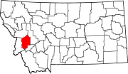
Powell County is a county in the U.S. state of Montana. As of the 2020 census, the population was 6,946. Its county seat is Deer Lodge.

<span class="mw-page-title-main">Powder River County, Montana</span> County in Montana, United States

Powder River County is a county in the U.S. state of Montana. As of the 2020 census, the population was 1,694. Its county seat is Broadus.

<span class="mw-page-title-main">Pondera County, Montana</span> County in Montana, United States

Pondera County is a county in the U.S. state of Montana. As of the 2020 census, the population was 5,898. Its county seat is Conrad.

<span class="mw-page-title-main">Park County, Montana</span> County in Montana, United States

Park County is a county in the U.S. state of Montana. At the 2020 census, the population was 17,191. Its county seat is Livingston. A small part of Yellowstone National Park is in the southern part of the county.

<span class="mw-page-title-main">Mineral County, Montana</span> County in Montana, United States

Mineral County is a county located in the U.S. state of Montana. As of the 2020 census, the population was 4,535. Its county seat is Superior.

<span class="mw-page-title-main">Meagher County, Montana</span> County in Montana, United States

Meagher County is a county located in the U.S. state of Montana. As of the 2020 census, the population was 1,927. Its county seat is White Sulphur Springs.

<span class="mw-page-title-main">Madison County, Montana</span> County in Montana, United States

Madison County is a county in the U.S. state of Montana. As of the 2020 census, the population was 8,623. Its county seat is Virginia City. The county was founded in 1865; at the time it was part of the Montana Territory.

<span class="mw-page-title-main">Lincoln County, Montana</span> County in Montana, United States

Lincoln County is a county located in the U.S. state of Montana. As of the 2020 census, the population was 19,677. Its county seat is Libby. The county was founded in 1909 and named for President Abraham Lincoln. The county lies on Montana's north border and thus shares the US-Canadian border with the Canadian province of British Columbia.

<span class="mw-page-title-main">Lewis and Clark County, Montana</span> County in Montana, United States

Lewis and Clark County is a county located in the U.S. state of Montana. As of the 2020 census, the population was 70,973. Its county seat is Helena, the state capital. The numerical designation for Lewis and Clark County is 5. The county was established on June 2, 1865, as one of the nine original counties of the Territory of Montana named Edgerton County in honor of Sidney Edgerton, first Governor of the Territory of Montana, and was renamed Lewis and Clark County on March 1, 1868, in honor of explorers Meriwether Lewis and William Clark.

<span class="mw-page-title-main">Jefferson County, Montana</span> County in Montana, United States

Jefferson County is a county in Montana, United States. As of the 2020 census, the population was 12,085. Its county seat is Boulder. The county was created in 1865 and named for President Thomas Jefferson.

<span class="mw-page-title-main">Fergus County, Montana</span> County in Montana, United States

Fergus County is a county in the U.S. state of Montana. As of the 2020 census, the population was 11,446. Its county seat is Lewistown. The county was founded in 1885 and named for James Fergus, a Montana politician who was instrumental in creating the county.

<span class="mw-page-title-main">Chouteau County, Montana</span> County in Montana, United States

Chouteau County is a county located in the North-Central region of the U.S. state of Montana. As of the 2020 census, the population was 5,895. Its county seat is Fort Benton. The county was established in 1865 as one of the original nine counties of Montana, and named in 1882 after Pierre Chouteau Jr., a fur trader who established a trading post that became Fort Benton, which was once an important port on the Missouri River.

<span class="mw-page-title-main">Broadwater County, Montana</span> County in Montana, United States

Broadwater County is a county in the U.S. state of Montana. As of the 2020 census, the population was 6,774. Its county seat is Townsend. The county was named for Charles Arthur Broadwater, a noted Montana railroad, real estate, and banking magnate.

<span class="mw-page-title-main">Big Horn County, Montana</span> County in Montana, United States

Big Horn County is a county located in the U.S. state of Montana. As of the 2020 census, the population was 13,124. The county seat is Hardin. The county, like the river and the mountain range, is named after the bighorn sheep in the Rocky Mountains. The county was founded in 1913. It is located on the south line of the state.

<span class="mw-page-title-main">Philipsburg, Montana</span> Town in Montana, United States

Philipsburg is a town in and the county seat of Granite County, Montana, United States. The population was 841 at the 2020 census. The town was named after the famous mining engineer Philip Deidesheimer, who designed and supervised the construction of the ore smelter around which the town originally formed. He platted the townsite in 1867.

References

  1. Montana County Formation Time Line
  2. 1 2 "State & County QuickFacts". United States Census Bureau. Retrieved May 8, 2023.
  3. "Find a County". National Association of Counties. Archived from the original on May 31, 2011. Retrieved June 7, 2011.
  4. Gannett, Henry (1905). The Origin of Certain Place Names in the United States. Govt. Print. Off. p.  141.
  5. "2010 Census Gazetteer Files". United States Census Bureau. August 22, 2012. Archived from the original on December 5, 2014. Retrieved November 28, 2014.
  6. Leip, David. "Atlas of US Presidential Elections". uselectionatlas.org. Retrieved April 3, 2018.
  7. The leading "other" candidate, Progressive Theodore Roosevelt, received 356 votes, while Socialist candidate Eugene Debs received 92 votes.
  8. "Annual Estimates of the Resident Population for Counties: April 1, 2020 to July 1, 2022". United States Census Bureau. Retrieved May 8, 2023.
  9. "U.S. Decennial Census". United States Census Bureau. Retrieved November 28, 2014.
  10. "Historical Census Browser". University of Virginia Library. Retrieved November 28, 2014.
  11. "Population of Counties by Decennial Census: 1900 to 1990". United States Census Bureau. Retrieved November 28, 2014.
  12. "Census 2000 PHC-T-4. Ranking Tables for Counties: 1990 and 2000" (PDF). United States Census Bureau. Archived (PDF) from the original on March 27, 2010. Retrieved November 28, 2014.
  13. Beartown, Granite County MT Google Maps (accessed January 2, 2019)
  14. New Chicago, Granite County MT Google Maps (accessed January 2, 2019)
  15. Quigley, Granite County MT Google Maps (accessed January 2, 2019)
  16. Princeton, Granite County MT Google Maps (accessed January 2, 2019)
  17. Sherryl, Granite County MT Google Maps (accessed January 2, 2019)
  18. Stone, Granite County MT Google Maps (accessed January 2, 2019)

Further reading

46°25′N113°27′W / 46.42°N 113.45°W / 46.42; -113.45