Musselshell County, Montana

Last updated

Musselshell County
Musselshell County Courthouse July 2020.jpg
The Musselshell County Courthouse in Roundup
Map of Montana highlighting Musselshell County.svg
Location within the U.S. state of Montana
Montana in United States.svg
Montana's location within the U.S.
Coordinates: 46°29′N108°24′W / 46.49°N 108.4°W / 46.49; -108.4
CountryFlag of the United States.svg United States
StateFlag of Montana.svg  Montana
FoundedFebruary 2, 1911 [1]
Seat Roundup
Largest cityRoundup
Area
[2]
  Total1,871 sq mi (4,850 km2)
  Land1,868 sq mi (4,840 km2)
  Water2.8 sq mi (7 km2)  0.1%
Population
 (2020)
  Total4,730
  Estimate 
(2022)
5,197 Increase2.svg
  Density2.5/sq mi (0.98/km2)
Time zone UTC−7 (Mountain)
  Summer (DST) UTC−6 (MDT)
Congressional district 2nd
Website musselshellcounty.org
  • Montana county number 23

Musselshell County is a county in south-central Montana. As of the 2020 census, the population was 4,730. [3] Its county seat is Roundup. [4]

Contents

History

Musselshell County was created in 1911 by Montana Governor Edwin L. Norris. The area was taken from Fergus, from Yellowstone, and Meagher counties. It was named for the Musselshell River which runs southwest–northeast through the county. That river had been thus named in 1805 by the Lewis and Clark Expedition, due to the abundance of freshwater mussels found along its banks. In 1915, a western portion of the county was partitioned off to form Golden Valley County, giving Musselshell County its present boundaries.

The county's northwestern area is rolling grasslands, which slope southeastward to the Musselshell River and the forested Bull Mountains in the southeast. The county has abundant natural resources of coal deposits, subterranean oil, and timbered slopes. [1]

Geography

According to the United States Census Bureau, the county has a total area of 1,863.91 square miles (4,827.5 km2), of which 1,861.16 square miles (4,820.4 km2) is land and 2.75 square miles (7.1 km2) (0.1%) is water. [5]

Major highways

Adjacent counties

National protected area

Politics

In the fourteen national elections after its organization, Musselshell County voters selected Republican presidential candidates 50% of the time, and Democratic candidates 50% of the time. However, since the 1968 election, the Republican candidate has been selected in every election.

United States presidential election results for Musselshell County, Montana [6] [7]
Year Republican Democratic Third party
No.%No.%No.%
2020 2,42384.10%41314.34%451.56%
2016 1,96780.58%33213.60%1425.82%
2012 1,83376.15%49220.44%823.41%
2008 1,58168.56%63627.58%893.86%
2004 1,66374.01%53823.94%462.05%
2000 1,58271.68%51223.20%1135.12%
1996 1,12154.00%65231.41%30314.60%
1992 87639.32%64829.08%70431.60%
1988 1,28058.08%89840.74%261.18%
1984 1,54165.32%78133.11%371.57%
1980 1,27958.03%78435.57%1416.40%
1976 1,11754.09%92244.65%261.26%
1972 1,20261.11%68935.03%763.86%
1968 95351.15%79542.67%1156.17%
1964 82340.90%1,18959.10%00.00%
1960 1,10750.09%1,10049.77%30.14%
1956 1,16551.10%1,11548.90%00.00%
1952 1,25350.08%1,24049.56%90.36%
1948 1,01040.46%1,18847.60%29811.94%
1944 1,00442.27%1,34256.51%291.22%
1940 1,08636.79%1,80761.21%592.00%
1936 77125.58%2,09269.41%1515.01%
1932 1,02135.95%1,58455.77%2358.27%
1928 1,60850.55%1,44445.39%1294.06%
1924 1,48845.55%2477.56%1,53246.89%
1920 1,91059.22%95129.49%36411.29%
1916 1,73842.92%2,03650.28%2756.79%
1912 48330.80%47029.97%61539.22%

Demographics

Historical population
CensusPop.Note
1920 12,030
1930 7,242−39.8%
1940 5,717−21.1%
1950 5,408−5.4%
1960 4,888−9.6%
1970 3,734−23.6%
1980 4,42818.6%
1990 4,106−7.3%
2000 4,4979.5%
2010 4,5380.9%
2020 4,7304.2%
2022 (est.)5,197 [8] 9.9%
U.S. Decennial Census [9]
1790–1960, [10] 1900–1990, [11]
1990–2000, [12] 2010–2020 [3]

2020 census

As of the 2020 census, there were 4,730 people living in the county.[ citation needed ]

2010 census

As of the 2010 census, there were 4,538 people, 2,046 households, and 1,276 families in the county. The population density was 2.4 inhabitants per square mile (0.93/km2). There were 2,654 housing units at an average density of 1.4 units per square mile (0.54 units/km2). The racial makeup of the county was 96.1% white, 1.3% American Indian, 0.2% black or African American, 0.2% Asian, 0.2% from other races, and 1.9% from two or more races. Those of Hispanic or Latino origin made up 2.6% of the population. In terms of ancestry, 28.1% were German, 16.5% were English, 16.1% were Irish, 7.6% were Norwegian, and 7.0% were American.

Of the 2,046 households, 23.2% had children under the age of 18 living with them, 52.4% were married couples living together, 6.5% had a female householder with no husband present, 37.6% were non-families, and 33.5% of all households were made up of individuals. The average household size was 2.19 and the average family size was 2.78. The median age was 49.1 years.

The median income for a household in the county was $37,033 and the median income for a family was $47,860. Males had a median income of $33,182 versus $25,750 for females. The per capita income for the county was $20,875. About 14.1% of families and 17.8% of the population were below the poverty line, including 28.6% of those under age 18 and 9.6% of those age 65 or over.

Communities

City

Town

Unincorporated communities

Census-designated places

See also

Related Research Articles

<span class="mw-page-title-main">Yellowstone County, Montana</span> County in Montana, United States

Yellowstone County is the most populous county in the U.S. state of Montana. As of the 2020 census, the population was 164,731. Its county seat is Billings, the state's most populous city. Like the nearby park, Yellowstone County is named after the Yellowstone River which roughly bisects the county, flowing southwest to northeast. The river, in turn, was named for the yellow sandstone cliffs in what is now Yellowstone County.

<span class="mw-page-title-main">Treasure County, Montana</span> County in Montana, United States

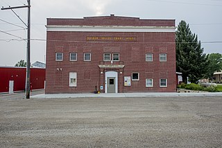
Treasure County is a county in the U.S. state of Montana. As of the 2020 census, the population was 762, making it the second-least populous county in Montana. Its county seat is Hysham. The county was founded in 1919.

<span class="mw-page-title-main">Teton County, Montana</span> County in Montana, United States

Teton County is a county in the U.S. state of Montana. As of the 2020 census, the population was 6,226. Its county seat is Choteau. The county was founded in 1893.

<span class="mw-page-title-main">Sweet Grass County, Montana</span> County in Montana, United States

Sweet Grass County is a county located in the U.S. state of Montana. As of the 2020 census, the population was 3,678. Its county seat is Big Timber. The county was founded in 1895.

<span class="mw-page-title-main">Stillwater County, Montana</span> County in Montana, United States

Stillwater County is a county in the U.S. state of Montana. As of the 2020 census, the population was 8,963. Its county seat is Columbus.

<span class="mw-page-title-main">Powell County, Montana</span> County in Montana, United States

Powell County is a county in the U.S. state of Montana. As of the 2020 census, the population was 6,946. Its county seat is Deer Lodge.

<span class="mw-page-title-main">Pondera County, Montana</span> County in Montana, United States

Pondera County is a county in the U.S. state of Montana. As of the 2020 census, the population was 5,898. Its county seat is Conrad.

<span class="mw-page-title-main">Park County, Montana</span> County in Montana, United States

Park County is a county in the U.S. state of Montana. At the 2020 census, the population was 17,191. Its county seat is Livingston. A small part of Yellowstone National Park is in the southern part of the county.

<span class="mw-page-title-main">Mineral County, Montana</span> County in Montana, United States

Mineral County is a county located in the U.S. state of Montana. As of the 2020 census, the population was 4,535. Its county seat is Superior.

<span class="mw-page-title-main">Granite County, Montana</span> County in Montana, United States

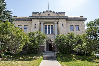
Granite County is a county located in the U.S. state of Montana. As of the 2020 census, the population was 3,309. Its county seat is Philipsburg. The county was founded in 1893, and was named for a mountain which contains the Granite Mountain silver mine.

<span class="mw-page-title-main">Golden Valley County, Montana</span> County in Montana, United States

Golden Valley County is a county located in the U.S. state of Montana. As of the 2020 census, the population was 823, making it the third-least populous county in Montana. Its county seat is Ryegate.

<span class="mw-page-title-main">Garfield County, Montana</span> County in Montana, United States

Garfield County is a county located in the U.S. state of Montana. As of the 2020 census, the population was 1,173. Its county seat is Jordan.

<span class="mw-page-title-main">Gallatin County, Montana</span> County in Montana, United States

Gallatin County is located in the U.S. state of Montana. With its county seat in Bozeman, it is the second-most populous county in Montana, with a population of 118,960 in the 2020 Census.

<span class="mw-page-title-main">Fergus County, Montana</span> County in Montana, United States

Fergus County is a county in the U.S. state of Montana. As of the 2020 census, the population was 11,446. Its county seat is Lewistown. The county was founded in 1885 and named for James Fergus, a Montana politician who was instrumental in creating the county.

<span class="mw-page-title-main">Carter County, Montana</span> County in Montana, United States

Carter County is a county located in the U.S. state of Montana. As of the 2020 census, the population was 1,415, making it the seventh-least populous county in Montana. The county seat is Ekalaka.

<span class="mw-page-title-main">Carbon County, Montana</span> County in Montana, United States

Carbon County is a county located in the U.S. state of Montana. As of the 2020 census, the population was 10,473. Its county seat is Red Lodge.

<span class="mw-page-title-main">West Yellowstone, Montana</span> Town in Montana, United States

West Yellowstone is a town in Gallatin County, Montana, United States, adjacent to Yellowstone National Park. The population was 1,272 at the 2020 census. West Yellowstone is served by Yellowstone Airport. It is part of the Bozeman, MT Micropolitan Statistical Area.

<span class="mw-page-title-main">Musselshell, Montana</span> CDP in Montana, United States

Musselshell is an unincorporated village in Musselshell County, Montana, United States. It is also the namesake of a census designated place (CDP) which incorporates the village. The population of the village is unknown, but the population of the entire CDP was 60 at the 2010 census. The village is located near the Musselshell River.

<span class="mw-page-title-main">Worden, Montana</span> CDP in Montana, United States

Worden is a census-designated place (CDP) in Yellowstone County, Montana, United States. The population was 582 at the 506 at the 2020 census. Worden, along with Ballantine, Huntley, and Pompey's Pillar, is part of the Huntley Project, an irrigation district established by the United States Bureau of Reclamation in 1907.

<span class="mw-page-title-main">Petroleum County, Montana</span> County in Montana, United States

Petroleum County is a county in the U.S. state of Montana. As of the 2020 census, the population was 496, making it the least populous county in Montana and the eighth-least populous in the United States. Its county seat is Winnett. The county's area was partitioned from Fergus County in 1925 to become the last of Montana's 56 counties to be organized.

References

  1. 1 2 About Musselshell County
  2. The NaCo site lists county area as 1,871 sq. miles; the Census Bureau site lists 1,867.15; the Musselshell County website shows 1,965.
  3. 1 2 "State & County QuickFacts". United States Census Bureau. Retrieved May 8, 2023.
  4. "Find a County". National Association of Counties. Retrieved June 7, 2011.
  5. "2010 Census Gazetteer Files". United States Census Bureau. August 22, 2012. Archived from the original on December 5, 2014. Retrieved January 4, 2019.
  6. Leip, David. "Atlas of US Presidential Elections". uselectionatlas.org. Retrieved April 3, 2018.
  7. The leading "other" candidate, Progressive Theodore Roosevelt, received 400 votes, while Socialist candidate Eugene Debs received 215 votes.
  8. "Annual Estimates of the Resident Population for Counties: April 1, 2020 to July 1, 2022". United States Census Bureau. Retrieved May 8, 2023.
  9. "U.S. Decennial Census". United States Census Bureau. Retrieved November 29, 2014.
  10. "Historical Census Browser". University of Virginia Library. Retrieved November 29, 2014.
  11. "Population of Counties by Decennial Census: 1900 to 1990". United States Census Bureau. Retrieved November 29, 2014.
  12. "Census 2000 PHC-T-4. Ranking Tables for Counties: 1990 and 2000" (PDF). US Census Bureau. Archived (PDF) from the original on March 27, 2010. Retrieved November 29, 2014.
  13. Delphia MT Google Maps (accessed January 4, 2019)
  14. Elso, MT Google Maps (accessed January 4, 2019)
  15. Queens Point MT Google Maps (accessed January 4, 2019)

46°29′N108°24′W / 46.49°N 108.40°W / 46.49; -108.40