Camp Three, Montana

Last updated

Camp Three, Montana
Musselshell County Montana Incorporated and Unincorporated areas Camp Three Highlighted.svg
Location in Musselshell County and the state of Montana
Coordinates: 46°26′31″N108°33′58″W / 46.44194°N 108.56611°W / 46.44194; -108.56611
Country United States
State Montana
County Musselshell
Area
[1]
  Total4.45 sq mi (11.54 km2)
  Land4.45 sq mi (11.54 km2)
  Water0.00 sq mi (0.00 km2)
Elevation
3,225 ft (983 m)
Population
 (2020) [2]
  Total138
  Density30.98/sq mi (11.96/km2)
Time zone UTC-7 (Mountain (MST))
  Summer (DST) UTC-6 (MDT)
ZIP Code
59072 (Roundup)
Area code 406
FIPS code 30-11995
GNIS feature ID1853176

Camp Three is a rural census-designated place (CDP) in Musselshell County, Montana, United States. The population was 138 at the 2020 census, [2] down from 173 in 2010. [3]

Contents

Geography

The community is in west-central Musselshell County, next to the western border of the city of Roundup, the county seat. U.S. Route 87 runs along the eastern border of the CDP north of Roundup, and Routes 87 and 12 run through the southern part of the CDP after passing through the center of Roundup. The southern border of the CDP follows the Musselshell River, a northeast-flowing tributary of the Missouri River.

According to the U.S. Census Bureau, the Camp Three CDP has a total area of 4.45 square miles (11.5 km2), all land. [1]

Demographics

Historical population
CensusPop.Note
2000 138
2010 17325.4%
2020 138−20.2%
U.S. Decennial Census [4]

As of the census [5] of 2000, there were 138 people, 77 households, and 35 families residing in the CDP. The population density was 31.2 inhabitants per square mile (12.0/km2). There were 104 housing units at an average density of 23.5 per square mile (9.1/km2). The racial makeup of the CDP was 95.65% White, 1.45% Native American, 1.45% Asian, and 1.45% from two or more races. Hispanic or Latino of any race were 0.72% of the population.

There were 77 households, out of which 11.7% had children under the age of 18 living with them, 39.0% were married couples living together, 3.9% had a female householder with no husband present, and 54.5% were non-families. 45.5% of all households were made up of individuals, and 20.8% had someone living alone who was 65 years of age or older. The average household size was 1.79 and the average family size was 2.49.

In the CDP, the population was spread out, with 11.6% under the age of 18, 6.5% from 18 to 24, 23.2% from 25 to 44, 34.8% from 45 to 64, and 23.9% who were 65 years of age or older. The median age was 51 years. For every 100 females, there were 102.9 males. For every 100 females age 18 and over, there were 100.0 males.

The median income for a household in the CDP was $17,212, and the median income for a family was $30,714. Males had a median income of $18,636 versus $13,750 for females. The per capita income for the CDP was $11,767. There were 11.9% of families and 20.3% of the population living below the poverty line, including 53.8% of under eighteens and 4.7% of those over 64.

Related Research Articles

<span class="mw-page-title-main">Mesquite Creek, Arizona</span> CDP in Mohave County, Arizona

Mesquite Creek is an unincorporated community and census-designated place (CDP) in Mohave County, Arizona, United States. The population was 403 at the 2020 census.

<span class="mw-page-title-main">South Bradenton, Florida</span> Census-designated place in Florida, United States

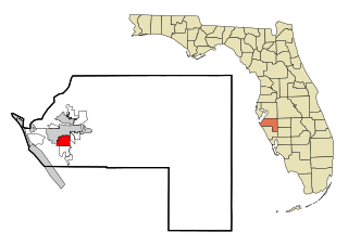
South Bradenton is an unincorporated community and census-designated place (CDP) in Manatee County, Florida, United States. The population was 26,858 at the 2020 census, up from 22,178 in 2010. It is part of the North Port–Bradenton–Sarasota, Florida Metropolitan Statistical Area.

<span class="mw-page-title-main">Homestead Base, Florida</span> Census-designated place in Florida

Homestead Base is a census-designated place (CDP) in Miami-Dade County, Florida, United States. The CDP comprises the extent of Homestead Air Reserve Base plus some surrounding land. It is part of the Miami metropolitan area of South Florida. The population was 999 at the 2020 census.

<span class="mw-page-title-main">Ives Estates, Florida</span> Census-designated place in Florida

Ives Estates is a census-designated place (CDP) in Miami-Dade County, Florida. It is part of the Miami metropolitan area of South Florida. The population was 25,005 at the 2020 census, up from 19,525 in 2010.

<span class="mw-page-title-main">Palmetto Estates, Florida</span> Census-designated place in Florida

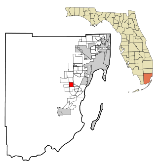
Palmetto Estates is an unincorporated area and census-designated place (CDP) in Miami-Dade County, Florida, United States. It is part of the Miami metropolitan area of South Florida. The population was 13,498 at the 2020 census.

<span class="mw-page-title-main">Pinewood, Florida</span> Census-designated place in Florida

Pinewood is an unincorporated community and census-designated place (CDP) in Miami-Dade County, Florida, United States. It is part of the Miami metropolitan area of South Florida. The population was 17,246 at the 2020 census.

<span class="mw-page-title-main">Three Lakes, Florida</span> Census-designated place in Florida

Three Lakes is a census-designated place (CDP) and planned community in Miami-Dade County, Florida, United States. It is part of the Miami metropolitan area of South Florida. The population was 16,540 at the 2020 census, up from 15,047 in 2010.

<span class="mw-page-title-main">West Perrine, Florida</span> Census-designated place in Florida

West Perrine is a census-designated place (CDP) in Miami-Dade County, Florida, United States. It is part of the Miami metropolitan area of South Florida. The population was 10,602 at the 2020 census, up from 9,460 in 2010.

<span class="mw-page-title-main">Canada Creek Ranch, Michigan</span> Census-designated place in Michigan, United States

Canada Creek Ranch is an unincorporated community in Montmorency Township, Montmorency County, in the U.S. state of Michigan. It is a census-designated place (CDP) used for statistical purposes. The population was 258 at the 2020 census, down from 304 in 2010.

<span class="mw-page-title-main">Riverbend, Montana</span> Census-designated place in Montana, United States

Riverbend is an unincorporated community and census-designated place (CDP) in Mineral County, Montana, United States. The population was 455 at the 2020 census. The community uses the ZIP Code of neighboring Superior, 59872.

<span class="mw-page-title-main">Clinton, Montana</span> Census-designated place in Montana, United States

Clinton is an unincorporated community and census-designated place (CDP) in Missoula County, Montana, United States. It is part of the Missoula metropolitan area. The population was 1,018 at the 2020 census.

<span class="mw-page-title-main">East Missoula, Montana</span> Census-designated place in Montana, United States

East Missoula is an unincorporated community and census-designated place (CDP) in Missoula County, Montana, United States. It is part of the Missoula metropolitan area. The population was 2,465 at the 2020 census, up from 2,157 in 2010.

<span class="mw-page-title-main">Evaro, Montana</span> Census-designated place in Montana, United States

Evaro is a census-designated place (CDP) in Missoula County, Montana, United States, and part of the Missoula metropolitan area. It is located on the southernmost part of the Flathead Indian Reservation, approximately 20 miles (32 km) north of downtown Missoula via US Highway 93. As of the 2020 census, the population of the CDP was 373, up from 322 in 2010.

<span class="mw-page-title-main">Orchard Homes, Montana</span> Census-designated place in Montana, United States

Orchard Homes is a census-designated place (CDP) in Missoula County, Montana, United States. It is part of the Missoula metropolitan area. The population was 5,377 at the 2020 census.

<span class="mw-page-title-main">Wye, Montana</span> Census-designated place in Montana, United States

Wye is an unincorporated community and census-designated place in Missoula County, Montana, United States. It is part of the Missoula metropolitan area. The population was 714 at the 2020 census, up from 511 in 2010. The community is named for the "y"-shaped DeSmet Junction where US 93 and MT 200 met former US 10.

<span class="mw-page-title-main">Klein, Montana</span> CDP in Montana, United States

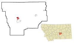
Klein is a census-designated place (CDP) in Musselshell County, Montana, United States. The population was 163 at the 2020 census.

<span class="mw-page-title-main">Melstone, Montana</span> Town in Montana, United States

Melstone is a rural small town in far eastern Musselshell County, Montana, United States, along U.S. Route 12. The population was 126 at the 2020 census. The town was established in 1908 as a base for operating crews on the Chicago, Milwaukee, St. Paul and Pacific Railroad, then under construction in Montana. Although the railroad was abandoned in 1980, Melstone survives as a community center for farmers and ranchers in the lower Musselshell River valley.

<span class="mw-page-title-main">Musselshell, Montana</span> CDP in Montana, United States

Musselshell is an unincorporated village in Musselshell County, Montana, United States. It is also the namesake of a census designated place (CDP) which incorporates the village. The population of the village is unknown, but the population of the entire CDP was 60 at the 2010 census. The village is located near the Musselshell River.

<span class="mw-page-title-main">Roundup, Montana</span> City in Montana, United States

Roundup is a city in and the county seat of Musselshell County, Montana, United States. The population was 1,742 as of the 2020 census.

<span class="mw-page-title-main">South Miami Heights, Florida</span> Census-designated place in Florida

South Miami Heights is a census-designated place (CDP), originally known as Eureka, in Miami-Dade County, Florida. It is part of the Miami metropolitan area of South Florida. The population was 36,770 as of the 2020 census.

References

  1. 1 2 "2023 U.S. Gazetteer Files: Montana". United States Census Bureau. Retrieved June 12, 2024.
  2. 1 2 "P1. Race – Camp Three CDP, Montana: 2020 DEC Redistricting Data (PL 94-171)". U.S. Census Bureau. Retrieved June 12, 2024.
  3. "P1. Race – Camp Three CDP, Montana: 2010 DEC Redistricting Data (PL 94-171)". U.S. Census Bureau. Retrieved June 12, 2024.
  4. "Census of Population and Housing". Census.gov. Retrieved June 4, 2016.
  5. "U.S. Census website". United States Census Bureau . Retrieved January 31, 2008.