Musselshell, Montana

Last updated

Musselshell, Montana
Musselshell County Montana Incorporated and Unincorporated areas Musselshell Highlighted.svg
Location in Musselshell County and the state of Montana
Coordinates: 46°31′1″N108°5′25″W / 46.51694°N 108.09028°W / 46.51694; -108.09028
Country United States
State Montana
County Musselshell
Area
[1]
  Total2.55 sq mi (6.61 km2)
  Land2.55 sq mi (6.61 km2)
  Water0.00 sq mi (0.00 km2)
Elevation
2,995 ft (913 m)
Population
 (2020) [2]
  Total59
  Density23.13/sq mi (8.93/km2)
Time zone UTC-7 (Mountain (MST))
  Summer (DST) UTC-6 (MDT)
ZIP code
59059
Area code 406
FIPS code 30-52600
GNIS feature ID0774524

Musselshell is an unincorporated community and census-designated place (CDP) in Musselshell County, Montana, United States. The population of the CDP was 59 at the 2020 census. [2] The village is located near the Musselshell River.

Contents

History

In 1866, the Rocky Mountain Wagon Road Company built a trading post named "Kerchival City". Flooding destroyed the post. The Montana Hide and Fur Company later built a post and warehouse on the site and renamed it Musselshell. [3]

Geography

The town is located in eastern Musselshell County, just south of U.S. Route 12. Roundup, the county seat, is 23 miles (37 km) to the west via US 12, and Melston is 12 miles (19 km) to the northeast. Montana Secondary Highway 310 (South Musselshell Road) runs through the center of the community and leads southeast 40 miles (64 km) to Custer and Interstate 94.

According to the U.S. Census Bureau, the Musselshell CDP has a total area of 2.55 square miles (6.6 km2), all land. [1] The Musselshell River, an east-flowing tributary of the Missouri, forms the northern edge of the community, and a tributary, Hawk Creek, runs along the western edge of the community.

Demographics

Historical population
CensusPop.Note
2000 60
2010 600.0%
2020 59−1.7%
U.S. Decennial Census [4]

As of the census [5] of 2000, there were 60 people, 28 households, and 22 families residing in the CDP. The population density was 23.4 inhabitants per square mile (9.0/km2). There were 49 housing units at an average density of 19.1 per square mile (7.4/km2). The racial makeup of the CDP was 100.00% White.

There were 28 households, out of which 17.9% had children under the age of 18 living with them, 71.4% were married couples living together, and 21.4% were non-families. 21.4% of all households were made up of individuals, and 7.1% had someone living alone who was 65 years of age or older. The average household size was 2.14 and the average family size was 2.45.

In the CDP, the population was spread out, with 16.7% under the age of 18, 25.0% from 25 to 44, 25.0% from 45 to 64, and 33.3% who were 65 years of age or older. The median age was 50 years. For every 100 females, there were 106.9 males. For every 100 females age 18 and over, there were 108.3 males.

The median income for a household in the CDP was $23,750, and the median income for a family was $24,219. Males had a median income of $26,250 versus $17,500 for females. The per capita income for the CDP was $8,501. There were 17.4% of families and 23.5% of the population living below the poverty line, including 36.8% of under eighteens and 21.1% of those over 64.

Media

The local newspaper is the Roundup Record-Tribune. [6] It is published weekly and serves Musselshell County and the neighboring counties.

Related Research Articles

<span class="mw-page-title-main">Musselshell County, Montana</span> County in Montana, United States

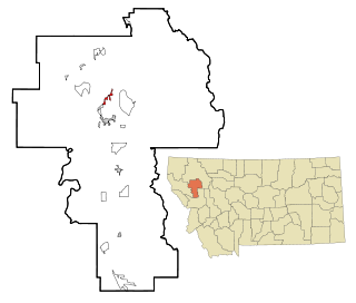
Musselshell County is a county in south-central Montana. As of the 2020 census, the population was 4,730. Its county seat is Roundup.

<span class="mw-page-title-main">St. Xavier, Montana</span> Unincorporated community and census-designated place in Montana, United States

St. Xavier is an unincorporated community and census-designated place (CDP) in Big Horn County, Montana, United States. The CDP population was 83 at the 2010 census.

<span class="mw-page-title-main">Highwood, Montana</span> Census-designated place in Montana, United States

Highwood is an unincorporated community and census-designated place (CDP) in Chouteau County, Montana, United States. The population was 176 at the 2010 census.

<span class="mw-page-title-main">Kremlin, Montana</span> Census-designated place in Montana, United States

Kremlin is an unincorporated community and census-designated place (CDP) in Hill County, Montana, United States. The population was 98 at the 2010 census, down from 126 in 2000.

<span class="mw-page-title-main">Kings Point, Montana</span> Census-designated place in Montana, United States

Kings Point is a census-designated place (CDP) in Lake County, Montana, United States. The population was 151 at the 2010 census, down from 169 in 2000.

<span class="mw-page-title-main">Fortine, Montana</span> Census-designated place in Montana, United States

Fortine is a census-designated place (CDP) in Lincoln County, Montana, United States. The population was 206 at the 2021 census.

<span class="mw-page-title-main">De Borgia, Montana</span> Census-designated place in Montana, United States

De Borgia is an unincorporated community and census-designated place (CDP) in Mineral County, Montana, United States. The population was 91 at the 2020 census.

<span class="mw-page-title-main">Riverbend, Montana</span> Census-designated place in Montana, United States

Riverbend is an unincorporated community and census-designated place (CDP) in Mineral County, Montana, United States. The population was 455 at the 2020 census. The community uses the ZIP Code of neighboring Superior, 59872.

<span class="mw-page-title-main">Clinton, Montana</span> Census-designated place in Montana, United States

Clinton is an unincorporated community and census-designated place (CDP) in Missoula County, Montana, United States. It is part of the Missoula metropolitan area. The population was 1,018 at the 2020 census.

<span class="mw-page-title-main">East Missoula, Montana</span> Census-designated place in Montana, United States

East Missoula is an unincorporated community and census-designated place (CDP) in Missoula County, Montana, United States. It is part of the Missoula metropolitan area. The population was 2,465 at the 2020 census, up from 2,157 in 2010.

<span class="mw-page-title-main">Evaro, Montana</span> Census-designated place in Montana, United States

Evaro is a census-designated place (CDP) in Missoula County, Montana, United States, and part of the Missoula metropolitan area. It is located on the southernmost part of the Flathead Indian Reservation, approximately 20 miles (32 km) north of downtown Missoula via US Highway 93. As of the 2020 census, the population of the CDP was 373, up from 322 in 2010.

<span class="mw-page-title-main">Orchard Homes, Montana</span> Census-designated place in Montana, United States

Orchard Homes is a census-designated place (CDP) in Missoula County, Montana, United States. It is part of the Missoula metropolitan area. The population was 5,377 at the 2020 census.

<span class="mw-page-title-main">Wye, Montana</span> Census-designated place in Montana, United States

Wye is an unincorporated community and census-designated place in Missoula County, Montana, United States. It is part of the Missoula metropolitan area. The population was 714 at the 2020 census, up from 511 in 2010. The community is named for the "y"-shaped DeSmet Junction where US 93 and MT 200 met former US 10.

<span class="mw-page-title-main">Camp Three, Montana</span> Census-designated place in Montana, United States

Camp Three is a rural census-designated place (CDP) in Musselshell County, Montana, United States. The population was 138 at the 2020 census, down from 173 in 2010.

<span class="mw-page-title-main">Klein, Montana</span> Census-designated place in Montana, United States

Klein is a census-designated place (CDP) in Musselshell County, Montana, United States. It contains the unincorporated communities of Klein, Gibbtown, and Farralltown. The population was 163 at the 2020 census.

<span class="mw-page-title-main">Melstone, Montana</span> Town in Montana, United States

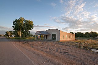
Melstone is a rural small town in far eastern Musselshell County, Montana, United States, along U.S. Route 12. The population was 126 at the 2020 census. The town was established in 1908 as a base for operating crews on the Chicago, Milwaukee, St. Paul and Pacific Railroad, then under construction in Montana. Although the railroad was abandoned in 1980, Melstone survives as a community center for farmers and ranchers in the lower Musselshell River valley.

<span class="mw-page-title-main">Roundup, Montana</span> City in Montana, United States

Roundup is a city in and the county seat of Musselshell County, Montana, United States. The population was 1,742 as of the 2020 census.

<span class="mw-page-title-main">Dayton, Montana</span> Census-designated place in Montana, United States

Dayton is an unincorporated community and census-designated place (CDP) in Lake County, Montana, United States. The population was 84 at the 2010 census.

<span class="mw-page-title-main">Jette, Montana</span> Census-designated place in Montana, United States

Jette is a census-designated place (CDP) in Lake County, Montana, United States. The population was 253 at the 2010 census.

<span class="mw-page-title-main">Joplin, Montana</span> Unincorporated community in Montana, United States

Joplin is an unincorporated community and census-designated place (CDP) in Liberty County, Montana, United States. The population was 157 at the 2010 census.

References

  1. 1 2 "2023 U.S. Gazetteer Files: Montana". United States Census Bureau. Retrieved June 13, 2024.
  2. 1 2 "P1. Race – Musselshell CDP, Montana: 2020 DEC Redistricting Data (PL 94-171)". U.S. Census Bureau. Retrieved June 13, 2024.
  3. "Musselshell". Montana Place Names Companion. Montana Historical Society. Retrieved April 7, 2021.
  4. "Census of Population and Housing". Census.gov. Retrieved June 4, 2016.
  5. "U.S. Census website". United States Census Bureau . Retrieved January 31, 2008.
  6. "News". Roundup Record Tribune & Winnett Times. Retrieved September 7, 2023.