Fallon County, Montana

Last updated

Fallon County
Baker MT Fallon County Courthouse.jpg
Fallon County Courthouse in Baker
Map of Montana highlighting Fallon County.svg
Location within the U.S. state of Montana
Montana in United States.svg
Montana's location within the U.S.
Coordinates: 46°21′N104°25′W / 46.35°N 104.41°W / 46.35; -104.41
CountryFlag of the United States.svg United States
StateFlag of Montana.svg  Montana
FoundedDecember 9, 1913
Seat Baker
Largest cityBaker
Area
  Total1,623 sq mi (4,200 km2)
  Land1,621 sq mi (4,200 km2)
  Water2.3 sq mi (6 km2)  0.1%
Population
 (2020)
  Total3,049
  Estimate 
(2022)
3,011 Decrease2.svg
  Density1.9/sq mi (0.73/km2)
Time zone UTC−7 (Mountain)
  Summer (DST) UTC−6 (MDT)
Congressional district 2nd
Website www.falloncounty.net
  • Montana county number 39

Fallon County is a county located in the U.S. state of Montana. As of the 2020 census, the population was 3,049. [1] Its county seat is Baker. [2] The county was created in 1913 from a portion of Custer County. It is named for Benjamin O'Fallon, a nephew of Captain William Clark and an Indian agent for the upper Missouri region from 1823 to 1827. [3]

Contents

Geography

According to the United States Census Bureau, the county has a total area of 1,623 square miles (4,200 km2), of which 1,621 square miles (4,200 km2) is land and 2.3 square miles (6.0 km2) (0.1%) is water. [4]

Adjacent counties

Politics

United States presidential election results for Fallon County, Montana [5]
Year Republican Democratic Third party
No.%No.%No.%
2020 1,37587.30%17210.92%281.78%
2016 1,27986.19%15410.38%513.44%
2012 1,12880.23%23716.86%412.92%
2008 1,06474.25%31822.19%513.56%
2004 1,17879.01%28919.38%241.61%
2000 1,06177.50%25618.70%523.80%
1996 77851.32%45229.82%28618.87%
1992 73145.46%44627.74%43126.80%
1988 1,00261.25%61237.41%221.34%
1984 1,23767.63%56931.11%231.26%
1980 1,28666.98%51226.67%1226.35%
1976 93451.98%84747.13%160.89%
1972 1,03464.46%53133.10%392.43%
1968 99063.26%47730.48%986.26%
1964 82751.85%76547.96%30.19%
1960 91860.55%59739.38%10.07%
1956 96761.24%61238.76%00.00%
1952 1,04670.01%44029.45%80.54%
1948 67851.02%62346.88%282.11%
1944 87063.46%49436.03%70.51%
1940 92556.96%68642.24%130.80%
1936 59836.00%1,01561.11%482.89%
1932 69039.79%97356.11%714.09%
1928 1,03669.07%45430.27%100.67%
1924 73155.63%22016.74%36327.63%
1920 1,06471.36%38125.55%463.09%
1916 1,16937.54%1,84559.25%1003.21%

Demographics

Historical population
CensusPop.Note
1920 4,548
1930 4,5680.4%
1940 3,719−18.6%
1950 3,660−1.6%
1960 3,9979.2%
1970 4,0501.3%
1980 3,763−7.1%
1990 3,103−17.5%
2000 2,837−8.6%
2010 2,8901.9%
2020 3,0495.5%
2022 (est.)3,011 [6] −1.2%
U.S. Decennial Census [7]
1790–1960, [8] 1900–1990, [9]
1990–2000, [10] 2010–2020 [1]

2020 census

As of the 2020 census, there were 3,049 people living in the county.[ citation needed ]

2010 census

As of the 2010 census, there were 2,890 people, 1,233 households, and 810 families living in the county. The population density was 1.8 inhabitants per square mile (0.69/km2). There were 1,470 housing units at an average density of 0.9 units per square mile (0.35 units/km2). The racial makeup of the county was 97.4% white, 0.6% Asian, 0.4% American Indian, 0.1% Pacific islander, 0.1% black or African American, 0.2% from other races, and 1.3% from two or more races. Those of Hispanic or Latino origin made up 1.2% of the population. In terms of ancestry, 53.0% were German, 24.8% were Irish, 12.1% were Norwegian, 10.6% were English, 5.3% were Scotch-Irish, and 0.4% were American.

Of the 1,233 households, 28.4% had children under the age of 18 living with them, 56.0% were married couples living together, 5.7% had a female householder with no husband present, 34.3% were non-families, and 30.1% of all households were made up of individuals. The average household size was 2.32 and the average family size was 2.88. The median age was 42.9 years.

The median income for a household in the county was $52,529 and the median income for a family was $64,500. Males had a median income of $41,570 versus $30,000 for females. The per capita income for the county was $26,819. About 5.7% of families and 8.5% of the population were below the poverty line, including 16.3% of those under age 18 and 3.4% of those age 65 or over.

Transportation

Major highways

Airport

The Baker Municipal Airport is southeast of Baker. [11]

Communities

Cities

Towns

Unincorporated communities

See also

Related Research Articles

<span class="mw-page-title-main">Harding County, South Dakota</span> County in South Dakota, United States

Harding County is a county in the U.S. state of South Dakota. As of the 2020 census, the population was 1,311, making it the third-least populous county in South Dakota. Its county seat is Buffalo.

<span class="mw-page-title-main">Custer County, South Dakota</span> County in South Dakota, United States

Custer County is a county in the U.S. state of South Dakota. As of the 2020 census, the population was 8,318. Its county seat is Custer. The county was created in 1875, and was organized in 1877. It was named after General George Armstrong Custer.

<span class="mw-page-title-main">Yellowstone County, Montana</span> County in Montana, United States

Yellowstone County is the most populous county in the U.S. state of Montana. As of the 2020 census, the population was 164,731. Its county seat is Billings, the state's most populous city. Like the nearby park, Yellowstone County is named after the Yellowstone River which roughly bisects the county, flowing southwest to northeast. The river, in turn, was named for the yellow sandstone cliffs in what is now Yellowstone County.

<span class="mw-page-title-main">Wibaux County, Montana</span> County in Montana, United States

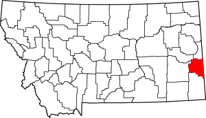
Wibaux County is a county in the U.S. state of Montana. As of the 2020 census, the population was 937, making it the fourth-least populous county in Montana. Its county seat is Wibaux.

<span class="mw-page-title-main">Teton County, Montana</span> County in Montana, United States

Teton County is a county in the U.S. state of Montana. As of the 2020 census, the population was 6,226. Its county seat is Choteau. The county was founded in 1893.

<span class="mw-page-title-main">Sweet Grass County, Montana</span> County in Montana, United States

Sweet Grass County is a county located in the U.S. state of Montana. As of the 2020 census, the population was 3,678. Its county seat is Big Timber. The county was founded in 1895.

<span class="mw-page-title-main">Stillwater County, Montana</span> County in Montana, United States

Stillwater County is a county in the U.S. state of Montana. As of the 2020 census, the population was 8,963. Its county seat is Columbus.

<span class="mw-page-title-main">Roosevelt County, Montana</span> County in Montana, United States

Roosevelt County is a county in the U.S. state of Montana. As of the 2020 census, the population was 10,794. Its county seat is Wolf Point. Roosevelt County was created by the Montana Legislature in 1919 from a portion of Sheridan County. The name honors former president Theodore Roosevelt, who had died earlier that year.

<span class="mw-page-title-main">Richland County, Montana</span> County in Montana, United States

Richland County is a county in the U.S. state of Montana. As of the 2020 census, the population was 11,491. Its county seat is Sidney.

<span class="mw-page-title-main">Prairie County, Montana</span> County in Montana, United States

Prairie County is a county in the U.S. state of Montana. As of the 2020 census, the population was 1,088, making it the fifth-least populous county in Montana. Its county seat is Terry. Prairie County was created by the Montana Legislature in 1915 out of parts of Custer, Dawson, and Fallon Counties. The name was selected in a contest and reflects the predominant landscape of the region.

<span class="mw-page-title-main">Powder River County, Montana</span> County in Montana, United States

Powder River County is a county in the U.S. state of Montana. As of the 2020 census, the population was 1,694. Its county seat is Broadus.

<span class="mw-page-title-main">Pondera County, Montana</span> County in Montana, United States

Pondera County is a county in the U.S. state of Montana. As of the 2020 census, the population was 5,898. Its county seat is Conrad.

<span class="mw-page-title-main">Park County, Montana</span> County in Montana, United States

Park County is a county in the U.S. state of Montana. At the 2020 census, the population was 17,191. Its county seat is Livingston. A small part of Yellowstone National Park is in the southern part of the county.

<span class="mw-page-title-main">Mineral County, Montana</span> County in Montana, United States

Mineral County is a county located in the U.S. state of Montana. As of the 2020 census, the population was 4,535. Its county seat is Superior.

<span class="mw-page-title-main">Jefferson County, Montana</span> County in Montana, United States

Jefferson County is a county in Montana, United States. As of the 2020 census, the population was 12,085. Its county seat is Boulder. The county was created in 1865 and named for President Thomas Jefferson.

<span class="mw-page-title-main">Garfield County, Montana</span> County in Montana, United States

Garfield County is a county located in the U.S. state of Montana. As of the 2020 census, the population was 1,173. Its county seat is Jordan.

<span class="mw-page-title-main">Custer County, Montana</span> County in Montana, United States

Custer County is a county located in the U.S. state of Montana. As of the 2020 census, the population was 11,867. Its county seat is Miles City. The county was established on June 2, 1865, as one of the nine original counties of the Territory of Montana named Big Horn County, and was renamed on February 16, 1877, in honor of Lieutenant Colonel George Armstrong Custer.

<span class="mw-page-title-main">Carter County, Montana</span> County in Montana, United States

Carter County is a county located in the U.S. state of Montana. As of the 2020 census, the population was 1,415, making it the seventh-least populous county in Montana. The county seat is Ekalaka.

<span class="mw-page-title-main">Carbon County, Montana</span> County in Montana, United States

Carbon County is a county located in the U.S. state of Montana. As of the 2020 census, the population was 10,473. Its county seat is Red Lodge.

<span class="mw-page-title-main">Baker, Montana</span> City in Montana, United States

Baker is a city in and the county seat of Fallon County, Montana, United States. The population was 1,802 at the 2020 census.

References

  1. 1 2 "State & County QuickFacts". United States Census Bureau. Retrieved May 9, 2023.
  2. "Find a County". National Association of Counties. Archived from the original on May 31, 2011. Retrieved June 7, 2011.
  3. "Montana Place Names Companion". Montana Place Names From Alzada to Zortman. Montana Historical Society Research Center. Retrieved May 9, 2011.
  4. "2010 Census Gazetteer Files". US Census Bureau. August 22, 2012. Archived from the original on December 5, 2014. Retrieved November 28, 2014.
  5. Leip, David. "Atlas of US Presidential Elections". uselectionatlas.org. Retrieved April 2, 2018.
  6. "Annual Estimates of the Resident Population for Counties: April 1, 2020 to July 1, 2022". United States Census Bureau. Retrieved May 9, 2023.
  7. "U.S. Decennial Census". United States Census Bureau. Retrieved November 28, 2014.
  8. "Historical Census Browser". University of Virginia Library. Retrieved November 28, 2014.
  9. "Population of Counties by Decennial Census: 1900 to 1990". United States Census Bureau. Retrieved November 28, 2014.
  10. "Census 2000 PHC-T-4. Ranking Tables for Counties: 1990 and 2000" (PDF). United States Census Bureau. Archived (PDF) from the original on March 27, 2010. Retrieved November 28, 2014.
  11. FAA Airport Form 5010 for BHK PDF . Federal Aviation Administration. Effective June 30, 2011.
  12. Cabin Creek, Fallon County MT Google Maps (accessed January 1, 2019)
  13. Ollie, Fallon County MT Google Maps (accessed January 1, 2019)
  14. Webster, Fallon County MT Google Maps (accessed January 1, 2019)
  15. Westmore, Fallon County MT Google Maps (accessed January 1, 2019)

46°21′N104°25′W / 46.35°N 104.41°W / 46.35; -104.41