Brockway, Montana

Last updated

Brockway, Montana
USA Montana location map.svg
Red pog.svg
Brockway
Usa edcp location map.svg
Red pog.svg
Brockway
Coordinates: 47°17′59″N105°45′47″W / 47.29972°N 105.76306°W / 47.29972; -105.76306
Country United States
State Montana
County McCone
Area
[1]
  Total0.35 sq mi (0.91 km2)
  Land0.35 sq mi (0.91 km2)
  Water0.00 sq mi (0.00 km2)
Elevation
2,577 ft (785 m)
Population
 (2020) [2]
  Total14
  Density39.77/sq mi (15.36/km2)
Time zone UTC-7 (Mountain (MST))
  Summer (DST) UTC-6 (MDT)
ZIP code
59214
FIPS code 30-10075

Brockway is an unincorporated community and census-designated place (CDP) in southern McCone County, Montana, United States, located near the Redwater River. As of the 2020 census, the first year it was listed as a CDP, the population was 14. [2]

Contents

Brockway is home to the annual Brockway Dairy Day Rodeo.

History

Brockway is named for three homesteader brothers. [3] The post office was opened in 1913. [4] The Northern Pacific Railway's Redwater branch line reached the town in 1928.

The town "became a major livestock shipping point reaching number one in the U.S. in 1934," according to historical marker author Bob Fletcher. [5]

Geography

Brockway is located along Montana Secondary Highway 253, 1 mile (1.6 km) south of Montana Highway 200, along the Big Sky Back Country Byway. [6] [7] It is 12 miles (19 km) southwest of Circle, the McCone county seat.

According to the U.S. Census Bureau, the Brockway CDP has an area of 0.35 square miles (0.91 km2), all land. [1] The Redwater River, a northeast-flowing tributary of the Missouri, passes just west and north of the community.

Demographics

Historical population
CensusPop.Note
2020 14
U.S. Decennial Census [8]

Climate

According to the Köppen Climate Classification system, Brockway has a semi-arid climate, abbreviated "BSk" on climate maps.

Climate data for Brockway, Montana (1991–2020 normals, extremes 1959–present)
MonthJanFebMarAprMayJunJulAugSepOctNovDecYear
Record high °F (°C)68
(20)
71
(22)
84
(29)
91
(33)
101
(38)
110
(43)
108
(42)
108
(42)
104
(40)
94
(34)
78
(26)
68
(20)
110
(43)
Mean daily maximum °F (°C)28.8
(−1.8)
32.5
(0.3)
44.5
(6.9)
56.6
(13.7)
66.7
(19.3)
76.2
(24.6)
85.2
(29.6)
84.8
(29.3)
73.3
(22.9)
57.4
(14.1)
42.6
(5.9)
31.4
(−0.3)
56.7
(13.7)
Daily mean °F (°C)18.0
(−7.8)
21.5
(−5.8)
32.6
(0.3)
43.6
(6.4)
53.5
(11.9)
63.2
(17.3)
70.5
(21.4)
69.5
(20.8)
58.7
(14.8)
44.7
(7.1)
31.1
(−0.5)
20.8
(−6.2)
44.0
(6.7)
Mean daily minimum °F (°C)7.2
(−13.8)
10.5
(−11.9)
20.7
(−6.3)
30.7
(−0.7)
40.4
(4.7)
50.1
(10.1)
55.8
(13.2)
54.3
(12.4)
44.0
(6.7)
31.9
(−0.1)
19.5
(−6.9)
10.2
(−12.1)
31.3
(−0.4)
Record low °F (°C)−44
(−42)
−47
(−44)
−36
(−38)
−9
(−23)
12
(−11)
24
(−4)
33
(1)
25
(−4)
14
(−10)
−10
(−23)
−35
(−37)
−43
(−42)
−47
(−44)
Average precipitation inches (mm)0.24
(6.1)
0.18
(4.6)
0.29
(7.4)
1.16
(29)
2.48
(63)
2.54
(65)
2.07
(53)
1.14
(29)
1.08
(27)
0.86
(22)
0.21
(5.3)
0.20
(5.1)
12.45
(316)
Average precipitation days (≥ 0.01 in)2.42.22.64.77.27.85.73.63.63.01.71.546.0
Source: NOAA [9] [10]

Related Research Articles

<span class="mw-page-title-main">Tavernier, Florida</span> Census-designated place in Florida, United States

Tavernier is a census-designated place (CDP) and unincorporated community in Monroe County, Florida, United States on Key Largo, the largest island in the upper Florida Keys. Tavernier's population was 2,530 at the 2020 census, up from 2,136 in 2010.

<span class="mw-page-title-main">Big Bay, Michigan</span> Census-designated place & unincorporated community in Michigan, United States

Big Bay is an unincorporated community in Marquette County of the U.S. state of Michigan. It is a census-designated place (CDP) for statistical purposes and does not have any legal status as an incorporated municipality. As of the 2020 census, the CDP had a population of 257, down from 319 in 2010. The community is located within Powell Township near the shore of Big Bay on Lake Superior.

<span class="mw-page-title-main">Fort Smith, Montana</span> Census-designated place in Montana, United States

Fort Smith is a census-designated place (CDP) in Big Horn County, Montana, United States. The population was 161 at the 2010 census. The town is named for the former Fort C.F. Smith. The North District of Bighorn Canyon National Recreation Area is accessed at Fort Smith.

<span class="mw-page-title-main">Lincoln, Montana</span> Census-designated place in Montana, United States

Lincoln is an unincorporated community and census-designated place (CDP) in Lewis and Clark County, Montana, United States. As of the 2010 census, the population was 1,013.

<span class="mw-page-title-main">Alder, Montana</span> Census-designated place in Montana, United States

Alder is an unincorporated community and census-designated place (CDP) in Madison County, Montana, United States. The population was 86 at the 2020 census, down from 103 in 2010. The community takes its name from Alder Creek, the site of the second major gold discovery in Montana.

<span class="mw-page-title-main">Circle, Montana</span> Town in Montana, United States

Circle is a town in and the county seat of McCone County, Montana, United States. The population was 591 at the 2020 census.

<span class="mw-page-title-main">Lipscomb, Texas</span> Census-designated place in Texas, United States

Lipscomb is an unincorporated community and census-designated place (CDP) in Lipscomb County, Texas, United States. It is the Lipscomb county seat. The population was 37 at the 2010 census.

<span class="mw-page-title-main">Baring, Washington</span> Census-designated place in Washington, United States

Baring is an unincorporated community and census-designated place (CDP) in King County, Washington, United States. The population was 255 at the 2020 census, up from 220 at the 2010 census. It is located on U.S. Highway 2 about 23 miles (37 km) west of Stevens Pass, along a very flat and straight three-mile section of highway that has been dubbed the "Baring Straight", since US-2 is otherwise hilly and curvy through the mountains. The settlement was first known as "Salmon", but by 1909 it was known as Baring.

<span class="mw-page-title-main">Big Sky, Montana</span> Census-designated place in Montana, United States

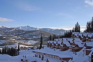
Big Sky is an unincorporated community and census-designated place (CDP) in Gallatin and Madison counties in southwestern Montana, United States. As of the 2020 census, it had a population of 3,591, up from 2,308 in 2010. It is 44 miles (71 km) by road southwest of Bozeman. The primary industry of the area is tourism.

<span class="mw-page-title-main">Alzada, Montana</span> Census-designated place in Montana, United States

Alzada is a census-designated place in southern Carter County, Montana, United States. As of the 2010 census it had a population of 29. It is located at the intersection of U.S. Route 212 with Montana Secondary Highways 323 and 326, near the Wyoming and South Dakota borders. The Little Missouri River flows northwards to the west of the community. Alzada is in the Mountain Time Zone.

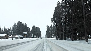
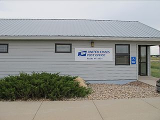
Vida is an unincorporated village and census-designated place (CDP) in northern McCone County, Montana, United States, located on Montana Highway 13 along the Big Sky Back Country Byway, approximately 23 miles (37 km) south of Wolf Point, and 30 miles (48 km) north of Circle. As of the 2020 census, the population of Vida was 24.

<span class="mw-page-title-main">Cooke City, Montana</span> Census-designated place in Montana, United States

Cooke City is an unincorporated community and census-designated place (CDP) in Park County, Montana, United States. As of the 2020 census, it had a population of 77. Prior to 2010, it was part of the Cooke City-Silver Gate CDP.

Caesars Head is an unincorporated community and census-designated place (CDP) on top of Caesars Head, a mountain in Greenville County, South Carolina, United States. It was first listed as a CDP in the 2020 census with a population of 84.

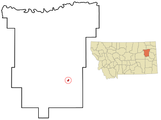
Savage is an unincorporated community and census-designated place (CDP) in Richland County, Montana, United States. Savage is located on the Yellowstone River and Montana Highway 16, 20 miles (32 km) south-southwest of Sidney.

Roosevelt is a census-designated place (CDP) in Gila County, Arizona, United States. The population was 28 at the 2010 census.

<span class="mw-page-title-main">Montana Highway 13</span> State highway in McCone, Roosevelt, and Daniels counites in Montana, United States

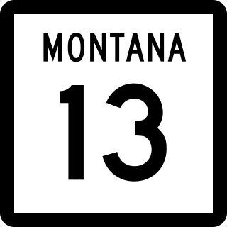
Montana Highway 13 (MT 13) is a 112-mile (180 km) state highway in the east of the U.S. state of Montana. The highway begins at its southern end at MT 200 and connects the three county seats of McCone, Roosevelt and Daniels counties. It also provides access across the northern international border into Saskatchewan, towards Moose Jaw, at the Port of Scobey.

<span class="mw-page-title-main">Sula, Montana</span> Census-designated place in Montana, United States

Sula is a census-designated place (CDP) in Ravalli County, Montana, United States. It is named after the community of Sula, which it encompasses, and was established about 2010, prior to that year's census. The population of the CDP was 37 at the 2010 census.

Swan Lake is a census-designated place and unincorporated community in Lake County, Montana, United States. Its population was 113 as of the 2010 census.

Potomac is an unincorporated community and census-designated place (CDP) in Missoula County, Montana, United States. It is in the southeastern part of the county, in the valley of Camas Creek and Union Creek, which flows northwest to the Blackfoot River, part of the Clark Fork watershed.

Lybrook is an unincorporated community and census-designated place (CDP) in Rio Arriba County, New Mexico, United States. It was first listed as a CDP prior to the 2020 census.

References

  1. 1 2 "2023 U.S. Gazetteer Files: Montana". United States Census Bureau. Retrieved May 17, 2024.
  2. 1 2 "P1. Race – Brockway CDP, Montana: 2020 DEC Redistricting Data (PL 94-171)". U.S. Census Bureau. Retrieved May 17, 2024.
  3. "Montana Place Names Companion". Montana Historical Society. Retrieved July 29, 2017.
  4. Carkeek Cheney, Roberta (1983). Names on the Face of Montana. Missoula, Montana: Mountain Press Publishing Company. ISBN   0-87842-150-5.
  5. Wilson, Kurt (November 2, 2014). "Roadside Wanderings: Resilient northeastern Montana". Missoulian. Retrieved November 2, 2014.
  6. "Big Sky Back Country Byway". Federal Highway Administration, United States Department of Transportation. Archived from the original on July 31, 2012. Retrieved January 30, 2007.
  7. "Big Sky Back Country Byway". Travel Montana, State of Montana . Retrieved January 30, 2007.[ permanent dead link ]
  8. "Census of Population and Housing". Census.gov. Retrieved June 4, 2016.
  9. "NOWData - NOAA Online Weather Data". National Oceanic and Atmospheric Administration. Retrieved December 15, 2023.
  10. "Summary of Monthly Normals 1991-2020". National Oceanic and Atmospheric Administration. Retrieved December 15, 2023.