
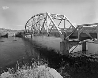
Bonner-West Riverside is a census-designated place (CDP) in Missoula County, Montana, United States, including the unincorporated communities of Bonner, Milltown, West Riverside, and Pinegrove. It is part of the Missoula, Montana Metropolitan Statistical Area. The population was 1,663 at the 2010 census, a decline from its population of 1,693 in 2000.
The Bighorn River is a tributary of the Yellowstone, approximately 461 miles (742 km) long, in the states of Wyoming and Montana in the western United States. The river was named in 1805 by fur trader François Larocque for the bighorn sheep he saw along its banks as he explored the Yellowstone.

The Yellowstone River is a tributary of the Missouri River, approximately 692 miles (1,114 km) long, in the Western United States. Considered the principal tributary of upper Missouri, via its own tributaries it drains an area with headwaters across the mountains and high plains of southern Montana and northern Wyoming, and stretching east from the Rocky Mountains in the vicinity of Yellowstone National Park. It flows northeast to its confluence with the Missouri River on the North Dakota side of the border, about 25 miles west of present-day Williston.

The Flathead Indian Reservation, located in western Montana on the Flathead River, is home to the Bitterroot Salish, Kootenai, and Pend d'Oreilles tribes – also known as the Confederated Salish and Kootenai Tribes of the Flathead Nation. The reservation was created through the July 16, 1855, Treaty of Hellgate.

The Beaverhead River is an approximately 69-mile-long (111 km) tributary of the Jefferson River in southwest Montana. It drains an area of roughly 4,778 square miles (12,370 km2). The river's original headwaters, formed by the confluence of the Red Rock River and Horse Prairie Creek, are now flooded under Clark Canyon Reservoir, which also floods the first 6 miles (9.7 km) of the river. The Beaverhead then flows through a broad valley northward to join the Big Hole River and form the Jefferson River. With the Red Rock River included in its length, the river stretches another 70 miles (110 km), for a total length of 139 miles (224 km), one of the more significant drainages of south-western Montana.

The Madison River is a headwater tributary of the Missouri River, approximately 183 miles (295 km) long, in Wyoming and Montana. Its confluence with the Jefferson and Gallatin rivers near Three Forks, Montana forms the Missouri River.

The Clark Fork, or the Clark Fork of the Columbia River, is a river in the U.S. states of Montana and Idaho, approximately 310 miles (500 km) long. The largest river by volume in Montana, it drains an extensive region of the Rocky Mountains in western Montana and northern Idaho in the watershed of the Columbia River. The river flows northwest through a long valley at the base of the Cabinet Mountains and empties into Lake Pend Oreille in the Idaho Panhandle. The Pend Oreille River in Idaho, Washington, and British Columbia, Canada which drains the lake to the Columbia in Washington, is sometimes included as part of the Clark Fork, giving it a total length of 479 miles (771 km), with a drainage area of 25,820 square miles (66,900 km2). In its upper 20 miles (32 km) in Montana near Butte, it is known as Silver Bow Creek. Interstate 90 follows much of the upper course of the river from Butte to Saint Regis. The highest point within the river's watershed is Mount Evans at 10,641 feet (3,243 m) in Deer Lodge County, Montana along the Continental Divide.

Pictograph Cave is an area of three caves located 5 miles (8.0 km) south of Billings, Montana, United States, preserved and protected in the 23-acre (9.3 ha) Pictograph Cave State Park.
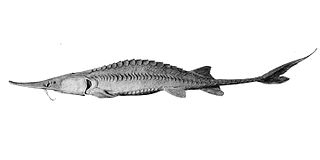
The pallid sturgeon is an endangered species of ray-finned fish, endemic to the waters of the Missouri and lower Mississippi river basins of the United States.

Missouri Headwaters State Park is a public recreation area occupying 535 acres (217 ha) at the site of the official start of the Missouri River. The park offers camping, hiking trails, hunting, and water-related activities. It is located on Trident Road northeast of Three Forks, Montana at an elevation of 4,045 feet (1,233 m). The park includes the Three Forks of the Missouri National Historic Landmark, designated in 1960 because the site is one where the Lewis and Clark Expedition camped in 1805.

The Crooked River is a tributary, 125 miles (201 km) long, of the Deschutes River in the U.S. state of Oregon. The river begins at the confluence of the South Fork Crooked River and Beaver Creek. Of the two tributaries, the South Fork Crooked River is the larger and is sometimes considered part of the Crooked River proper. A variant name of the South Fork Crooked River is simply "Crooked River". The Deschutes River flows north into the Columbia River.
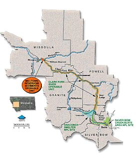
The Milltown Reservoir Sediments Superfund Site is a major Superfund site in Missoula County, Montana, seven miles east of Missoula. It was added to the National Priorities List in 1983 when arsenic groundwater contamination was found in the Milltown area. The contamination resulted from a massive flood three years after its construction in 1905, which washed millions of tons of mine waste into the Clark Fork River, ultimately ending up behind the Milltown Dam.

Holter Dam is a hydroelectric straight gravity dam on the Missouri River about 45 miles (72 km) northeast of Helena, Montana, in the United States. The dam, which was built between 1908 and 1918, is 1,364 feet (416 m) long and 124 feet (38 m) high. The reservoir formed by the dam, Holter Lake is 25 miles (40 km) long and has a storage capacity of 243,000 acre-feet (300,000,000 m3) of water when full. The dam is a "run-of-the-river" dam because it can generate electricity without needing to store additional water supplies behind the dam.

Black Sandy State Park is a public recreation area on the western shore of Hauser Lake reservoir, an impoundment of the Missouri River, located thirteen miles (21 km) northeast of Helena in Lewis and Clark County, Montana, in the United States. The park is along the Lewis and Clark National Historic Trail.

The Tongue River Dam is a dam in Big Horn County, Montana, a few miles north of the Wyoming state border. It impounds the Tongue River, creating the Tongue River Reservoir.
Cooney State Park is a public recreation area bordering Cooney Reservoir, fourteen miles (23 km) south of Columbus in Carbon County, Montana. The state park occupies 309 acres (125 ha) on three sides of the reservoir, a 1,078-acre (436 ha) impoundment of Red Lodge Creek completed in 1937. The park offers boating, fishing, swimming, picnicking, and camping.
Ackley Lake State Park is a public recreation area located four miles southwest of Hobson, Montana. The state park covers 290 acres (120 ha) centered around 160-acre (65 ha) Ackley Lake. The Little Belt Mountains and Snowy Mountains are visible on the horizon. The park is operated by the Montana Department of Fish, Wildlife and Parks on land leased from the Montana Department of Natural Resources and Conservation.
Council Grove State Park is a history-oriented, public recreation area located eight miles (13 km) northwest of Missoula in Missoula County, Montana. The site of the park hosted the signing on July 16, 1855, of the Hellgate treaty between representatives of the United States government and members of the Bitterroot Salish, Pend d'Oreille, and the Kootenai to create the Flathead Indian Reservation. A monument commemorates the signing. The park is 187 acres (76 ha) and sits at an elevation of 3,198 feet (975 m). Natural features found in the park are its large, old-growth ponderosa pines, grassy fields, and cottonwood stand by the Clark Fork River. Its recreational features include hiking and fishing.

Silver Bow Creek is a 26-mile-long (42 km) headwater stream of the Clark Fork (river) originating within the city limits of Butte, Montana, from the confluence of Little Basin and Blacktail Creeks. A former northern tributary, Yankee Doodle Creek, no longer flows directly into Silver Bow Creek as it is now captured by the Berkeley Pit. Silver Bow Creek flows northwest and north through a high mountain valley, passing east of Anaconda, Montana, where it becomes the Clark Fork at the confluence with Warm Springs Creek.
Pirogue Island State Park is a public recreation area on an island in the Yellowstone River, two miles north of Miles City, Montana. The 269-acre (109 ha) state park has 2.8 miles (4.5 km) of designated hiking trails and, according to the Montana Department of Tourism, "[w]ildlife viewing, fishing for sauger, river floating, and Montana moss agate hunting are popular activities."

