Gildford, Montana

Last updated

Gildford, Montana
Gildford Montana downtown.jpg
Downtown Gildford
Hill County Montana Incorporated and Unincorporated areas Gildford Highlighted.svg
Location of Gildford, Montana
Coordinates: 48°34′11″N110°17′50″W / 48.56972°N 110.29722°W / 48.56972; -110.29722
Country United States
State Montana
County Hill
Area
[1]
  Total1.14 sq mi (2.94 km2)
  Land1.14 sq mi (2.94 km2)
  Water0.00 sq mi (0.00 km2)
Elevation
2,831 ft (863 m)
Population
 (2020)
  Total141
  Density124.12/sq mi (47.93/km2)
Time zone UTC-7 (Mountain (MST))
  Summer (DST) UTC-6 (MDT)
ZIP code
59525
Area code 406
FIPS code 30-30700
GNIS feature ID0771771

Gildford is an unincorporated community and census-designated place (CDP) in Hill County, Montana, United States. The population was 179 at the 2010 census. [2]

Contents

The town was named for Guildford, England. [3] A flour mill, which milled Golden Grain Flour, operated from 1915 to 1951. [3]

Geography

Buildings in Gildford Gildford Montana buildings.jpg
Buildings in Gildford

Gildford is located in west-central Hill County at 48°34′11″N110°17′50″W / 48.56972°N 110.29722°W / 48.56972; -110.29722 (48.569785, -110.297115). [4] U.S. Route 2 passes along the southern edge of the community, leading east 29 miles (47 km) to Havre, the county seat, and west 74 miles (119 km) to Shelby.

According to the United States Census Bureau, the CDP has a total area of 5.0 square miles (13 km2), all land.

Climate

Climate data for Gildford, Montana (1991–2020 normals, extremes 1958–present)
MonthJanFebMarAprMayJunJulAugSepOctNovDecYear
Record high °F (°C)65
(18)
75
(24)
79
(26)
89
(32)
97
(36)
103
(39)
111
(44)
110
(43)
110
(43)
89
(32)
77
(25)
66
(19)
111
(44)
Mean daily maximum °F (°C)28.7
(−1.8)
32.3
(0.2)
43.2
(6.2)
55.7
(13.2)
66.0
(18.9)
73.9
(23.3)
83.8
(28.8)
82.4
(28.0)
70.7
(21.5)
55.8
(13.2)
41.0
(5.0)
31.2
(−0.4)
55.4
(13.0)
Daily mean °F (°C)17.1
(−8.3)
20.3
(−6.5)
30.4
(−0.9)
41.8
(5.4)
51.7
(10.9)
59.8
(15.4)
67.1
(19.5)
65.6
(18.7)
55.3
(12.9)
42.1
(5.6)
29.0
(−1.7)
19.6
(−6.9)
41.7
(5.4)
Mean daily minimum °F (°C)5.6
(−14.7)
8.2
(−13.2)
17.6
(−8.0)
28.0
(−2.2)
37.5
(3.1)
45.8
(7.7)
50.3
(10.2)
48.8
(9.3)
39.9
(4.4)
28.4
(−2.0)
17.0
(−8.3)
8.1
(−13.3)
27.9
(−2.3)
Record low °F (°C)−43
(−42)
−44
(−42)
−37
(−38)
−16
(−27)
11
(−12)
29
(−2)
36
(2)
29
(−2)
13
(−11)
−20
(−29)
−30
(−34)
−44
(−42)
−44
(−42)
Average precipitation inches (mm)0.34
(8.6)
0.27
(6.9)
0.29
(7.4)
0.99
(25)
1.77
(45)
2.60
(66)
1.09
(28)
1.05
(27)
1.08
(27)
0.82
(21)
0.47
(12)
0.34
(8.6)
11.11
(282)
Average precipitation days (≥ 0.01 in)3.62.63.25.27.79.34.95.25.04.73.53.057.9
Source: NOAA [5] [6]

School

Historically Gildford had an independent public school district, but consolidated with Kremlin to form the K-G School District in 1971.[ citation needed ] At that time the junior and senior high schools were located in Gildford. Further consolidation occurred in advance of the 2005-06 school year when the K-G School District consolidated with the neighboring Blue Sky School District, forming the North Star Public School District (Districts 99 and M). With this most recent merger, the elementary school is located in Gildford. The junior and senior high schools are now located in Rudyard, Montana. [7] The current mascot for North Star Public Schools is the Knight, [8] with the school colors being black, royal blue, and white.[ citation needed ]

Demographics

Historical population
CensusPop.Note
2020 141
U.S. Decennial Census [9]

As of the census [10] of 2000, there were 185 people, 76 households, and 54 families residing in the CDP. The population density was 36.9 inhabitants per square mile (14.2/km2). There were 86 housing units at an average density of 17.2 per square mile (6.6/km2). The racial makeup of the CDP was 97.84% White, 1.08% Native American, and 1.08% from two or more races.

There were 76 households, out of which 31.6% had children under the age of 18 living with them, 64.5% were married couples living together, 3.9% had a female householder with no husband present, and 28.9% were non-families. 27.6% of all households were made up of individuals, and 13.2% had someone living alone who was 65 years of age or older. The average household size was 2.43 and the average family size was 2.98.

In the CDP, the population was spread out, with 27.0% under the age of 18, 4.9% from 18 to 24, 25.9% from 25 to 44, 21.1% from 45 to 64, and 21.1% who were 65 years of age or older. The median age was 40 years. For every 100 females, there were 92.7 males. For every 100 females age 18 and over, there were 84.9 males.

The median income for a household in the CDP was $33,125, and the median income for a family was $43,750. Males had a median income of $23,125 versus $28,438 for females. The per capita income for the CDP was $17,648. About 4.4% of families and 4.9% of the population were below the poverty line, including none of those under the age of eighteen and 6.1% of those 65 or over.

Transportation

Amtrak’s Empire Builder, which operates between Seattle/Portland and Chicago, passes through the town on BNSF tracks, but makes no stop. The nearest station is located in Havre, 29 miles (47 km) to the east.

Related Research Articles

<span class="mw-page-title-main">Hill County, Montana</span> County in Montana, United States

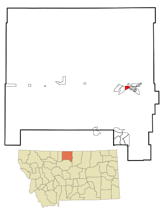
Hill County is a county located in the U.S. state of Montana. As of the 2020 census, the population was 16,309. Its county seat is Havre. It lies along the United States border with Canada, abutting Alberta and Saskatchewan.

<span class="mw-page-title-main">Fort Shaw, Montana</span> CDP in Montana, United States

Fort Shaw is a census-designated place (CDP) in Cascade County, Montana, United States. The population was 280 at the 2010 census. Named for a former United States military outpost, it is part of the Great Falls, Montana Metropolitan Statistical Area.

<span class="mw-page-title-main">Bigfork, Montana</span> Unincorporated community in Montana, United States

Bigfork is a census-designated place (CDP) in Flathead County, Montana, United States. It is within Montana's Rocky Mountains. The population was 5,118 at the 2020 census, up from 4,270 in 2010.

<span class="mw-page-title-main">Starr School, Montana</span> Census-designated place in Montana, United States

Starr School is a census-designated place (CDP) in Glacier County, Montana, United States. The population was 252 at the 2010 census.

<span class="mw-page-title-main">Beaver Creek, Montana</span> Census-designated place in Montana, United States

Beaver Creek is a census-designated place (CDP) in Hill County, Montana, United States. The population was 271 at the 2010 census.

<span class="mw-page-title-main">Havre North, Montana</span> Census-designated place in Montana, United States

Havre North is a census-designated place (CDP) in Hill County, Montana, United States. The population was 716 at the 2010 census, down from 973 in 2000.

<span class="mw-page-title-main">Herron, Montana</span> Census-designated place in Montana, United States

Herron is a census-designated place (CDP) in Hill County, Montana, United States. The population was 43 at the 2010 census.

<span class="mw-page-title-main">Hingham, Montana</span> Town in Montana, United States

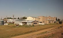
Hingham is a town in Hill County, Montana, United States. Its economy is largely agricultural. The population was 131 at the 2020 census.

<span class="mw-page-title-main">Inverness, Montana</span> CDP in Montana, United States

Inverness is a census-designated place (CDP) in Hill County, Montana, United States. The population was 55 at the 2010 census. It was named after a city in Scotland.

<span class="mw-page-title-main">Kremlin, Montana</span> Census-designated place in Montana, United States

Kremlin is an unincorporated community and census-designated place (CDP) in Hill County, Montana, United States. The population was 98 at the 2010 census, down from 126 in 2000.

<span class="mw-page-title-main">Rudyard, Montana</span> Census-designated place in Montana, United States

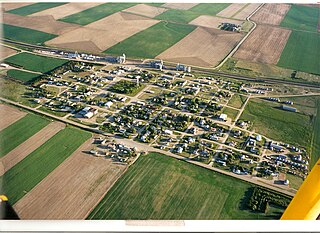
Rudyard is an unincorporated community and census-designated place (CDP) in Hill County, Montana, United States. The population was 258 at the 2010 census.

<span class="mw-page-title-main">Saddle Butte, Montana</span> Census-designated place in Montana, United States

Saddle Butte is a census-designated place (CDP) in Hill County, Montana, United States. The population was 128 at the 2010 census.

<span class="mw-page-title-main">St. Pierre, Montana</span> Census-designated place in Montana, United States

St. Pierre is a census-designated place (CDP) in Hill County, Montana, United States, within the Rocky Boy Indian Reservation. The population of St. Pierre was 350 at the 2010 census, up from 289 in 2000.

<span class="mw-page-title-main">West Havre, Montana</span> Census-designated place in Montana, United States

West Havre is a census-designated place (CDP) in Hill County, Montana, United States. The population was 316 at the 2010 census, up from 284 in 2000.

<span class="mw-page-title-main">Evaro, Montana</span> CDP in Montana, United States

Evaro is a census-designated place (CDP) in Missoula County, Montana, United States, and part of the Missoula Metropolitan Statistical Area. It is located on the southernmost tip of the Flathead Indian Reservation, approximately 12 miles (19 km) north of downtown Missoula and is served by US Highway 93. In 2010, Evaro had a population of 322, a decrease from 329 in 2000.

<span class="mw-page-title-main">Joplin, Montana</span> Unincorporated community in Montana, United States

Joplin is an unincorporated community and census-designated place (CDP) in Liberty County, Montana, United States. The population was 157 at the 2010 census.

<span class="mw-page-title-main">Chula Vista-Orason, Texas</span> Former CDP in Texas, United States

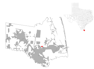
Chula Vista-Orason was a census-designated place (CDP) in Cameron County, Texas, United States. The population was 394 at the 2000 census. For the 2010 census the area was split into two CDPs, Chula Vista and Orason. The communities are part of the Brownsville–Harlingen Metropolitan Statistical Area.

Box Elder is an unincorporated community and census-designated place (CDP) in Hill County in the U.S. state of Montana. The population was 87 at the 2010 census. The population was 794 at the 2000 census, but before 2010 the Box Elder CDP was split into the current much-smaller Box Elder CDP, while most of the former CDP area went into the new Rocky Boy West CDP. Box Elder is the headquarters of the Chippewa-Cree tribe.

<span class="mw-page-title-main">Oljato-Monument Valley, Arizona</span> CDP in Navajo County, Arizona

Oljato-Monument Valley is a census-designated place (CDP) in Navajo County, Arizona, United States. The population was 154 at the 2010 census.

<span class="mw-page-title-main">Power, Montana</span> CDP in Montana, United States

Power is a census-designated place (CDP) in Teton County, Montana, United States. The population was 171 at the 2000 census. The town is named after Montana pioneer, Thomas Charles Power, who platted the townsite in 1910.

References

  1. "ArcGIS REST Services Directory". United States Census Bureau. Retrieved September 5, 2022.
  2. "Geographic Identifiers: 2010 Census Summary File 1 (G001): Gildford CDP, Montana". American Factfinder. U.S. Census Bureau. Archived from the original on February 13, 2020. Retrieved August 22, 2017.
  3. 1 2 "Guildford". Montana Place Names Companion. Montana Historical Society. Retrieved April 3, 2021.
  4. "US Gazetteer files: 2010, 2000, and 1990". United States Census Bureau. February 12, 2011. Retrieved April 23, 2011.
  5. "NOWData - NOAA Online Weather Data". National Oceanic and Atmospheric Administration. Retrieved December 14, 2023.
  6. "Summary of Monthly Normals 1991-2020". National Oceanic and Atmospheric Administration. Retrieved December 14, 2023.
  7. "Directory of Montana Schools, 2006-2007" (PDF). Montana Office of Public Instruction. Archived from the original (PDF) on June 29, 2007. Retrieved August 19, 2007.
  8. "Montana High School Association - Member Schools". Montana High School Association. Archived from the original on September 24, 2007. Retrieved August 19, 2007.
  9. "Census of Population and Housing". Census.gov. Retrieved June 4, 2016.
  10. "U.S. Census website". United States Census Bureau . Retrieved January 31, 2008.