
Montana is a state in the Mountain West subregion of the Western United States. It is bordered by Idaho to the west; North Dakota and South Dakota to the east; Wyoming to the south; and by the Canadian provinces of Alberta, British Columbia, and Saskatchewan to the north. It is the fourth-largest state by area, the eighth-least populous state, and the third-least densely populated state. Its state capital is Helena. The western half of Montana contains numerous mountain ranges, while the eastern half is characterized by western prairie terrain and badlands, with smaller mountain ranges found throughout the state. In all, 77 named ranges are part of the Rocky Mountains.

Park County is a county in the U.S. state of Montana. At the 2020 census, the population was 17,191. Its county seat is Livingston. A small part of Yellowstone National Park is in the southern part of the county.

Gallatin County is located in the U.S. state of Montana. With its county seat in Bozeman, it is the second-most populous county in Montana, with a population of 118,960 in the 2020 Census.

Gallatin is a city in Daviess County, Missouri, United States. The population was 1,821 at the 2020 census. It is the county seat of Daviess County.

Belgrade is a city in Gallatin County, Montana, United States. The population was 10,460 at the 2020 census. It is the largest city in Montana that is not a county seat.

Bozeman is a city and the county seat of Gallatin County, Montana, United States. Located in southwest Montana, the 2020 census put Bozeman's population at 53,293, making it the fourth-largest city in Montana. It is the principal city of the Bozeman, MT Micropolitan Statistical Area, consisting of all of Gallatin County with a population of 118,960. Due to the fast growth rate Bozeman is expected to be upgraded to Montana's fourth metropolitan area. It is the largest micropolitan statistical area in Montana, the fastest growing micropolitan statistical area in the United States in 2018, 2019 and 2020, as well as the third-largest of all Montana's statistical areas.

Four Corners is a census-designated place (CDP) in Gallatin County, Montana, United States. The population was 3,146 at the 2010 census, up from 1,828 in 2000. It is part of the Bozeman, MT Micropolitan Statistical Area.

Three Forks is a city in Gallatin County, Montana, United States and is located within the watershed valley system of both the Missouri and Mississippi rivers drainage basins — and is historically considered the birthplace or start of the Missouri River. The population was 1,989 at the 2020 census. The city of Three Forks is named so because it lies geographically near the point, in nearby Missouri Headwaters State Park, where the Jefferson, Madison, and Gallatin Rivers converge to form the Missouri River — the longest single river in North America, as well as the major portion of the Missouri-Mississippi River System from the headwaters near Three Forks to its discharge into the Gulf of Mexico. Three Forks is part of the Bozeman, MT Micropolitan Statistical Area of approximately 100,000 people and located thirty miles west of Bozeman.

Willow Creek is a census-designated place (CDP) in Gallatin County, Montana, United States. The population was 210 at the 2010 census. It is part of the Bozeman, MT Micropolitan Statistical Area.
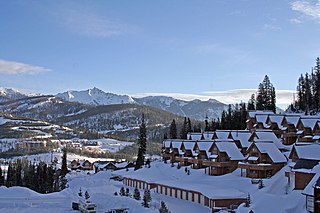
Big Sky is an unincorporated census-designated place (CDP) in Gallatin and Madison counties in southwestern Montana, United States. As of the 2010 census it had a population of 2,308. It is 45 miles (72 km) southwest of Bozeman. This unincorporated community straddles both counties, is not considered a town, and does not have a town government. The primary industry of the area is tourism.
Gallatin Gateway is a census-designated place (CDP) in Gallatin County, Montana, United States. As of the 2010 census it had a population of 856. Elevation is 4,953 ft.
Yellowstone National Park (part) was a former county-equivalent in southwestern Montana, a state in the northwestern United States.

Petroleum County is a county in the U.S. state of Montana. As of the 2020 census, the population was 496, making it the least populous county in Montana and the eighth-least populous in the United States. Its county seat is Winnett. The county's area was partitioned from Fergus County to become the last of Montana's 56 counties to be organized.
Wheatland is a census-designated place (CDP) in Broadwater County, Montana, United States. The population was 568 according to the 2010 census.
Ponderosa Pines is a census-designated place (CDP) in Gallatin County, Montana, United States. The population was 336 at the 2010 census. Formerly a 13,000-acre ranch, the land was subdivided into 10- and 20-acre parcels and sold by a Hawaii real estate agency starting in 1972. The lots lacked water, sewer, electricity and road access, and some were on such steep terrain that building would be impossible.
Springhill is a census-designated place (CDP) in Gallatin County, Montana, United States. The population was 130 at the 2010 census. It is 14 miles north of Bozeman.
Hebgen Lake Estates is a census-designated place (CDP) in Gallatin County, Montana, United States. The population was 70 at the 2010 census. It is next to Hebgen Lake.
King Arthur Park is a census-designated place (CDP) in Gallatin County, Montana, United States. The population was 738 at the 2010 census.

Churchill is a census-designated place (CDP) in Gallatin County, Montana, United States. The population was 902 at the 2010 census. It is part of the Bozeman, MT Micropolitan Statistical Area. It was formerly part of the Amsterdam-Churchill CDP.
Bridger is a census-designated place (CDP) in Gallatin County, Montana, United States. It comprises the Bridger Bowl Ski Area and some nearby residences on the eastern side of the Bridger Range in southwestern Montana. As of the 2010 census the Bridger CDP had a population of 30.


