Bevier, Missouri

Last updated

Bevier, Missouri
Macon County Missouri Incorporated and Unincorporated areas Bevier Highlighted.svg
Location in Macon County and the state of Missouri
Coordinates: 39°44′57″N92°33′50″W / 39.74917°N 92.56389°W / 39.74917; -92.56389
Country United States
State Missouri
County Macon
Area
[1]
  Total1.04 sq mi (2.69 km2)
  Land1.04 sq mi (2.69 km2)
  Water0.00 sq mi (0.00 km2)
Elevation
[2]
843 ft (257 m)
Population
 (2020) [3]
  Total636
  Density612.72/sq mi (236.56/km2)
Time zone UTC-6 (Central (CST))
  Summer (DST) UTC-5 (CDT)
ZIP code
63532
Area code 660
FIPS code 29-05266 [4]
GNIS feature ID2394160 [2]

Bevier is a city in Macon County, Missouri, United States. The population was 636 at the 2020 census, [5] down from 718 in 2010.

Contents

History

Bevier was laid out and platted in 1858 along a new railroad line. [6] [7] The community was named for Kentucky native Robert Bevier, who afterward became a colonel in the Confederate army. [8] A post office called Bevier has been in operation since 1858. [9]

Coal was discovered in Bevier in 1860, and coal mining was an important part of the town economy well into the 20th century. Bevier was incorporated as a village on September 5, 1881, and reorganized as a city on March 16, 1889. [10]

Geography

Bevier is located in south-central Macon County at 39°44′57″N92°33′50″W / 39.74917°N 92.56389°W / 39.74917; -92.56389 (39.749126, -92.563902). [11] U.S. Route 36 passes through the northern extent of the city, with access from Highways C and O. US 36 leads east 5 miles (8 km) to Macon, the county seat, and west 28 miles (45 km) to Brookfield.

According to the U.S. Census Bureau, Bevier has a total area of 1.04 square miles (2.69 km2), all of it recorded as land. [1] An unnamed creek passes through the center of town, flowing west toward the Middle Fork of the Little Chariton River, a south-flowing tributary of the Missouri.

Demographics

Historical population
CensusPop.Note
1870 833
1880 8674.1%
1890 8761.0%
1900 1,808106.4%
1910 1,9005.1%
1920 1,868−1.7%
1930 1,229−34.2%
1940 1,105−10.1%
1950 838−24.2%
1960 781−6.8%
1970 8063.2%
1980 733−9.1%
1990 643−12.3%
2000 72312.4%
2010 718−0.7%
2020 636−11.4%
U.S. Decennial Census [12]

2010 census

As of the census [13] of 2010, there were 718 people, 287 households, and 191 families living in the city. The population density was 697.1 inhabitants per square mile (269.2/km2). There were 341 housing units at an average density of 331.1 per square mile (127.8/km2). The racial makeup of the city was 97.4% White, 1.3% African American, 0.4% Asian, and 1.0% from two or more races. Hispanic or Latino of any race were 0.1% of the population.

There were 287 households, of which 35.9% had children under the age of 18 living with them, 46.0% were married couples living together, 15.3% had a female householder with no husband present, 5.2% had a male householder with no wife present, and 33.4% were non-families. 29.6% of all households were made up of individuals, and 14.6% had someone living alone who was 65 years of age or older. The average household size was 2.50 and the average family size was 3.07.

The median age in the city was 40.1 years. 26.2% of residents were under the age of 18; 8.1% were between the ages of 18 and 24; 23.5% were from 25 to 44; 27% were from 45 to 64; and 15.2% were 65 years of age or older. The gender makeup of the city was 48.2% male and 51.8% female.

2000 census

As of the census [4] of 2000, there were 723 people, 303 households, and 195 families living in the city. The population density was 838.6 inhabitants per square mile (323.8/km2). There were 342 housing units at an average density of 396.7 per square mile (153.2/km2). The racial makeup of the city was 97.65% White, 0.83% Native American, 0.41% Asian, and 1.11% from two or more races. Hispanic or Latino of any race were 0.14% of the population.

There were 303 households, out of which 32.3% had children under the age of 18 living with them, 49.2% were married couples living together, 12.2% had a female householder with no husband present, and 35.6% were non-families. 32.3% of all households were made up of individuals, and 15.5% had someone living alone who was 65 years of age or older. The average household size was 2.39 and the average family size was 3.02.

In the city the population was spread out, with 26.4% under the age of 18, 8.2% from 18 to 24, 27.8% from 25 to 44, 20.2% from 45 to 64, and 17.4% who were 65 years of age or older. The median age was 37 years. For every 100 females there were 96.5 males. For every 100 females age 18 and over, there were 90.0 males.

The median income for a household in the city was $28,250, and the median income for a family was $34,479. Males had a median income of $25,078 versus $17,284 for females. The per capita income for the city was $13,099. About 1.6% of families and 7.6% of the population were below the poverty line, including 5.9% of those under age 18 and 11.0% of those age 65 or over.

Notable people

Related Research Articles

<span class="mw-page-title-main">Macon County, Missouri</span> County in Missouri, United States

Macon County is a county located in the northern portion of the U.S. state of Missouri. As of the 2020 census, the population was 15,209. Its county seat is Macon. The county was organized January 6, 1837, and named for Nathaniel Macon, a Revolutionary War hero and North Carolina politician.

<span class="mw-page-title-main">Alexandria, Missouri</span> City in Missouri, United States

Alexandria is a city in eastern Clark County, Missouri, United States. As of the 2020 census, its population was 105.

<span class="mw-page-title-main">Brandsville, Missouri</span> City in Missouri, United States

Brandsville is a city in southeastern Howell County, Missouri, United States. The population was 161 at the 2010 census.

<span class="mw-page-title-main">Grain Valley, Missouri</span> City in Missouri, United States

Grain Valley is a city in Jackson County, Missouri, United States. Grain Valley is located in the Kansas City Metropolitan Area and is a suburb of Kansas City. The population was 12,854 at the 2010 census and an estimated 15,627 in 2020. It is 23 miles (37 km) east of downtown Kansas City.

<span class="mw-page-title-main">Linneus, Missouri</span> City in Missouri, United States

Linneus is a small city in Linn County, Missouri, United States. The population was 281 at the 2020 census. It is the county seat of Linn County.

<span class="mw-page-title-main">Atlanta, Missouri</span> City in Missouri, United States

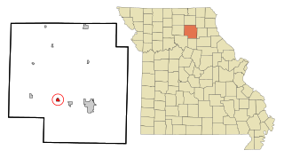
Atlanta is a city in Macon County, Missouri, United States. The population was 379 at the 2020 census.

<span class="mw-page-title-main">Callao, Missouri</span> City in Missouri, United States

Callao is a city in Macon County, Missouri, United States. The population was 251 at the 2020 census, down from 292 in 2010.

<span class="mw-page-title-main">Elmer, Missouri</span> City in Missouri, United States

Elmer is a city in Macon County, Missouri, United States. The population was 51 at the 2020 census, down from 80 in 2010.

<span class="mw-page-title-main">Ethel, Missouri</span> Town in Missouri, United States

Ethel is a town in Macon County, Missouri, United States. The population was 41 at the 2020 census.

<span class="mw-page-title-main">La Plata, Missouri</span> City in Missouri, United States

La Plata is a city in Macon County, Missouri, United States. The population was 1,257 at the 2020 census. La Plata is located next to the Adair County line and is on a mainline of the BNSF Railway. The town is best known for La Plata station, which provides passenger rail service to Chicago and Los Angeles.

<span class="mw-page-title-main">Macon, Missouri</span> City in Missouri, United States

Macon is a city in and the county seat of Macon County, Missouri, United States. The population was 5,457 at the 2020 census.

<span class="mw-page-title-main">New Cambria, Missouri</span> City in Missouri, United States

New Cambria is a city in Macon County, Missouri, United States. The population was 153 at the 2020 census.

<span class="mw-page-title-main">Marston, Missouri</span> City in Missouri, United States

Marston is a city in New Madrid County, Missouri, United States. The population was 503 at the 2010 census.

<span class="mw-page-title-main">Alton, Missouri</span> City in Missouri, United States

Alton is a city and the county seat of Oregon County, Missouri, United States. The population was 707 at the 2020 census.

<span class="mw-page-title-main">Clarence, Missouri</span> City in Missouri, United States

Clarence is a city in western Shelby County, Missouri, United States. The population was 738 at the 2020 census.

<span class="mw-page-title-main">Greendale, Missouri</span> City in Missouri, United States

Greendale is a city in St. Louis County, Missouri, United States. The population was 651 at the 2010 census.

<span class="mw-page-title-main">Dudley, Missouri</span> City in Missouri, United States

Dudley is a city in Stoddard County, Missouri, United States. The population was 232 at the 2010 census.

Myhre Township is a township in Lake of the Woods County, Minnesota, United States. The population was 213 at the 2000 census.

<span class="mw-page-title-main">Clarkson Valley, Missouri</span> City in Missouri, United States

Clarkson Valley is a city in St. Louis County, Missouri, United States. The population was 2,609 at the 2020 census.

Eastlawn Gardens is a census-designated place (CDP) in Upper Nazareth Township in Northampton County, Pennsylvania. The population of Eastlawn Gardens was 3,307 at the 2010 census. Eastlawn Gardens is part of the Lehigh Valley metropolitan area, which had a population of 861,899 and was the 68th-most populous metropolitan area in the U.S. as of the 2020 census.

References

  1. 1 2 "2023 U.S. Gazetteer Files: Missouri". United States Census Bureau. Retrieved March 14, 2024.
  2. 1 2 U.S. Geological Survey Geographic Names Information System: Bevier, Missouri
  3. "P1. Race – Bevier city, Missouri: 2020 DEC Redistricting Data (PL 94-171)". U.S. Census Bureau. Retrieved March 14, 2024.
  4. 1 2 "U.S. Census website". United States Census Bureau . Retrieved January 31, 2008.
  5. "Explore Census Data". data.census.gov. Retrieved February 1, 2022.
  6. Earngey, Bill (1995). Missouri Roadsides: The Traveler's Companion. University of Missouri Press. p. 17. ISBN   9780826210210.
  7. "Macon County Place Names, 1928–1945". The State Historical Society of Missouri. Archived from the original on June 24, 2016. Retrieved October 30, 2016.
  8. Eaton, David Wolfe (1916). How Missouri Counties, Towns and Streams Were Named. The State Historical Society of Missouri. pp.  191.
  9. "Post Offices". Jim Forte Postal History. Retrieved October 30, 2016.
  10. "MU Student Compiles Interesting Notes On Bevier's Early History". Macon [Missouri] Chronicle-Herald. March 12, 1954. p. 5. Retrieved February 17, 2017.
  11. "US Gazetteer files: 2010, 2000, and 1990". United States Census Bureau. February 12, 2011. Retrieved April 23, 2011.
  12. "Census of Population and Housing". Census.gov. Retrieved June 4, 2015.
  13. "U.S. Census website". United States Census Bureau . Retrieved July 8, 2012.