
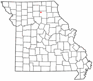
Macon County is a county located in the northern portion of the U.S. state of Missouri. As of the 2020 census, the population was 15,209. Its county seat is Macon. The county was organized January 6, 1837, and named for Nathaniel Macon, a Revolutionary War hero and North Carolina politician.
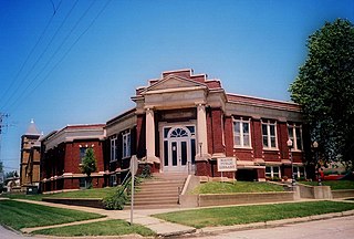
Macon is a city in and the county seat of Macon County, Missouri, United States. The population was 5,457 at the 2020 census.
Goldsberry is an unincorporated community in Macon County, Missouri, United States. The community is located on Route 149, approximately twenty-one miles northwest of Macon. Its post office has closed and mail is now delivered from nearby Ethel.
College Mound is an unincorporated community in southwestern Macon County, Missouri, United States. The community lies approximately 12 miles (19 km) southwest of Macon.
Excello is a census designated place (CDP) in southern Macon County, Missouri, United States. It is located approximately eight miles south of Macon and fifteen miles north of Moberly, one-half mile west of U.S. Route 63 on State Road T.
Barnesville is an unincorporated community in Macon County, in the U.S. state of Missouri.
Barryville is an unincorporated community in Macon County, in the U.S. state of Missouri. The site is approximately 12 miles (19 km) southwest of Macon.
Cottage is an unincorporated community in Macon County, in the U.S. state of Missouri.
Cox is an unincorporated community in Macon County, in the U.S. state of Missouri.
Economy is an unincorporated community in Macon County, in the U.S. state of Missouri.
Hammack is an unincorporated community in Macon County, in the U.S. state of Missouri.
Hart is an extinct village on the Santa Fe Railroad in Russell Township, Macon County, Missouri. The GNIS classifies it as a populated place. A variant name was Evelyn, the name of the local post office. A post office called Evelyn was established in 1888, and remained in operation until 1916. Besides the post office, Hart had a railroad depot.
Kaseyville is an unincorporated community in Macon County, in the U.S. state of Missouri.
Kellogg is an unincorporated community in Macon County, in the U.S. state of Missouri.
Keota is an unincorporated community in Macon County, in the U.S. state of Missouri.
Love Lake is an unincorporated community in Macon County, in the U.S. state of Missouri.
Nickellton is an unincorporated community in Macon County, in the U.S. state of Missouri.
Sue City is an unincorporated community in Macon County, in the U.S. state of Missouri.
Ten Mile is an unincorporated community in Macon County, in the U.S. state of Missouri.
Walnut is an unincorporated community in Macon County, in the U.S. state of Missouri.
This page is based on this
Wikipedia article Text is available under the
CC BY-SA 4.0 license; additional terms may apply.
Images, videos and audio are available under their respective licenses.


