
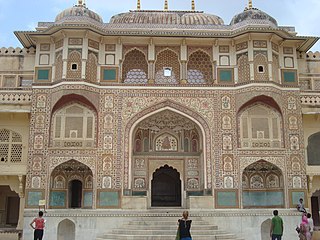
Hanumangarh is a city and municipal council in the Indian state of Rajasthan, situated on the banks of the river Ghaggar also identified as ancient Sarasvati river, located about 400 km from Delhi. It is the administrative headquarter of Hanumangarh District. The city was once called Bhatner because it was founded by king Bhupat in 255 AD. It remained in the control of the Rajputs of Bhati clan and faced a historic siege by Timur in 1391, during which the Bhati Raput king Dulachand lost the fort for a short time. The fort was later occupied by Rao Jetsa of Bikaner.

Sri Ganganagar is the northernmost city of the Indian state of Rajasthan, near the international border of India and Pakistan. It is the administrative headquarters of Sri Ganganagar district. It is named after Maharaja Shri Ganga Singh Bahadur, Maharaja of Bikaner. The city is also known as the "Food Basket of Rajasthan".

Barmer District is a district in Rajasthan state of India. It is located in the western part of Rajasthan state forming a part of the Thar Desert. Barmer is the third largest district by area in Rajasthan and fifth largest district in India, occupying an area of 28,387 km2. Being in the western part of the state, it includes a part of the Thar Desert. Jaisalmer is to the north of this district while Jalore is in its south. Pali and Jodhpur form its eastern border and it shares a border with Pakistan in the west. Partially being a desert, this district has a large variation in temperature. The temperature in summer can rise up to 51 °C and falls near to 0 °C in winter. Luni is the longest river in Barmer district. After travelling a length of almost 500 km, it passes through Jalore and merges in the marshy land of Runn of Kutch. District headquarters is in the town of Barmer. The other major towns in the district are: Balotra, Guda Malani, Baytoo, Siwana, and Chohatan. Recently, a large onshore oil field has been discovered and made functional in Barmer district. Barmer is also famous for pomegranate.
Jaipur District is a district in the state of Rajasthan in Northern India. The city of Jaipur, which is Rajasthan's capital and the largest city, is the district headquarters. It is the tenth most populous district in India.

Nagaur District is one of the 50 districts of the state of Rajasthan in western India. Panchayati Raj was introduced here. It is the fifth largest district in Rajasthan and the area of the district is 17,718 km2 (6,841 sq mi). The city of Nagaur is the district headquarters.

Jodhpur District is a district in the State of Rajasthan in western India. The city of Jodhpur is the administrative headquarters of the district.

Jaisalmer district is the largest district in the Indian state of Rajasthan, and the third largest district in India. Located in Marwar, the city of Jaisalmer is the administrative headquarters of the district. It is around 289 km (180 mi) from the city of Jodhpur, and around 559 km (347 mi) from Jaipur, the capital of Rajasthan. As of the 2011 population census, it is the least populous district out of all 33 districts in Rajasthan.

Churu district is a district of the Indian state of Rajasthan in northern India.

Hanumangarh district is a district in the state of Rajasthan in India. The city of Hanumangarh is the district headquarters and its largest city.
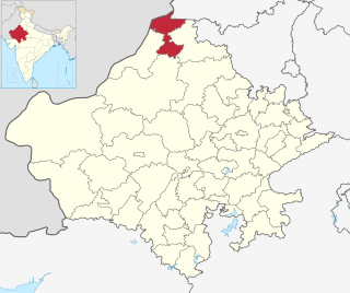
Sri Ganganagar district is the northernmost district of Rajasthan state of India.

Dungargarh (Hindi) is a city and Tehsil in Bikaner district in the state of Rajasthan, India. It is situated at 70 km distance from Bikaner City. Dungargarh is located on the National Highway 11 connecting Jaisalmer(Rajasthan) to Rewari(Haryana).
Sadulshahar is a town and a municipality in Sri Ganganagar district in the Indian state of Rajasthan.

Suratgarh is a City/Tehsil and a municipality in Sri Ganganagar district and is the biggest tehsil among all the 7 tehsils in Sri Ganganagar district. Suratgarh is also known as Cotton city & Bowl of grain of Rajasthan due to high production level of Cotton and wheat in this area. Suratgarh is 77 Km away in South from it district headquarters just nearby Sri Ganganagar city in Sri Ganganagar district in the Indian state of Rajasthan. Founded by Maharaja Surat Singh. Hindi, Bagri and Rajasthani are the widely spoken languages of the city.

Khajuwala is a town in the Bikaner district of Rajasthan, India. It is located near the Indo-Pakistan border and is situated around 113 kilometres (70 mi) from the district headquarters Bikaner. It is an intermediate panchayat with several villages under its administration. It produces a lot of raw cotton and wheat. Indira Gandhi Canal has brought about development of this area. It is a big agro products market in Bikaner district. Earlier its name was Beriyawali. It is also seat in Rajasthan legislative assembly. The current elected Member of Legislative assembly (MLA) from Khajuwala is Govind ram meghwal (INC). Khajuwala has recently been given a status of Panchayat samiti.
Sri Gurusar Modia is a village in the Indian state of Rajasthan situated near borders of Rajasthan, Haryana and Punjab states and the international border of India and Pakistan. This village is located in the tehsil Suratgarh of district Sriganganagar. Suratgarh, once known as Sodhal was believed to be surrounded by the confluence of Saraswati and Drishyati rivers but now the land is a deserted one lying amidst the expanse of The great Indian Thar desert. Suratgarh is famous for its agriculture, air force and army base stations, largest thermal power plant of Rajasthan and largest radio station of Rajasthan called as "Cotton City Channel". Sri Gurusar Modia came into limelight when a controversial self-proclaimed saint and spiritual leader Gurmeet Ram Rahim Singh was believed to be incarnated there and crowned to the throne of Dera Sacha Sauda at Sirsa in 1991. With setting up of Shah Satnam Schools for both boys and girls, super speciality hospitals etc. this village became nationwide popular

Anupgarh district is a new north-west district of Rajasthan state in India. It was established on 7 August 2023 after curving it out of Sri Ganganagar District.
Malar is a panchayat village in the state of Rajasthan, India. Administratively, it is under Bap tehsil of Jodhpur District of Rajasthan.

Udairamsar is a town/village which is located 10 km south of Bikaner city. It lies in the Bikaner district of Rajasthan. It is well connected to Bikaner and to nearby places like Nokha, Mukam, Kolayat, Nagaur. National Camel Research Farm, Bikaner lies 10 km northeast of the Udairamsar. The Yadav caste is dominant and forms the majority in Udairamsar Village.
Beedasariya is a village in Bikaner District of Rajasthan state in India.
Ridi is a village in Dungargarh Tehsil of Bikaner district in state of Rajasthan, India. It is located 91 km away from the Bikaner district and 85 km from Malasar village of Bikaner District


