Jhalawar district

Last updated

Jhalawar district
Jhalrapatan Padam Nath Temple.jpg
Gagron fort.JPG
The Fort in Chachorni.jpg
Garh Palace,Jhalawar,Rajasthan, India. 02.jpg
Grassland of Aklera, India on 15 August 2008.jpg
Clockwise from top-left: Jhalrapatan Sun Temple, Gagron Fort from the Kali Sindh River, Garh Palace in Jhalawar, fields in Aklera, Fort in Chachorni
Jhalawar in Rajasthan (India).svg
Location of Jhalawar district in Rajasthan
Coordinates: 24.597349, 76.160980
CountryFlag of India.svg  India
State Rajasthan
Division Kota
Headquarters Jhalawar
Area
  Total6,928 km2 (2,675 sq mi)
Population
 (2011) [1]
  Total1,411,129
  Density200/km2 (530/sq mi)
Time zone UTC+05:30 (IST)

Jhalawar district is one of the 33 districts of Rajasthan state in western India. The historical city of Jhalawar is the administrative headquarters of the Jhalawar district. The district is bounded on the northwest by Kota district, on the northeast by Baran district, on the east by Guna district of Madhya Pradesh state, on the south by Rajgarh district and Agar Malwa district of Madhya Pradesh state and on the west by Ratlam district and Mandsaur district of Madhya Pradesh state. The district occupies an area of 6219 km². The district is part of Kota division. To know more about Jhalawar City

Contents

Origin of name

The name of the district is derived from the erstwhile princely state of Jhalawar (which literally means the abode of the Jhalas, a Rajput clan).

History

The territory of the present district belonged to the princely state of Jhalawar till India's independence in 1947.

Geography

The district lies in the Hadoti region in southeast Rajasthan, on the edge of Malwa Plateau. The Kali Sindh River flows northward through the center of the district.

Economy

In 2006 the Ministry of Panchayati Raj named Jhalawar one of the country's 250 most backward districts (out of a total of 640). [2] It is one of the twelve districts in Rajasthan currently receiving funds from the Backward Regions Grant Fund Programme (BRGF). [2]

Divisions

The district is divided into eight sub-divisions by the government of Rajasthan [3]

Tehsils

There are 12 tehsil headquarters in Jhalawar district. [4] The tehsils of district are:

Demographics

Historical population
YearPop.±% p.a.
1901253,651    
1911301,449+1.74%
1921299,617−0.06%
1931330,140+0.97%
1941374,596+1.27%
1951405,036+0.78%
1961491,872+1.96%
1971623,763+2.40%
1981784,998+2.33%
1991956,971+2.00%
20011,180,323+2.12%
20111,411,129+1.80%
source: [5]
Religions in Jhalawar district (2011) [6]
ReligionPercent
Hinduism
92.11%
Islam
6.81%
Jainism
0.88%
Other or not stated
0.20%

According to the 2011 census Jhalawar district has a population of 1,411,129, [1] roughly equal to the nation of Eswatini [7] or the US state of Hawaii. [8] This gives it a ranking of 349th in India (out of a total of 640). [1] The district has a population density of 227 inhabitants per square kilometre (590/sq mi) . [1] Its population growth rate over the decade 2001-2011 was 19.57%. [1] Jhalawar has a sex ratio of 945 females for every 1000 males, [1] and a literacy rate of 62.13%. 16.25% of the population lives in urban areas. Scheduled Castes and Scheduled Tribes make up 17.26% and 12.91% of the population respectively. [1]

Languages in Jhalawar district (2011) [9]

   Hindi (44.46%)
   Harauti (20.34%)
   Malvi (18.91%)
  Sondwari (14.24%)
  Others (2.05%)

At the time of the 2011 census, 44.46% of the population spoke Hindi, 20.34% Harauti, 18.91% Malvi and 14.24% Sondwari as their first language. [9]

Related Research Articles

<span class="mw-page-title-main">Hadoti</span> Region of Rajasthan, India

Hadoti is a region of Rajasthan state in western India, which was once called the Bundi Kingdom. The biggest cities are Jhalawar and Kota. It includes the districts of Bundi, Baran, Jhalawar and Kota and is bounded on the west by the Mewar, on the northwest by Ajmer regions of Rajasthan, and on the south by the Malwa, on the east by the Gird regions of Madhya Pradesh state.

<span class="mw-page-title-main">Mahendragarh district</span> District in Haryana, India

Mahendragarh district is one of the 22 districts of Haryana state in northern India. The district occupies an area of 1,899 km² and has a population of 922,088 (2021census). District have 3 Sub-divisions : Narnaul, Mahendragarh and Kanina

<span class="mw-page-title-main">Betul district</span> District of Madhya Pradesh in India

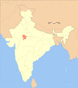
Betul district is a district of Madhya Pradesh state in central India. The city of Betul serves as its administrative headquarters. The district is a part of Narmadapuram Division.

<span class="mw-page-title-main">Sawai Madhopur district</span> District of Rajasthan in India

Sawai Madhopur district is a district of Rajasthan state in north-west India. Sawai Madhopur is the chief town and district headquarters. Sawai Madhopur district comes under Bharatpur division.

<span class="mw-page-title-main">Sheopur district</span> District of Madhya Pradesh in India

Sheopur District is a district of Madhya Pradesh state in central India. The district is located in the north of the state and forms part of Chambal division. It is situated on the periphery of Rajasthan, which shows in the influence of Rajasthani culture in this district.

<span class="mw-page-title-main">Panna district</span> District of Madhya Pradesh in India

Panna district is a district of the Sagar Division, within the Madhya Pradesh state in central India. The town of Panna is the district headquarters.

<span class="mw-page-title-main">Dindori district</span> District of Madhya Pradesh in India

Dindori District, formerly known as Ramgarh District, is a district of Madhya Pradesh state of central India. The town of Dindori is the district headquarters. The district is part of Jabalpur Division. Total area of the district is 6,128 km2 (2,366 sq mi). It is located on the eastern part of Madhya Pradesh, bordering the state of Chhattisgarh. It is surrounded by Anuppur district to the northeast, Umaria district to the north, Jabalpur district to the west, Mandla district to the southwest and Mungeli and Kabirdham districts of Chhattisgarh to the south.

<span class="mw-page-title-main">Katni district</span> District of Madhya Pradesh in India

Katni District, also known as Murwara District, is one of the 52 districts of Madhya Pradesh state in central India. The town of Katni (Murwara) is the District headquarters. The District is part of Jabalpur Division. The District occupies an area of 4949.59 km².

<span class="mw-page-title-main">Mandla district</span> District of Madhya Pradesh in India

Mandla District is a district of Madhya Pradesh in central India. The town of Mandla is the administrative headquarters of the district. It is part of Jabalpur Division.

<span class="mw-page-title-main">Guna district</span> District in Madhya Pradesh, India

Guna district is one of the 52 districts of Madhya Pradesh in central India. Its administrative headquarters is Guna. The district has a population of 1,241,519. It has an area of 6390 km², and is bounded on the northeast by Shivpuri District, on the east by Ashoknagar District, on the southeast by Vidisha District, on the southwest by Rajgarh District, on the west and northwest by Jhalawar and Baran districts of Rajasthan state. The Sindh River flows northward along the eastern edge of the district, forming part of the boundary with Ashoknagar District, and the Parvati River flows northwestward through the southern portion of the district, forming part of the boundary with Baran District before flowing into Rajasthan.

<span class="mw-page-title-main">Jhabua district</span> District of Madhya Pradesh in India

Jhabua is a district of Madhya Pradesh state in central India. The town of Jhabua is the administrative headquarters of the district.

<span class="mw-page-title-main">Barwani district</span> District of Madhya Pradesh in India

Barwani district is one of the districts of Madhya Pradesh state of India. The administrative headquarters of the district is at Barwani. Barwani district has an area of 5,427 km² and a population 1,385,881. The district lies in the southwestern corner of Madhya Pradesh; the Narmada River forms its northern boundary. The Satpura Range lies to its south. The district is bordered by Maharashtra state to the south, Gujarat state to the west, Dhar District to the north and Khargone District to the east.

<span class="mw-page-title-main">Ratlam district</span> District of Madhya Pradesh in India

Ratlam District is a district of Madhya Pradesh state in central India. The town of Ratlam is administrative headquarters of the district.

<span class="mw-page-title-main">Chittorgarh district</span> District of Rajasthan in India

Chittorgarh district is one of the 33 districts of Rajasthan state in western India. The historic city of Chittaurgarh is the administrative headquarters of the district. The district was established on 1 August 1948 by integrating portions of various princely states: Mewar, Pratabgarh, Tonk, and Jhalawar. Chittaurgarh is famous for the Chittor fort, home to various famous Rajput dynasties.

<span class="mw-page-title-main">Vidisha district</span> District of Madhya Pradesh in India

Vidisha District (विदिशा) is in Madhya Pradesh state, in central India. The city of Vidisha is the administrative headquarters of the district.

<span class="mw-page-title-main">Shivpuri district</span> District of Madhya Pradesh in India

Shivpuri District is a district of Madhya Pradesh state of India. The town of Shivpuri is the district headquarters. National Highway 3 (NH-3) runs through the district.

<span class="mw-page-title-main">Khandwa district</span> District of Madhya Pradesh in India

Khandwa district, formerly known as the East Nimar district, is a district of the Madhya Pradesh state in central India. The city of Khandwa is the administrative headquarters of the district. Other notable towns in the district include Mundi, Harsud, Pandhana and Omkareshwar.

<span class="mw-page-title-main">Banswara district</span> District of Rajasthan in India

Banswara District has an area of 5,037 km2 (1,945 sq mi), which is 1.47% of Rajasthan state, India. The city of Banswara is the district headquarters. It is bounded on the north by Udaipur District, on the northeast by Pratapgarh District, on the east and southeast by Madhya Pradesh state, on the southwest by Gujarat state, and on the west by Dungarpur District.

<span class="mw-page-title-main">Dungarpur district</span> District of Rajasthan in India

Dungarpur District is a district of the state of Rajasthan in western India. The town of Dungarpur is the district headquarters.

<span class="mw-page-title-main">Tonk district</span> District of Rajasthan in India

Tonk district is a district of the state of Rajasthan in western India. The city of Tonk is the administrative headquarters of the district. The district is bounded on the north by Jaipur district, on the east by Sawai Madhopur district, on the southeast by Kota district, on the south by Bundi district, on the southwest by Bhilwara district, and on the west by Ajmer district.

References

  1. 1 2 3 4 5 6 7 "District Census Handbook 2011 - Jhalawar" (PDF). Census of India . Registrar General and Census Commissioner of India.
  2. 1 2 Ministry of Panchayati Raj (8 September 2009). "A Note on the Backward Regions Grant Fund Programme" (PDF). National Institute of Rural Development. Archived from the original (PDF) on 5 April 2012. Retrieved 27 September 2011.
  3. "Blocks/Tehsils/Panchayats". jhalawar.rajasthan.gov.in. Govt of Rajasthan. Retrieved 16 June 2021.
  4. "Tehsils". jhalawar.rajasthan.gov.in. Retrieved 16 June 2021.
  5. Decadal Variation In Population Since 1901
  6. "Table C-01 Population By Religion - Rajasthan". census.gov.in. Registrar General and Census Commissioner of India.
  7. US Directorate of Intelligence. "Country Comparison:Population". Archived from the original on 13 June 2007. Retrieved 1 October 2011. Swaziland 1,370,424
  8. "2010 Resident Population Data". U. S. Census Bureau. Archived from the original on 19 October 2013. Retrieved 30 September 2011. Hawaii 1,360,301
  9. 1 2 "Table C-16 Population by Mother Tongue: Rajasthan". censusindia.gov.in. Registrar General and Census Commissioner of India.

24°36′N76°09′E / 24.600°N 76.150°E / 24.600; 76.150