Blandinsville, Illinois

Last updated

Blandinsville, Illinois
McDonough County Illinois Incorporated and Unincorporated areas Blandinsville Highlighted.svg
Location in McDonough County, Illinois
Usa edcp location map.svg
Red pog.svg
Blandinsville
Location in the United States
Coordinates: 40°33′17″N90°51′57″W / 40.55472°N 90.86583°W / 40.55472; -90.86583
CountryUnited States
StateIllinois
County McDonough
Townships Blandinsville, Hire
Area
[1]
  Total0.88 sq mi (2.27 km2)
  Land0.88 sq mi (2.27 km2)
  Water0.00 sq mi (0.00 km2)
Elevation
729 ft (222 m)
Population
 (2020) [2]
  Total569
  Density650.29/sq mi (251.03/km2)
Time zone UTC-6 (CST)
  Summer (DST) UTC-5 (CDT)
ZIP Code
61420
Area code 309
FIPS code 17-06470
Wikimedia CommonsBlandinsville, Illinois

Blandinsville is a village in McDonough County, Illinois, United States. The population was 569 at the 2020 census, [2] down from 651 in 2010.

Contents

History

The town is named for Joseph L. Blandin, owner of the first general store. In 1842, the town was platted on a tract known as Job's Settlement, named after early settlers William and Ira Job. A post office was established in 1843. [3] The Frank Hicks House in Blandinsville was constructed by architect George Franklin Barber in 1895.

Geography

Blandinsville is in northwestern McDonough County. Illinois Route 9 passes through the village as Washington Street, leading northwest 6 miles (10 km) to La Harpe and east 19 miles (31 km) to Bushnell. Macomb, the McDonough county seat, is 16 miles (26 km) to the southeast via IL-9 and U.S. Route 67.

According to the U.S. Census Bureau, Blandinsville has a total area of 0.88 square miles (2.28 km2), all land. [1] The village sits on a low ridge bordered by Little Creek to the north and Baptist Creek to the south. Both are west-flowing tributaries of La Harpe Creek, a tributary of the La Moine River and part of the Illinois River watershed.

Demographics

Historical population
CensusPop.Note
1860 455
1870 1,565244.0%
1890 877
1900 99513.5%
1910 987−0.8%
1920 1,0021.5%
1930 952−5.0%
1940 914−4.0%
1950 9180.4%
1960 853−7.1%
1970 9228.1%
1980 886−3.9%
1990 762−14.0%
2000 7772.0%
2010 651−16.2%
2020 569−12.6%
U.S. Decennial Census [4]

As of the census [5] of 2000, there were 777 people, 339 households, and 224 families residing in the village. The population density was 878.2 inhabitants per square mile (339.1/km2). There were 353 housing units at an average density of 399.0 per square mile (154.1/km2). The racial makeup of the village was 98.71% White, 0.13% Asian, 0.51% from other races, and 0.64% from two or more races. Hispanic or Latino of any race were 0.77% of the population.

There were 339 households, out of which 28.9% had children under the age of 18 living with them, 54.0% were married couples living together, 7.4% had a female householder with no husband present, and 33.9% were non-families. 29.8% of all households were made up of individuals, and 18.0% had someone living alone who was 65 years of age or older. The average household size was 2.29 and the average family size was 2.83.

In the village, the population was spread out, with 22.3% under the age of 18, 8.4% from 18 to 24, 26.5% from 25 to 44, 23.9% from 45 to 64, and 18.9% who were 65 years of age or older. The median age was 41 years. For every 100 females, there were 101.3 males. For every 100 females age 18 and over, there were 98.0 males.

The median income for a household in the village was $30,272, and the median income for a family was $39,028. Males had a median income of $30,625 versus $19,479 for females. The per capita income for the village was $15,203. About 6.8% of families and 8.8% of the population were below the poverty line, including 6.2% of those under age 18 and 7.2% of those age 65 or over.

Education

Blandinsville is part of the West Prairie Community Unit School District 103. Students attend elementary school at North Elementary located in Good Hope and Middle School in Colchester. Students then go on to attend West Prairie High School in Sciota.

Related Research Articles

<span class="mw-page-title-main">Hancock County, Illinois</span> County in Illinois, United States

Hancock County is a county in the U.S. state of Illinois. According to the 2020 census, it has a population of 17,620. Its county seat is Carthage, and its largest city is Hamilton. The county is composed of rural towns with many farmers.

<span class="mw-page-title-main">Plymouth, Illinois</span> Village in Illinois, United States

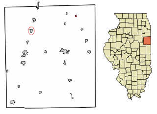
Plymouth is a village in Hancock and McDonough counties, Illinois, United States. The population was 436 at the 2020 census, down from 505 in 2010.

<span class="mw-page-title-main">Biggsville, Illinois</span> Village in Illinois, United States

Biggsville is a village in Henderson County, Illinois, United States. The population was 304 at the 2010 census, down from 343 at the 2000 census. It is part of the Burlington, IA–IL Micropolitan Statistical Area.

<span class="mw-page-title-main">Beaverville, Illinois</span> Village in Illinois, United States

Beaverville is a village in Beaverville Township, Iroquois County, Illinois, United States. The population was 362 at the 2010 census.

<span class="mw-page-title-main">Waltonville, Illinois</span> Village in Illinois, United States

Waltonville is a village in Jefferson County, Illinois, United States. The population was 434 at the 2010 census. It is part of the Mount Vernon Micropolitan Statistical Area.

<span class="mw-page-title-main">Bardolph, Illinois</span> Village in Illinois, United States

Bardolph is a village in McDonough County, Illinois, United States. The population was 210 at the 2020 census, down from 251 in 2010.

<span class="mw-page-title-main">Bushnell, Illinois</span> City in Illinois, United States

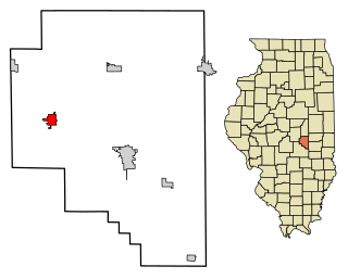
Bushnell is a city in McDonough County, Illinois, United States. The population was 2,718 at the 2020 census, down from 3,117 in 2010.

<span class="mw-page-title-main">Colchester, Illinois</span> City in Illinois, United States

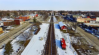
Colchester is a city in McDonough County, Illinois, United States. The population was 1,108 at the 2020 census, down from 1,401 in 2010. The city is named after the city of Colchester, England.

<span class="mw-page-title-main">Good Hope, Illinois</span> Village in Illinois, United States

Good Hope is a village in McDonough County, Illinois, United States. Its population was 363 at the 2020 census.

<span class="mw-page-title-main">Industry, Illinois</span> Village in Illinois, United States

Industry is a village in McDonough County, Illinois, United States. As of the 2020 census, the village population was 399, down from 478 in 2010.

<span class="mw-page-title-main">Prairie City, Illinois</span> Village in Illinois, United States

Prairie City is a village in McDonough County, Illinois, United States. The population was 407 at the 2020 census.

<span class="mw-page-title-main">Tennessee, Illinois</span> Village in Illinois, United States

Tennessee is a village in McDonough County, Illinois, United States. The population was 101 at the 2020 census.

<span class="mw-page-title-main">Prairie Grove, Illinois</span> Village in Illinois, United States

Prairie Grove is a village in McHenry County, Illinois, United States, first incorporated in 1973. Per the 2020 census, the population was 1,963.

<span class="mw-page-title-main">Hecker, Illinois</span> Village in Illinois, United States

Hecker is a village in Monroe County in the U.S state of Illinois. The population was 429 at the 2020 census, down from 481 in 2010.

<span class="mw-page-title-main">Raymond, Illinois</span> Village in Illinois, United States

Raymond is a village in Montgomery County, Illinois, United States. The population was 949 at the 2020 census.

<span class="mw-page-title-main">South Jacksonville, Illinois</span> Village in Illinois, United States

South Jacksonville is a village in Morgan County, Illinois, United States. The population was 3,302 at the 2020 census. It is part of the Jacksonville Micropolitan Statistical Area.

<span class="mw-page-title-main">Bethany, Illinois</span> Village in Illinois, United States

Bethany is a village in Moultrie County, Illinois, United States. The population was 1,255 at the 2020 census, down from 1,352 in 2010.

<span class="mw-page-title-main">Dupo, Illinois</span> Village in Illinois, United States

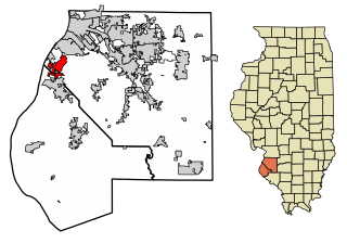
Dupo is a village in St. Clair County, Illinois, United States. The population was 4,138 at the 2010 census, an increase from 3,933 in 2000. The village was settled in about 1750 and was incorporated in 1907. Its modern name, adopted in the early 20th century, is shortened from Prairie du Pont.

<span class="mw-page-title-main">Burnt Prairie, Illinois</span> Village in Illinois, United States

Burnt Prairie is a village in White County, Illinois, United States. The population was 58 at the 2000 census.

<span class="mw-page-title-main">La Harpe, Kansas</span> City in Allen County, Kansas

La Harpe is a city in Allen County, Kansas, United States. As of the 2020 census, the population of the city was 480.

References

  1. 1 2 "2022 U.S. Gazetteer Files: Illinois". United States Census Bureau. Retrieved March 6, 2023.
  2. 1 2 "P1. Race – Blandinsville village, Illinois: 2020 DEC Redistricting Data (PL 94-171)". U.S. Census Bureau. Retrieved March 6, 2023.
  3. Callary, Edward (2009). Place Names of Illinois. University of Illinois. ISBN   9780252090707.
  4. "Census of Population and Housing". Census.gov. Retrieved June 4, 2015.
  5. "U.S. Census website". United States Census Bureau . Retrieved January 31, 2008.