Bogan Shire

Last updated

Bogan Shire
New South Wales
Bogan LGA NSW.png
Location in New South Wales
Coordinates 31°34′S147°12′E / 31.567°S 147.200°E / -31.567; 147.200 Coordinates: 31°34′S147°12′E / 31.567°S 147.200°E / -31.567; 147.200
Population
 • Density0.21/km2 (0.54/sq mi)
Established7 May 1906 (1906-05-07). [3]
Area14,611 km2 (5,641.3 sq mi)
MayorGlen Neill (Unaligned)
Council seat Nyngan [4]
Region Orana
State electorate(s) Barwon
Federal division(s) Parkes
Bogan Shire Council Logo.png
Website Bogan Shire
LGAs around Bogan Shire:
Bourke Brewarrina Warren
Cobar Bogan Shire Warren
Cobar Lachlan Lachlan

Bogan Shire is a local government area in the Orana region of New South Wales, Australia. The Shire is located adjacent to the Mitchell and Barrier highways and its only significant town is Nyngan. [5]

Contents

The Municipality of Nyngan was proclaimed on 17 February 1891 with Nyngan having a population of 1,355. Bogan Shire was proclaimed on 7 May 1906. [3] Bogan Shire absorbed the Municipality of Nyngan on 1 January 1972. [6]

The Mayor of Bogan Shire Council is Cr. Glen Neill, who is unaligned with any political party.

Demographics

Selected historical census data for Bogan Shire local government area
Census year2001 [7] 2006 [8] 2011 [9] 2016 [1]
PopulationEstimated residents on census night 3,083Decrease2.svg 2,883Increase2.svg 2,900Decrease2.svg 2,692
LGA rank in terms of size within New South Wales 122ndDecrease2.svg 125th
% of New South Wales population0.05%Decrease2.svg 0.04%Steady2.svg 0.04%Steady2.svg 0.04%
% of Australian population0.02%Decrease2.svg 0.01%Steady2.svg 0.01%Steady2.svg 0.01%
Cultural and language diversity
Ancestry,
top responses
Australian 39.3%Decrease2.svg 39.1%
English 30.6%Decrease2.svg 28.7%
Irish 10.3%Decrease2.svg 9.1%
Scottish 5.4%Increase2.svg 5.6%
German 1.9%Increase2.svg 2.1%
Language,
top responses
(other than English)
Afrikaans n/cSteady2.svg n/cSteady2.svg n/cIncrease2.svg 0.3%
Urdu n/cSteady2.svg n/cIncrease2.svg 0.2%Increase2.svg 0.3%
Filipino n/cSteady2.svg n/cSteady2.svg n/cIncrease2.svg 0.2%
Portuguese n/cIncrease2.svg 0.1%Decrease2.svg n/cIncrease2.svg 0.1%
Vietnamese n/cSteady2.svg n/cSteady2.svg n/cIncrease2.svg 0.1%
Religious affiliation
Religious affiliation,
top responses
Catholic 37.1%Increase2.svg 37.7%Decrease2.svg 36.6%Decrease2.svg 34.9%
Anglican 33.9%Decrease2.svg 32.6%Decrease2.svg 29.6%Decrease2.svg 25.3%
Not Statedn/cSteady2.svg n/cSteady2.svg n/cIncrease2.svg 12.1%
No Religion 4.4%Increase2.svg 6.8%Increase2.svg 7.4%Increase2.svg 11.5%
Uniting Church 11.9%Decrease2.svg 10.3%Decrease2.svg 9.6%Decrease2.svg 8.6%%
Median weekly incomes
Personal incomeMedian weekly personal incomeA$365A$478A$634
% of Australian median income78.3%Increase2.svg 82.8%Increase2.svg 95.8%
Family incomeMedian weekly family incomeA$944A$1,182A$1,561
% of Australian median income80.6%Decrease2.svg 79.8%Increase2.svg 90.0%
Household income Median weekly household incomeA$708A$902A$1,155
% of Australian median income68.9%Increase2.svg 73.1%Increase2.svg 80.3%

Incomes

According to the Australian Bureau of Statistics during 2003-04 there: [10]

Council

Current composition and election method

Bogan Shire Council is composed of nine Councillors elected proportionally as a single ward. All Councillors are elected for a fixed four-year term of office. The Mayor is elected by the Councillors at the first meeting of the Council. The most recent election was held on 4 December 2021, and the makeup of the Council is as follows: [11]

PartyCouncillors
  Independents and Unaligned9
Total9

The current Council, elected in 2021, in order of election, is: [11]

CouncillorPartyNotes
 Victoria Boag Independent Deputy Mayor [12]
 Graham JacksonUnaligned
 Glen NeillUnalignedMayor [12]
 Karl BrightIndependent
 Jodi DouglasIndependent
 Tony EliasUnaligned
 Greg DeaconUnaligned
 Richard MilliganUnaligned
 Douglas MenziesUnaligned

Meteorology

Bogan Shire is supported by agricultural production, grazing of sheep and cattle and cropping, primarily wheat. The area averages about 17 inches (430 mm) per year. However, there is great variability in the rainfall. In 1888 Nyngan had only 7.5 inches (190 mm) recorded, while in 1950 it had nearly 45 inches (1,100 mm).

Related Research Articles

<span class="mw-page-title-main">Nyngan</span> Town in New South Wales, Australia

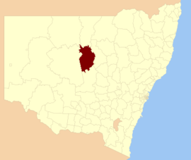
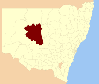
Nyngan is a town in the centre of New South Wales, Australia, in the Bogan Shire local government area within the Orana Region of central New South Wales. At the 2016 census, Nyngan had a population of 1,988 people. Nyngan is situated on the Bogan River between Narromine and Bourke, on the junction of the Mitchell Highway and Barrier Highway, 656 km (408 mi) south of Charleville and 576 km (358 mi) north-west of Sydney by road. The Barrier Highway starts at Nyngan, and runs west to Cobar and on through Wilcannia and Broken Hill into South Australia.

<span class="mw-page-title-main">Warrumbungle Shire</span> Local government area in New South Wales, Australia

The Warrumbungle Shire is a local government area in the central western region of New South Wales, Australia. The Shire is traversed by the Newell Highway. The Warrumbungle mountain range and Warrumbungles National Park are major tourist attractions for the Shire. Its capital is Coonabarabran, a city in the southwest.

<span class="mw-page-title-main">Narromine Shire</span> Local government area in New South Wales, Australia

Narromine Shire is a local government area in the Orana region of New South Wales, Australia. The Shire is located adjacent to the Mitchell Highway and the Main Western railway line. It was formed on 1 January 1981 from the amalgamation of the Municipality of Narromine and Timbrebongie Shire resulting from the Local Government Areas Amalgamation Act 1980.

<span class="mw-page-title-main">Weddin Shire</span> Local government area in New South Wales, Australia

Weddin Shire is a local government area in the Central West region of New South Wales, Australia. The shire's major town is Grenfell and it also includes the small towns of Caragabal, Greenethorpe and Quandialla.

<span class="mw-page-title-main">Central Darling Shire</span> Local government area in New South Wales, Australia

Central Darling Shire is a local government area in the Far West region of New South Wales, Australia. The Shire is located adjacent to the Barrier Highway. Central Darling Shire was constituted in 1959 and at 53,511 square kilometres (20,661 sq mi), it is the largest incorporated local government area in New South Wales.

<span class="mw-page-title-main">Berrigan Shire</span> Local government area in New South Wales, Australia

Berrigan Shire is a local government area in the southern Riverina region of New South Wales, Australia. The Shire lies on the New South Wales State border with Victoria formed by the Murray River. The Shire is adjacent to the Newell and Riverina Highways. The Shire is a mainly agricultural region, with dairying, cattle raising, woolgrowing and cropping the main activities. The vast majority of the Shire is irrigated. Tourism is another major activity, concentrated on the river towns of Tocumwal and Barooga.

<span class="mw-page-title-main">Ballina Shire</span> Local government area in New South Wales, Australia

Ballina Shire is a local government area in the Northern Rivers region of New South Wales, Australia. The Shire was formed on 1 January 1977 by the amalgamation of the Municipality of Ballina and Tintenbar Shire. The Shire is located adjacent to the Tasman Sea and the Pacific Highway. The council seat is located in the town of Ballina. The population of the Ballina Shire area was 44,208 in June 2018.

<span class="mw-page-title-main">Bellingen Shire</span> Local government area in New South Wales, Australia

Bellingen Shire is a local government area in the mid north coast region of New South Wales, Australia. The Shire is located adjacent to the Pacific Highway, Waterfall Way and the North Coast railway line.

<span class="mw-page-title-main">Parkes Shire</span> Local government area in New South Wales, Australia

Parkes Shire is a local government area in the Central West region of New South Wales, Australia. The Shire is located adjacent to the Broken Hill railway line and the Newell Highway.

<span class="mw-page-title-main">Walcha Shire</span> Local government area in New South Wales, Australia

Walcha Shire is a local government area located in the New England region of New South Wales, Australia. The Shire is situated adjacent to the junction of the Oxley Highway and Thunderbolts Way and is 20 kilometres (12 mi) east of the Main North railway line passing through Walcha Road. The shire was formed on 1 June 1955 through the amalgamation of Apsley Shire and the Municipality of Walcha.

<span class="mw-page-title-main">Uralla Shire</span> Local government area in New South Wales, Australia

Uralla Shire is a local government area located in the New England region of New South Wales, Australia. The New England Highway passes through the Shire.

<span class="mw-page-title-main">Lockhart Shire</span> Local government area in New South Wales, Australia

Lockhart Shire is a local government area in the Riverina region of New South Wales, Australia. The Shire was created in 1906 and is an agricultural and pastoral area.

<span class="mw-page-title-main">Hay Shire</span> Local government area in New South Wales, Australia

The Hay Shire is a local government area in the Riverina area of south-western New South Wales, Australia. The Shire comprises 11,326 square kilometres (4,373 sq mi) and is located adjacent to the Sturt, Mid-western and Cobb Highways. The area includes the towns of Hay, Booligal and Maude.

<span class="mw-page-title-main">Coonamble Shire</span> Local government area in New South Wales, Australia

Coonamble Shire is a local government area in the Orana region of New South Wales, Australia. The Shire is located adjacent to the Castlereagh Highway and the Castlereagh River.

<span class="mw-page-title-main">Walgett Shire</span> Local government area in New South Wales, Australia

Walgett Shire is a local government area in the Orana region of New South Wales, Australia. The northern boundary of the Shire is located adjacent to the border between New South Wales and Queensland. The town of Walgett is located on the Namoi River, nearby to its junction with the Barwon River and at the junction of the Kamilaroi Highway and the Castlereagh Highway.

<span class="mw-page-title-main">Warren Shire</span> Local government area in New South Wales, Australia

Warren Shire is a local government area in the Orana region of New South Wales, Australia. The Shire is located adjacent to the Macquarie River and the Mitchell and Oxley Highways. The use of the area is mainly for wool and cotton growing.

<span class="mw-page-title-main">Brewarrina Shire</span> Local government area in New South Wales, Australia

Brewarrina Shire is a local government area in the Orana region of New South Wales, Australia. The Shire is located adjacent to the Darling River, which is known as the Barwon River upstream from Bourke; and located adjacent to the Kamilaroi Highway. The northern boundary of the Shire is located adjacent to the border between New South Wales and Queensland. The Shire is a wool and cotton growing area.

<span class="mw-page-title-main">Bourke Shire</span> Local government area in New South Wales, Australia

Bourke Shire is a local government area in the Orana region of New South Wales, Australia. The Shire is located adjacent to the Darling River, which is known as the Barwon River upstream from Bourke; and located adjacent to the Mitchell Highway. The northern boundary of the Shire is located adjacent to the border between New South Wales and Queensland. The shire is a wool and beef producing area.

<span class="mw-page-title-main">Cobar Shire</span> Local government area in New South Wales, Australia

Cobar Shire is a local government area in the Orana region of New South Wales, Australia. The Shire is located in an outback area that is centred around the mining town of Cobar. The Shire is traversed by the Barrier Highway and the Kidman Way. With a total area of 44,065 square kilometres (17,014 sq mi), about two-thirds the size of Tasmania, Cobar Shire is larger than Denmark and 99 other countries and self-governing territories, but its population is under 5000.

<span class="mw-page-title-main">Murrumbidgee Council</span> Local government area in New South Wales, Australia

Murrumbidgee Council is a local government area in the Riverina region of New South Wales, Australia. This area was formed in 2016 from the merger of the Murrumbidgee Shire with the neighbouring Jerilderie Shire.

References

  1. 1 2 Australian Bureau of Statistics (27 June 2017). "Bogan (A)". 2016 Census QuickStats. Retrieved 27 August 2020. OOjs UI icon edit-ltr-progressive.svg
  2. "3218.0 – Regional Population Growth, Australia, 2017-18". Australian Bureau of Statistics. 27 March 2019. Retrieved 27 March 2019. Estimated resident population (ERP) at 30 June 2018.
  3. 1 2 "Proclamation (121)". Government Gazette of the State of New South Wales . 7 March 1906. p. 1593. Retrieved 22 October 2018 via National Library of Australia.
  4. "Bogan Shire Council". Division of Local Government . Retrieved 3 December 2006.
  5. "2016 Bogan (A), Census All persons QuickStats | Australian Bureau of Statistics". www.abs.gov.au. Retrieved 3 August 2022.
  6. "Local Government Act 1919. Proclamation (149)". Government Gazette of the State of New South Wales . 24 December 1971. p. 4955. Retrieved 22 October 2018 via National Library of Australia.
  7. Australian Bureau of Statistics (9 March 2006). "Bogan (A)". 2001 Census QuickStats. Retrieved 26 August 2020. OOjs UI icon edit-ltr-progressive.svg
  8. Australian Bureau of Statistics (25 October 2007). "Bogan (A)". 2006 Census QuickStats. Retrieved 26 August 2020.
  9. Australian Bureau of Statistics (31 October 2012). "Bogan (A)". 2011 Census QuickStats. Retrieved 26 August 2020. OOjs UI icon edit-ltr-progressive.svg
  10. "Regional Wage and Salary Earner Statistics, Australia (catalogue no.: 5673.055.003)". Australian Bureau of Statistics . Retrieved 11 March 2007.
  11. 1 2 "Bogan - Councillor Election results". NSW Electoral Commission. 21 December 2021. Retrieved 18 March 2022.
  12. 1 2 "NEW MAYOR AND DEPUTY MAYOR FOR BOGAN SHIRE - Bogan Shire Council". www.bogan.nsw.gov.au. Retrieved 18 March 2022.