Port Macquarie-Hastings Council

Last updated

Port Macquarie-Hastings
New South Wales
Hastings LGA NSW.png
Location in New South Wales
Coordinates 31°26′S152°54′E / 31.433°S 152.900°E / -31.433; 152.900
Population
 • Density23.5376/km2 (60.9621/sq mi)
Established
  • 1 January 1981
    (Municipality of Hastings)
  • 13 July 2005
    (Port Macquarie-Hastings Council)
Area3,686.1 km2 (1,423.2 sq mi)
MayorPeta Pinson (National) [3]
Council seat Port Macquarie
Region Mid North Coast
State electorate(s)
Federal division(s)
Port Macquarie-Hastings logo.png
Website Port Macquarie-Hastings
LGAs around Port Macquarie-Hastings:
Walcha Kempsey Tasman Sea
Walcha Port Macquarie-Hastings Tasman Sea
Mid-Coast Mid-Coast Tasman Sea

Port Macquarie-Hastings Council is a local government area in the Mid North Coast region of New South Wales, Australia.

Contents

The area is located adjacent to the Hastings River, the Pacific Highway, the Oxley Highway and the North Coast railway line. Major population centres in the local government area are Port Macquarie, Camden Haven, Wauchope, Lake Cathie and Kendall.

The mayor of the Port Macquarie-Hastings Council since 4 August 2017 is Cr. Peta Pinson, an independent politician who joined the Nationals in 2023.

Port Macquarie suburbs

Towns and localities

Towns and localities (including Port Macquarie suburbs) in the Port Macquarie-Hastings Council are: [4]

Demographics

At the 2021 Census, there were 86,762 people in the Port Macquarie-Hastings local government area, of these 47.9% were male and 52.1% were female. Aboriginal and Torres Strait Islander people made up 5.5% of the population, significantly higher than the national average. The median age of people in the Port Macquarie-Hastings Council area was 49 years; eleven years higher than the national median. Children aged 0 – 14 years made up 15.9% of the population and people aged 65 years and over made up 29.1% of the population. Of people in the area aged 15 years and over, 47.9% were married and 15.4% were either divorced or separated. [1]

Population growth in the Port Macquarie-Hastings Council area between the 2001 Census and the 2006 Census was 6.68%; and in the subsequent five years to the 2011 Census was 6.23%. When compared with total population growth of Australia for the same periods, being 5.78% and 8.32% respectively, population growth in the Port Macquarie-Hastings local government area was generally on par with the national average. [5] The median weekly income for residents within the Port Macquarie-Hastings Council area was slightly below the national average. [6] [7]

At the 2011 Census, the proportion of residents in the Port Macquarie-Hastings local government area who stated their ancestry as Australian or Anglo-Celtic exceeded 83% of all residents (national average was 65.2%). In excess of 64% of all residents in the Port Macquarie-Hastings Council area nominated a religious affiliation with Christianity at the 2011 Census, which was higher than the national average of 50.2%. Meanwhile, as at the Census date, compared to the national average, households in the Port Macquarie-Hastings local government area had a significantly lower than average proportion (3.6%) where two or more languages are spoken (national average was 20.4%); and a significantly higher proportion (93.7%) where English only was spoken at home (national average was 76.8%). [6]

Selected historical census data for Port Macquarie-Hastings local government area
Census year2001 [5] 2006 [7] 2011 [6] 2016 [8]
PopulationEstimated residents on census night 64,14668,43072,69678,539
LGA rank in terms of size within New South Wales 29thIncrease2.svg 28th
% of New South Wales population1.05%Steady2.svg 1.05%
% of Australian population0.34%Steady2.svg 0.34%Steady2.svg 0.34%Steady2.svg 0.34%
Cultural and language diversity
Ancestry,
top responses
English33.4%Decrease2.svg 32.9%
Australian32.8%Decrease2.svg 31.6%
Irish9.5%Increase2.svg 9.6%
Scottish7.7%Increase2.svg 7.9%
German2.8%Increase2.svg 2.9%
Language,
top responses
(other than English)
German0.3%Steady2.svg 0.3%Steady2.svg 0.3%Decrease2.svg 0.2%
Spanishn/cn/cIncrease2.svg 0.1%Increase2.svg 0.2%
French0.1%Steady2.svg 0.1%Steady2.svg 0.1%Increase2.svg 0.2%
Mandarinn/cSteady2.svg n/cSteady2.svg n/cIncrease2.svg 0.2%
Italian0.2%Steady2.svg 0.2%Steady2.svg 0.2%Steady2.svg 0.2%
Religious affiliation
Religious affiliation,
top responses
No religion 11.5%Increase2.svg 14.5%Increase2.svg 18.1%Increase2.svg 25.6%
Anglican 33.1%Decrease2.svg 31.3%Decrease2.svg 29.4%Decrease2.svg 24.6%
Catholic 24.2%Steady2.svg 24.2%Increase2.svg 24.7%Decrease2.svg 23.1%
Not statedn/cSteady2.svg n/cSteady2.svg n/cIncrease2.svg 8.8%
Uniting Church 8.4%Decrease2.svg 7.2%Decrease2.svg 6.0%Decrease2.svg 4.8%
Median weekly incomes
Personal incomeMedian weekly personal incomeA$361A$447A$540
% of Australian median income77.5%77.5%81.6%
Family incomeMedian weekly family incomeA$679A$1,008A$1,300
% of Australian median income66.1%68.1%75.0%
Household incomeMedian weekly household incomeA$891A$837A$1,042
% of Australian median income76.1%67.8%72.5%

Council

Current composition and election methods

Port Macquarie-Hastings Council is composed of nine councillors, including the mayor, for a fixed four-year term of office. The mayor is directly elected while the eight other councillors are elected proportionally as one entire ward. The most recent election was held on 10 September 2016, and the makeup of the council is as follows: [9] [10]

On 8 May 2017, the elected mayor since 2012, Peter Besseling, resigned effective immediately to take up an executive business position. Deputy Mayor Lisa Intemann served as acting mayor until a by-election was held for the mayoral position on 29 July 2017. [11] [12] On 4 August 2017, the final results were declared and Peta Pinson became mayor. [13] [14]

PartyCouncillors
  Team Pinson 5
 Fighters For Our Region1
 Hastings First1
  The Greens 1
 The Sheppard Team for Sensible, Sustainable Progress1
Total9 (including mayor)

The current council, elected in 2021, is: [15] [16]

CouncillorPartyNotes
 Peta PinsonTeam PinsonMayor
 Adam RobertsTeam Pinson
 Danielle MaltmanTeam Pinson
 Josh SladeTeam Pinson
 Sharon GriffithsTeam Pinson
 Lauren Edwards The Greens
 Lisa IntemannFighters For Our RegionElected 2012, 1995–2008, Acting Mayor May–August 2017
 Nik LipovacHastings First
 Rachel SheppardThe Sheppard Team for Sensible, Sustainable Progress

Election results

2021

Elected councillorParty
 Peta PinsonTeam Pinson
 Adam RobertsTeam Pinson
 Danielle MaltmanTeam Pinson
 Josh SladeTeam Pinson
 Sharon GriffithsTeam Pinson
 Lisa IntemannFighters
 Rachel SheppardSheppard Team
 Lauren EdwardsGreens
 Nik LipovacHastings First
2021 New South Wales local elections: Port Macquarie-Hastings [17]
PartyCandidateVotes%±%
Team Pinson24,57146.8
Fighters For Our Region9,07717.3
The Sheppard Team for Sensible, Sustainable Progress8,04615.3
Greens 4,7049.0
Hastings First4,3988.4
Independent Jon Bailey1,7213.3
Total formal votes52,51792.3
Informal votes4,4027.7
Turnout 56,91985.6

History

Local government in the Hastings region started with the passage of the District Councils Act 1842, which allowed for limited local government in the form of a warden and between 3 and 12 councillors to be appointed by the Governor. Between July and September 1843, 28 such entities had been proclaimed by Governor George Gipps. The Macquarie District Council, the 8th to be declared, was proclaimed on 12 August 1843, with a population of 2,409 and an area of 10,174 square kilometres (3,928 sq mi). [18] :208–209 Due to various factors, the district councils were ineffective, and most had ceased to operate by the end of the decade. [19]

After the enactment of the Municipalities Act of 1858, [20] which gave the councils more authority and which allowed for residents to petition for incorporation of areas and also to elect councillors, the town of Port Macquarie, population 984, petitioned to be incorporated as a municipality twice: in 1859 and again in 1867; but on both occasions, counter-petitions from other residents prevented it from being incorporated. [18] :274 Finally, on 15 March 1887, the Port Macquarie Municipal District was proclaimed, with the first elections on 25 May 1887 electing James McInherney as the first mayor. [21]

The Local Government (Shires) Act 1905 enabled the Shire of Hastings, based in the town of Wauchope, to come into being in June 1906, in time for elections in November 1906. The first Shire President was James O'Neill. [21]

In 1981, the two councils were amalgamated to form the Municipality of Hastings, with Norm Matesich becoming the council's inaugural mayor. In 1991, the council moved into its present premises in Burrawan Street, Port Macquarie. With the enactment of the Local Government Act 1993 (NSW), which changed the responsibilities of the mayor and councillors, the Hastings Council was created. In 2005, the name was changed to Port Macquarie-Hastings following a community survey, showing that many people thought that the new name would better reflect the area. [21]

Glasshouse controversy

On 27 February 2008 the Minister for Local Government, Paul Lynch, dismissed the council and appointed an administrator, Dick Persson, who also administered the Northern Beaches Council and Warringah Council in Sydney, and the Central Coast Council in the Central Coast region. The dismissal of council was made after alleged mishandling of a project initiated in 2001 to build a cultural and entertainment centre, known to locals as the Glasshouse. [22] The project, initially a joint venture with the management of the neighbouring shopping centre, Port Central, was initially expected to cost the Council A$7.3 million, but by late 2007, despite the centre not yet having opened, the costs had blown out to over A$41.7 million, with interest repayments likely to extend the council's liability to A$66 million. On 27 July 2007, a full public inquiry was announced by the Minister for Local Government, which reported back in February 2008. [23]

The inquiry report found that the council had failed to provide appropriate financial and project management and had lost control of the costs, that the project costs had harmed the council's ability to provide services and amenities to the community, and that the council's "communications management strategies" had resulted in inadequate consultation with the public or appropriate regard to their concerns. The outgoing mayor, Rob Drew, was critical of the process throughout, maintaining that errors had been made and misinformation had been accepted as fact; however, the New South Wales Urban Task Force, a property development lobby group, believed the dismissal served as a warning to other councils to stick to "core responsibilities". In 2009 it was revealed that the Glasshouse would cost ratepayers around A$6 million a year to run. [24]

See also

Related Research Articles

<span class="mw-page-title-main">City of Lake Macquarie</span> Local government area in New South Wales, Australia

The City of Lake Macquarie is a local government area in the Hunter Region in New South Wales, Australia. It was proclaimed a city from 7 September 1984. The city is situated adjacent to the city of Newcastle and is widely considered as a part of the Greater Newcastle area. The city is approximately 150 km (93 mi) north of Sydney. One of its major tourist attractions is its lake, also named Lake Macquarie.

<span class="mw-page-title-main">Pittwater Council</span> Former local government area in New South Wales, Australia

Pittwater Council was a local government area on the Northern Beaches of Sydney, in the state of New South Wales, Australia. It covered a region adjacent to the Tasman Sea about 30 kilometres (19 mi) north of the Sydney central business district. The area is named after Pittwater, the body of water adjacent to much of the area governed. First proclaimed in 1906 as the A Riding of Warringah Shire, the area was proclaimed as the Municipality of Pittwater on 1 May 1992. On 12 May 2016, the Minister for Local Government announced that Pittwater Council would be subsumed into the newly formed Northern Beaches Council. The last mayor of Pittwater Council was Councillor Jacqui Townsend, an independent politician.

<span class="mw-page-title-main">Huon Valley Council</span> Local government area in Tasmania, Australia

Huon Valley Council is a local government body in Tasmania, covering most of the south of the state. Huon Valley is classified as a rural local government area and has a population of 17,219, towns and localities of the region include Cygnet, Dover, Franklin, Geeveston, Southport and the largest principal town, Huonville.

<span class="mw-page-title-main">Clarence Valley Council</span> Local government area in New South Wales, Australia

Clarence Valley Council is a local government area in the Northern Rivers region of New South Wales, Australia.

<span class="mw-page-title-main">City of Hawkesbury</span> Local government area in New South Wales, Australia

The City of Hawkesbury is a local government area of New South Wales, Australia, the City of Hawkesbury is located on the North and North Western edge of the Greater Sydney area and is adjacent to the Sydney metropolitan area, about 50 kilometres (31 mi) north-west of the Sydney central business district. Hawkesbury City is named after the Hawkesbury River.

<span class="mw-page-title-main">Wauchope, New South Wales</span> Town in New South Wales, Australia

Wauchope ( ) is a town in the Mid North Coast region of New South Wales, Australia. It is within the boundaries of the Port Macquarie-Hastings Council area. Wauchope is inland on the Hastings River and the Oxley Highway 19 km (12 mi) west of Port Macquarie. The town is 383 km (238 mi) north of the state capital Sydney.

<span class="mw-page-title-main">City of Liverpool (New South Wales)</span> Local government area in New South Wales, Australia

The City of Liverpool is a local government area, administered by Liverpool City Council, located in the south-west of Sydney, in the state of New South Wales, Australia. The area encompasses 305.5 square kilometres (118.0 sq mi) and its administrative centre is located in the suburb of Liverpool.

<span class="mw-page-title-main">Tweed Shire</span> Local government area in New South Wales, Australia

Tweed Shire is a local government area located in the Northern Rivers region of New South Wales, Australia. It is adjacent to the border with Queensland, where that meets the Coral Sea. Administered from the town of Murwillumbah, Tweed Shire covers an area of 1,321 square kilometres (510 sq mi), and has existed as a local government entity since 1947. It was named for the Tweed River.

<span class="mw-page-title-main">City of Wollongong</span> Local government area in New South Wales, Australia

The City of Wollongong is a local government area in the Illawarra region of New South Wales, Australia. The area is situated adjacent to the Tasman Sea, the Princes Motorway and the Illawarra railway line.

<span class="mw-page-title-main">Port Stephens Council</span> Local government area in New South Wales, Australia

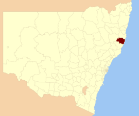
Port Stephens Council is a local government area in the Hunter Region of New South Wales, Australia. The area is just north of Newcastle and is adjacent to the Pacific Highway which runs through Raymond Terrace, the largest town and Council seat. The area is named after Port Stephens, which is the major geographical feature of the area. It extends generally from the Hunter River in the south, to near Clarence Town in the north, and from the Tasman Sea in the east, to just south of Paterson in the west. The mayor of Port Stephens Council is Ryan Palmer. Palmer was caught in a major scandal in 2022 following the purchase of an $86,000 Ford Ranger for mayoral and personal use. Port Stephens is about two and a half hours north of Sydney.

<span class="mw-page-title-main">Ballina Shire</span> Local government area in New South Wales, Australia

Ballina Shire is a local government area in the Northern Rivers region of New South Wales, Australia. The Shire was formed on 1 January 1977 by the amalgamation of the Municipality of Ballina and Tintenbar Shire. The Shire is located adjacent to the Tasman Sea and the Pacific Highway. The council seat is located in the town of Ballina. The population of the Ballina Shire area was 46,850 in 2022.

<span class="mw-page-title-main">City of Newcastle</span> Local government area in New South Wales, Australia

The City of Newcastle is a local government area in the Hunter region of New South Wales, Australia. The City of Newcastle incorporates much of the area of the Newcastle metropolitan area.

<span class="mw-page-title-main">City of Albury</span> Local government area in New South Wales, Australia

The City of Albury is a local government area in the Murray region of New South Wales, Australia. The area covers 305.9 square kilometres (118.1 sq mi) to the north of the Murray River. The area extends around 10 to 12 kilometres east and west along the river from the centre of Albury and up to 20 kilometres (12 mi) north. The population of the City of Albury area was 53,767 in June 2018.

<span class="mw-page-title-main">Bellingen Shire</span> Local government area in New South Wales, Australia

Bellingen Shire is a local government area in the Mid North Coast region of New South Wales, Australia. The shire is located adjacent to the Pacific Highway, Waterfall Way and the North Coast railway line.

<span class="mw-page-title-main">City of Lismore</span> Local government area in New South Wales, Australia

The City of Lismore is a local government area in the Northern Rivers region of New South Wales, Australia. The seat of the local government area is Lismore, a major regional centre of the state.

<span class="mw-page-title-main">Dungog Shire</span> Local government area in New South Wales, Australia

Dungog Shire is a local government area in the Hunter region of New South Wales, Australia. The Shire is situated adjacent to the Barrington Tops and consists predominantly of very rugged to hilly country which becomes less rugged from north to south.

<span class="mw-page-title-main">Warren Shire</span> Local government area in New South Wales, Australia

Warren Shire is a local government area in the Orana region of New South Wales, Australia. The Shire is located adjacent to the Macquarie River and the Mitchell and Oxley Highways. The use of the area is mainly for wool and cotton growing.

<span class="mw-page-title-main">Long Flat, New South Wales</span> Town in New South Wales, Australia

Long Flat is a rural village situated on the Oxley Highway and the southern bank of the Hastings River. This village is about 50 kilometres west of Port Macquarie, 30 kilometres west of Wauchope and 133 km east of Walcha. The boundaries are within the Port Macquarie-Hastings Council Local Government Area and Macquarie County.

<span class="mw-page-title-main">2024 New South Wales local elections</span>

The 2024 New South Wales local elections are scheduled to be held on 14 September 2024 to elect the councils of the 126 local government areas (LGAs) in New South Wales. Several councils will also hold mayoral elections.

References

  1. 1 2 Australian Bureau of Statistics (28 June 2022). "Port Macquarie-Hastings". 2021 Census QuickStats. Retrieved 11 December 2023. OOjs UI icon edit-ltr-progressive.svg
  2. "Regional population". Australian Bureau of Statistics. 20 April 2023. Retrieved 11 December 2023.
  3. "PETA PINSON FOR PORT MACQUARIE - NSW Nationals" . Retrieved 14 March 2023.
  4. "Port Macquarie-Hastings Council area". Archived from the original on 9 December 2017. Retrieved 28 February 2019.
  5. 1 2 Australian Bureau of Statistics (9 March 2006). "Hastings (A)". 2001 Census QuickStats. Retrieved 30 November 2012. OOjs UI icon edit-ltr-progressive.svg
  6. 1 2 3 Australian Bureau of Statistics (31 October 2012). "Port Macquarie-Hastings (A)". 2011 Census QuickStats. Retrieved 30 November 2012. OOjs UI icon edit-ltr-progressive.svg
  7. 1 2 Australian Bureau of Statistics (25 October 2007). "Hastings (A)". 2006 Census QuickStats. Retrieved 30 November 2012.
  8. Australian Bureau of Statistics (27 June 2017). "Port Macquarie-Hastings (A)". 2016 Census QuickStats. Retrieved 7 July 2017. OOjs UI icon edit-ltr-progressive.svg
  9. "Port Macquarie-Hastings Council – Mayoral Election". Local Government Election 2016. Electoral Commission of New South Wales. 20 September 2016. Archived from the original on 1 March 2017. Retrieved 20 September 2016.
  10. "Port Macquarie-Hastings Council – Summary of First Preference Votes for each Candidate". Local Government Election 2012. Electoral Commission of New South Wales. 16 September 2012. Archived from the original on 1 March 2017. Retrieved 29 September 2012.
  11. Daniels, Peter (8 May 2017). "Peter Besseling resigns as mayor | video". Port Macquarie News. Archived from the original on 7 August 2017. Retrieved 9 May 2017.
  12. "Mayoral by-election set for Saturday 29 July" (Press release). Port Macquarie-Hastings Council. 17 May 2017. Archived from the original on 7 August 2017. Retrieved 17 May 2017.
  13. Daniels, Peter (4 August 2017). "It's official: Peta Pinson declared our new mayor". Port Macquarie News. Archived from the original on 7 August 2017. Retrieved 4 August 2017.
  14. Tisdell, Lisa (2 August 2017). "Mayoral by-election 2017: Peta Pinson is mayor-elect". Port Macquarie News. Archived from the original on 5 August 2017. Retrieved 4 August 2017.
  15. "Port Macquarie-Hastings". ABC News.
  16. "Local Government Register of Groups of Candidates" (PDF).
  17. "Port Macquarie-Hastings". ABC News.
  18. 1 2 Larcombe, F. A. (Frederick) (1973). The Origin of Local Government in New South Wales 1831–58. Sydney University Press. ISBN   978-0-424-06610-3. See also Historical Records of Australia , Series I, volume xvii, Introduction, p.12.
  19. Merivale, Herman (1928) [1861]. Lectures on Colonization and the Colonies. Oxford University Press. pp. 651–653.
  20. 22 Vic No. 13 (Imp), assented 27 October 1858
  21. 1 2 3 "History of the Council". Port Macquarie-Hastings Council. 28 February 2008. Archived from the original on 22 July 2008. Retrieved 26 March 2008.
  22. "Council sacked over cost blow-out". Australia: ABC News. 27 February 2008. Archived from the original on 1 March 2008. Retrieved 27 February 2008.
  23. Willan, Frank. Port Macquarie-Hastings Council – Public Inquiry – Inquiry Report Volume 1. Government of New South Wales. ISBN   978-1-920766-69-6.
  24. "Task force says council sacking a warning to others". Australia: ABC News. 6 March 2008. Retrieved 12 April 2008.