Bogard, Missouri

Last updated

Bogard, Missouri
Carroll County Missouri Incorporated and Unincorporated areas Bogard Highlighted.svg
Location of Bogard, Missouri
Coordinates: 39°27′29″N93°31′26″W / 39.45806°N 93.52389°W / 39.45806; -93.52389
Country United States
State Missouri
County Carroll
Area
[1]
  Total0.55 sq mi (1.41 km2)
  Land0.55 sq mi (1.41 km2)
  Water0.00 sq mi (0.00 km2)
Elevation
[2]
866 ft (264 m)
Population
 (2020)
  Total167
  Density305.86/sq mi (118.17/km2)
Time zone UTC-6 (Central (CST))
  Summer (DST) UTC-5 (CDT)
ZIP code
64622
Area code 660
FIPS code 29-06832 [3]
GNIS feature ID2394213 [2]

Bogard is a city in Carroll County, Missouri, United States. The population was 167 at the 2020 census. [4]

Contents

History

Bogard was originally known as Bogard's Mound, after a tumulus near the site which a pioneer citizen named Bogard used as an observation tower. [5] The village plat was made in 1884. [6] A post office called Bogard Mound was established in 1872, and the name was changed to Bogard in 1884. [7]

Geography

According to the United States Census Bureau, the city has a total area of 0.55 square miles (1.42 km2), all land. [8]

Demographics

Historical population
CensusPop.Note
1890 300
1900 276−8.0%
1910 31614.5%
1920 38120.6%
1930 329−13.6%
1940 3341.5%
1950 285−14.7%
1960 277−2.8%
1970 2946.1%
1980 285−3.1%
1990 228−20.0%
2000 2342.6%
2010 164−29.9%
2020 1671.8%
U.S. Decennial Census [9]

2010 census

As of the census [10] of 2010, there were 164 people, 74 households, and 48 families living in the city. The population density was 298.2 inhabitants per square mile (115.1/km2). There were 94 housing units at an average density of 170.9 per square mile (66.0/km2). The racial makeup of the city was 100.0% White. Hispanic or Latino of any race were 3.7% of the population.

There were 74 households, of which 24.3% had children under the age of 18 living with them, 56.8% were married couples living together, 5.4% had a female householder with no husband present, 2.7% had a male householder with no wife present, and 35.1% were non-families. 28.4% of all households were made up of individuals, and 18.9% had someone living alone who was 65 years of age or older. The average household size was 2.22 and the average family size was 2.67.

The median age in the city was 45.5 years. 18.9% of residents were under the age of 18; 3.6% were between the ages of 18 and 24; 26.8% were from 25 to 44; 27.4% were from 45 to 64; and 23.2% were 65 years of age or older. The gender makeup of the city was 47.0% male and 53.0% female.

2000 census

As of the census [3] of 2000, there were 234 people, 98 households, and 68 families living in the city. The population density was 429.0 inhabitants per square mile (165.6/km2). There were 116 housing units at an average density of 212.6 per square mile (82.1/km2). The racial makeup of the city was 100.00% White. Hispanic or Latino of any race were 0.43% of the population.

There were 98 households, out of which 25.5% had children under the age of 18 living with them, 63.3% were married couples living together, 5.1% had a female householder with no husband present, and 30.6% were non-families. 27.6% of all households were made up of individuals, and 20.4% had someone living alone who was 65 years of age or older. The average household size was 2.39 and the average family size was 2.93.

In the city the population was spread out, with 24.8% under the age of 18, 4.7% from 18 to 24, 22.2% from 25 to 44, 27.4% from 45 to 64, and 20.9% who were 65 years of age or older. The median age was 41 years. For every 100 females, there were 107.1 males. For every 100 females age 18 and over, there were 97.8 males.

The median income for a household in the city was $22,639, and the median income for a family was $42,679. Males had a median income of $26,667 versus $16,458 for females. The per capita income for the city was $17,208. About 6.8% of families and 13.1% of the population were below the poverty line, including 22.9% of those under the age of eighteen and 12.7% of those 65 or over.

Related Research Articles

<span class="mw-page-title-main">Berger, Missouri</span> City in Missouri, United States

Berger is a city in northwest Franklin County, Missouri, United States, located south of the Missouri River. The population was 256 at the 2020 census.

<span class="mw-page-title-main">Linneus, Missouri</span> City in Missouri, United States

Linneus is a small city in Linn County, Missouri, United States. The population was 281 at the 2020 census. It is the county seat of Linn County.

<span class="mw-page-title-main">Tallapoosa, Missouri</span> City in Missouri, United States

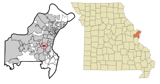
Tallapoosa is a city in New Madrid County, Missouri, United States. The population was 78 at the 2020 census.

<span class="mw-page-title-main">Hayti Heights, Missouri</span> City in Missouri, United States

Hayti Heights is a city in eastern Pemiscot County in the bootheel of southeast Missouri, United States. The population was 515 at the 2020 census.

<span class="mw-page-title-main">Crystal Lakes, Missouri</span> City in Missouri, United States

Crystal Lakes is a city in western Ray County, Missouri, and part of the Kansas City metropolitan area within the United States. The population was 390 at the 2020 census.

<span class="mw-page-title-main">Bella Villa, Missouri</span> City in Missouri, United States

Bella Villa is a city in St. Louis County, Missouri, in the United States. As of the 2010 census, the city population was 729.

<span class="mw-page-title-main">Country Club Hills, Missouri</span> City in Missouri, United States

Country Club Hills is a city in St. Louis County, Missouri, United States. The population was 1,274 at the 2010 census.

<span class="mw-page-title-main">Crystal Lake Park, Missouri</span> City in Missouri, United States

Crystal Lake Park is a Missouri Class 4 city in St. Louis County, Missouri, United States. The population was 508 at the 2020 census.

<span class="mw-page-title-main">Flordell Hills, Missouri</span> City in Missouri, United States

Flordell Hills is a city in St. Louis County, Missouri, United States. The population was 822 at the 2010 census.

<span class="mw-page-title-main">Green Park, Missouri</span> City in Missouri, United States

Green Park is a city in St. Louis County, Missouri, United States. The population was 2,622 at the 2010 census.

<span class="mw-page-title-main">Greendale, Missouri</span> City in Missouri, United States

Greendale is a city in St. Louis County, Missouri, United States. The population was 651 at the 2010 census.

<span class="mw-page-title-main">Lakeshire, Missouri</span> City in Missouri, United States

Lakeshire is a city in St. Louis County, Missouri, United States. The population was 1,432 at the 2010 census.

<span class="mw-page-title-main">Northwoods, Missouri</span> City in Missouri, United States

Northwoods is a city in St. Louis County, Missouri, United States. The population was 4,227 at the 2010 census.

<span class="mw-page-title-main">Oakland, Missouri</span> City in Missouri, United States

Oakland is a city in St. Louis County, Missouri, United States. The population was 1,381 at the 2010 census.

<span class="mw-page-title-main">Pasadena Hills, Missouri</span> City in Missouri, United States

Pasadena Hills is a city in St. Louis County, Missouri, United States. The population was 930 at the 2010 census. The entire city is listed on the National Register of Historic Places.

<span class="mw-page-title-main">Velda City, Missouri</span> City in Missouri, United States

Velda City is a city in St. Louis County, Missouri, United States. The population was 1,420 at the 2010 census.

<span class="mw-page-title-main">Winchester, Missouri</span> City in Missouri, United States

Winchester is a city in St. Louis County, Missouri, United States. The population was 1,447 at the 2020 census.

<span class="mw-page-title-main">Dudley, Missouri</span> City in Missouri, United States

Dudley is a city in Stoddard County, Missouri, United States. The population was 232 at the 2010 census.

<span class="mw-page-title-main">Clarkson Valley, Missouri</span> City in Missouri, United States

Clarkson Valley is a city in St. Louis County, Missouri, United States. The population was 2,609 at the 2020 census.

<span class="mw-page-title-main">Warson Woods, Missouri</span> City in Missouri, United States

Warson Woods is a city in St. Louis County, Missouri, United States. The population was 1,962 at the 2010 census.

References

  1. "ArcGIS REST Services Directory". United States Census Bureau. Retrieved August 28, 2022.
  2. 1 2 U.S. Geological Survey Geographic Names Information System: Bogard, Missouri
  3. 1 2 "U.S. Census website". United States Census Bureau . Retrieved January 31, 2008.
  4. "Explore Census Data". data.census.gov. Retrieved December 23, 2021.
  5. Eaton, David Wolfe (1916). How Missouri Counties, Towns and Streams Were Named. The State Historical Society of Missouri. pp.  271.
  6. "Carroll County Place Names, 1928–1945 (archived)". The State Historical Society of Missouri. Archived from the original on June 24, 2016. Retrieved September 10, 2016.{{cite web}}: CS1 maint: bot: original URL status unknown (link)
  7. "Post Offices". Jim Forte Postal History. Archived from the original on March 6, 2016. Retrieved September 10, 2016.
  8. "US Gazetteer files 2010". United States Census Bureau. Archived from the original on January 25, 2012. Retrieved July 8, 2012.
  9. "Census of Population and Housing". Census.gov. Retrieved June 4, 2015.
  10. "U.S. Census website". United States Census Bureau . Retrieved July 8, 2012.