Bosworth, Missouri

Last updated

Bosworth, Missouri
Bosworth, Missouri on February 21, 2019.jpg
Downtown in winter 2019
Carroll County Missouri Incorporated and Unincorporated areas Bosworth Highlighted.svg
Location of Bosworth, Missouri
Coordinates: 39°28′12″N93°20′08″W / 39.47000°N 93.33556°W / 39.47000; -93.33556
Country United States
State Missouri
County Carroll
Area
[1]
  Total0.55 sq mi (1.43 km2)
  Land0.55 sq mi (1.43 km2)
  Water0.00 sq mi (0.00 km2)
Elevation
[2]
764 ft (233 m)
Population
 (2020)
  Total213
  Density384.48/sq mi (148.54/km2)
Time zone UTC-6 (Central (CST))
  Summer (DST) UTC-5 (CDT)
ZIP code
64623
Area code 660
FIPS code 29-07426 [3]
GNIS feature ID2394224 [2]

Bosworth is a city in Carroll County, Missouri, United States. The population was 213 at the 2020 U.S. Census. [4]

Contents

History

Bosworth was laid out in 1888, and named for a settler. [5] A post office called Bosworth has been in operation since 1888. [6]

Geography

According to the United States Census Bureau, the city has a total area of 0.55 square miles (1.42 km2), all land. [7]

Demographics

Historical population
CensusPop.Note
1900 401
1910 76791.3%
1920 672−12.4%
1930 612−8.9%
1940 505−17.5%
1950 503−0.4%
1960 465−7.6%
1970 386−17.0%
1980 3942.1%
1990 334−15.2%
2000 38214.4%
2010 305−20.2%
2020 213−30.2%
U.S. Decennial Census [8]

2010 census

As of the U.S. Census [9] of 2010, there were 305 people, 122 households, and 71 families living in the city. The population density was 554.5 inhabitants per square mile (214.1/km2). There were 158 housing units at an average density of 287.3 per square mile (110.9/km2). The racial makeup of the city was 98.7% white, 0.3% from other races, and 1.0% from two or more races. Hispanic or Latino of any race were 3.0% of the population.

There were 122 households, of which 36.1% had children under the age of 18 living with them, 41.0% were married couples living together, 13.9% had a female householder with no husband present, 3.3% had a male householder with no wife present, and 41.8% were non-families. 33.6% of all households were made up of individuals, and 16.4% had someone living alone who was 65 years of age or older. The average household size was 2.50 and the average family size was 3.25.

The median age in the city was 36.4 years. 27.2% of residents were under the age of 18; 7.9% were between the ages of 18 and 24; 24.2% were from 25 to 44; 26.5% were from 45 to 64; and 14.1% were 65 years of age or older. The gender makeup of the city was 48.9% male and 51.1% female.

2000 census

As of the U.S. Census [3] of 2000, there were 382 people, 153 households, and 102 families living in the city. The population density was 691.0 inhabitants per square mile (266.8/km2). There were 195 housing units at an average density of 352.7 per square mile (136.2/km2). The racial makeup of the city was 100.00% white.

There were 153 households, out of which 30.7% had children under the age of 18 living with them, 56.9% were married couples living together, 6.5% had a female householder with no husband present, and 32.7% were non-families. 26.8% of all households were made up of individuals, and 16.3% had someone living alone who was 65 years of age or older. The average household size was 2.50 and the average family size was 3.09.

In the city, the population was spread out, with 29.1% under the age of 18, 6.8% from 18 to 24, 24.6% from 25 to 44, 20.2% from 45 to 64, and 19.4% who were 65 years of age or older. The median age was 37 years. For every 100 females, there were 101.1 males. For every 100 females age 18 and over, there were 97.8 males.

The median income for a household in the city was $25,357, and the median income for a family was $28,750. Males had a median income of $23,250 versus $17,292 for females. The per capita income for the city was $11,526. About 11.7% of families and 15.4% of the population were below the poverty line, including 23.5% of those under age 18 and 6.3% of those age 65 or over.

Notable people

Related Research Articles

<span class="mw-page-title-main">Urich, Missouri</span> City in Missouri, United States

Urich is a city in Henry County, Missouri, United States. The population was 505 at the 2010 census.

<span class="mw-page-title-main">Carytown, Missouri</span> City in Missouri, United States

Carytown is a village in Jasper County, Missouri, United States. The population was 287 at the 2020 census. It is part of the Joplin, Missouri Metropolitan Statistical Area.

<span class="mw-page-title-main">Linneus, Missouri</span> City in Missouri, United States

Linneus is a small city in Linn County, Missouri, United States. The population was 281 at the 2020 census. It is the county seat of Linn County.

<span class="mw-page-title-main">Elmer, Missouri</span> City in Missouri, United States

Elmer is a city in Macon County, Missouri, United States. The population was 51 at the 2020 census.

<span class="mw-page-title-main">Cooter, Missouri</span> City in Missouri, United States

Cooter is a city in Pemiscot County, Missouri, United States. The population was 343 at the 2020 census.

<span class="mw-page-title-main">Smithton, Missouri</span> City in Missouri, United States

Smithton is a city in Pettis County, Missouri, United States. The population was 570 at the 2010 census.

<span class="mw-page-title-main">Nelson, Missouri</span> City in Missouri, United States

Nelson is a city in Saline County, Missouri, United States. The population was 152 at the 2020 census.

<span class="mw-page-title-main">Bella Villa, Missouri</span> City in Missouri, United States

Bella Villa is a city in St. Louis County, Missouri, in the United States. As of the 2010 census, the city population was 729.

<span class="mw-page-title-main">Country Club Hills, Missouri</span> City in Missouri, United States

Country Club Hills is a city in St. Louis County, Missouri, United States. The population was 1,274 at the 2010 census.

<span class="mw-page-title-main">Crystal Lake Park, Missouri</span> City in Missouri, United States

Crystal Lake Park is a Missouri Class 4 city in St. Louis County, Missouri, United States. The population was 508 at the 2020 census.

<span class="mw-page-title-main">Greendale, Missouri</span> City in Missouri, United States

Greendale is a city in St. Louis County, Missouri, United States. The population was 651 at the 2010 census.

<span class="mw-page-title-main">Northwoods, Missouri</span> City in Missouri, United States

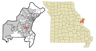
Northwoods is a city in St. Louis County, Missouri, United States. The population was 4,227 at the 2010 census.

<span class="mw-page-title-main">Oakland, Missouri</span> City in Missouri, United States

Oakland is a city in St. Louis County, Missouri, United States. The population was 1,381 at the 2010 census.

<span class="mw-page-title-main">Pasadena Hills, Missouri</span> City in Missouri, United States

Pasadena Hills is a city in St. Louis County, Missouri, United States. The population was 930 at the 2010 census. The entire city is listed on the National Register of Historic Places.

<span class="mw-page-title-main">Velda City, Missouri</span> City in Missouri, United States

Velda City is a city in St. Louis County, Missouri, United States. The population was 1,420 at the 2010 census.

<span class="mw-page-title-main">Winchester, Missouri</span> City in Missouri, United States

Winchester is a city in St. Louis County, Missouri, United States. The population was 1,447 at the 2020 census.

<span class="mw-page-title-main">Schell City, Missouri</span> City in Missouri, United States

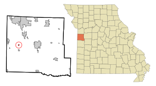
Schell City is a city in northeast Vernon County, Missouri, United States. The population was 249 at the 2010 census.

<span class="mw-page-title-main">Lake Annette, Missouri</span> City in Missouri, United States

Lake Annette is a city in Cass County, Missouri, United States. The population was 100 at the 2010 census. It is part of the Kansas City metropolitan area.

<span class="mw-page-title-main">Moline Acres, Missouri</span> City in Missouri, United States

Moline Acres is a city in St. Louis County, Missouri, United States. The population was 2,442 at the 2010 census.

<span class="mw-page-title-main">Warson Woods, Missouri</span> City in Missouri, United States

Warson Woods is a city in St. Louis County, Missouri, United States. The population was 1,962 at the 2010 census.

References

  1. "ArcGIS REST Services Directory". United States Census Bureau. Retrieved August 28, 2022.
  2. 1 2 U.S. Geological Survey Geographic Names Information System: Bosworth, Missouri
  3. 1 2 "U.S. Census website". United States Census Bureau . Retrieved January 31, 2008.
  4. "Explore Census Data". data.census.gov. Retrieved December 23, 2021.
  5. Eaton, David Wolfe (1916). How Missouri Counties, Towns and Streams Were Named. The State Historical Society of Missouri. pp.  271.
  6. "Post Offices". Jim Forte Postal History. Archived from the original on March 6, 2016. Retrieved September 10, 2016.
  7. "US Gazetteer files 2010". United States Census Bureau. Archived from the original on January 25, 2012. Retrieved July 8, 2012.
  8. "Census of Population and Housing". Census.gov. Retrieved June 4, 2015.
  9. "U.S. Census website". United States Census Bureau . Retrieved July 8, 2012.