Bohemian Flats

Last updated
Bohemian Flats Park
Washington Avenue Bridge Minneapolis.jpg
Bohemian Flats, 2005
Bohemian Flats
Type Urban park
Location Minneapolis, Minnesota, United States
Coordinates 44°58′31″N93°14′29″W / 44.975278°N 93.241389°W / 44.975278; -93.241389
StatusOpen all year
Website Bohemian Flats

Bohemian Flats Park is a park in Minneapolis, Minnesota, United States on the west bank of the Mississippi River near the Washington Avenue Bridge and next to the University of Minnesota campus. The area, once known as Little Bohemia, was the site of a shanty town as Minneapolis was incorporated in 1867. European immigrants seeking employment in the city or at the mills at the nearby St. Anthony Falls settled there. The former housing structures and historic buildings no longer remain. The park is managed by the Minneapolis Park and Recreation Board as part of the Mississippi Gorge Regional Park, and it lies within the Mississippi National River Recreation Area.

Contents

History

Immigrant groups

The area known as "Bohemian Flats" was so named because a high percentage of the population came from Central Europe; the majority of the families occupying the area were Slovaks, Swedes, Czechs (Bohemians), and Germans. The census of 1900 [1] shows the demographics of the area. Despite the name, the people who lived in Bohemian Flats were mostly Slovaks. A predominantly Bohemian community, from what is now the Czech Republic, lived in the Upper Levee in St. Paul before moving to the neighborhood around West 7th Street, where the Czech-Slovak Protective Society (CSPS) Hall still stands at the corner of Michigan Street. [2] The Bohemians were followed by Italian immigrants to the Upper Levee. Many of these families moved to neighborhoods around West 7th Street and Payne Avenue, but Italian communities continued to occupy the Upper Levee and Swede Hollow until the houses were razed by the city in the 1950s. [3]

OriginNorth of BridgeSouth of Bridge
Slovaks61322
Swedes12385
Czech90105
Irish418
Norwegian272
German523

Obviously there was oceans and whole continents lying between this place and the area above, even though only a bridge separates them. [4]

Because it was a melting pot of nationalities, Bohemian Flats was known by other names as well. In early times, it was known as "The Danish Flats", due to Danish population. Later it would be called Little Bohemia, Connemara Patch, Little Ireland, Little Lithuania, Cabbage Patch, and in the spring time, it was known as Little Venice. With all of the different nationalities, many "mini" communities were formed.

Bohemian Flats below the Washington Avenue Bridge in Minneapolis, Minnesota, c. 1885. Photographer: F. M. Laraway Washington Avenue Bridge 1885.jpg
Bohemian Flats below the Washington Avenue Bridge in Minneapolis, Minnesota, c. 1885. Photographer: F. M. Laraway

Many of the flats residents worked at the Heinrich Brewery [5] at the south end or the Noerenberg Brewery [6] (1870) at the north end of the flats. Others worked in the sawmills and flour mills farther upstream. The St. Paul and Pacific Railroad bridge (1887) and the original Washington Avenue bridge (1884) went over the flats with houses directly beneath. [7] The residents of the flats were responsible for establishing churches in Northeast Minneapolis, Cedar-Riverside, and Prospect Park, and traveled to the city center and beyond for their jobs. Members of the community likely attended Americanization classes at nearby centers, such as the Pillsbury House [8] in Cedar-Riverside or the Seven Corners Library. [9]

The population of the Flats grew to over 1,000 residents at its height. [9] Due to proximity and affordability, settling on the Flats was an advantage to the immigrants who worked at the nearby mills and breweries. Residents were also able to retrieve lumber that fell into the river to build their homes or to sell for additional income.

The homes built on the Flats were no more than shanties. They had no foundation and the structures were often faulty . The Mississippi was known to flood in the spring, which was a problem for the dwellings, because the Flats were not much higher than the normal river level. Each spring the water would rise and flood the area, many times taking the poorly constructed houses with the receding waters. For those at the Bohemian Flats, spring floods often meant packing up your belongings and temporarily living with friends or family; there were even reports of the residents camping out in the abandoned Noerenberg Brewery until the water subsided. The river would also carry belongings away, including sheds and wood piles, and chickens would be found drowned after the water receded. One of the most devastating floods in the Twin Cities area took place in April 1952, [10] leading to the evacuation of the entire Upper Levee community and portions of the West Side Flats. [11]

Structure and changes

The Flats comprised three major areas: the upper flats, and the north and south lower flats. The houses on the upper flats were popular and in high demand because they were not affected by the flood waters in the spring. The upper and lower flats were separated by a cliff. Houses on the upper flats rented for about $15–20 a year, compared to the lower flats which ranged from $.50–2.00.[ citation needed ] Reaching the lower flats required a descent of 79 stairs. [12] The upper flats had more room than the lower flats, comparatively. By 1885 the west side flats were covered with small, frame dwellings from the foot of 2 1/2 Street South to the foot of 20th Avenue South. By 1892 formal streets had appeared, which were named Wood, Cooper, and Mill reflecting the occupations of many of the residents.

In 1890, the St. Anthony Falls Water Power Company ordered that the City of Minneapolis stop dumping their garbage directly into the Mississippi River, giving them only a few days to find a new place to dispose of waste. Barred access to the river, Dr. Kilvington, head of the Minneapolis Board of Health, and his sanitation committee found a loophole by depositing trash on the banks of the Mississippi instead. It was determined that the flats beneath the Washington Avenue bridge would provide a satisfactory location for the dump, "away from the settled city." This facility, described in an appropriately titled Minneapolis Tribune article about the flats called "Life at the Dump," was extremely hazardous to the health of the residents at the Bohemian Flats. [13] In 1899, the State Board of Health ordered Kilvington's replacement, C.T. Frane, to find a new location for the city dump, after closing the location at the flats. This article noted that city residents had been dumping their "cess-pools" (toilet waste) beneath the bridge in addition to trash. [13]

The Bohemian Flats area being used to study structural members of the collapsed I-35W Mississippi River bridge, which was about 150 yards (140 m) upriver 35wbridge2.jpg
The Bohemian Flats area being used to study structural members of the collapsed I-35W Mississippi River bridge, which was about 150 yards (140 m) upriver

Minneapolis had long wanted to move the head of commercial navigation on the Mississippi from St. Paul to Minneapolis. They succeeded with the opening of Lock and Dam No. 1, which extended commercial navigation to the west bank just above the Washington Ave. bridge - Bohemian flats. In 1915, some residents were issued eviction notices in anticipation of the completion of Lock and Dam No. 1 in 1917. In 1931 the city evicted the residents of Bohemian Flats just north of the municipal levee and built a coal barge facility. In 1935 a brick terminal building was built at the northern end of the municipal levee with an adjoining railroad yard. A concrete grain loading facility was constructed near the southern end of the levee by Archer, Daniels, Midland Company. The houses on the intermediate terrace were removed shortly after. Eminent domain was used by the city to force evacuations of the area. [14] The last resident of the Flats stayed until the construction of the current Washington Avenue Bridge in 1963. Joseph A. Kieferle, 80, had called the Flats home for fifty years. A lone abandoned house remained in the shadow of a Great Northern Oil tank until the late 1960s. [14] In the 1940s a large brick building was built for housing single men who worked at the mills. This building was soon inhabited by families. The community began to use this building as a community center.

21st century

On August 1, 2007, the I-35W Bridge collapsed, killing 13 people and injuring 145. [15] Much of the bridge debris was temporarily stored at the Bohemian Flats as part of the ongoing investigation of the collapse; it was removed to a storage facility in Afton, Minnesota, in the fall of 2010. [16] [17] The flats area was used as a construction staging area for contractors renovating the nearby Franklin Bridge in 2015–2016. [17]

Bohemian Flats Park

Bohemian Flats is a public park in Minneapolis that is part of the Mississippi Gorge Regional Park, [18] a unit of the Minneapolis Park and Recreation Board. [19] Recreational amenities at Bohemian Flats include biking path, garden, picnic areas, river cruises/private charters, and restroom facilities.

Bohemian Day

Bohemian Day on August 20 was organized by artists and Bohemian Gera Pobuda to celebrate the traditions as well as the immigrants who lived in the Bohemian Flats during the first three decades of the 20th century. These immigrants included Czechs, Slovaks, Germans, Scandinavians, Irish, and Italians. The Lipa Slovak Dancers dress in traditional costumes all made by a woman from Slovakia. The Lipa Slovak group is named after the national tree of Slovakia, the linden tree [20] in North America. They perform several times per year at events such as Czech festivals and the Festival of Nations. [21]

See also

Footnotes

  1. "1900 Census | 1900 U.S. Federal Census Records". www.censusrecords.com. Retrieved July 20, 2019.
  2. "At Our Hall – Czech and Slovak Sokol Minnesota". www.sokolmn.org. Retrieved 2017-03-21.
  3. "Sophie Shefel with a group of children in Bohemian Flats, Minneapolis | Who Built Our Capitol?". www.whobuiltourcapitol.org. Retrieved 2017-03-21.
  4. Rølvaag, Ole Edvart (1985). The Boat of Longing . New York: Harber Brothers (1922) St. Paul: Minnesota Historical Society Press, Borealis Books, 1985), 108. ISBN   9780873511841.
  5. "Heinrich Brewing Association - MN 102c | Old Breweries Information | Breweriana Values". 21 August 2013. Retrieved July 20, 2019.
  6. "F.D.Noerenberg Brewery - MN 110c | Old Breweries Information | Breweriana Values". 21 August 2013. Retrieved July 20, 2019.
  7. "FSTS Sources - Papers - ARCHAEOLOGY OF THE CENTRAL MINNEAPOLIS RIVERFRONT: PART 1 Archaeological Site Inventory - Brewery Flats". www.fromsitetostory.org. Retrieved 2017-03-21.
  8. Hampl, Patricia (July 20, 1966). "The West Bank-- Reminiscences". housesofworship.umn.edu. Retrieved July 20, 2019.
  9. 1 2 Minnesota, University of (2014-12-18). "Living with the Mississippi: The Bohemian Flats". River Life. Archived from the original on 2017-03-22. Retrieved 2017-03-21.
  10. "The Flood of 1952 - Mississippi National River and Recreation Area (U.S. National Park Service)". www.nps.gov. Retrieved July 20, 2019.
  11. Minnesota, University of (2015-01-08). "Living with the Mississippi: Life on a Floodplain". River Life. Archived from the original on 2017-03-22. Retrieved 2017-03-21.
  12. "First Hand Reflections - Bohemian Flats Connections to the City". sites.google.com. Retrieved 2017-03-21.
  13. 1 2 Minnesota, University of (2015-02-05). "Living with the Mississippi: Dr. Kilvington's Dumping Ground". River Life. Archived from the original on 2017-03-22. Retrieved 2017-03-21.
  14. 1 2 "Bohemian Flats Day". www.bohemianflatsday.com. Retrieved 2017-03-21.
  15. "I-35W St. Anthony Falls Bridge - MnDOT". www.dot.state.mn.us. Retrieved 2017-03-21.
  16. "KSTP TV - Minneapolis and St. Paul - Page not found". 2012-03-20. Archived from the original on 2012-03-20. Retrieved 2017-03-21.{{cite web}}: Cite uses generic title (help)
  17. 1 2 "Minneapolis pier rocks now squatting in Bohemian Flats". Star Tribune. Retrieved 2017-03-21.
  18. "Bohemian Flats Park". www.minneapolisparks.org. Retrieved 2017-03-21.
  19. "Minneapolis Park & Recreation Board" . Retrieved July 20, 2019.
  20. "State Symbols - Coat of Arms, Anthem, Seal | Slovak-Republic.org". www.slovak-republic.org. Retrieved 2017-03-21.
  21. Cindy Collins, "Bohemian return to the Flats" The Bridge, September 23, 2005

Related Research Articles

<span class="mw-page-title-main">Mississippi River</span> Major river in the United States

The Mississippi River is the primary river, and second-longest river, of the largest drainage basin in the United States. From its traditional source of Lake Itasca in northern Minnesota, it flows generally south for 2,340 miles (3,766 km) to the Mississippi River Delta in the Gulf of Mexico. With its many tributaries, the Mississippi's watershed drains all or parts of 32 U.S. states and two Canadian provinces between the Rocky and Appalachian mountains. The main stem is entirely within the United States; the total drainage basin is 1,151,000 sq mi (2,980,000 km2), of which only about one percent is in Canada. The Mississippi ranks as the thirteenth-largest river by discharge in the world. The river either borders or passes through the states of Minnesota, Wisconsin, Iowa, Illinois, Missouri, Kentucky, Tennessee, Arkansas, Mississippi, and Louisiana.

<span class="mw-page-title-main">Fridley, Minnesota</span> City in Anoka County, Minnesota, USA

Fridley is a city in Anoka County, Minnesota, United States. Its population was 29,590 at the 2020 census. Fridley was incorporated in 1949 as a village, and became a city in 1957. It is part of the Minneapolis–Saint Paul metropolitan area as a northern "first-ring" or "inner-ring" suburb. Most of the growth in Fridley occurred between 1950 and 1970. Fridley borders Minneapolis to the southwest. Neighboring first-ring suburbs are Columbia Heights to the south and Brooklyn Center to the west, across the Mississippi River.

<span class="mw-page-title-main">Des Moines River</span> River in Iowa, United States

The Des Moines River is a tributary of the Mississippi River in the upper Midwestern United States that is approximately 525 miles (845 km) long from its farther headwaters. The largest river flowing across the state of Iowa, it rises in southern Minnesota and flows across Iowa from northwest to southeast, passing from the glaciated plains into the unglaciated hills near the capital city of Des Moines, named after the river, in the center of the state. The river continues to flow to a southeastern direction away from Des Moines, later flowing directly into the Mississippi River.

<span class="mw-page-title-main">Stone Arch Bridge (Minneapolis)</span> Bridge crossing the Mississippi river in Minnesota, United States

The Stone Arch Bridge is a former railroad bridge crossing the Mississippi River at Saint Anthony Falls in downtown Minneapolis, Minnesota. It is the only arched bridge made of stone on the entire Mississippi River. It is the second oldest bridge on the river next to Eads Bridge. The bridge was built to connect the railway system to the new Union Depot, which at that time was planned to be built between Hennepin Avenue and Nicollet Avenue. The bridge was completed in 1883, costing $650,000 at the time. 117 Portland Avenue is the general address of the historic complex.

<span class="mw-page-title-main">Nicollet Island</span> Island on the Mississippi River in central Minneapolis, Minnesota, USA

Nicollet Island is an island in the Mississippi River just north of Saint Anthony Falls in central Minneapolis, Minnesota. According to the United States Census Bureau the island has a land area of 194,407 square metres (0.075 sq mi) and a 2000 census population of 144 persons. The island makes up a large part of the city-designated Nicollet Island/East Bank neighborhood. The island is named for cartographer Joseph Nicollet, who mapped the Upper Mississippi in the 1830s.

<span class="mw-page-title-main">Washington Avenue Bridge (Minneapolis)</span> Bridge in Minneapolis, Minnesota

The Washington Avenue Bridge carries County Road 122 and the METRO Green Line light rail across the Mississippi River in Minneapolis and connects the East Bank and West Bank portions of the University of Minnesota campus. The bridge has two decks, with the lower deck designated for motor vehicle traffic and light rail trains and the upper deck used for pedestrians and bicycles. It is a utilitarian structure with simple architecture, but it has cultural significance because thousands of students, faculty, staff, and visitors walk across it every day.

<span class="mw-page-title-main">10th Avenue Bridge</span> Bridge in Minneapolis, Minnesota

The 10th Avenue Bridge crosses the Mississippi River near downtown Minneapolis, Minnesota and also in proximity to the University of Minnesota. The bridge historically was called the Cedar Avenue Bridge from days prior to the construction of the I-35W bridge when it connected to Cedar Ave. The bridge connects 10th Avenue Southeast, on the east side of the Mississippi River to 19th Avenue South, on the west side. The Seven Corners area of the Cedar-Riverside, Minneapolis neighborhood is at the south end of the bridge. The downstream end of the lower Saint Anthony Falls lock and dam extends under the bridge. The historic Southeast Steam Plant is also nearby.

<span class="mw-page-title-main">Cedar-Riverside, Minneapolis</span> Neighborhood in Hennepin, Minnesota, United States

Cedar-Riverside, also referred to as the West Bank, or simply Riverside, is a neighborhood within Minneapolis, Minnesota. Its boundaries are the Mississippi River to the north and east, Interstate 94 to the south, and Hiawatha Avenue and Interstate 35W to the west. It has a longstanding tradition of cultural diversity and settlement, with a robust arts tradition.

<span class="mw-page-title-main">Lower Ninth Ward</span> Neighborhood in New Orleans, Louisiana, US

The Lower Ninth Ward is a neighborhood in the city of New Orleans, Louisiana. As the name implies, it is part of the 9th Ward of New Orleans. The Lower Ninth Ward is often thought of as the entire area within New Orleans downriver of the Industrial Canal; however, the City Planning Commission divides this area into the Lower Ninth Ward and Holy Cross neighborhoods.

<span class="mw-page-title-main">Mississippi National River and Recreation Area</span> National Park Service area in the United States

The Mississippi National River and Recreation Area is a 72-mile (116 km) and 54,000-acre (22,000 ha) protected corridor along the Mississippi River through the Minneapolis–Saint Paul metro in the U.S. state of Minnesota, from the cities of Dayton and Ramsey, to just downstream of Hastings. This stretch of the upper Mississippi River includes natural, historical, recreational, cultural, scenic, scientific, and economic resources of national significance. This area is the only national park site dedicated exclusively to the Mississippi River. The Mississippi National River and Recreation Area is sometimes abbreviated as MNRRA or MISS, the four letter code assigned to the area by the National Park Service. The Mississippi National River and Recreation Area is classified as one of four national rivers in the United States, and despite its name it is technically not one of the 40 national recreation areas.

<span class="mw-page-title-main">Intercity Bridge</span> Bridge in Minneapolis-St. Paul, Minnesota

The Intercity Bridge, more commonly known as the Ford Parkway Bridge, is a reinforced concrete arch bridge that spans the Mississippi River between Minneapolis, Minnesota and St. Paul, Minnesota, United States. It connects 46th Street in Minneapolis with Ford Parkway in Saint Paul. The bridge is historically significant as one of the largest reinforced concrete bridges ever built in Minnesota. It was built in 1925-1927 by James O. Heyworth, Inc. and was designed by Martin Sigvart Grytbak. The Intercity Bridge was listed on the National Register of Historic Places in 1989. It is notable as one of the monumental concrete rib-arch bridges spanning the high river bluffs along the Mississippi River, along with the Franklin Avenue Bridge, the Third Avenue Bridge, the 10th Avenue Bridge, and the Robert Street Bridge.

<span class="mw-page-title-main">Northeast, Minneapolis</span> Community of Minneapolis

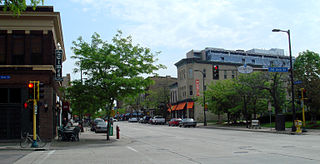
Northeast is a defined community in the U.S. city of Minneapolis that is composed of 13 smaller neighborhoods whose street addresses end in "NE". Unofficially it also includes the neighborhoods of the University community which have "NE" addresses, and the entirety of the Old Saint Anthony business district, which sits on the dividing line of "NE" and "SE" addresses. In the wider community, this business district, which is the oldest settlement in the city, is often identified as the heart of Northeast, in part because it lies across the Mississippi River from Downtown Minneapolis. Northeast is sometimes referred to as "Nordeast", reflecting the history of northern and eastern European immigrants and their language influence.

<span class="mw-page-title-main">Mill District, Minneapolis</span> Neighborhood in Minneapolis, Minnesota, United States

<span class="mw-page-title-main">Dayton's Bluff, Saint Paul</span> Neighborhood in Ramsey, Minnesota, United States

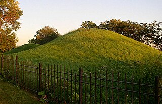
Dayton's Bluff is a neighborhood located on the east side of the Mississippi River in the southeast part of the city of Saint Paul, Minnesota which has a large residential district on the plateau extending backward from its top. The name of the bluff commemorates Lyman Dayton, for whom a city in Hennepin County was also named. On the edge of the southern and highest part of Dayton's Bluff, in Indian Mounds Park, is a series of seven large aboriginal mounds, 4 to 18 feet high, that overlook the river and the central part of the city.

<span class="mw-page-title-main">History of Saint Paul, Minnesota</span> Aspect of history

Saint Paul is the second largest city in the U.S. state of Minnesota, the county seat of Ramsey County, and the state capital of Minnesota. The origin and growth of the city were spurred by the proximity of Fort Snelling, the first major United States military installation in the area, as well as by the city's location on the northernmost navigable port of the Upper Mississippi River.

<span class="mw-page-title-main">June 2008 Midwest floods</span> Weather outbreak that lead to flooding in the American Midwest

The June 2008 Midwestern United States floods were flooding events which affected portions of the Midwestern United States. After months of heavy precipitation, a number of rivers overflowed their banks for several weeks at a time and broke through levees at numerous locations. Flooding continued into July. States affected by the flooding included Illinois, Indiana, Iowa, Michigan, Minnesota, Missouri and Wisconsin. The American Red Cross assisted the victims of flooding and tornadoes across seven states and the National Guard was mobilized to assist in disaster relief and evacuation.

<span class="mw-page-title-main">Iowa flood of 2008</span> Natural Disaster (flood) in Iowa, US from June 8 – July 1, 2008

The Iowa flood of 2008 was a hydrological event involving most of the rivers in eastern Iowa which began June 8 and continued until July 1. Flooding continued on the Upper Mississippi River in the southeastern area of the state for many more days. The phrase "Iowa's Katrina" was often heard.

<span class="mw-page-title-main">West Seventh, Saint Paul</span> Neighborhood in Ramsey, Minnesota, United States

West Seventh is a neighborhood in Saint Paul, Minnesota, United States. This area is colloquially known as the West End, and is not to be confused with the West Side, a different neighborhood. The West End lies at the base of Summit Hill and along the western bluffs of the Mississippi River, spanning the entire length of West Seventh Street, or Old Fort Road; it is also known as the Fort Road area. Fort Road was a historic Native American and fur trader path along the Mississippi River from downtown Saint Paul to Fort Snelling.

<span class="mw-page-title-main">Mississippi Gorge Regional Park</span> Urban park in Minnesota, United States

Mississippi Gorge Regional Park is a regional park along the east and west bluffs of the Mississippi River in the cities of Minneapolis and Saint Paul in the U.S. state of Minnesota. The two-city park area is between Mississippi river miles 848 and 852, from just south of Northern Pacific Bridge Number 9 to just north of Minnehaha Regional Park, and lies within the Mississippi National River and Recreation Area. The park area protects scenic and natural areas of the Mississippi River gorge, the only true gorge along the entire length of the 2,320-mile (3,730 km) river.

References