Mississippi River Trail

Last updated
Mississippi River Trail
Mississippi River Trail - Algiers Point, New Orleans.jpg
The Mississippi River Trail in Algiers Point, Louisiana, with a view of the Mississippi River, French Quarter, New Orleans skyline.
Length3,000 miles (4,800 km)
LocationSeveral U.S. states
Designation USBR 45 (2009).svg
  • U.S. Bicycle Route 45
  • Mississippi River Trail
Trailheads
Surface Paved

The Mississippi River Trail (abbreviated MRT) is a designated bicycle and pedestrian trail that traverses the shores of the Mississippi River in the United States. The trail extends from the headwaters at Lake Itasca in Minnesota to near the mouth of the river in Venice, Louisiana. Much of the trail’s 3,000 miles (4,800 km) follows roadways used by motor vehicles, although some of the route is on multi-use trails. The segment in Minnesota has been designated as U.S. Bicycle Route 45 (USBR 45), part of the U.S. Bicycle Route System.

Contents

Designation and signage

Mississippi River Trail sign Mississippi River Trail 10 states 1 river icon.jpg
Mississippi River Trail sign

The Mississippi River Trail route marker is based on a 2012 design that the Federal Highway Administration (FHWA) has allowed several states, including Illinois, Kentucky, and Tennessee, to use as U.S. Bicycle Route markers. [1] The design features a green background with a white triangle and a bicycle symbol. [2] However, the Mississippi River Trail's marker bears the abbreviation "MRT" in place of a numeric route designation. [3]

The portion of the Mississippi River Trail in Minnesota was designated as U.S. Bicycle Route 45 in 2013. [4] [5] Long-range plans call for the rest of the MRT to be designated as USBR 45, and for the southernmost segment near New Orleans to be concurrently designated as USBR 51. [6]

By the time the Minnesota Department of Transportation (MnDOT) successfully proposed designating the MRT as USBR 45, planning for the trail was already well underway. Local trail partners did not want to spend additional funds and weaken the MRT brand by installing the USBR signs  a requirement for USBR designation  alongside the MRT signs. MnDOT secured approval from the Federal Highway Administration to display only the MRT shield for the time being. [3] [7]

Route description

The trail is divided into three sections: Northern, Central, and Southern. [8] In some locations trails are along both sides of the river.

Northern section

Minnesota

The north entrance of Minnehaha Trail, a signed portion of the MRT in the Minneapolis-St. Paul area. Minnehaha Trail north entrance Minneapolis June 2020.jpg
The north entrance of Minnehaha Trail, a signed portion of the MRT in the Minneapolis-St. Paul area.

The MRT begins at Itasca State Park, near the headwaters of the river. Itasca State Park also contains more than 20 miles (32 km) of paved biking trails. After it leaves the park, the MRT winds north along the river, traversing county roads to the city of Bemidji. Here the main trail connects to a number of city and regional trails. From Bemidji, the MRT heads southeast along the Paul Bunyan Trail, a state-developed rail-trail conversion. This 100-mile-long (160 km) paved trail extends from Bemidji to Brainerd.

From Brainerd, the MRT follows county roads, some with marked bike lanes and some with paved shoulders, through the cities of Little Falls and St. Cloud. South of St. Cloud, the surroundings become more urban as the rider approaches the Twin Cities, Minneapolis and St. Paul. The route through the two cities passes the Mississippi National River and Recreation Area that includes St. Anthony Falls, Minnehaha Falls Regional Park, and Fort Snelling State Park, among other protected areas and parks. In Minneapolis, MRT segments appropriate the established Grand Rounds National Scenic Byway trails and Minnehaha Trail. South of St. Paul, the MRT passes through several smaller cities before reaching Lake Pepin. The route passes through Wabasha and Winona on its way to the Wisconsin state line.

Wisconsin

The Wisconsin section of the MRT begins at Prescott and continues along the eastern side of the river all the way to Illinois. The section north of Prairie du Chien primarily follows the Great River Road, while the section south follows various state and county highways. [9] The Wisconsin Department of Transportation has prepared an online publication, The Great River Road Mississippi River Trail Bicycle Map: A Guide for Cycling Along Wisconsin's Great River, which offers a detailed section by section guide of the Wisconsin route complete with road maps, services, campgrounds and route descriptions.

Iowa

Central

Illinois

Missouri

St. Louis Riverfront Trail and Mississippi River Trail, St. Louis, Missouri Mississippi River Trail, Missouri.jpg
St. Louis Riverfront Trail and Mississippi River Trail, St. Louis, Missouri

Kentucky

Southern

Tennessee

The trail enters Obion County from Kentucky along State Route 157 (SR 157) and then turns right onto SR 22 traveling southwesterly. The trail goes along the eastern boundary of Reelfoot National Wildlife Refuge. Near Samburg, the trail turns right onto SR 21 and follows the south shore of Reelfoot Lake. It also passes near Reelfoot Lake State Park.

The trail enters into Lake County and turns left onto Bluebank Road, right onto Wynnburg–Keefe Road, left onto Madie Church to Keefe Road, right onto Madie Thompson Road, left onto Madie Road, and right onto Gratio Road, entering the town of Ridgely, Tennessee. Through Ridgely, the trail travels along Poplar Street, Main Street, and Depot Street (Levee Road). From here, the trail travels along SR 181, also known as Great River Road.

The trail enters Dyer County and crosses over Interstate 155 (I-155). It continues south on SR 181 for several miles until it crosses over the Forked Deer River and into Lauderdale County, Tennessee. From here, the trail continues east on SR 88 and turns right onto Porter's Gap Road. Then the trail turns right onto Edith–Nankipoo Road and right onto Hobe Webb Road, traveling near the Chickasaw National Wildlife Refuge. The trail turns left onto Chisholm Lake Road, right onto Craig School Road (turning into Turkey Hill Road), and then left onto SR 19. Then the trail turns right onto Lightfoot Luckett Road then right onto SR 87, then left onto SR 371. The trail turns right onto Cooper Creek Road and then right onto U.S. Route 51 (US 51), crossing into Tipton County over the Hatchie River.

Continuing south along US 51, the trail turns right onto Leigh's Chapel Road, left onto Flat Iron Road (turning into Simmons Street), right onto Murphy Avenue (turning into Bride Road), left onto Garland Drive, and right onto Garland Detroit Road (turning into Detroit Road, then Jamestown Road, then Randolph Road), following the top ridge of the 2nd Chickasaw Bluff. Passing through the town of Randolph, Tennessee, the trail turns right onto Needham Road and right onto SR 59. The trail then turns south onto Richardson Landing road, turns right onto Pryor Road (turning into Bluff Road), and makes a left in order to stay on Bluff Road. The trail turns right onto Quito–Drummonds Road and right onto Ray Bluff Road, entering Shelby County.

The trail continues south along Ray Bluff Road (turning into New Bethel Road), right onto Bass Road, right again onto New Bethel Road, right onto West Union Road, right onto Herring Hill Road, and straight onto Riverbluff Road (turning into Bluff Road). The trail travels along the ridge of the 3rd Chickasaw Bluff and passes through Meeman-Shelby Forest State Park. In the community of Shelby Forest, Tennessee, the trail turns right onto Benjestown Road, right onto Island Forty Road (turning into Ramsey Road), and right back onto Benjestown Road. Then the trail turns left onto South Circle Road (turning into East Circle Road), right onto Northaven Drive, and right onto SR 388 (North Watkins Street), passing through the Northaven area and crossing over the Loosahatchie River into the Frayser community of Memphis.

Once in Memphis, the route turns right onto Millington Road, right onto Carrolton Road, left onto Benjestown Road, and right onto Whitney Avenue, passing by General DeWitt Spain Airport and over the Wolf River. The trail turns south onto North Mud Island Road (turning into Island Drive) and passes through the Harbortown neighborhood. Then the trail turns left onto A.W. Willis Avenue over Wolf River Harbor, right onto Front Street (passing next to the Pyramid Arena), passes under I-40 and the Hernando De Soto Bridge, turns right onto Jefferson Avenue, and left onto Riverside Drive, entering Downtown Memphis. From here, the trail continues south on Riverside Drive, passing by Mud Island, the MATA Trolley riverfront loop, and the South Bluffs neighborhood. The trail goes along the paths in Tom Lee Park and the Riverwalk Trail system in Downtown Memphis.

After this, the official trail is unclear. According to the MRT website, the trail travels under the Harahan Bridge and the Frisco Bridge, up the side of the 4th Chickasaw Bluff, and onto a sidewalk on the Memphis-Arkansas Bridge. A route following the South side of the Memphis-Arkansas bridge from E.H. Crump [10] park has been documented. [11] Construction has been completed on a multi-use trail for pedestrians and cyclists along the north side of the Harahan bridge. [12] [13]

Arkansas

Mississippi

Louisiana

See also

Related Research Articles

<span class="mw-page-title-main">Great River Road</span> Highway designation

The Great River Road is a collection of state and local roads that follow the course of the Mississippi River through ten states of the United States. They are Minnesota, Wisconsin, Iowa, Illinois, Missouri, Kentucky, Tennessee, Arkansas, Mississippi and Louisiana. It formerly extended north into Canada, serving the provinces of Ontario and Manitoba. The road is designated as both a National Scenic Byway and an All-American Road in several states along the route.

<span class="mw-page-title-main">Reelfoot Lake</span> Lake in Tennessee, United States

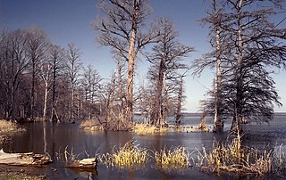
Reelfoot Lake is a shallow natural lake located in the northwest portion of the U.S. state of Tennessee, in Lake and Obion Counties. Much of it is swamp-like, with bayou-like ditches connecting more open bodies of water called basins, the largest of which is called Blue Basin. Reelfoot Lake is noted for its bald cypress trees and its nesting pairs of bald eagles.

<span class="mw-page-title-main">U.S. Route 65</span> Numbered U.S. Highway in the United States

U.S. Route 65 is a north–south United States highway in the southern and midwestern United States. The southern terminus of the route is at U.S. Route 425 in Clayton, Louisiana. The northern terminus is at Interstate 35 just south of Interstate 90 in Albert Lea, Minnesota. Parts of its modern route in Iowa and historic route in Minnesota follow the old Jefferson Highway.

<span class="mw-page-title-main">Chickasaw Bluff</span>

The Chickasaw Bluff is the high ground rising about 50 to 200 feet (20–60 m) above the Mississippi River flood plain between Fulton in Lauderdale County, Tennessee and Memphis in Shelby County, Tennessee.

<span class="mw-page-title-main">Wisconsin Highway 35</span> Highway in Wisconsin

State Trunk Highway 35 is a Wisconsin state highway running north–south across western Wisconsin. It is 412.15 miles in length, and is the longest state highway in Wisconsin. Portions of WIS 35 are part of the Great River Road.

<span class="mw-page-title-main">Old Spanish Trail (auto trail)</span> Auto trail across the United States

The Old Spanish Trail was an auto trail that once spanned the United States with almost 2,750 miles (4,430 km) of roadway from ocean to ocean. It crossed eight states and 67 counties along the southern border of the United States. Work on the auto highway began in 1915 at a meeting held at the Battle House Hotel in Mobile, Alabama; and, by the 1920s, the trail linked St. Augustine, Florida, to San Diego, California, with its center and headquarters in San Antonio, Texas. The work at San Antonio, and indeed nationally, was overseen by an executive committee consisting of prominent San Antonio businessmen which met at the Gunter Hotel weekly.

<span class="mw-page-title-main">U.S. Route 41 in Florida</span> Highway in Florida

U.S. Highway 41 (US 41) in the state of Florida is a north–south United States Highway. It runs 479 miles (771 km) from Miami in South Florida northwest to the Georgia state line north of the Lake City area. Within the state, US 41 is paralleled by Interstate 75 (I-75) all the way from Miami to Georgia, and I-75 has largely supplanted US 41 as a major highway.

<span class="mw-page-title-main">Southwest LRT Trail</span> Shared-use path in Minneapolis

Southwest LRT Trail is a system of shared-use paths for bicycles and pedestrian paths that extends through several western suburbs of Minneapolis, Minnesota. They are operated by the Three Rivers Park District. Two former rail corridors originally built by the Minneapolis and St. Louis Railway were acquired and converted to trails in anticipation of the Southwest Corridor light rail project. The two former railway corridors are now divided into three distinct trails.

<span class="mw-page-title-main">History of Randolph, Tennessee</span>

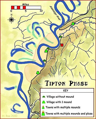
Randolph is an unincorporated rural community in Tipton County, Tennessee, United States, located on the banks of the Mississippi River. The lands of the Mississippi River Basin were inhabited by Paleo-Indians and later Native American tribes of the Mississippian culture for thousands of years. The Tipton phase people and the Chickasaw Indian tribe populated the Mississippi River valley near Randolph during the Mississippian period. In 1541, Spanish explorer Hernando de Soto crossed the Mississippi River at or near Randolph. French explorer Cavelier de La Salle built the first French fortification at or near Randolph on his 1682 canoe expedition of the Mississippi River.

<span class="mw-page-title-main">Tennessee State Route 21</span> State highway in Tennessee, United States

State Route 21 (SR 21) is a two lane highway that runs from the Mississippi River west of Tiptonville, Tennessee to the Kentucky state line north of Union City. This road provides access to Reelfoot Lake State Park.

U.S. Bicycle Route 20 (USBR 20) is a U.S. Numbered Bicycle Route that is planned to run from the Oregon Coast to Marine City, Michigan. As of 2021, sections of the route in Washington state and Michigan have been approved by the American Association of State Highway and Transportation Officials (AASHTO), comprising 387 miles (623 km).

<span class="mw-page-title-main">Cycling in Minnesota</span>

Cycling in Minnesota is a popular form of recreation, commuting, and competitive sport that has grown in prominence over the years. It has been a popular activity in the state since the late 19th century.

<span class="mw-page-title-main">Tennessee State Route 59</span> Highway in Tennessee

State Route 59 is a state highway in Tennessee. It runs from the Mississippi River to just north of Somerville passing through Tipton and Fayette counties. Excluding the portion where it is concurrent with US 51 in Covington, which is 4-lane highway, it is a two-lane rural highway throughout its length and carries a 55 miles per hour (89 km/h) speed limit except when it passes through towns, in which case this speed limit can be significantly less.

U.S. Bicycle Route 66 (USBR 66) is a United States Bicycle Route that follows the former U.S. Route 66 (US 66) across the United States. The first section of the route, spanning 358 miles (576 km) between Baxter Springs, Kansas, and St. Louis, Missouri, was designated as USBR 66 in 2018. A second section was designated in 2021 between Santa Monica, California, and the Arizona state line near Needles, California. The Oklahoma section was designated in 2022. The rest of the route remains proposed but not yet designated.

<span class="mw-page-title-main">Minnehaha Trail</span> Shared-use path in Minneapolis

Minnehaha Trail is a 1.5-mile (2.4 km) paved, multi-use trail in Minneapolis, Minnesota, United States, that connects Minnehaha Regional Park and Fort Snelling State Park – two of the most popular recreation destinations in the Twin Cities metro area. The trail is considered a segment of a longer, loosely connected bicycle route system along the Mississippi River. Users of Minnehaha Trail traverse under a forest canopy. The trail received local recognition for its natural beauty, but it was criticized for its worn pavement and lack of signage.

Minnesota Scenic Byways are a system of roads in the U.S. state of Minnesota which pass through areas of scenic, cultural, or recreational significance. There are currently 22 scenic byways in the system with a total length of 2,948 miles (4,744 km). Eight of these byways are also designated as National Scenic Byways, and the North Shore Scenic Drive is further designated as an All-American Road.

U.S. Bicycle Route 30 (USBR 30) is an east–west U.S. Bicycle Route. As of August 2021, it consists of three segments, running though North Dakota, Wisconsin, Ohio, and Pennsylvania in the United States.

U.S. Bicycle Route 81 (USBR 81) is a United States Bicycle Route in the state of Washington. It is planned to travel north–south along the eastern edge of the state from Asotin to the Canadian border near Metaline Falls. The section from Asotin to Clarkston and Tekoa, spanning 103.5 miles (166.6 km), was designated in 2021. USBR 81 also has a child route, USBR 281, that was designated in 2021 and follows U.S. Route 195.

The Mississippi River Scenic Highway was an auto trail in the United States, created in 1919 to connect the US Midwest with the Southern United States. It was expanded to include a branch to Miami.

References

  1. "List of Approved Requests for Interim Approval". Federal Highway Administration. August 3, 2021. Retrieved August 8, 2021.
  2. Federal Highway Administration (June 1, 2012). "Manual on Uniform Traffic Control". Interim Approval for the Optional Use of an Alternative Design for the U.S. Bicycle Route (M1-9) Sign (IA-15).
  3. 1 2 "Best Practices for Signing, Mapping, and Promoting U.S. Bicycle Routes". Toole Design Group for Adventure Cycling Association. August 2016.
  4. Adventure Cycling Association (May 21, 2012). "New U.S. Bicycle Routes Approved" (Press release). Adventure Cycling Association. Retrieved May 22, 2012.
  5. "Mississippi River Trail receives state bikeway designation, becomes first US Bicycle Route in Minnesota" (Press release). Minnesota Department of Transportation. May 21, 2012. Archived from the original on March 15, 2013. Retrieved November 9, 2013.
  6. National Corridor Plan (PDF) (Map). Adventure Cycling Association. August 4, 2021. Retrieved August 8, 2021.
  7. "U.S. Bicycle Route Guide Signing". The National Academies of Sciences, Engineering, and Medicine. 2018.
  8. MRT website
  9. "Map" (PDF). Archived from the original (PDF) on 2015-04-17. Retrieved 2014-09-21.
  10. "E. H. Crump Park".
  11. "Mississippi River Crossing". 16 August 2013.
  12. "Mississippi River Trail".
  13. "Big River Crossing".