
Waupaca County is a county in the U.S. state of Wisconsin. As of the 2020 census, the population was 51,812. The county seat is Waupaca. The county was created in 1851 and organized in 1853. It is named after the Waupaca River, a Menominee language name meaning 'white sand bottom', 'pale water', or 'tomorrow river'.

Shawano County is a county located in the U.S. state of Wisconsin. As of the 2020 census, the population was 40,881. Its county seat is Shawano.

Portage County is a county in the U.S. state of Wisconsin. As of the 2020 census, the population was 70,377. Its county seat is Stevens Point.

Oconto County is a county in the U.S. state of Wisconsin. As of the 2020 census, the population was 38,965. Its county seat is Oconto. The county was established in 1851.

Menominee County is a county in the U.S. state of Wisconsin. As of the 2020 census, the population was 4,255, making it the least populous county in Wisconsin. Its county seat is in the community of Keshena.

Marathon County is a county located in the U.S. state of Wisconsin. As of the 2020 census, the population was 138,013. Marathon County's seat is Wausau. It was founded in 1850, created from a portion of Portage County. At that time the county stretched to the northern border with the upper Michigan peninsula. It is named after the battlefield at Marathon, Greece.

Brown County is a county in the U.S. state of Wisconsin. As of the 2020 census, the population was 268,740, making it the fourth-most populous county in Wisconsin. The county seat is Green Bay, making it one of three Wisconsin counties on Lake Michigan not to have a county seat with the same name. Brown County is part of the Green Bay, WI Metropolitan Statistical Area.

Shawano is a city in Shawano County, Wisconsin, United States. The population was 9,305 at the 2010 census. It is the county seat of Shawano County.

Birnamwood is a village in Marathon and Shawano counties in the U.S. state of Wisconsin. It is part of the Wausau, Wisconsin Metropolitan Statistical Area. The population was 818 at the 2010 census. Of this, 802 were in Shawano County, and 16 were in Marathon County. The village is located mostly within the town of Birnamwood in Shawano County; only a small portion extends into the town of Norrie in adjacent Marathon County. Until the 1990s, Birnamwood was home to the world's largest fiberglass badger. U.S. Route 45 runs through the village.

Green Bay is a town in Brown County in the U.S. state of Wisconsin. The population was 2,035 at the 2010 census. The town is located several miles northeast of the city of Green Bay. The unincorporated community of Champion is located in the town, and the unincorporated communities of Dyckesville and New Franken are located partially in the town.
State Trunk Highway 29 is a state highway running east–west across central Wisconsin. It is a major east–west corridor connecting the Twin Cities and the Chippewa Valley with Wausau and Green Bay. A multi-year project to upgrade the corridor to a four-lane freeway or expressway from Elk Mound to Green Bay was completed in 2005. The expansion served to improve safety on the route, which was over capacity as a two-lane road. The remainder of WIS 29 is two-lane surface road or urban multi-lane road.
Wisconsin's 8th congressional district is a congressional district of the United States House of Representatives in northeastern Wisconsin. It is currently represented by Mike Gallagher, a Republican. Gallagher won the open seat vacated by Reid Ribble in 2016. It is also one of two Congressional Districts to ever elect a Catholic priest, Robert John Cornell.
Briarton is an unincorporated community in Shawano County, Wisconsin, United States, in the Town of Lessor, west of Green Bay.

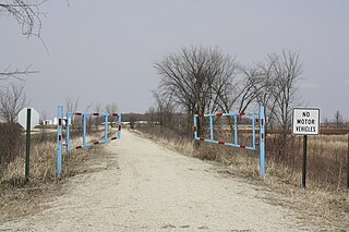
The Wiouwash State Trail is a rail trail in northeastern Wisconsin. Its name is derived from the first two letters of the four counties it traverses: Winnebago, Outagamie, Waupaca, and Shawano. The trail's Tribal Heritage Crossing of Lake Butte des Morts is a nationally designated recreation trail. The trail is used by walkers, hikers, bikers, horseback riders, and snowmobilers during the winter months. Two sections of the trail are complete: 24 miles from Aniwa south to Split Rock and 21 miles from Hortonville south to Oshkosh.
The Fox River State Recreational Trail is a trail along the Fox River in northeastern Wisconsin.
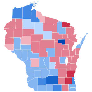
The 2012 United States presidential election in Wisconsin took place on November 6, 2012, as part of the 2012 United States presidential election in which all 50 states plus the District of Columbia participated. Wisconsin voters chose 10 electors to represent them in the Electoral College via a popular vote pitting incumbent Democratic President Barack Obama and his running mate, Vice President Joe Biden, against Republican challenger and former Massachusetts Governor Mitt Romney and his running mate, Congressman Paul Ryan.

There are a variety of schema for dividing Wisconsin into regions.

The Packers Heritage Trail is a self-guided walking tour that traverses locations relating to the history of the Green Bay Packers. 22 of the sites have bronze commemorative plaques. 21 sites are located within a two-mile radius of downtown Green Bay.

The Duck Creek Trail is a crushed limestone trail in Outagamie and Brown Counties in northeast Wisconsin. The Duck Creek Trail spans seven miles (11 km), beginning at the eastern end of the Newton Blackmour State Trail, just east of Vanderheuvel Road in Seymour. The trail continues east through the Oneida Nation of Wisconsin in northern Outagamie County paralleling State Route 54, and continues to the Village of Oneida. The Duck Creek Trail will eventually extend to Pamperin Park in Green Bay.

