
Map
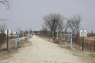
The Nicolet State Trail is an 89-mile state designated trail running through Nicolet National Forest in Florence, Forest, and Oconto Counties in Wisconsin. [1]
The Nicolet State Trail is an 89-mile state designated trail running through Nicolet National Forest in Florence, Forest, and Oconto Counties in Wisconsin. [1]
The trail begins on West Park St. in Gillett, Wisconsin ( 44°53′32″N88°19′04″W / 44.89222°N 88.31778°W ) and travels north through the Nicolet National Forest to the Michigan state line north of Tipler, Wisconsin ( 46°00′35″N88°34′40″W / 46.00972°N 88.57778°W ). [2]
The trail is primarily used by ATV's and UTV's during the summer, but is open to walking, jogging, bicycling, and horseback riding, as well. During the winter, the trail is the main corridor for snowmobiling, cross-country skiing, dog sledding, and snowshoeing. The trail is open to ATV use year-round in Florence and Forest Counties, but is only open to ATV use from May 1 to October 31 in Oconto County. [2]
Horseback riding on the trail is open year-round in Florence County, from May 1 to the end of snowmobiling season in Forest County, and April 15 to November 10 in Oconto County. [2]

Oconto County is a county in the U.S. state of Wisconsin. As of the 2020 census, the population was 38,965. Its county seat is Oconto. The county was established in 1851.

Forest County is a county in the U.S. state of Wisconsin. As of the 2020 census, the population was 9,179. Its county seat is Crandon. The Forest County Potawatomi Community and the Sokaogon Chippewa Community have reservations in Forest County.

Florence County is a county located in the U.S. state of Wisconsin. As of the 2020 census, the population was 4,558, making it the second-least populous county in Wisconsin after Menominee County. Its county seat is Florence.

Oscoda County is a county in the U.S. state of Michigan. As of the 2020 census, the population was 8,219, making it the least populous county in the Lower Peninsula, and the sixth-least populous county in the entire state. The county seat is Mio, an unincorporated community near the center of the county.
Gillett is a city in Oconto County, Wisconsin, United States. The population was 1,386 at the 2010 census. It is part of the Green Bay Metropolitan Statistical Area. The city is adjacent to the Town of Gillett.
Hayward is a city in Sawyer County, Wisconsin, United States, next to the Namekagon River. Its population was 2,318 at the 2010 census. It is the county seat of Sawyer County. The city is surrounded by the Town of Hayward. The City of Hayward was formally organized in 1883.

The Chequamegon–Nicolet National Forest is a 1,530,647-acre (6,194.31 km2) U.S. National Forest in northern Wisconsin in the United States. Due to logging in the early part of the 20th century, very little old growth forest remains. Some of the trees there were planted by the Civilian Conservation Corps in the 1930s. The national forest land trees and vegetation are part of the North Woods Ecoregion that prevails throughout the upper Great Lakes region.
Kettle Moraine is a large moraine in the state of Wisconsin, United States. It stretches from Walworth County in the south to Kewaunee County in the north. It has also been referred to as the Kettle Range and, in geological texts, as the Kettle Interlobate Moraine.

The Kettle Moraine State Forest is a state forest in southeastern Wisconsin. The chief feature of the reserve is the Kettle Moraine, a highly glaciated area. The area contains very hilly terrain and glacial landforms, such as kettles, kames and eskers. The 56,000-acre (23,000 ha) forest is divided into two large and three small units, which are spread across a hundred miles.
Tunkwa Provincial Park is a provincial park on the northern Thompson Plateau in south central British Columbia, Canada. The locality is by road about 16 kilometres (10 mi) north of Logan Lake and 27 kilometres (17 mi) south of Savona.
The Willard Munger State Trail is a system of recreational trails between Hinckley, Minnesota and Duluth, Minnesota. There are three segments to the trail, Hinckley to Duluth Segment, Alex Laveau Memorial Trail, and Matthew Lourey State Trail.
There are 116 lakes named Mud Lake in the U.S. state of Wisconsin. Mud Lake is the most common lake name in the state. Because of the way GNIS is organized some of the names listed below may be for the same lake.

Laona is an unincorporated census-designated place in the town of Laona in Forest County, Wisconsin, United States. U.S. Route 8 travels east–west through the community and Wisconsin Highway 32 travels south and west of the community. The community park has a sign stating that the community donated the 1979 Christmas tree at the nation's capitol. As of the 2010 census, its population is 583.
The Fox River State Recreational Trail is a trail along the Fox River in northeastern Wisconsin.
Aspen Cove at Scofield is a 632-acre (256 ha) recreational property cabin development on the northwest end of Scofield reservoir in the state of Utah. Aspen Cove is primarily a recreation destination. The 2010 population is 7 year round residents and there are over 50 cabins used as second homes. Aspen Cove is less than a 10 mile drive to the town of Scofield, 35 miles to Price, 50 miles to Spanish Fork, and 100 miles to Salt Lake City, Utah.
Mascoutin Valley State Trail is a rail trail in northeastern Wisconsin. The trail is used for walking, bicycling, horseback riding, and snowmobiling during the winter months. The trail can also be used for cross-country skiing and snowshoeing but the trail is not groomed and must be shared with snowmobiles. Numerous miles of snowmobile trails connect to the Mascoutin Valley State Trail.
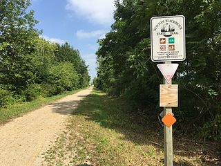
The Newton Blackmour State Trail is a crushed limestone trail in northern Outagamie County in Wisconsin. The trail spans 24 miles (39 km) on a former rail corridor. Its name is derived from the four communities the trail passes through: New London, Shiocton, Black Creek and Seymour. The trail's eastern end in Seymour connects to the Duck Creek Trail, which travels east through the Oneida Nation of Wisconsin and ends in the Village of Oneida.

The Mountain-Bay State Trail is an 83-mile state-designated rail trail in Brown, Marathon, and Shawano Counties in Wisconsin. The trail is the longest rail trail in the state.

The Friendship Trail is a recreation trail in northeastern Wisconsin. The trail is used by walkers, hikers, bikers, horseback riders, and snowmobilers during the winter months. Two sections of the trail are complete: ~14 miles from Winchester east to Fox Crossing and ~4.4 miles from Forest Junction southeast to Brillion. The route consists of asphalt, crushed stone, and wood surfaces. The entire route is located in Winnebago County and Calumet County.

The 36th Assembly District of Wisconsin is one of 99 districts in the Wisconsin State Assembly. Located in northern Wisconsin, the district comprises all Florence, Forest, and Menominee counties, as well as most of Marinette County, central Oconto County, and parts of northern Shawano County. It includes the cities of Crandon, Gillett, Oconto Falls, and Niagara, and the villages of Cecil, Crivitz, Lena, Suring, and Wausaukee. It also contains the Forest County Potawatomi Community, the Sokaogon Chippewa Community, the Menominee Indian Reservation, and the Stockbridge–Munsee Community, and contains most of the Nicolet National Forest, including the Headwaters Wilderness. The district is represented by Republican Jeffrey Mursau, since January 2005.
| | This United States trail or long-distance path–related article is a stub. You can help Wikipedia by expanding it. |