
Eau Claire County is a county located in the U.S. state of Wisconsin. As of the 2020 census, the population was 105,710. Its county seat is Eau Claire. The county took its name from the Eau Claire River.

Dunn County is a county in the U.S. state of Wisconsin. As of the 2020 census, the population was 45,440. Its county seat is Menomonie. Dunn County comprises the Menomonie Micropolitan Statistical Area and is included in the Eau Claire-Menomonie, WI Combined Statistical Area.

Chippewa County is a county located in the U.S. state of Wisconsin. It is named for the historic Chippewa people, also known as the Ojibwe, who long controlled this territory. As of the 2020 census, the population was 66,297. Its county seat is Chippewa Falls. The county was founded in 1845 from Crawford County, then in the Wisconsin Territory, and organized in 1853.

Eau Claire is a city in Eau Claire and Chippewa counties in the U.S. state of Wisconsin. It is the county seat of Eau Claire County. It had a population of 69,421 in 2020, making it the state's eighth-most populous city. It is the principal city of the Eau Claire metropolitan area, locally known as the Chippewa Valley, and is also part of the larger Eau Claire-Menomonie combined statistical area.
Menomonie is a city in and the county seat of Dunn County in the western part of the U.S. state of Wisconsin. The city's population was 16,843 as of the 2020 census.
The University of Wisconsin–Eau Claire – Barron County is a branch campus to the University of Wisconsin–Eau Claire. It is located in Rice Lake, Wisconsin, and is a member of the University of Wisconsin System. As of the 2016–17 school year, there were 497 full and part-time students.

The Red Cedar River in northwestern Wisconsin is a tributary of the Chippewa River. Its name is translation from the Ojibwe Miskwaawaakokaan-ziibi meaning "Abundant with Red Cedar River." According to the Wisconsin Department of Natural Resources, the river flows approximately 100 miles from southwestern Sawyer County to its confluence with the Chippewa southeast of Dunnville in southern Dunn County. It drains portions of eight Wisconsin counties: Barron, Chippewa, Dunn, Polk, Rusk, St. Croix, Sawyer, and Washburn.

The Chippewa River in Wisconsin flows approximately 183 miles (294 km) through west-central and northwestern Wisconsin. It was once navigable for approximately 50 miles (80 km) of its length, from the Mississippi River, by Durand, northeast to Eau Claire. Its catchment defines a portion of the northern boundary of the Driftless Area. The river is easily accessible for bikers and pleasure seekers via the Chippewa River State Trail, which follows the river from Eau Claire to Durand.

The Eau Claire River is a tributary of the Chippewa River in west-central Wisconsin in the United States. It is one of three rivers by this name in Wisconsin. Via the Chippewa River, it is part of the Mississippi River watershed. Its name is the French translation from the Ojibwe Wayaa-gonaatigweyaa-ziibi.

The Eau Claire–Chippewa Falls metropolitan area refers loosely to the urbanized area along the Chippewa and Eau Claire Rivers, in west-central Wisconsin, with its primary center at Eau Claire and secondary centers at Chippewa Falls and Altoona.
Wisconsin's 3rd congressional district covers most of the Driftless Area in southwestern and western Wisconsin. The district includes the cities of Eau Claire, La Crosse, and Stevens Point, as well as many Wisconsin-based exurbs of the Minneapolis-St. Paul metropolitan area. It borders the states of Minnesota, Iowa, and Illinois. Republican Derrick Van Orden has represented the district since 2023.

The Chippewa Valley is a valley in Wisconsin, US.

Old Abe State Trail is a 19.5-mile (31.4 km) paved multi-use rail trail in Chippewa County, Wisconsin, USA.
The McCann brothers were three Irishmen who migrated from Ohio to Wisconsin in the mid-nineteenth century. They played an important role in the early phases of Wisconsin's lumber industry, and in the political and social organization of Chippewa County.
Putnam Park is a 230-acre (0.93 km2) state natural area owned by the University of Wisconsin–Eau Claire. The park is located in the middle of the city of Eau Claire and follows the course of both the Chippewa River to the west and Minnie Creek to the east. Much of the park lies on the boundary of the Third Ward neighborhood. The park sits directly south of a steep section of Harding Avenue, once called "Plank Street Hill."
Phoenix Park is a public space in downtown Eau Claire, Wisconsin, located on a former brownfield site at the confluence of the Chippewa River and the Eau Claire River. It covers approximately 9 acres with approximately 1/2 mile of riverbank frontage. The park serves as the trailhead for the Chippewa River State Trail. The park also offers a walking labyrinth, a natural amphitheater, and is home to Eau Claire's year-round farmer's market. These amenities make Phoenix Park a major gathering spot, especially during the summer months when the park plays hosts to concerts. The park is owned and operated by the City of Eau Claire.
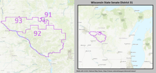
The 31st Senate District of Wisconsin is one of 33 districts in the Wisconsin State Senate. Located in western Wisconsin, the district comprises all of Buffalo, Pepin, and Trempealeau counties, and most of Pierce County, as well as western Eau Claire County, western Jackson County, and part of southern Dunn County. It includes most of the city of Eau Claire, as well as the cities of Arcadia, Buffalo City, Durand, Galesville, Independence, Prescott, and Whitehall. The district also contains landmarks such as Trempealeau National Wildlife Refuge, Perrot State Park, and University of Wisconsin–Eau Claire.
Eau Claire Dam is a dam in Eau Claire County, Wisconsin, United States.
The Red Cedar State Trail is a 14.5-mile (23.3 km) rail trail which runs along the Red Cedar River in Dunn County, Wisconsin. The trail runs north-south from Wisconsin Highway 29 in Menomonie to the Chippewa River State Trail in Red Cedar, passing through the communities of Irvington and Downsville along the way. The northern end of the trail has a visitor center in a former railroad station where trail passes can be purchased.

