Oneida is a town in Outagamie County, Wisconsin, United States. The population was 4,001 at the 2000 census. The unincorporated communities of Chicago Corners and Oneida are located in the town. The town occupies the Outagamie County portion of Wisconsin's Oneida Nation of Wisconsin.

Shiocton is a village in Outagamie County, Wisconsin, United States. The population was 921 at the 2010 census. It is wholly surrounded by the Town of Bovina.

New London is a city in Outagamie and Waupaca Counties in the U.S. state of Wisconsin. Founded in 1851, the population was 7,295 at the 2010 census. Of this, 5,685 were in Waupaca County, and 1,640 were in Outagamie County. The city has a Saint Patrick's Day Parade, Irish Fest, and week-long festivities, when the city's name is changed to "New Dublin" for the week.

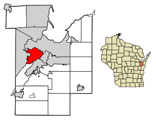
Howard is a village in Brown and Outagamie counties in the U.S. state of Wisconsin. The population was 17,399 at the 2010 census. All of this population resided in the Brown County portion of the village. It is part of the Green Bay Metropolitan Statistical Area.

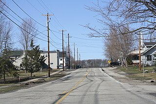
Oneida is an unincorporated community and former census-designated place (CDP) in the Town of Oneida, Outagamie County, Wisconsin, United States. The population was 1,070 at the 2000 census. At the census, part of the CDP lay within the Town of Hobart, which has since incorporated as a village, in adjacent Brown County. Oneida is located on Wisconsin Highway 54.

Black Creek is a village in north-central Outagamie County, Wisconsin, United States. The population was 1,316 at the 2010 census. The village is located within the Town of Black Creek. Origins of the community trace back to 1862 when it was settled by American Civil War veteran, Thomas J. Burdick and his son, Abraham. Initially, the village had been referred to as Middleburg, due to its geographical proximity to Green Bay, Shawano, and Appleton. However, the name was later changed to reflect the dark-colored creek along the outskirts of the community following village incorporation in 1904. Today, Black Creek hosts a variety of community events including the annual Family Daze celebration.

Black Creek is a town in Outagamie County, Wisconsin, United States. The population was 1,259 at the 2010 census. The Village of Black Creek, and the unincorporated communities of Binghamton, and partially Five Corners are located in the town.
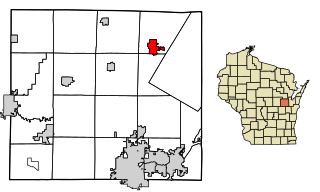
Seymour is a city in Outagamie County, Wisconsin, United States. The population was 3,451 at the 2010 census. The city is located within the Town of Seymour and the Town of Osborn.
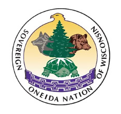
The Oneida Nation of Wisconsin is a federally recognized tribe of Oneida people, with a reservation located in parts of two counties on the west side of the Green Bay metropolitan area. The reservation was established by treaty in 1838, and was allotted to individual New York Oneida tribal members as part of an agreement with the U.S. government. The land was individually owned until the tribe was formed under the Indian Reorganization Act of 1934.

Isaar is a small unincorporated community in the Town of Seymour in Outagamie County, United States, about 10 miles from Green Bay. Isaar has the same zip code as the City of Seymour and its schools are part of the Seymour Community School District.

Center Valley is a small unincorporated farming community in the town of Center in Outagamie County, Wisconsin, United States. Center Valley lies 5 miles (8.0 km) north of the City of Appleton, and is served by the post office of Black Creek, which has the ZIP code 54106.
Sugar Bush is an unincorporated community located entirely within the town of Maple Creek in northwest Outagamie County, Wisconsin, United States. Sugar Bush is classified as a Class U6 Community by the USGS, being a populated place located wholly or substantially outside the boundaries of any incorporated place or CDP with a recognized authoritative common name.
Stephensville is a small unincorporated community located entirely within the town of Ellington in west-central Outagamie County, Wisconsin, United States. Stephensville is classified as a Class U6 Community by the USGS, being a populated place located wholly or substantially outside the boundaries of any incorporated place or CDP with a recognized authoritative common name.
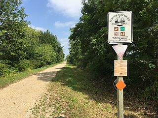
The Wiouwash State Trail is a rail trail in northeastern Wisconsin. Its named is derived from the first two letters of the four counties it traverses: Winnebago, Outagamie, Waupaca, and Shawano. The trail's Tribal Heritage Crossing of Lake Butte des Morts is a nationally designated recreation trail. The trail is used by walkers, hikers, bikers, horseback riders, and snowmobilers during the winter months. Two sections of the trail are complete: 24 miles from Aniwa south to Split Rock and 21 miles from Hortonville south to Oshkosh.
Chicago Corners is an unincorporated community in Outagamie County, Wisconsin, United States. It is located in the Town of Oneida and in the Oneida Nation of Wisconsin.
Duck Creek is a stream in Brown and Outagamie counties, Wisconsin, in the United States.