Referred to as Bodeltone in the Domesday book, the village was known as Bolton until the arrival of the railways, when the name was changed to Bolton-le-Sands to differentiate from similarly named towns on the same line, such as Bolton which was then a part of Lancashire and called Bolton-le-Moors.
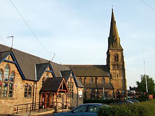
The oldest church in the village, founded prior to 1094, is the Church of England Holy Trinity church, originally dedicated to St Michael, which is grade II* listed.[3][4] The oldest part of the current building is the tower, supposed to have been built around 1500. The nave and chancel date from the 19th century. The other churches are the grade II listed Roman Catholic St Mary of the Angels[5][6] and the Christ Church United Reformed Church.[7]
The village includes three pubs: The Royal Hotel, situated on the A6, The Packet Boat (closed in 2015), and the Blue Anchor are both within the centre of the village, along the main street.
The village has one school, Bolton-le-Sands Church of England Primary School, with 320 pupils from the ages of 4 to 11 in a modern school building. It has received a 2022 Ofsted report with GOOD in all areas. The school is a successor to the old Boys' Free Grammar School, which dates from 1657, with the 19th century school building still used for community education. The school building was also home to the Bolton-le-Sands library until 1973, when the library was moved into a newly built site in the village centre.[8] The library was controversially closed in Autumn 2016 following a renovation in 2015 costing a reported £283,000.[9]
The village has a very active scout group that meets in the scout hut on the village playing fields. It has three sections; Beavers, Cubs and Scouts.[10]
Governance
An electoral ward with the same name exists. This ward stretches beyond the confines of the parish with a total population taken at the 2011 census of 4,255.[11]
Bolton is a town in Greater Manchester in England. In the foothills of the West Pennine Moors, Bolton is between Manchester, Blackburn, Wigan, Bury and Salford. It is surrounded by several towns and villages that form the wider borough, of which Bolton is the administrative centre. The town is also within the historic county boundaries of Lancashire.
Carnforth is a market town and civil parish in the City of Lancaster in Lancashire, England, situated at the north-east end of Morecambe Bay. The parish of Carnforth had a population of 5,560 in the 2011 census, an increase from the 5,350 recorded in the 2001 census. The town is situated around 7 miles north of Lancaster, 17 miles south of Kendal, 40 miles east of Barrow-in-Furness and 28 miles northwest of Settle. The town is also close to the Cumbria/Lancashire border.
Farnworth is a town in the Metropolitan Borough of Bolton, Greater Manchester, England, 2 miles (3.2 km) southeast of Bolton, 4 miles south-west of Bury (7 km), and 8 miles (12.9 km) northwest of Manchester.
Silverdale is a village and civil parish within the City of Lancaster district of Lancashire, England. The village stands on Morecambe Bay, near the border with Cumbria, 4.5 miles (7 km) north west of Carnforth and 8.5 miles (14 km) of Lancaster. The parish had a population of 1,519 recorded in the 2011 census.
Tarleton is a village and civil parish in the borough of West Lancashire, Lancashire, England. It situated in the Lancashire mosslands approximately 10 miles north east of Southport, approximately 10 miles south west of Preston, approximately 10 miles west of the town of Chorley, and approximately 10 miles north of Ormskirk. The village is known for farming due to its rich soil quality. The parish also includes the village of Mere Brow and the hamlets of Sollom and Holmes.
Blackrod is a town and civil parish in the Metropolitan Borough of Bolton, Greater Manchester,and also the Historic County of Lancashire, England, 3.9 miles (6.3 km) northeast of Wigan and 6.6 miles (10.6 km) west of Bolton. At the United Kingdom Census 2011, it had a population of 5,001.
Warton is a village, civil parish and electoral ward in the City of Lancaster in north Lancashire in the north-west of England, close to the boundary with Cumbria, with a population of around 2,000, measured at the 2011 Census to be 2,360. It is a village steeped in history; its earliest recording as a settlement is made in Domesday Book written in 1086. The nearest town to Warton is Carnforth, which was originally part of Warton parish. It has connections to the first President of the United States, George Washington: Washington's ancestor of seven generations, Lawrence Washington, is rumoured to have helped build the village church of St Oswald. The parish covers an area in excess of 11,000 acres (45 km2) and is predominantly rural. The parish of Warton had a population of 2,315 recorded in the 2001 census, and 2,360 in the 2011 census.
Halliwell is predominantly a residential area of Bolton, Greater Manchester, England. It gives its name to an electoral ward of the wider Metropolitan Borough of Bolton. The population of this ward taken at the 2011 census was 13,929. Halliwell lies about 2 miles (3.2 km) to the north west of Bolton town centre and is bounded by Tonge Moor to the east and Heaton to the south west. Smithills Hall to the north is within the ancient township. It lies on the lower south facing slopes of the West Pennine Moors.
Hambleton is a village and civil parish in the English county of Lancashire. It is situated on a coastal plain called the Fylde and in an area east of the River Wyre known locally as Over Wyre. Hambleton lies approximately 3 miles (4.8 km) north-east of its post town, Poulton-le-Fylde, and about 7 miles (11 km) north-east of the seaside resort of Blackpool. In the 2001 United Kingdom census, the parish had a population of 2,678, increasing to 2,744 at the 2011 census.
Pilling is a village and civil parish within the Wyre borough of Lancashire, England. It is 6.5 miles (10.5 km) north-northeast of Poulton-le-Fylde, 9.4 miles (15.1 km) south-southwest of Lancaster and 14.5 miles (23.3 km) northwest of Preston, in a part of the Fylde known as Over Wyre.
Claughton is a sparse village and civil parish in the county of Lancashire in the north of England, in the Borough of Wyre. The population of the civil parish at the 2011 census was 633. It is sometimes called Claughton-on-Brock to distinguish it from another Claughton in Lancashire in the Lune valley between Lancaster and Hornby.
Nether Kellet is a village and civil parish in the City of Lancaster in Lancashire, England, a few miles south of Carnforth. It had a population of 646 recorded in the 2001 census, increasing to 663 at the 2011 Census. The parish includes the small hamlet of Addington, to the east.
James Slade, (1783–1860), generally remembered as Canon Slade, was the Vicar of St Peter's Church, Bolton le Moors, Lancashire, England from 1817 to 1856.
Holy Trinity Church, Morecambe, or Morecambe Parish Church, is in Church Street, Morecambe, Lancashire, England. It is the Anglican parish church of Morecambe, in the deanery of Lancaster, the archdeaconry of Lancaster and the diocese of Blackburn. The church is recorded in the National Heritage List for England as a designated Grade II listed building.
Holy Trinity Church is an Anglican church in Blackpool, Lancashire, England. Completed in 1895, the present church replaced one from 1836. Designed by Richard Knill Freeman in the Decorated Gothic style, it has been designated a Grade II listed building by English Heritage. It is an active parish church in the Diocese of Blackburn, the archdeaconry of Lancaster and the deanery of Blackpool.
St Mary's Church is in the village of Yealand Conyers, Lancashire, England. It is an active Roman Catholic church in the diocese of Lancaster, and is linked with the churches of St Mary of the Angels, Bolton-le-Sands, and Our Lady of Lourdes, Carnforth. The church is recorded in the National Heritage List for England as a designated Grade II listed building. It stands at the south end of the village.
Holy Trinity Church, is in the village of Bolton-le-Sands, Lancashire, England. It is an active Anglican parish church in the deanery of Tunstall, the archdeaconry of Lancaster, and the diocese of Blackburn. Its benefice is united with that of St Mark, Nether Kellett. The church is recorded in the National Heritage List for England as a designated Grade II* listed building.
St Luke's Church is in Manor Lane, Slyne-with-Hest, Lancaster, Lancashire, England. It is an active Anglican parish church in the deanery of Tunstall, the archdeaconry of Lancaster, and the diocese of Blackburn. Its benefice is united with those of St Saviour, Aughton, and St Wilfrid, Halton. The church is recorded in the National Heritage List for England as a designated Grade II listed building.
Bolton-le-Sands is a civil parish in Lancaster, Lancashire, England. It contains 36 listed buildings that are recorded in the National Heritage List for England. Of these, two are listed at Grade II*, the middle grade, and the others are at Grade II. Most of the listed buildings are houses, farmhouses and cottages dating from the 17th, 18th and early 19th centuries. The Lancaster Canal passes through the parish, and five bridges crossing it are listed. The other listed buildings include two churches, two schools, two public houses, a barn, a milestone, a cross base, and a pinfold.
This page is based on this Wikipedia article Text is available under the CC BY-SA 4.0 license; additional terms may apply. Images, videos and audio are available under their respective licenses.