Bonanza, Arkansas

Last updated

Bonanza, Arkansas
Sebastian County Arkansas Incorporated and Unincorporated areas Bonanza Highlighted 0507540.svg
Location of Bonanza in Sebastian County, Arkansas.
Coordinates: 35°14′00″N94°24′59″W / 35.23333°N 94.41639°W / 35.23333; -94.41639
Country United States
State Arkansas
County Sebastian
Area
[1]
  Total2.80 sq mi (7.27 km2)
  Land2.79 sq mi (7.22 km2)
  Water0.02 sq mi (0.05 km2)
Elevation
[2]
538 ft (164 m)
Population
 (2020)
  Total587
  Density210.62/sq mi (81.32/km2)
Time zone UTC-6 (Central (CST))
  Summer (DST) UTC-5 (CDT)
ZIP code
72916
Area code 479
FIPS code 05-07540
GNIS feature ID2403891 [2]

Bonanza is a city [3] in Sebastian County, Arkansas, United States. It is part of the Fort Smith, Arkansas-Oklahoma Metropolitan Statistical Area. At the 2010 Census, the population of Bonanza was 575. According to the 2018 US Census Bureau estimates, the population of Bonanza was 564. [4] Bonanza began as a coal mining town of the Central Coal and Coke company.

Contents

History

On October 10, 1851, Sebastian County was created from parts of Crawford, Polk, and Scott County Arkansas placing Bonanza within the boundaries. Coal was discovered near the Arkansas-Oklahoma line about 12 miles southeast of Fort Smith. The Central Coal and Coke company laid tracks to the area in 1896 as part of the "St. Louis and San Francisco Railway". Bonanza sprang up as a company town. Mine #10 did not give good results but Mine #12 soon had 144 workers. Mine #20 employed 185 workers and Mine #26 employed 76 workers. The workers and their families soon reached a sizable number and C.C. Woodson filed a petition to incorporate and on November 26, 1898, the town was chartered.

Bonanza Race War

Around 200 citizens held a meeting with the purpose of removing black workers from the town. A resolution was passed “demanding that about forty negroes employed by Central Coal and Coke Company leave town.”. On April 30, 1904, there was a gun battle between black and white miners. It was reported that around 500 rounds were fired and the Arkansas Gazette reported on May 7, "nearly all black residents had left the city.". [5]

Geography

According to the United States Census Bureau, the town has a total area of 3.2 km2 (1.2 mi2), all land.

Demographics

Historical population
CensusPop.Note
1900 906
1910 811−10.5%
1920 516−36.4%
1930 406−21.3%
1940 48619.7%
1950 361−25.7%
1960 247−31.6%
1970 34238.5%
1980 55361.7%
1990 520−6.0%
2000 514−1.2%
2010 57511.9%
2020 5872.1%
U.S. Decennial Census [6]

As of the census [7] of 2000, there were 514 people, 199 households, and 151 families residing in the town. The population density was 161.3/km2 (418.7/mi2). There were 219 housing units at an average density of 68.7/km2 (178.4/mi2). The racial makeup of the town was 95.72% White, 1.17% Native American, 0.19% from other races, and 2.92% from two or more races. 1.95% of the population were Hispanic or Latino of any race.

There were 199 households, out of which 26.6% had children under the age of 18 living with them, 59.8% were married couples living together, 8.5% had a female householder with no husband present, and 24.1% were non-families. 20.6% of all households were made up of individuals, and 9.0% had someone living alone who was 65 years of age or older. The average household size was 2.58 and the average family size was 2.96.

In the town the population was spread out, with 23.7% under the age of 18, 8.4% from 18 to 24, 25.3% from 25 to 44, 28.6% from 45 to 64, and 14.0% who were 65 years of age or older. The median age was 40 years. For every 100 females, there were 113.3 males. For every 100 females age 18 and over, there were 107.4 males.

The median income for a household in the town was $30,809, and the median income for a family was $37,344. Males had a median income of $30,368 versus $17,500 for females. The per capita income for the town was $13,407. About 6.7% of families and 7.8% of the population were below the poverty line, including 9.2% of those under age 18 and 11.5% of those age 65 or over.

Education

Almost all of the town is in the Hackett Public Schools. A small piece of land is in the Greenwood School District. [8] The sole comprehensive high school of the Hackett district is Hackett High School.

See also

Related Research Articles

<span class="mw-page-title-main">Sebastian County, Arkansas</span> County in Arkansas, United States

Sebastian County is a county located in the U.S. state of Arkansas. As of the 2020 census, the population was 127,799, making it the fourth-most populous county in Arkansas. The county has two county seats, Greenwood and Fort Smith.

<span class="mw-page-title-main">Big Flat, Arkansas</span> Town in Arkansas, United States

Big Flat is a town in Baxter and Searcy counties in the U.S. state of Arkansas. The population was 88 at the 2020 census.

<span class="mw-page-title-main">Briarcliff, Arkansas</span> City in Arkansas, United States

Briarcliff is a second-class city in Baxter County, Arkansas, United States. The population was 236 at the 2010 census.

<span class="mw-page-title-main">Chester, Arkansas</span> Town in Arkansas, United States

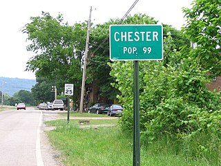
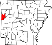
Chester is a town in Crawford County, Arkansas, United States. It is part of the Fort Smith, Arkansas-Oklahoma Metropolitan Statistical Area. As of the 2020 Census the population was 144.

<span class="mw-page-title-main">Dyer, Arkansas</span> City in Arkansas, United States

Dyer is a city in Crawford County, Arkansas, United States. It is part of the Fort Smith, Arkansas-Oklahoma Metropolitan Statistical Area. The population was 876 at the 2010 census.

<span class="mw-page-title-main">Rudy, Arkansas</span> Town in Arkansas, United States

Rudy is a town in Crawford County, Arkansas, United States. It is part of the Fort Smith, Arkansas-Oklahoma Metropolitan Statistical Area. As of the 2020 Census the population was 130. The population was 72 at the 2000 census.

<span class="mw-page-title-main">Denning, Arkansas</span> Town in Arkansas, United States

Denning is a town in Franklin County, Arkansas, United States. It is part of the Fort Smith, Arkansas-Oklahoma Metropolitan Statistical Area. The population was 314 at the 2010 census, up from 270 at the 2000 census.

<span class="mw-page-title-main">Grubbs, Arkansas</span> City in Arkansas, United States

Grubbs is a city in Jackson County, Arkansas, United States. The population was 386 at the 2010 census.

<span class="mw-page-title-main">Hindsville, Arkansas</span> Town in Arkansas, United States

Hindsville is a town in Madison County, Arkansas, United States. The population was 90 at the 2020 census. It is part of the Northwest Arkansas region.

<span class="mw-page-title-main">Cale, Arkansas</span> Town in Arkansas, United States

Cale is a town in Nevada County, Arkansas, United States. The population was 75 at the 2000 census. It is part of the Hope Micropolitan Statistical Area.

<span class="mw-page-title-main">Rosston, Arkansas</span> Town in Arkansas, United States

Rosston is a town in south-central Nevada County, Arkansas, United States. The population was 265 at the 2000 census. It is part of the Hope Micropolitan Statistical Area.

<span class="mw-page-title-main">Casa, Arkansas</span> Town in Arkansas, United States

Casa is a town in Perry County, Arkansas, United States. Located in Central Arkansas, the town initially grew due to the mining of coal, harvesting of timber and cultivation of cotton. The Great Depression reduced the population greatly, and the community's economy never recovered. The population was 171 at the 2010 census.

<span class="mw-page-title-main">Central City, Arkansas</span> City in Arkansas, United States

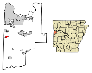
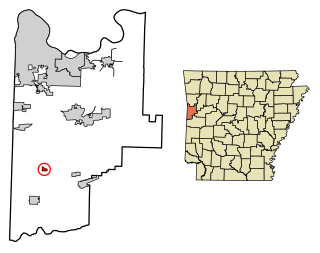
Central City is a city in Sebastian County, Arkansas, United States. It is part of the Fort Smith, Arkansas-Oklahoma Metropolitan Statistical Area. At the 2010 Census, the population of Central City was 502. According to the 2018 US Census Bureau estimates, Central City had a population of 497.

<span class="mw-page-title-main">Hackett, Arkansas</span> City in Arkansas, United States

Hackett is a city in Sebastian County, Arkansas, United States. It is part of the Fort Smith, Arkansas-Oklahoma Metropolitan Statistical Area. The population was 812 at the 2010 census.

<span class="mw-page-title-main">Hartford, Arkansas</span> City in Arkansas, United States

Hartford is a city in Sebastian County, Arkansas, United States. It is part of the Fort Smith, Arkansas-Oklahoma Metropolitan Statistical Area. The population was 642 at the 2010 census.

<span class="mw-page-title-main">Huntington, Arkansas</span> City in Sebastian County, Arkansas, United States

Huntington is a city in Sebastian County, Arkansas, United States. It is part of the Fort Smith, Arkansas-Oklahoma Metropolitan Statistical Area. As of the 2010 Census the population was 635.

<span class="mw-page-title-main">Midland, Arkansas</span> Town in Sebastian County, Arkansas, United States

Midland is a town in Sebastian County, Arkansas, United States. It is part of the Fort Smith, Arkansas-Oklahoma Metropolitan Statistical Area. The population was 325 at the 2010 census.

<span class="mw-page-title-main">Caldwell, Arkansas</span> Town in Arkansas, United States

Caldwell is a town in St. Francis County, Arkansas, United States. The population was 555 at the 2010 census, an increase from 465 in 2000.

<span class="mw-page-title-main">Goshen, Arkansas</span> City in Arkansas, United States

Goshen is a city in Washington County, Arkansas, United States. The population was 2,102 at the 2020 census. It is part of the Northwest Arkansas region. According to Business Insider, it is the “most educated” city in the state of Arkansas.

<span class="mw-page-title-main">Howe, Oklahoma</span> Town in Oklahoma, United States

Howe is a town in Le Flore County, Oklahoma, United States. It is part of the Fort Smith, Arkansas-Oklahoma Metropolitan Statistical Area. The population was 802 at the 2010 census, a gain of 15.1 percent over the figure of 697 recorded in 2000. The town was once noted for producing coal and coke, but today is chiefly supported by agriculture.

References

  1. "2020 U.S. Gazetteer Files". United States Census Bureau. Retrieved October 29, 2021.
  2. 1 2 U.S. Geological Survey Geographic Names Information System: Bonanza, Arkansas
  3. Local.Arkansas.gov - Bonanza , retrieved September 3, 2012
  4. "Population and Housing Unit Estimates" . Retrieved March 14, 2020.
  5. Lancaster, Guy (April 2010). "The Bonanza Race War of 1904". Journal of the Fort Smith Historical Society 34. Retrieved January 16, 2015.
  6. "Census of Population and Housing". Census.gov. Retrieved June 4, 2015.
  7. "U.S. Census website". United States Census Bureau . Retrieved January 31, 2008.
  8. "2020 CENSUS - SCHOOL DISTRICT REFERENCE MAP: Sebastian County, AR" (PDF). U.S. Census Bureau . Retrieved September 19, 2022.

Commons-logo.svg Media related to Bonanza, Arkansas at Wikimedia Commons