Canada has a vast geography that occupies much of the continent of North America, sharing a land border with the contiguous United States to the south and the U.S. state of Alaska to the northwest. Canada stretches from the Atlantic Ocean in the east to the Pacific Ocean in the west; to the north lies the Arctic Ocean. Greenland is to the northeast with a shared border on Hans Island. To the southeast Canada shares a maritime boundary with France's overseas collectivity of Saint Pierre and Miquelon, the last vestige of New France. By total area, Canada is the second-largest country in the world, after Russia. By land area alone, however, Canada ranks fourth, the difference being due to it having the world's largest proportion of fresh water lakes. Of Canada's thirteen provinces and territories, only two are landlocked while the other eleven all directly border one of three oceans.

The Northwest Territories is a federal territory of Canada. At a land area of approximately 1,144,000 km2 (442,000 sq mi) and a 2016 census population of 41,790, it is the second-largest and the most populous of the three territories in Northern Canada. Its estimated population as of 2023 is 45,668. Yellowknife is the capital, most populous community, and only city in the territory; its population was 19,569 as of the 2016 census. It became the territorial capital in 1967, following recommendations by the Carrothers Commission.

Northern Canada, colloquially the North or the Territories, is the vast northernmost region of Canada, variously defined by geography and politics. Politically, the term refers to the three territories of Canada: Yukon, Northwest Territories and Nunavut. This area covers about 48 per cent of Canada's total land area, but has less than 0.5 per cent of Canada's population.

The foreign relations of Canada are Canada's relations with other governments and nations. Canada is recognized as a middle power for its role in international affairs with a tendency to pursue multilateral and international solutions. Canada's foreign policy based on international peacekeeping and security is carried out through coalitions, international organizations, and the work of numerous federal institutions. Canada is often called upon to serve as a mediator in international conflicts. The strategy of the Canadian government's foreign aid policy reflects an emphasis to meet the Sustainable Development Goals, while also providing assistance in response to foreign humanitarian crises. The Canadian Security Intelligence Service (CSIS) is tasked with gathering and analyzing intelligence to prevent threats such as terrorism, espionage, and foreign interference, while the Communications Security Establishment (CSE) is focused on cyber security and protecting Canada's digital infrastructure.
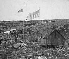
Hans Island is an island in the centre of the Kennedy Channel of Nares Strait in the high Arctic region, split between the Canadian territory of Nunavut and the Danish autonomous territory of Greenland. The island itself is barren and uninhabited with an area of 130 hectares, measuring 1,290 by 1,199 metres, and a maximum elevation of 168.17 m (551.7 ft). Its location in the strait that separates Ellesmere Island of Canada from northern Greenland was for years a border dispute, the so-called Whisky War between the two countries of Canada and Denmark. Hans Island is the smallest of three islands in Kennedy Channel off the Washington Land coast; the others are Franklin Island and Crozier Island. The strait at this point is 35 km (22 mi) wide, placing the island within the territorial waters of both Canada and Denmark (Greenland). A 1,280-metre-long (4,200 ft) shared border traverses the island.

The Beaufort Sea is a marginal sea of the Arctic Ocean, located north of the Northwest Territories, Yukon, and Alaska, and west of the Canadian Arctic Archipelago. The sea is named after Sir Francis Beaufort, a hydrographer. The Mackenzie River, the longest in Canada, empties into the Canadian part of the Beaufort Sea west of Tuktoyaktuk, which is one of the few permanent settlements on the sea's shores.

Territorial waters are informally an area of water where a sovereign state has jurisdiction, including internal waters, the territorial sea, the contiguous zone, the exclusive economic zone, and potentially the extended continental shelf. In a narrower sense, the term is often used as a synonym for the territorial sea.

An exclusive economic zone (EEZ), as prescribed by the 1982 United Nations Convention on the Law of the Sea, is an area of the sea in which a sovereign state has exclusive rights regarding the exploration and use of marine resources, including energy production from water and wind.

The Embassy of Canada in Washington, D.C. is Canada's main diplomatic mission to the United States. The embassy building designed by Arthur Erickson and opened in 1989 is located at 501 Pennsylvania Avenue Northwest, Washington, D.C., between the United States Capitol and the White House, just north of the National Gallery of Art. In addition to its diplomatic role, the embassy provides consular services for Delaware, Washington, D.C., Maryland, Virginia, and West Virginia. It also hosts a Trade Commissioner Service office responsible for the states of Maryland, Washington, D.C., Virginia, and West Virginia.

Nunavut is the largest and northernmost territory of Canada. It was separated officially from the Northwest Territories on April 1, 1999, via the Nunavut Act and the Nunavut Land Claims Agreement Act, which provided this territory to the Inuit for independent government. The boundaries had been drawn in 1993. The creation of Nunavut resulted in the first major change to Canada's political map in half a century since the province of Newfoundland was admitted in 1949.
The United States has land borders with only Canada and Mexico, both of them long. It has maritime boundaries with many countries due to its extensive exclusive economic zone (EEZ). All of its maritime borders with Canada are at least partially disputed, and its territorial claims on three Caribbean islands are disputed.

Wrangel Island is an island of the Chukotka Autonomous Okrug, Russia. It is the 92nd largest island in the world and roughly the size of Crete. Located in the Arctic Ocean between the Chukchi Sea and East Siberian Sea, the island lies astride the 180th meridian. The International Date Line is therefore displaced eastwards at this latitude to keep the island, as well as the Chukchi Peninsula on the Russian mainland, on the same day as the rest of Russia. The closest land to Wrangel Island is the tiny and rocky Herald Island located 60 kilometres to the east. Its straddling the 180th meridian makes its north shore at that point both the northeasternmost and northwesternmost point of land in the world by strict longitude; using the International Date Line instead those respective points become Herald Island and Alaska's Cape Lisburne.
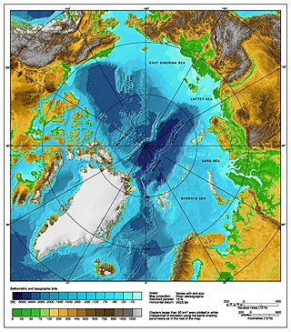
The Arctic consists of land, internal waters, territorial seas, exclusive economic zones (EEZs) and international waters above the Arctic Circle. All land, internal waters, territorial seas and EEZs in the Arctic are under the jurisdiction of one of the eight Arctic coastal states: Canada, Denmark, Finland, Iceland, Norway, Russia, Sweden and the United States. International law regulates this area as with other portions of Earth.

Arctic cooperation and politics are partially coordinated via the Arctic Council, composed of the eight Arctic nations: the United States, Canada, Iceland, Norway, Sweden, Finland, Russia, and Denmark with Greenland and the Faroe Islands. The dominant governmental power in Arctic policy resides within the executive offices, legislative bodies, and implementing agencies of the eight Arctic nations, and to a lesser extent other nations, such as United Kingdom, Germany, European Union and China. NGOs and academia play a large part in Arctic policy. Also important are intergovernmental bodies such as the United Nations and NATO.

The Arctic Policy of the Kingdom of Denmark defines the Kingdom's foreign relations and policies with other Arctic countries, and the Kingdom's strategy for the Arctic on issues occurring within the geographic boundaries of "the Arctic" or related to the Arctic or its peoples. In order to clearly understand the Danish geopolitical importance of the Arctic, it is necessary to mention Denmark's territorial claims in areas beyond its exclusive EEZ in areas around the Faroe Islands and north of Greenland covering parts of the North Pole, which is also claimed by Russia.

The Whisky War, also known as the Liquor Wars, was a bloodless war and border dispute between the Kingdom of Denmark and Canada over Hans Island. Between 1973 and 2022, the island was under dispute between the two nations, although never amounting to direct conflict or violence.

The Arctic Five are the five littoral states bordering the Arctic Ocean: Canada, The Kingdom of Denmark, Norway, The Russia Federation and the United States of America.