Borders of the United States

Last updated

The United States has land borders with only Canada and Mexico, both of them long. Its has maritime boundaries with many countries due to its extensive exclusive economic zone (EEZ). All of its maritime borders with Canada are at least partially disputed, and its territorial claims on three Caribbean islands are disputed.

Contents

List

Exclusive economic zone maritime boundaries in the Caribbean Sea and equatorial Atlantic Ocean Map of the Territorial Waters in the Caribbean.png
Exclusive economic zone maritime boundaries in the Caribbean Sea and equatorial Atlantic Ocean
EEZ maritime boundaries in the Pacific Ocean Map of the Exclusive Economic Zones of the Pacific Ocean.png
EEZ maritime boundaries in the Pacific Ocean

Maritime borders that are not delineated by bilateral treaty are defined by United States acceptance of the United Nations Convention on the Law of the Sea (UNCLOS), which includes the convention's exclusive economic zone boundary definitions but does not extend to mineral rights in international waters. United States Minor Outlying Islands (USMOI) are mostly uninhabited, unorganized, and unincorporated.

Part of the United StatesForeign entityTypeNotes
Contiguous United States Mexico Land, near-shore, and EEZ Mexico–United States border, including Pacific Ocean and Gulf of Mexico. Land boundaries defined by the 1819 Adams–Onís Treaty (with Spain), 1828 Treaty of Limits, 1848 Treaty of Guadalupe Hidalgo, 1854 Gadsden Purchase, and Boundary Treaty of 1970. Ocean boundaries defined by bilateral treaties in 1970, 1978, and 2001. [1]
Contiguous United States Canada Land, near-shore, and EEZ Canada–United States border - Partially disputed in the Atlantic Ocean (Maine-New Brunswick) and Pacific Ocean (Washington State-British Columbia). Passamaquoddy Bay border defined by 1910 treaty. Gulf of Maine partial border defined by 1984 ruling of the International Court of Justice. [1] Land and Great Lakes border defined by the 1783 Treaty of Paris, 1794 Jay Treaty, Treaty of 1818, 1842 Webster–Ashburton Treaty and 1846 Oregon Treaty (all with the United Kingdom).
Alaska Canada Land, near-shore, and EEZ Canada–United States border - disputed in the Arctic Ocean (Yukon) and Pacific Ocean (British Columbia). [1] Land border defined by Anglo-Russian Convention of 1825, and 1903 Hay–Herbert Treaty (with the United Kingdom).
Alaska Russia EEZThe de facto boundary between the United States and Russia is defined by the USSR–USA Maritime Boundary Agreement, negotiated with the Soviet Union in 1990, [1] covering the Bering Sea, Bering Strait, and Arctic Ocean. The agreement was never ratified by the Soviet Union before it dissolved, and it has never been ratified by the Russian State Duma. It has been ratified by the United States Senate, respected in practices by both governments, and defended against encroachment by fishing vessels. The boundary line generally follows the line agreed to during the 1867 Alaska Purchase, though this could not be entirely determined because neither country could produce maps agreed to at that time.
Contiguous United States Bahamas EEZ, Atlantic Ocean UNCLOS [1]
Contiguous United States Cuba EEZ, Gulf of Mexico 1977 Cuba–United States Maritime Boundary Agreement [1]
Puerto Rico and United States Virgin Islands Dominican Republic, British Virgin Islands and Anguilla (dependencies of the United Kingdom), Sint Maarten (dependency of the Netherlands), Venezuela EEZ, Caribbean Sea 1993 United Kingdom–United States Maritime Boundary Treaties, 1980 United States–Venezuela Maritime Boundary Treaty, others UNCLOS [1]
Northern Mariana Islands Japan (Volcano Islands)EEZ, Pacific Ocean UNCLOS [1]
Guam Federated States of Micronesia (freely associated state)EEZ, Pacific Ocean Defined by 2019 treaty. [1]
American Samoa Tonga, Samoa, and New Zealand dependencies: Cook Islands, Niue, and Tokelau EEZ, Pacific Ocean Cook Islands and Tokelau borders defined by three treaties in 1980, 1980, and 1997, respectively; others UNCLOS [1]
Baker Island and Howland Island, Johnston Atoll and Kingman Reef, and Jarvis Island (USMOI) Kiribati (three discontinuous extents)EEZ, Pacific Ocean Defined by 2019 treaty. [1]
Wake Island (disputed USMOI) Marshall Islands (freely associated state)EEZ, Pacific Ocean Claimed by Marshall Islands, administered by the United States
Bajo Nuevo Bank and Serranilla Bank (disputed USMOI) Colombia, Jamaica, Honduras, Nicaragua EEZ, Caribbean Sea Claimed by Colombia (other neighbors recognize Colombian claim [2] )
Navassa Island (disputed USMOI) Jamaica, Haiti, Cuba EEZ, Caribbean Sea Claimed by Haiti

Custom territories

Insular areas in the Pacific and the U.S. Virgin Islands are not included in the main domestic customs territory which is limited to the 50 states, the District of Columbia, and Puerto Rico.

Border disputes

Disputed occupation

The United States administers Guantanamo Bay Naval Base on what both countries agree is the sovereign territory of Cuba under a permanent lease obtained under the Cuban–American Treaty of Relations (1903), while Cuba was under American military occupation after the 1898 Spanish–American War. After the Cuban Revolution in the 1950s, Cuba disputed the validity of this lease and ceased cooperating with the base. The boundary is highly militarized, but the United States has maintained control without active fighting.

Enforcement

Three agencies in the federal Department of Homeland Security split border-related responsibilities. U.S. Customs and Border Protection staffs official border checkpoints, collects tariff duties, and inspects arriving people, and inspects goods being imported by land, sea, and air. U.S. Immigration and Customs Enforcement polices borders away from official points of entry. United States Citizenship and Immigration Services administers immigration procedures.

The United States Coast Guard actively patrols the nation's extensive maritime borders, acting as a law enforcement agency in peacetime. The United States Armed Forces are generally prohibited from domestic law enforcement (including arresting smugglers and illegal immigrants) under the Posse Comitatus Act, but can be activated to secure the border in an emergency or respond to an attack. State and federal National Guard troops and even active-duty military personnel have been used in support roles at the border, which has been controversial and limited by legal complexities. [6] [7]

The border search exception to the guarantees in the Fourth Amendment to the United States Constitution against unreasonable search and seizure and requirement for search warrants apply to border checkpoints and areas within 100 miles (160 km) of the border.

See also

Related Research Articles

<span class="mw-page-title-main">Navassa Island</span> Caribbean island administered by the United States, claimed by Haiti

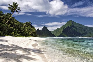
Navassa Island is a small uninhabited island in the Caribbean Sea. Located northeast of Jamaica, south of Cuba, and 40 nautical miles west of Jérémie on the Tiburon Peninsula of Haiti, it is subject to an ongoing territorial dispute between Haiti and the United States, which administers the island through the U.S. Fish and Wildlife Service.

<span class="mw-page-title-main">United States Minor Outlying Islands</span> Statistical designation of small islands of the United States

The United States Minor Outlying Islands is a statistical designation defined by the International Organization for Standardization's ISO 3166-1 code. The entry code is ISO 3166-2:UM. The minor outlying islands and groups of islands consist of eight United States insular areas in the Pacific Ocean and one in the Caribbean Sea.

<span class="mw-page-title-main">Aroostook War</span> 1838-39 border dispute between the British colony of New Brunswick and the U.S. state of Maine

The Aroostook War, or the Madawaska War, was a military and civilian-involved confrontation in 1838–1839 between the United States and the United Kingdom over the international boundary between the British colony of New Brunswick and the U.S. state of Maine. The term "war" was rhetorical; local militia units were called out but never engaged in actual combat. The event is best described as an international incident.

In the United States, a territory is any extent of region under the sovereign jurisdiction of the federal government of the United States, including all waters. The United States asserts sovereign rights for exploring, exploiting, conserving, and managing its territory. This extent of territory is all the area belonging to, and under the dominion of, the United States federal government for administrative and other purposes. The United States total territory includes a subset of political divisions.

<span class="mw-page-title-main">Insular area</span> U.S. territory that is neither a U.S. state nor the District of Columbia

In the law of the United States, an insular area is a U.S.-associated jurisdiction that is not part of the several states or the District of Columbia. This includes fourteen U.S. territories administered under U.S. sovereignty, as well as three sovereign states each with a Compact of Free Association with the United States. The term also may be used to refer to the previous status of the Swan Islands, Hawaii, Puerto Rico, and the Philippines, as well as the Trust Territory of the Pacific Islands when it existed.

<span class="mw-page-title-main">Territories of the United States</span> Overview of historical and current U.S. territories

Territories of the United States are sub-national administrative divisions overseen by the federal government of the United States. The various American territories differ from the U.S. states and Indian reservations as they are not sovereign entities. In contrast, each state has a sovereignty separate from that of the federal government and each federally recognized Native American tribe possesses limited tribal sovereignty as a "dependent sovereign nation." Territories are classified by incorporation and whether they have an "organized" government through an organic act passed by the Congress. American territories are under American sovereignty and, consequently, may be treated as part of the United States proper in some ways and not others. Unincorporated territories in particular are not considered to be integral parts of the United States, and the Constitution of the United States applies only partially in those territories.

<span class="mw-page-title-main">Canada–United States border</span> International border

The Canada–United States border is the longest international border in the world. The boundary is 8,891 km (5,525 mi) long. The land border has two sections: Canada's border with the contiguous United States to its south, and with the U.S. state of Alaska to its west. The bi-national International Boundary Commission deals with matters relating to marking and maintaining the boundary, and the International Joint Commission deals with issues concerning boundary waters. The agencies responsible for facilitating legal passage through the international boundary are the Canada Border Services Agency (CBSA) and U.S. Customs and Border Protection (CBP).

<span class="mw-page-title-main">Machias Seal Island</span> Disputed island in the Gulf of Maine

Machias Seal Island is an island in disputed water between the Gulf of Maine and the Bay of Fundy, about 16 km (10 mi) southeast from Cutler, Maine, and 19 km (12 mi) southwest of Grand Manan Island, New Brunswick. Sovereignty of the island is disputed by the United States and Canada. The Canadian Coast Guard continues to staff a lighthouse on the island; the first lighthouse was constructed there in 1832.

<span class="mw-page-title-main">Serranilla Bank</span> Colombian-controlled uninhabited reef in the western Caribbean Sea

Serranilla Bank is a partially submerged reef, with small uninhabited islets, in the western Caribbean Sea. It is situated about 350 kilometres (220 mi) northeast of Punta Gorda, Nicaragua, and roughly 280 kilometres (170 mi) southwest of Jamaica. The closest neighbouring land feature is Bajo Nuevo Bank, located 110 kilometres (68 mi) to the east.

<span class="mw-page-title-main">Bajo Nuevo Bank</span> Colombia-controlled uninhabited reef in the western Caribbean Sea

Bajo Nuevo Bank, also known as the Petrel Islands, is a small, uninhabited reef with some small grass-covered islets, located in the western Caribbean Sea at 15°53′N78°38′W, with a lighthouse on Low Cay at 15°51′N78°38′W. The closest neighbouring land feature is Serranilla Bank, located 110 kilometres to the west.

<span class="mw-page-title-main">Exclusive economic zone</span> Adjacent sea zone in which a state has special rights

An exclusive economic zone (EEZ), as prescribed by the 1982 United Nations Convention on the Law of the Sea, is an area of the sea in which a sovereign state has exclusive rights regarding the exploration and use of marine resources, including energy production from water and wind. EEZ does not define the ownership of any maritime features within the EEZ.

<span class="mw-page-title-main">Dixon Entrance</span> Strait on the western Canada–United States border

The Dixon Entrance is a strait about 80 kilometers (50 mi) long and wide in the Pacific Ocean at the Canada–United States border, between the U.S. state of Alaska and the province of British Columbia in Canada. The Dixon Entrance is part of the Inside Passage shipping route. It forms part of the maritime boundary between the U.S. and Canada, although the location of that boundary here is disputed.

<span class="mw-page-title-main">Territorial evolution of the United States</span> Changes and expansion of the territory of the United States

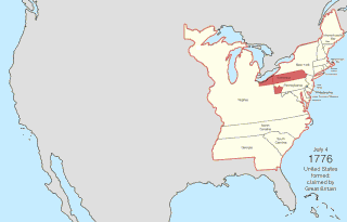
The United States of America was formed after thirteen British colonies in North America declared independence from the British Empire on July 4, 1776. In the Lee Resolution, passed by the Second Continental Congress two days prior, the colonies resolved that they were free and independent states. The union was formalized in the Articles of Confederation, which came into force on March 1, 1781, after being ratified by all 13 states. Their independence was recognized by Great Britain in the Treaty of Paris of 1783, which concluded the American Revolutionary War. This effectively doubled the size of the colonies, now able to stretch west past the Proclamation Line to the Mississippi River. This land was organized into territories and then states, though there remained some conflict with the sea-to-sea grants claimed by some of the original colonies. In time, these grants were ceded to the federal government.

The United States Miscellaneous Caribbean Islands is an obsolete collective term for the territories currently or formerly controlled by the United States in the Caribbean Sea. Most of the islands were acquired through claims made via the Guano Islands Act:

Territorial disputes of Nicaragua include the territorial dispute with Colombia over the Archipelago of San Andrés, Providencia and Santa Catalina and Quita Sueño Bank. Nicaragua also has a maritime boundary dispute with Honduras in the Caribbean Sea and a boundary dispute over the Rio San Juan with Costa Rica.

<span class="mw-page-title-main">Territorial evolution of North America since 1763</span> Timeline of notable events

The 1763 Treaty of Paris ended the major war known by Americans as the French and Indian War and by Canadians as the Seven Years' War / Guerre de Sept Ans, or by French-Canadians, La Guerre de la Conquête. It was signed by Great Britain, France and Spain, with Portugal in agreement. Preferring to keep Guadeloupe, France gave up Canada and all of its claims to territory east of the Mississippi River to Britain. With France out of North America this dramatically changed the European political scene on the continent.

The United States has the world's second largest exclusive economic zone. The total size is 11,351,000 km2 (4,383,000 sq mi)2. Areas of its EEZ are located in three oceans, the Gulf of Mexico, and the Caribbean Sea. Most notable areas are Alaska, Hawaii, the East Coast, West Coast and Gulf Coast of the United States.

References

  1. 1 2 3 4 5 6 7 8 9 10 11 "U.S. Maritime Boundaries: Agreements and Treaties". Office of Ocean and Polar Affairs, United States Department of State . Retrieved February 3, 2024.
  2. 1 2 "Bajo Nueva Bank – De Facto". defactoborders.org. Retrieved October 6, 2020.
  3. "Delimitation of the Maritime Boundary in the Gulf of Maine Area (Canada/United States of America)". International Court of Justice.
  4. Robin Matthewman (April 28, 2021). "Mark B. Feldman [Interview]" (PDF). Association for Diplomatic Studies and Training, Foreign Oral History Collection.
  5. Treaty Between the United States of America and New Zealand on the Delimitation of the Maritime Boundary Between Tokelau and the United States of America
  6. Ryan Burke (May 10, 2023). "Active Duty Military Forces Are Heading to the Border: What Can They Legally Do There?". United States Military Academy.
  7. Diana Roy; Amelia Cheatham; Claire Klobucista (July 26, 2023). "How the U.S. Patrols Its Borders". Council on Foreign Relations.