Bradley Township, Jackson County, Illinois

Last updated

Bradley Township
Map highlighting Bradley Township, Jackson County, Illinois.svg
Location in Jackson County
Map of Illinois highlighting Jackson County.svg
Jackson County's location in Illinois
Coordinates: 37°54′39″N89°32′39″W / 37.91083°N 89.54417°W / 37.91083; -89.54417
Country United States
State Illinois
County Jackson
EstablishedNovember 4, 1884
Area
  Total45 sq mi (120 km2)
  Land44.94 sq mi (116.4 km2)
  Water0.06 sq mi (0.2 km2)  0.13%
Elevation
614 ft (187 m)
Population
 (2010)
  Estimate 
(2016) [1]
1,879
  Density43.4/sq mi (16.8/km2)
Time zone UTC-6 (CST)
  Summer (DST) UTC-5 (CDT)
ZIP codes
62280, 62907, 62916
FIPS code 17-077-07731

Bradley Township is one of sixteen townships in Jackson County, Illinois, USA. At the 2010 census, its population was 1,951 and it contained 821 housing units. [2]

Contents

Geography

According to the 2010 census, the township has a total area of 45 square miles (120 km2), of which 44.94 square miles (116.4 km2) (or 99.87%) is land and 0.06 square miles (0.16 km2) (or 0.13%) is water. [2]

Location grid


Geographical features

Natural

Degognia Creek is the western line of demarcation. Kinkaid and Beaucoup Creeks have their source within its limits, the former flowing southward and the latter in a northeasterly direction. It is further drained and watered by Degognia Creek and some of its eastern tributaries.

Manmade

The St. Louis and Cairo Railroad enters it from the north and runs a south-easterly course, leaving in the east, a little more than one mile (1.6 km) from the south line.

History

Bradley Township lies in the extreme north-western part of Jackson County and was named in honor of Judge William Bradley who had migrated to the county with his father Joshua Bradley from Tennessee.[ citation needed ] The township contained a few settlers before the organization of the State in 1818. It contains two towns, Campbell Hill on the railroad named above, 4 miles (6.4 km) from its rival, Ava.

This village of Bradley was surveyed and laid out by Edward Newsome, county surveyor, and certified on January 10, 1874. The plat was filed for record with R.W. Hamilton, Circuit Clerk and Recorder, two months later on 19 March. A somewhat prospective but nonetheless partly critical historic description reads "St. Louis & C. R. R. has a station here, and Bradley is deserted, and its glory has paled in the presence of the more youthful competitor."[ citation needed ]" The source goes on to say that the township had one school building built in 1877, at the considerable cost to the taxpayers of about $1,200, with architectural expertise as well as taste and culture.[ citation needed ]

In its early days it boasted one hotel kept by Mr. Benson, and its reputation may be inferred from the fact that it was to his hotel the passengers northward or southward on the railroad turned for their dinners. One church was built in the town, erected by the Baptist society, known as "Looney Spring" Church. Judge Bradley and his brother Richard Bradley had both been pastors of this church along with George Gordon. This is the strongest religious organization in that part of the county. Among the members of this church, in its early years, mention is made of David Underwood, his sons and families, the Gordons, the Phoenix, and Downen families. A prosperous Sunday School was connected with the church.

Gordon & Co. were dealers in general merchandise. Augustus Dudenbastle was postmaster and dealer in dry goods and groceries. John Hanna had a drug store, the custom and merchant mill, which was formerly run by Thomas Woods and William Mohlenbrock, "a large and well-conducted establishment, and afford[ed] the farmers a home market for their grain".[ citation needed ]

Among the substantial farmers of Bradley Township, or as it was then called, Bradley precinct, were Cyrus Bradley, Jonathan McDonald, William Downen, Peter Stuffle and certain Messrs. Phoenix, Tucker, Ward and Underwood. Among the first settlers were Mrs. William Kimmel in 1817 and Mr Barrow. Josiah Cully came to settle in the Bradley settlement in 1836. A very considerable portion of this township consists of land suitable for agricultural purposes, and it is still a heavily agricultural community to this day. In the eastern part, the land is somewhat broken, but of good quality; in the south and west the surface is smooth. Some exceedingly well-tilled farms are found in this section and the traveler through Bradley meets evidence of thrift and plenty on every hand. The people are honest and wide-awake, and are marching abreast of the times. The old log school-houses have largely disappeared, and new frame buildings, comfortably seated and well lighted, are superseding them.[ citation needed ]

The historic account continues "this was all heavily timbered before 'his echoing axe, the settler swung', and there is yet an abundance of the very best timber. Good qualities of building stone abound."[ citation needed ]

Cities, towns, villages

Unincorporated towns

(This list is based on USGS data and may include former settlements.)

Extinct towns

(These towns are listed as "historical" by the USGS.)

Adjacent townships

Cemeteries

The township contains eleven cemeteries: Barrow, Calvary, Cheatham, Evergreen, Koehn, Kross, Looney Springs, Modglin, Rogers, Saint Lukes and Saint Peters.

Major highways

Demographics

Historical population
CensusPop.Note
2016 (est.)1,879 [1]
U.S. Decennial Census [3]

School districts

Political districts

Related Research Articles

<span class="mw-page-title-main">Perry County, Illinois</span> County in Illinois, United States

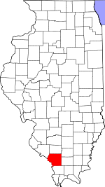
Perry County is in Illinois. According to the 2020 census, it had a population of 20,945. Its county seat is Pinckneyville. It is located in the southern portion of Illinois known as "Little Egypt".

<span class="mw-page-title-main">Manteno, Illinois</span> Village in Illinois, United States

Manteno is a village in Kankakee County, Illinois, United States. The population was 9,210 at the 2020 census. It is part of the Kankakee-Bourbonnais-Bradley Metropolitan Statistical Area.

<span class="mw-page-title-main">Maroa, Illinois</span> City in Illinois, United States

Maroa is a city in Macon County, Illinois, United States. Its population was 1,577 at the 2020 census, down from 1,801 in 2010. It is included in the Decatur, Illinois Metropolitan Statistical Area.

<span class="mw-page-title-main">Augusta Charter Township, Michigan</span> Charter township in Michigan, United States

Augusta Charter Township is a charter township of Washtenaw County in the U.S. state of Michigan. The population was 6,745 at the 2010 census.

<span class="mw-page-title-main">Peotone Township, Will County, Illinois</span> Township in Illinois, United States

Peotone Township is located in Will County, Illinois. As of the 2010 census, its population was 4,431 and it contained 1,728 housing units. Peotone was formed from the eastern half of Wilton Township at an unknown date. It has towns of Andres and Peotone. Interstate 57, Route 50, Route 45, and Route 52 are major routes.

<span class="mw-page-title-main">Washington Township, Will County, Illinois</span> Township in Illinois, United States

Washington Township is located in Will County, Illinois. As of the 2010 census, its population was 6,263 and it contained 2,404 housing units. Washington Township was formed from Crete Township and Sherburn Township on an unknown date.

<span class="mw-page-title-main">Will Township, Will County, Illinois</span> Township in Illinois, United States

Will Township is located in Will County, Illinois. As of the 2010 census, its population was 1,821 and it contained 700 housing units. Will Township was formed from the former township of Carey, which included modern day Monee Township and Will Township, in January 1859.

<span class="mw-page-title-main">Hittle Township, Tazewell County, Illinois</span> Township in Illinois, United States

Hittle Township is located in Tazewell County, Illinois. As of the 2010 census, its population was 591 and it contained 254 housing units. Hittle Township was originally called Union Township. The name was changed from Union to Waterford Township on May 20, 1850, and again from Waterford to Armington Township in August, 1850. Armington was changed to Hittle though on November 11 of that same year.

<span class="mw-page-title-main">Avoca Township, Livingston County, Illinois</span> Township in Illinois, United States

Avoca Township is located in Livingston County, Illinois. As of the 2010 census, its population was 405 and it contained 149 housing units.

<span class="mw-page-title-main">Sunbury Township, Livingston County, Illinois</span> Township in Illinois, United States

Sunbury Township is located in Livingston County, Illinois. As of the 2010 census, its population was 229 and it contained 103 housing units.

<span class="mw-page-title-main">Fancy Creek Township, Sangamon County, Illinois</span> Township in Illinois, United States

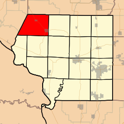
Fancy Creek Township is located in Sangamon County, Illinois. As of the 2010 census, its population was 5,410 and it contained 2,074 housing units. Fancy Creek Township changed its name from Power Township on September 11, 1861. The township annexed the eastern half of Salisbury Township in 1989, thereby increasing in size.

<span class="mw-page-title-main">Hire Township, McDonough County, Illinois</span> Township in Illinois, United States

Hire Township is located in McDonough County, Illinois. As of the 2010 census, its population was 229 and it contained 117 housing units.

<span class="mw-page-title-main">Ellisville Township, Fulton County, Illinois</span> Township in Illinois, United States

Ellisville Township is one of twenty-six townships in Fulton County, Illinois, USA. As of the 2010 census, its population was 155 and it contained 69 housing units.

<span class="mw-page-title-main">Degognia Township, Jackson County, Illinois</span> Township in Illinois, United States

Degognia Township is one of 16 townships in Jackson County, in the U.S. state of Illinois. As of the 2010 census, its population was 153 and it contained 73 housing units. The township derives its name from Degognia Creek.

<span class="mw-page-title-main">Fountain Bluff Township, Jackson County, Illinois</span> Township in Illinois, United States

Fountain Bluff Township is one of sixteen townships in Jackson County, Illinois, USA. As of the 2010 census, its population was 208 and it contained 110 housing units.

<span class="mw-page-title-main">Kinkaid Township, Jackson County, Illinois</span> Township in Illinois, United States

Kinkaid Township is one of sixteen townships in Jackson County, Illinois, USA. As of the 2010 census, its population was 486 and it contained 227 housing units.

<span class="mw-page-title-main">Levan Township, Jackson County, Illinois</span> Township in Illinois, United States

Levan Township is one of sixteen townships in Jackson County, Illinois, USA. As of the 2010 census, its population was 850 and it contained 365 housing units.

<span class="mw-page-title-main">Ora Township, Jackson County, Illinois</span> Township in Illinois, United States

Ora Township is one of sixteen townships in Jackson County, Illinois, USA. As of the 2010 census, its population was 514 and it contained 210 housing units.

<span class="mw-page-title-main">Sand Ridge Township, Jackson County, Illinois</span> Township in Illinois, United States

Sand Ridge Township is one of sixteen townships in Jackson County, Illinois, USA. As of the 2010 census, its population was 816 and it contained 354 housing units.

<span class="mw-page-title-main">Ridgway Township, Gallatin County, Illinois</span> Township in Illinois, United States

Ridgway Township is one of ten townships in Gallatin County, Illinois, USA. As of the 2010 census, its population was 937 and it contained 470 housing units.

References

  1. 1 2 "Population and Housing Unit Estimates" . Retrieved June 9, 2017.
  2. 1 2 "Population, Housing Units, Area, and Density: 2010 - County -- County Subdivision and Place -- 2010 Census Summary File 1". United States Census. Archived from the original on February 12, 2020. Retrieved May 28, 2013.
  3. "Census of Population and Housing". Census.gov. Retrieved June 4, 2016.