
Chelsea is a city in Suffolk County, Massachusetts, United States, directly across the Mystic River from Boston. At the 2020 census, Chelsea had a population of 40,787. With a total area of just 2.46 square miles, Chelsea is the smallest city in Massachusetts in terms of total area. It is the second most densely populated city in Massachusetts, behind Somerville, and is the city with the second-highest percentage of Latino residents in Massachusetts, behind Lawrence.

Downtown Pittsburgh, colloquially referred to as the Golden Triangle, and officially the Central Business District, is the urban downtown center of Pittsburgh, Pennsylvania, United States. It is located at the confluence of the Allegheny River and the Monongahela River whose joining forms the Ohio River. The triangle is bounded by the two rivers.

Chestnut Hill is a wealthy New England village located six miles (10 km) west of downtown Boston, Massachusetts, United States. Like all Massachusetts villages, Chestnut Hill is not an incorporated municipal entity. It is located partially in Brookline in Norfolk County; partially in the city of Boston in Suffolk County, and partially in the city of Newton in Middlesex County. Chestnut Hill's borders are defined by the 02467 ZIP Code. The name refers to several small hills that overlook the 135-acre Chestnut Hill Reservoir rather than one particular hill. Chestnut Hill is best known as the home of Boston College and as part of the Boston Marathon route.

Newtonville is one of the thirteen villages within the city of Newton in Middlesex County, Massachusetts, United States.

Downtown Vancouver is the central business district and the city centre neighbourhood of Vancouver, Canada, on the northwestern shore of the Burrard Peninsula in the Lower Mainland region of British Columbia. It occupies most of the north shore of the False Creek inlet, which cuts into the Burrard Peninsula creating the Downtown Peninsula, where the West End neighbourhood and Stanley Park are also located.
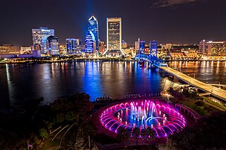
Downtown Jacksonville is the historic core and central business district (CBD) of Jacksonville, Florida. It comprises the earliest area of the city to be developed and is located in its geographic center along the narrowing point of the St. Johns River.

Neighborhoods in Spokane, Washington are officially grouped by the Spokane City Council into three main city council districts: 1, 2, and 3. Each city council district contains multiple, official neighborhoods that are recognized with a neighborhood council. Informally, neighborhoods are colloquially grouped by local geographical, geological, cultural, or historical features The list of neighborhoods below is organized based on the official designations by the City of Spokane. Unofficial neighborhoods and districts are listed within the official neighborhood in which they are located.
Columbus, the state capital and Ohio's largest city, has numerous neighborhoods within its city limits. Neighborhood names and boundaries are not officially defined. They may vary or change from time to time due to demographic and economic variables.

Louisville, Kentucky is home to numerous structures that are noteworthy due to their architectural characteristics or historic associations, the most noteworthy being the Old Louisville neighborhood, the third largest historic preservation district in the United States. The city also boasts the postmodern Humana Building and an expanding Waterfront Park which has served to remove the former industrial appearance of the riverfront.

The Salem–Auburn Streets Historic District is a residential historic district at Salem and Auburn Streets in Cambridge, Massachusetts. The district includes a collection of houses that is among the oldest in the Cambridgeport section of the city, and includes most of the houses on two blocks of these streets. The district was added to the National Register of Historic Places in 1982.
The North Bedford Historic District is a historic district roughly bounded by Summer, Parker, Pleasant and Kempton Streets in New Bedford, Massachusetts. It encompasses a predominantly residential neighborhood north of downtown New Bedford which was developed primarily in the mid 19th-century. It features a variety of worker housing of the period, as well as a number of higher quality houses built by businessmen. The district was added to the National Register of Historic Places in 1979.

The Church Street–Cady Hill Historic District, originally known as the Church Street Historic District, is a historic district in North Adams, Massachusetts. It was first listed on the National Register of Historic Places in 1983 and was expanded and renamed in 1985. The district encompasses the principal residential areas near the center of downtown. When first designated it included residences primarily on East Main Street and Church Street, as well as properties in the neighborhood south of East Main and east of Church; the 1985 expansion extended the district further east and west, to properties on Ashland Street and streets connecting it to Church Street to the west, and the properties along Pleasant Street, Cherry Street, and adjacent streets to the east of Church Street.

Downtown is the central business district of Roanoke, Virginia, United States. Located geographically at the center of the city, Downtown began its development with the completion of the Shenandoah Valley Railroad in 1882. Today the Downtown core is noted as the center of business for the Roanoke Valley and Southwest Virginia, the Roanoke City Market, the Roanoke Downtown Historic District and many other attractions and amenities.

The Newburyport Historic District encompasses most of the historic downtown area of Newburyport, Massachusetts. It is roughly bounded by the Merrimack River, Marlboro Street, Ashland Street and High Streets. Covering some 750 acres (300 ha) of land and more than 2,500 contributing buildings, it includes the most populous part of the city, and a panoply of architectural styles, dating from the 17th century to the early 20th century. The district was added to the National Register of Historic Places in 1984.

Old Southwest is a neighborhood of the independent city of Roanoke, Virginia, United States. Located geographically near the center of the city, Old Southwest was annexed from Roanoke County in 1890 and developed as one of Roanoke's more affluent residential areas. Today the majority of the neighborhood falls within the Southwest Historic District listed on both the Virginia Landmarks Register and the National Register of Historic Places.

The Point Neighborhood Historic District, also known as Stage Point, is a predominantly residential historic district just south of downtown Salem, Massachusetts. It is a densely built, roughly rectangular grid of streets east of Lafayette Street, south of the South River, west of Congress Street, and north of Chase and Leavitt Streets. This area was the target of a major redevelopment effort undertaken by the city after a fire swept through in 1914. With many multiunit residential buildings constructed in just three years, the architecture of the area is remarkably cohesive. Commercial development is generally restricted to the fringes of the area, on Lafayette Street and Congress Street.

The George–Pine–Henry Historic District encompasses a residential area of the village of Bellows Falls, Vermont. Located west of downtown Bellows Falls, the area has a significant concentration of well-preserved late 19th and early 20th-century residences. It was listed on the National Register of Historic Places in 2010.

The Newport Downtown Historic District encompasses most of the historic downtown area of the city of Newport, Vermont. The city developed as a transit hub and tourist area in the second half of the 19th century, spurred by the construction of a railroad to the area. The district, roughly bounded by Third Street, Coventry Street, and Lake Memphremagog, was listed on the National Register of Historic Places in 2006.

The Main and Franklin Streets Historic District is an historic district encompassing most of two city blocks in downtown Worcester, Massachusetts. Roughly bounded by Main, Franklin, Federal, Portland, and Salem Streets, the district includes a well-preserved concentration of commercial buildings constructed during Worcester's economic height in the late 19th and early 20th centuries. The district was listed on the National Register of Historic Places in 2022.


 Cross Street, which parallels Bridge Street
 Salem - 1820

