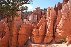
Bryce Canyon National Park is an American national park located in southwestern Utah. The major feature of the park is Bryce Canyon, which despite its name, is not a canyon, but a collection of giant natural amphitheaters along the eastern side of the Paunsaugunt Plateau. Bryce is distinctive due to geological structures called hoodoos, formed by frost weathering and stream erosion of the river and lake bed sedimentary rocks. The red, orange, and white colors of the rocks provide spectacular views for park visitors. Bryce Canyon National Park is much smaller and sits at a much higher elevation than nearby Zion National Park. The rim at Bryce varies from 8,000 to 9,000 feet.
The exposed geology of the Bryce Canyon area in Utah shows a record of deposition that covers the last part of the Cretaceous Period and the first half of the Cenozoic era in that part of North America. The ancient depositional environment of the region around what is now Bryce Canyon National Park varied from the warm shallow sea in which the Dakota Sandstone and the Tropic Shale were deposited to the cool streams and lakes that contributed sediment to the colorful Claron Formation that dominates the park's amphitheaters.

The Paunsaugunt Plateau is a dissected plateau, rising to an elevation of 7,000–9,300 feet (2,100–2,800 m), in southwestern Utah in the United States. Located in northern Kane County and southwestern Garfield County, it is approximately 10 miles (16 km) wide, and extends southward from the Sevier Plateau approximately 25 miles (40 km), terminating in the Pink Cliffs at the southern end.
The Pink Cliffs are a series of highly dissected cliffs on the Colorado Plateau in Garfield, Iron, and Kane counties in southwestern Utah, United States. Contrary to the implication of the name, the cliffs are not a single set of rock formations, but actually a geological formation that manifests itself in multiple sets of rock formations.
State Route 12 or Scenic Byway 12 (SR-12), also known as "Highway 12 — A Journey Through Time Scenic Byway", is a 122.863-mile-long (197.729 km) state highway designated an All-American Road located in Garfield County and Wayne County, Utah, United States.

Bryce Canyon Lodge is a lodging facility in Bryce Canyon National Park, Utah, United States, built between 1924 and 1925 using local materials. Designed by architect Gilbert Stanley Underwood, the lodge is an excellent example of National Park Service rustic design, and the only remaining completely original structure that Underwood designed for Bryce Canyon National Park, Zion National Park, and the North Rim of the Grand Canyon.

The Hole in the Rock Trail is a historic trail running east-southeast from the town of Escalante in southern Utah in the western United States. The Mormon trailblazers who established this trail crossed the Colorado River and ended their journey in the town of Bluff. The Hole-in-the-Rock expedition established the trail in 1879. The trail is located within the borders of the Grand Staircase-Escalante National Monument, the adjacent Glen Canyon National Recreation Area and federal Bureau of Land Management (BLM) public land to the east of the Colorado River. A geologic feature called the Hole in the Rock gave the trail its name. A modern unpaved road called the Hole-in-the-Rock Road closely follows this historic trail to the point where it enters the Glen Canyon National Recreation Area. The modern road is an important access route for visiting the Canyons of the Escalante and the Devils Garden. The trail is listed on the National Register of Historic Places, being added to that list in 1982.
Bryce Canyon Airport is a public airport located four miles (6 km) north of Bryce Canyon, in Garfield County, Utah, United States. It is owned by Garfield County.

The Serpents Trail, also known as the Trail of the Serpents and the Serpentine Trail, is a trail within the Colorado National Monument in Mesa County, Colorado, United States, that is listed on the National Register of Historic Places.

This is a list of the National Register of Historic Places listings in Garfield County, Utah.

The Old Administration Building at Bryce Canyon National Park, Utah, U.S.A., also known as the Bryce Canyon Nature Museum, was the first National Park Service building built within the park. Located near Sunrise Point in a heavily used portion of the park, the building was designed by the National Park Service Branch of Plans and Designs in the National Park Service Rustic style preferred at the time for park structures. It is in the immediate vicinity of the Bryce Inn.

The Utah Parks Company Service Station in Bryce Canyon National Park was built in 1947 to serve automobile-borne visitors to the park. The service station was designed for the Utah Parks Company by architect Ambrose Spence in a style that was sympathetic to the prevailing National Park Service Rustic style, but was much simpler and more modern in character. In this manner, it foreshadowed the consciously simplified designs developed during the Mission 66 project.

State Route 143 (SR-143) is a state highway in the U.S. state of Utah. The entire highway has been designated the Brian Head-Panguitch Lake Scenic Byway as part of the Utah Scenic Byways program. This road has also been designated as Utah's Patchwork Parkway as part of the National Forest Scenic Byway program.

The historical buildings and structures of Zion National Park represent a variety of buildings, interpretive structures, signs and infrastructure associated with the National Park Service's operations in Zion National Park, Utah. Structures vary in size and scale from the Zion Lodge to road culverts and curbs, nearly all of which were designed using native materials and regional construction techniques in an adapted version of the National Park Service Rustic style. A number of the larger structures were designed by Gilbert Stanley Underwood, while many of the smaller structures were designed or coordinated with the National Park Service Branch of Plans and Designs. The bulk of the historic structures date to the 1920s and 1930s. Most of the structures of the 1930s were built using Civilian Conservation Corps labor.
The Trail of the Ancients is a collection of National Scenic Byways located in the U.S. Four Corners states of Utah, Colorado, New Mexico, and Arizona. These byways comprise:
This is a list of the National Register of Historic Places listings in Bryce Canyon National Park.

The Under-the-Rim Trail is a 22.9-mile (36.9 km) hiking trail in Bryce Canyon National Park, Utah. The trail was established by the National Park Service to provide access to the portions of the park located below the rim of the Paunsaugunt Plateau, whose edge forms the eroded natural amphitheater for which the park is famous. Plans dating to 1932 proposed the trail so that wooded portions of the park's east side could be accessed, primarily for fire suppression activities rather than for access to scenic features. Work began on the trail in 1934, using Civilian Conservation Corps labor from CCC Camp NP-3, with work continuing into 1935.
The Riggs Spring Fire Trail, also known as the Riggs Spring Loop Trail, was built in Bryce Canyon National Park in 1936 to provide access to the park's backcountry for fire suppression crews. The approximately 8-mile (13 km) trail is significant for its association with Civilian Conservation Corps labor from CCC Camp NP-3, and represents the last link in the series of access trails built in the mid-1930s, beginning with the Under-the-Rim Trail, also listed on the National Register of Historic Places. The trail descends eastward from Rainbow Point in the southern end of the park, descending along The Promontory, and turning back south, then west, then north to return to the road via Yovimpa Pass, ending at returning to Rainbow Point. The primary purpose of the trail was to provide reliable access to the backcountry of the southern portion of the park.

The Grand Canyon Inn and Campground, also known as the North Rim Inn, were built by the William W. Wylie and the Utah Parks Company as inexpensive tourist accommodations on the North Rim of the Grand Canyon, in Grand Canyon National Park. Intended to complement the more expensive Grand Canyon Lodge, the cabins and Inn were located near Bright Angel Point, but father back than their more expensive counterparts, near the Grand Canyon North Rim Headquarters. The design of the cabins and the redesign of the Inn building were undertaken by architect Gilbert Stanley Underwood.
Architects of the National Park Service are the architects and landscape architects who were employed by the National Park Service (NPS) starting in 1918 to design buildings, structures, roads, trails and other features in the United States National Parks. Many of their works are listed on the National Register of Historic Places, and a number have also been designated as National Historic Landmarks.