Hoodoo (geology)

Last updated
Hoodoos in Bryce Canyon National Park, Utah USA 10654 Bryce Canyon Luca Galuzzi 2007.jpg
Hoodoos in Bryce Canyon National Park, Utah

A hoodoo (also called a tent rock, fairy chimney, or earth pyramid) is a tall, thin spire of rock formed by erosion. Hoodoos typically consist of relatively soft rock topped by harder, less easily eroded stone that protects each column from the elements. They generally form within sedimentary rock and volcanic rock formations.

Contents

Hoodoos range in size from the height of an average human to heights exceeding a 10-story building. Hoodoo shapes are affected by the erosional patterns of alternating hard and softer rock layers. Minerals deposited within different rock types can cause hoodoos to have different colors throughout their height.

Etymology

In certain regions of western North America these rocky structures are called hoodoos. The name is derived from Hoodoo spirituality, in which certain natural forms are said to possess certain powers, but by the late 19th century, this spirituality became associated with bad luck. [1] Prior to the English name for these geographic formations they were already the origin of many legends from Native Americans. For example, hoodoos in Bryce Canyon National Park were considered petrified remains of ancient beings who had been sanctioned for misbehavior. [2]

Occurrence

Hoodoos in Sierra de Organos National Park, Mexico SierradeOrganos.jpg
Hoodoos in Sierra de Organos National Park, Mexico

Hoodoos are found mainly in the desert in dry, hot areas. In common usage, the difference between hoodoos and pinnacles (or spires) is that hoodoos have a variable thickness often described as having a "totem pole-shaped body". A spire, however, has a smoother profile or uniform thickness that tapers from the ground upward.

Goblin Valley State Park, Utah Utah - North America - Goblin Valley State Park - Hoodoos (4892269801).jpg
Goblin Valley State Park, Utah

Hoodoo formations are commonly found on the Colorado Plateau and in the Badland regions of the northern Great Plains (both in North America). While hoodoos are scattered throughout these areas, nowhere in the world are they so abundant as in the northern section of Bryce Canyon National Park, located in the U.S. state of Utah. [3] Hoodoos are also very prominent a few hundred miles away at Goblin Valley State Park on the eastern side of the San Rafael Swell, at Kasha-Katuwe Tent Rocks National Monument in north central New Mexico, and in the Chiricahua National Monument of Southeast Arizona. [4] Some hoodoos are found in Sombrerete, Mexico at the Sierra de Organos National Park.

Tent rocks (peribacasi) near Cavusin, Cappadocia, Turkey Tent rocks between Cavusin and Avanos.jpg
Tent rocks (peribacası) near Çavuşin, Cappadocia, Turkey

Hoodoos (peribacası) are also found in the Cappadocia region of Turkey, where houses have been carved into the formations. These hoodoos were depicted on the reverse of the Turkish 50 new lira banknote of 2005–2009. [5]

Hoodoos in Hin Khndzoresk, Armenia 2014 Prowincja Sjunik, Goris, Widok na Stary Goris (Kores) (04).jpg
Hoodoos in Hin Khndzoresk, Armenia

In Armenia, Hoodoos are found in Goris, Khndzoresk, Hin Khot and several other places in the marz of Syunik, where many were once carved into and inhabited or used.

Demoiselles coiffees, Pontis, Alpes-de-Haute-Provence, France DemoisellesCoiffeesPontis.jpg
Demoiselles coiffées, Pontis, Alpes-de-Haute-Provence, France

In French, the formations are called demoiselles coiffées (ladies with hairdos) or cheminées de fées (fairy chimneys) and several are found in the Alpes-de-Haute-Provence; one of the best-known examples is the formation called Demoiselles Coiffées de Pontis. [6] [7]

The hoodoo stones on the northern coast of Taiwan are unusual for their coastal setting. The stones formed as the seabed rose rapidly out of the ocean during the Miocene epoch. [8] Efforts have been made to slow the erosion in the case of iconic specimens in Wanli.

The Awa Sand Pillars in Tokushima Prefecture, Japan, are hoodoos made from layers of compacted gravel and sandstone. [9]

Đavolja Varoš (Devil's Town) hoodoos in Serbia feature about 200 formations described as earth pyramids or towers by local inhabitants. Since 1959, Đavolja Varoš has been protected by the state. The site was also a nominee in the New Seven Wonders of Nature campaign. [10]

The hoodoos in Drumheller, Alberta, are composed of clay and sand deposited between 70 and 75 million years ago during the Cretaceous Period. These hoodoos can maintain a unique mushroom-like appearance as the underlying base erodes at a faster rate compared to the capstones at a rate of nearly one centimeter per year, faster than most geologic structures. [11]

Formation

Davolja Varos (Devil's Town) in Serbia - a volcanic rock formation with andesite caps Davolja Varos.jpg
Đavolja Varoš (Devil's Town) in Serbia – a volcanic rock formation with andesite caps

Hoodoos typically form in areas where a thick layer of a relatively soft rock, such as mudstone, poorly cemented sandstone, or tuff (consolidated volcanic ash), is covered by a thin layer of hard rock, such as well-cemented sandstone, limestone, or basalt. In glaciated mountainous valleys the soft eroded material may be glacial till with the protective capstones being large boulders in the till. Over time, cracks in the resistant layer allow the much softer rock beneath to be eroded and washed away. Hoodoos form where a small cap of the resistant layer remains, and protects a cone of the underlying softer layer from erosion. The heavy cap pressing downward gives the pedestal of the hoodoo its strength to resist erosion. [12] With time, erosion of the soft layer causes the cap to be undercut, eventually falling off, and the remaining cone is then quickly eroded. [13] [14]

Typically, hoodoos form from weathering processes that continuously work together in eroding the edges of a rock formation known as a fin. For example, the primary weathering force at Bryce Canyon is frost wedging. The hoodoos at Bryce Canyon experience more than 200 freeze-thaw cycles each year. In the winter, melting snow, in the form of water, seeps into the cracks and then freezes at night. When water freezes, it expands by almost 10%, prying open the cracks bit by bit, making them even wider, similar to the way a pothole forms in a paved road.

In addition to frost wedging, rain is another weathering process causing erosion. In most places today, rainwater is slightly acidic, which lets the weak carbonic acid slowly dissolve limestone grain by grain. It is this process that rounds the edges of hoodoos and gives them their lumpy and bulging profiles. Where internal mudstone and siltstone layers interrupt the limestone, one may expect the rock to be more resistant to the chemical weathering because of the comparative lack of limestone. Many of the more durable hoodoos are capped with a special kind of magnesium-rich limestone called dolomite. Dolomite, being fortified by the mineral magnesium, dissolves at a much slower rate, and consequently protects the weaker limestone underneath it. Rain is also the chief source of erosion (removing the debris). In the summer, monsoon-type rainstorms travel through the Bryce Canyon region bringing short-duration high-intensity rain. [15]

Hoodoo formation-Big.jpg
Progressive erosion producing plateau, fin, window (or arch), and hoodoos
Les Orgues d'Ille-sur-Tet, Southern France Les Orgues d'Ille-sur-Tet.jpg
Les Orgues d'Ille-sur-Têt, Southern France

See also

Related Research Articles

<span class="mw-page-title-main">Bryce Canyon National Park</span> National park in Utah, United States

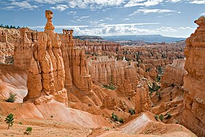
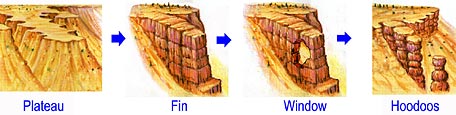
Bryce Canyon National Park is an American national park located in southwestern Utah. The major feature of the park is Bryce Canyon, which despite its name, is not a canyon, but a collection of giant natural amphitheaters along the eastern side of the Paunsaugunt Plateau. Bryce is distinctive due to geological structures called hoodoos, formed by frost weathering and stream erosion of the river and lake bed sedimentary rock. The red, orange, and white colors of the rocks provide spectacular views for park visitors. Bryce Canyon National Park is much smaller and sits at a much higher elevation than nearby Zion National Park. The rim at Bryce varies from 8,000 to 9,000 feet.

<span class="mw-page-title-main">Natural arch</span> Arch-shaped natural rock formation

A natural arch, natural bridge, or rock arch is a natural landform where an arch has formed with an opening underneath. Natural arches commonly form where inland cliffs, coastal cliffs, fins or stacks are subject to erosion from the sea, rivers or weathering.

<span class="mw-page-title-main">Cedar Breaks National Monument</span> National monument in Iron County, Utah, United States

Cedar Breaks National Monument is a U.S. National Monument located in the U.S. state of Utah near Cedar City. Cedar Breaks is a natural amphitheater, stretching across 3 miles (4.8 km), with a depth of over 2,000 feet (610 m). The elevation of the rim of the amphitheater is over 10,000 feet (3,000 m) above sea level. Rising above the rim is the prominent Brian Head, the peak of which lies a short distance outside of the National Monument boundary.

<span class="mw-page-title-main">Badlands</span> Type of heavily eroded terrain

Badlands are a type of dry terrain where softer sedimentary rocks and clay-rich soils have been extensively eroded. They are characterized by steep slopes, minimal vegetation, lack of a substantial regolith, and high drainage density. Ravines, gullies, buttes, hoodoos and other such geologic forms are common in badlands.

<span class="mw-page-title-main">Geology of the Grand Canyon area</span> Aspect of geology

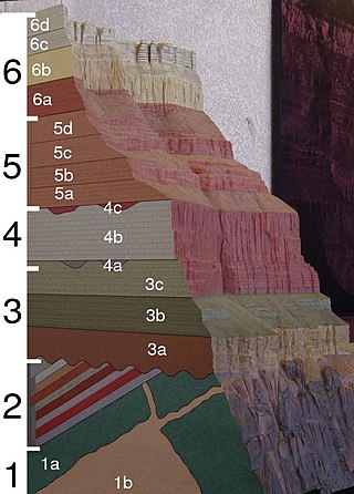
The geology of the Grand Canyon area includes one of the most complete and studied sequences of rock on Earth. The nearly 40 major sedimentary rock layers exposed in the Grand Canyon and in the Grand Canyon National Park area range in age from about 200 million to nearly 2 billion years old. Most were deposited in warm, shallow seas and near ancient, long-gone sea shores in western North America. Both marine and terrestrial sediments are represented, including lithified sand dunes from an extinct desert. There are at least 14 known unconformities in the geologic record found in the Grand Canyon.

<span class="mw-page-title-main">Geology of the Zion and Kolob canyons area</span> Geology of Zion National Park in Utah

The geology of the Zion and Kolob canyons area includes nine known exposed formations, all visible in Zion National Park in the U.S. state of Utah. Together, these formations represent about 150 million years of mostly Mesozoic-aged sedimentation in that part of North America. Part of a super-sequence of rock units called the Grand Staircase, the formations exposed in the Zion and Kolob area were deposited in several different environments that range from the warm shallow seas of the Kaibab and Moenkopi formations, streams and lakes of the Chinle, Moenave, and Kayenta formations to the large deserts of the Navajo and Temple Cap formations and dry near shore environments of the Carmel Formation.

The exposed geology of the Bryce Canyon area in Utah shows a record of deposition that covers the last part of the Cretaceous Period and the first half of the Cenozoic era in that part of North America. The ancient depositional environment of the region around what is now Bryce Canyon National Park varied from the warm shallow sea in which the Dakota Sandstone and the Tropic Shale were deposited to the cool streams and lakes that contributed sediment to the colorful Claron Formation that dominates the park's amphitheaters.

<span class="mw-page-title-main">Colorado Plateau</span> Plateau in southwestern United States

The Colorado Plateau, also known as the Colorado Plateau Province, is a physiographic and desert region of the Intermontane Plateaus, roughly centered on the Four Corners region of the southwestern United States. This province covers an area of 336,700 km2 (130,000 mi2) within western Colorado, northwestern New Mexico, southern and eastern Utah, northern Arizona, and a tiny fraction in the extreme southeast of Nevada. About 90% of the area is drained by the Colorado River and its main tributaries: the Green, San Juan, and Little Colorado. Most of the remainder of the plateau is drained by the Rio Grande and its tributaries.

<span class="mw-page-title-main">Grand Staircase</span> Landform in Utah and Arizona, United States

The Grand Staircase is an immense sequence of sedimentary rock layers that stretch south from Bryce Canyon National Park and Grand Staircase–Escalante National Monument, through Zion National Park, and into Grand Canyon National Park.

<span class="mw-page-title-main">Kasha-Katuwe Tent Rocks National Monument</span> United States National Monument

Kasha-Katuwe Tent Rocks National Monument is a U.S. National Monument located approximately 40 miles (64 km) southwest of Santa Fe, New Mexico, near Cochiti Pueblo. Managed by the Bureau of Land Management (BLM), it was established as a U.S. National Monument by President Bill Clinton in January 2001. Kasha-Katuwe means "white cliffs" in the Pueblo language Keresan. The monument is a unit of the BLM's National Conservation Lands. The monument closed in 2020 due to Covid and has yet to reopen.

<span class="mw-page-title-main">Goblin Valley State Park</span> State park in Utah, United States

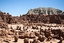
Goblin Valley State Park is a state park of Utah, in the United States. The park features thousands of hoodoos, referred to locally as goblins, which are formations of mushroom-shaped rock pinnacles, some as tall as several yards (meters). The distinct shapes of these rocks result from an erosion-resistant layer of rock atop relatively softer sandstone. Goblin Valley State Park and Bryce Canyon National Park, also in Utah about 190 miles (310 km) to the southwest, contain some of the largest occurrences of hoodoos in the world.

<span class="mw-page-title-main">Geology of the Capitol Reef area</span>

The exposed geology of the Capitol Reef area presents a record of mostly Mesozoic-aged sedimentation in an area of North America in and around Capitol Reef National Park, on the Colorado Plateau in southeastern Utah.

<span class="mw-page-title-main">Đavolja Varoš</span> Protected area

Đavolja varoš is a rock formation consisting of about 200 earth pyramids or "towers", located in southern Serbia on the Radan Mountain, in the municipality of Kuršumlija. There are several similar geological formations in the world, but Đavolja Varoš has the most numerous and the tallest "towers".

Caprock or cap rock is a more resistant rock type overlying a less resistant rock type, analogous to an upper crust on a cake that is harder than the underlying layer.

<span class="mw-page-title-main">Bisti/De-Na-Zin Wilderness</span> Wilderness in New Mexico, United States

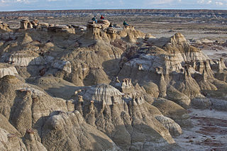
The Bisti/De-Na-Zin Wilderness is a 45,000-acre (18,000 ha) wilderness area located in San Juan County in the U.S. state of New Mexico. Established in 1984, the Wilderness is a desolate area of steeply eroded badlands managed by the Bureau of Land Management, except three parcels of private Navajo land within its boundaries. The John D. Dingell, Jr. Conservation, Management, and Recreation Act, signed March 12, 2019, expanded the Bisti/De-Na-Zin Wilderness by approximately 2,250 acres.

<span class="mw-page-title-main">Balancing rock</span> Naturally occurring precariously balanced rock

A balancing rock, also called a balanced rock or precarious boulder, is a naturally occurring geological formation featuring a large rock or boulder, sometimes of substantial size, resting on other rocks, bedrock, or on glacial till. Some formations known by this name only appear to be balancing, but are in fact firmly connected to a base rock by a pedestal or stem.

<span class="mw-page-title-main">Cedar Mesa Sandstone</span>

Cedar Mesa Sandstone is a sandstone member of the Cutler Formation, found in southeast Utah, southwest Colorado, northwest New Mexico, and northeast Arizona.

<span class="mw-page-title-main">Ah-Shi-Sle-Pah Wilderness</span> Protected wilderness area in New Mexico, United States

Ah-Shi-Sle-Pah Wilderness is located in San Juan County, New Mexico, between Chaco Canyon and the De-Na-Zin Wilderness. Its name is a phonetic transliteration of Navajo "áshįįhłibá" meaning "salt, it is grey ". The wilderness has multicolored badlands, sandstone hoodoos, petrified wood and dinosaur bones, similar to those found in the nearby Bisti Badlands and De-Na-Zin Wilderness.

<span class="mw-page-title-main">Demoiselles Coiffées de Pontis</span> Rock formation in France

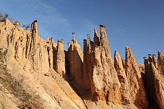
The Demoiselles Coiffées de Pontis is a rock formation in Pontis, near Embrun in the French Alps, located on the edge of the Lac de Serre-Ponçon. The formation consists of a number of hoodoos, described as a "set of narrowly-tapered rock columns....topped with a large rock balanced neatly on the tip." In French, such structures are referred to as Demoiselles Coiffées, or more often Cheminées de Fées. In Théus, there is a concentration referred to as La Salle de Bal des Demoiselles Coiffées, although these structures also exist in isolation. Two other significant sites exist 1 kilometer away on a mountainside near Remollon.

<span class="mw-page-title-main">Geological history of the Chiricahua Mountains</span> Review of the topic

The Geologic history of the Chiricahua Mountains concerns the Chiricahua Mountains, an inactive volcanic range located in Coronado National Forest of southeastern Arizona, in the United States. They are part of an "archipelago" of mountain ranges known as the sky islands that connect the Sierra Madre Occidental in Mexico with the Rocky Mountains. The Chiricahua Mountains are home to a number of unusual geologic features associated with the Turkey Creek Caldera, some of which are protected by Chiricahua National Monument. The landscape has been dominantly shaped by faulting due to Basin and Range extension during the Miocene, volcanic activity, and erosion.

References

  1. "hoodoo | Origin and meaning of hoodoo". Online Etymology Dictionary. Retrieved 2021-09-23.
  2. "American Indian History". Brice Canyon National Park, Utah. National Park Service. 23 June 2020. Retrieved 1 June 2022.
  3. "Geologic Formations – Bryce Canyon National Park (U.S. National Park Service)". www.nps.gov. Retrieved 2019-08-21.
  4. "Chiricahua National Monument (U.S. National Park Service)". www.nps.gov. Retrieved 2019-08-13.
  5. Central Bank of the Republic of Turkey. "E8 – Fifty New Turkish Lira". Tcmb.gov.tr. Retrieved March 30, 2015.
  6. Haug, Émile (1907). Traité de géologie. Vol. 1. Librairie Armand Colin. p. 386.
  7. Godefroy, René (1940). La nature alpine: exposé de géographie physique. B. Arthaud. p. 121.
  8. Hong, Eason; Huang, Eugene (February 2001). "Formation of the pedestal rocks in the Taliao Formation, northern coast of Taiwan" (PDF). Western Pacific Earth Sciences. 1 (1): 99–106. Archived from the original (PDF) on February 5, 2017. Retrieved March 31, 2015.
  9. "The "Earth Pillars of Awa"! A Mysterious Phenomena Found in Only 3 Places Worldwide!". Stouchi Finder. Retrieved 2018-11-02.
  10. "Djavolja Varos, Rock Formation". New 7 Wonders. Archived from the original on July 9, 2009. Retrieved March 31, 2015.
  11. Royal Tyrrell Museum. "Hoodoos". Tyrrellmuseum.com. Archived from the original on 27 January 2020. Retrieved March 30, 2015.
  12. Bruthans, Jiri; Soukup, Jan; Vaculikova, Jana; Filippi, Michal; Schweigstillova, Jana; Mayo, Alan L.; Masin, David; Kletetschka, Gunther; Rihosek, Jaroslav (July 2014). "Sandstone landforms shaped by negative feedback between stress and erosion". Nature Geoscience. 7 (8): 597–601. Bibcode:2014NatGe...7..597B. doi:10.1038/ngeo2209. ISSN   1752-0908.
  13. Yilmaz, H.M.; Yakar, M.; Mutluoglu, O.; Kavurmaci, M.M.; Yurt, K. (2012). "Monitoring of soil erosion in Cappadocia region (Selime-Aksaray-Turkey)". Environmental Earth Sciences. 66 (1). Springer: 75–81. Bibcode:2012EES....66...75Y. doi:10.1007/s12665-011-1208-4. S2CID   140180182.
  14. Hopkins, R.L. (2003). "Coal Mine Canyon". Hiking the Southwest's Geology: Four Corners Region. The Mountaineers Books. pp. 107–108. ISBN   9780898868562.
  15. "Hoodoos". nps.gov. Retrieved 22 March 2015.

Further reading