Chiricahua National Monument

Last updated

Chiricahua National Monument
IUCN category V (protected landscape/seascape)
Chiricahua balanced rock.jpg
Rock formation on Echo Canyon Trail
USA Arizona relief location map.svg
Red pog.svg
Location in the United States
Usa edcp relief location map.png
Red pog.svg
Location in Arizona
Location Cochise County, Arizona, United States
Nearest city Willcox, Arizona
Coordinates 32°00′20″N109°21′24″W / 32.00569°N 109.35672°W / 32.00569; -109.35672
Area12,025 acres (48.66 km2) [1]
CreatedApril 18, 1924 (1924-April-18)
Visitors60,577(in 2018) [2]
Governing body National Park Service
Website Chiricahua National Monument

Chiricahua National Monument is a unit of the National Park System located in the Chiricahua Mountains of southeastern Arizona. The monument was established on April 18, 1924, to protect its extensive hoodoos and balancing rocks. The Faraway Ranch, which was owned at one time by Swedish immigrants Neil and Emma Erickson, is also preserved within the monument. [3]

Contents

Just over 85% of the monument is protected as the Chiricahua National Monument Wilderness. [4]

Visitor center

Park map (click on map to enlarge) Chiricahua park99.jpg
Park map (click on map to enlarge)

A visitor center is located two miles from the entrance to Chiricahua National Monument. The visitor center has exhibits relating to the geology, natural history, and cultural history of the area. A park ranger is available to provide visitors with trail guides and information. The main road, Bonita Canyon Drive, ventures 8 mi (13 km) east through the park, ending at Massai Point. Approximately 17 mi (27 km) of trails lead hikers through various ecosystems of meadows, forests, and rock formations.

The visitor center has a free shuttle that leaves each morning at 9:00am. The shuttle takes hikers to the Echo Canyon or Massai Point trailheads. Hikers return to the visitor center by following the designated trails. [5]

Geology

Located approximately 36 miles (58 km) southeast of Willcox, Arizona, the monument preserves the remains of an immense volcanic eruption that shook the region about 27 million years ago. The thick, white-hot ash spewed forth from the nearby Turkey Creek Caldera, cooled and hardened into rhyolitic tuff, laying down almost 2,000 ft (610 m) of highly siliceous, dark volcanic ash and pumice. The volcanic material eventually eroded into the natural rock formations of the present monument. [6]

Historic Designed Landscape

Chiricahua National Monument Historic Designed Landscape
Location12856 E. Rhyolite Canyon Rd., Chiricahua National Monument, near Willcox, Arizona
Areaapprox. 10,000 acres [7]
Built1924–1940 [7]
MPS Historic Park Landscapes in National and State Parks MPS
NRHP reference No. 08001020 [8]
Added to NRHPOctober 31, 2008 [8]

Chiricahua National Monument Historic Designed Landscape is a historic district that covers roughly 80% of the national monument. The district was listed on the National Register of Historic Places on October 31, 2008. [8] [7] [9]

It was the 18th property listed as a featured property of the week in a program of the National Park Service that began in July, 2008. [8] [10]

Redesignation as National Park

In 2022, the US Senate passed S. 1320 to redesignate the monument as a national park. [11] [12] The bill did not make it out of committee in the House and died with the conclusion of the 117th Congress. In early 2023, Senator Mark Kelly introduced S 736 in the Senate, while Representative Juan Ciscomani introduced HR 1479 in the House to redesignate the Monument as a Park. [13] [14] The 2023 bills passed out of committee in the Senate but have not passed out of committee in the House.

Missing naturalist

On January 13, 1980, Paul Fugate, a National Park Service naturalist and law enforcement ranger, disappeared after leaving the monument headquarters while in uniform, to check trails leading to the recently acquired Faraway Ranch. An acquaintance claimed to have seen him later that afternoon, slumped between two men in a pickup truck. Despite an extensive search of the rugged 17 sq mi (44 km2) monument area by authorities and search and rescue teams, no trace of him has been found. [15] [16] [17]

Chiricahua Chiricahua National Monument HDR Panorama.jpg
180° panoramic view of Chiricahua National Monument

Climate

According to the Köppen Climate Classification system, Chiricahua National Monument has a hot-summer mediterranean climate, abbreviated "Csa" on climate maps. The hottest temperature recorded at Chiricahua National Monument was 109 °F (42.8 °C) on July 13, 1909, while the coldest temperature recorded was −10 °F (−23.3 °C) on January 7, 1913. [18]

Climate data for Chiricahua National Monument, Arizona, 1991–2020 normals, extremes 1909–2007
MonthJanFebMarAprMayJunJulAugSepOctNovDecYear
Record high °F (°C)80
(27)
80
(27)
86
(30)
93
(34)
104
(40)
108
(42)
109
(43)
103
(39)
100
(38)
95
(35)
85
(29)
82
(28)
109
(43)
Mean daily maximum °F (°C)56.0
(13.3)
60.6
(15.9)
66.5
(19.2)
73.8
(23.2)
82.7
(28.2)
91.4
(33.0)
90.2
(32.3)
86.7
(30.4)
83.8
(28.8)
76.4
(24.7)
66.4
(19.1)
55.7
(13.2)
74.2
(23.4)
Daily mean °F (°C)43.1
(6.2)
46.6
(8.1)
51.5
(10.8)
57.2
(14.0)
65.7
(18.7)
74.2
(23.4)
75.1
(23.9)
73.4
(23.0)
70.2
(21.2)
61.8
(16.6)
52.0
(11.1)
43.1
(6.2)
59.5
(15.3)
Mean daily minimum °F (°C)30.3
(−0.9)
32.6
(0.3)
36.5
(2.5)
40.5
(4.7)
48.8
(9.3)
57.0
(13.9)
60.0
(15.6)
60.0
(15.6)
56.6
(13.7)
47.2
(8.4)
37.5
(3.1)
30.5
(−0.8)
44.8
(7.1)
Record low °F (°C)−10
(−23)
7
(−14)
10
(−12)
20
(−7)
19
(−7)
35
(2)
40
(4)
44
(7)
33
(1)
21
(−6)
8
(−13)
−1
(−18)
−10
(−23)
Average precipitation inches (mm)1.32
(34)
1.28
(33)
1.19
(30)
0.27
(6.9)
0.30
(7.6)
0.86
(22)
3.81
(97)
4.56
(116)
1.59
(40)
0.99
(25)
1.04
(26)
1.50
(38)
18.71
(475.5)
Average snowfall inches (cm)1.3
(3.3)
0.5
(1.3)
0.2
(0.51)
0.0
(0.0)
0.0
(0.0)
0.0
(0.0)
0.0
(0.0)
0.0
(0.0)
0.0
(0.0)
0.1
(0.25)
0.4
(1.0)
1.2
(3.0)
3.7
(9.36)
Average precipitation days (≥ 0.01 in)5.45.44.62.02.23.513.112.66.34.24.05.568.8
Average snowy days (≥ 0.1 in)0.50.50.10.00.00.00.00.00.00.10.20.41.8
Source 1: NOAA [19]
Source 2: National Weather Service [18]

See also

Flag of Arizona.svg  Arizonaportal

Related Research Articles

<span class="mw-page-title-main">Grand Canyon National Park</span> National park in Arizona, United States

Grand Canyon National Park, located in northwestern Arizona, is the 15th site in the United States to have been named as a national park. The park's central feature is the Grand Canyon, a gorge of the Colorado River, which is often considered one of the Wonders of the World. The park, which covers 1,217,262 acres of unincorporated area in Coconino and Mohave counties, received more than 4.7 million recreational visitors in 2022, which is the second highest count of all American national parks after Great Smoky Mountains National Park. The Grand Canyon was designated a World Heritage Site by UNESCO in 1979. The park celebrated its 100th anniversary on February 26, 2019.

<span class="mw-page-title-main">Bryce Canyon National Park</span> National park in Utah, United States

Bryce Canyon National Park is an American national park located in southwestern Utah. The major feature of the park is Bryce Canyon, which despite its name, is not a canyon, but a collection of giant natural amphitheaters along the eastern side of the Paunsaugunt Plateau. Bryce is distinctive due to geological structures called hoodoos, formed by frost weathering and stream erosion of the river and lake bed sedimentary rock. The red, orange, and white colors of the rocks provide spectacular views for park visitors. Bryce Canyon National Park is much smaller and sits at a much higher elevation than nearby Zion National Park. The rim at Bryce varies from 8,000 to 9,000 feet.

<span class="mw-page-title-main">National Park Service</span> United States federal agency

The National Park Service (NPS) is an agency of the United States federal government, within the U.S. Department of the Interior. The service manages all national parks; most national monuments; and other natural, historical, and recreational properties, with various title designations. The United States Congress created the agency on August 25, 1916, through the National Park Service Organic Act. Its headquarters are in Washington, D.C., within the main headquarters of the Department of the Interior.

<span class="mw-page-title-main">Cedar Breaks National Monument</span> National monument in Iron County, Utah, United States

Cedar Breaks National Monument is a U.S. National Monument located in the U.S. state of Utah near Cedar City. Cedar Breaks is a natural amphitheater, stretching across 3 miles (4.8 km), with a depth of over 2,000 feet (610 m). The elevation of the rim of the amphitheater is over 10,000 feet (3,000 m) above sea level. Rising above the rim is the prominent Brian Head, the peak of which lies a short distance outside of the National Monument boundary.

<span class="mw-page-title-main">Colorado National Monument</span> National Park Service unit in Colorado, United States

Colorado National Monument is a National Park Service unit near the city of Grand Junction, Colorado. Sheer-walled canyons cut deep into sandstone and granite–gneiss–schist rock formations. This is an area of desert land high on the Colorado Plateau, with pinyon and juniper forests on the plateau. The park hosts a wide range of wildlife, including red-tailed hawks, golden eagles, ravens, jays, desert bighorn sheep, and coyotes. Activities include hiking, horseback riding, road bicycling, and scenic drives; a visitor center on the west side contains a natural history museum and gift shop. There are scenic views from trails, Rim Rock Drive, which winds along the plateau, and the campground. Nearby are the Book Cliffs and the largest flat-topped mountain in the world, the Grand Mesa.

<span class="mw-page-title-main">Colorado Plateau</span> Plateau in southwestern United States

The Colorado Plateau, also known as the Colorado Plateau Province, is a physiographic and desert region of the Intermontane Plateaus, roughly centered on the Four Corners region of the southwestern United States. This province covers an area of 336,700 km2 (130,000 mi2) within western Colorado, northwestern New Mexico, southern and eastern Utah, northern Arizona, and a tiny fraction in the extreme southeast of Nevada. About 90% of the area is drained by the Colorado River and its main tributaries: the Green, San Juan, and Little Colorado. Most of the remainder of the plateau is drained by the Rio Grande and its tributaries.

<span class="mw-page-title-main">Hoodoo (geology)</span> Tall, thin spire of relatively soft rock usually topped by harder rock

A hoodoo is a tall, thin spire of rock formed by erosion. Hoodoos typically consist of relatively soft rock topped by harder, less easily eroded stone that protects each column from the elements. They generally form within sedimentary rock and volcanic rock formations.

<span class="mw-page-title-main">Bandelier National Monument</span> United States historic place

Bandelier National Monument is a 33,677-acre (13,629 ha) United States National Monument near Los Alamos in Sandoval and Los Alamos counties, New Mexico. The monument preserves the homes and territory of the Ancestral Puebloans of a later era in the Southwest. Most of the pueblo structures date to two eras, dating between 1150 and 1600 AD.

<span class="mw-page-title-main">Chiricahua Mountains</span> Mountain range in Arizona, United States

The Chiricahua Mountains massif is a large mountain range in southeastern Arizona which is part of the Basin and Range province of the west and southwestern United States and northwest Mexico; the range is part of the Coronado National Forest. The highest point, Chiricahua Peak, rises 9,759 feet (2,975 m) above sea level, approximately 6,000 feet (1,800 m) above the surrounding valleys. The range takes its name from the Chiricahua Apaches native to the region.

<span class="mw-page-title-main">Gila Cliff Dwellings National Monument</span> United States historic place

Gila Cliff Dwellings National Monument is a U.S. National Monument created to protect Mogollon cliff dwellings in the Gila Wilderness on the headwaters of the Gila River in southwest New Mexico. The 533-acre (2.16 km2) national monument was established by President Theodore Roosevelt through executive proclamation on November 16, 1907. It is located in the extreme southern portion of Catron County. Visitors can access the monument by traveling northbound from Silver City, New Mexico, 45 miles (72 km) on NM 15.

<span class="mw-page-title-main">Kasha-Katuwe Tent Rocks National Monument</span> United States National Monument

Kasha-Katuwe Tent Rocks National Monument is a U.S. National Monument located approximately 40 miles (64 km) southwest of Santa Fe, New Mexico, near Cochiti Pueblo. Managed by the Bureau of Land Management (BLM), it was established as a U.S. National Monument by President Bill Clinton in January 2001. Kasha-Katuwe means "white cliffs" in the Pueblo language Keresan. The monument is a unit of the BLM's National Conservation Lands. The monument closed in 2020 due to Covid and has yet to reopen.

<span class="mw-page-title-main">Canyon de Chelly National Monument</span> National Park Service unit in Apache County, Arizona, US

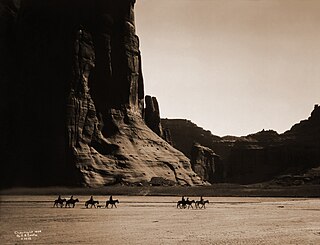
Canyon de Chelly National Monument was established on April 1, 1931, as a unit of the National Park Service. Located in northeastern Arizona, it is within the boundaries of the Navajo Nation and lies in the Four Corners region. Reflecting one of the longest continuously inhabited landscapes of North America, it preserves ruins of the indigenous tribes that lived in the area, from the Ancestral Puebloans to the Navajo. The monument covers 83,840 acres and encompasses the floors and rims of the three major canyons: de Chelly, del Muerto, and Monument. These canyons were cut by streams with headwaters in the Chuska Mountains just to the east of the monument. None of the land is federally owned. Canyon de Chelly is one of the most visited national monuments in the United States.

<span class="mw-page-title-main">Walnut Canyon National Monument</span> Protected area in Coconino County, Arizona

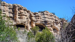
Walnut Canyon National Monument is a United States National Monument located about 10 mi (16 km) southeast of downtown Flagstaff, Arizona, near Interstate 40. The canyon rim elevation is 6,690 ft (2,040 m); the canyon's floor is 350 ft (110 m) lower. A 0.9 mi (1.4 km) long loop trail descends 185 ft (56 m) into the canyon passing 25 cliff dwelling rooms constructed by the Sinagua, a pre-Columbian cultural group that lived in Walnut Canyon from about 1100 to 1250 AD. Other contemporary habitations of the Sinagua people are preserved in the nearby Tuzigoot and Montezuma Castle national monuments.

<span class="mw-page-title-main">Coronado National Forest</span> Managed forest in southern Arizona and New Mexico

The Coronado National Forest is a United States National Forest that includes an area of about 1.78 million acres (7,200 km2) spread throughout mountain ranges in southeastern Arizona and southwestern New Mexico.

<span class="mw-page-title-main">Santa Catalina Mountains</span> Mountain range in Pima and Pinal counties, Arizona, United States

The Santa Catalina Mountains, commonly referred to as the Catalina Mountains or the Catalinas, are north and northeast of Tucson in Arizona, United States, on Tucson's north perimeter. The mountain range is the most prominent in the Tucson area, with the highest average elevation. The highest point in the Catalinas is Mount Lemmon at an elevation of 9,157 feet (2,791 m) above sea level and receives 18 inches (46 cm) of precipitation annually.

<span class="mw-page-title-main">Saguaro National Park</span> National park in Arizona, United States

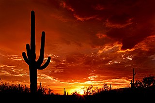
Saguaro National Park is a United States national park in Pima County, southeastern Arizona. The 92,000-acre (37,000 ha) park consists of two separate areas—the Tucson Mountain District (TMD), about 10 miles (16 km) west of Tucson, and the Rincon Mountain District (RMD), about 10 miles (16 km) east of the city. Both districts preserve Sonoran Desert landscapes, fauna, and flora, including the giant saguaro cactus.

<span class="mw-page-title-main">Faraway Ranch Historic District</span> Historic district in Arizona, United States

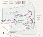
The Faraway Ranch Historic District is part of the Chiricahua National Monument in southeastern Arizona, and preserves an area associated with the final conflicts with the local Apache, one of the last frontier settlements, and in particular, its association with the people who promoted the establishment of the Chiricahua National Monument. Faraway Ranch is located in Bonita Canyon, which lies at an approximate altitude of 5160 feet and opens in a southwesterly direction into the Sulphur Springs Valley.

<span class="mw-page-title-main">Geological history of the Chiricahua Mountains</span> Review of the topic

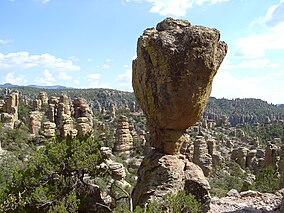
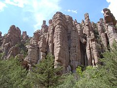
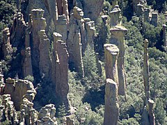
The Geologic history of the Chiricahua Mountains concerns the Chiricahua Mountains, an inactive volcanic range located in Coronado National Forest of southeastern Arizona, in the United States. They are part of an "archipelago" of mountain ranges known as the sky islands that connect the Sierra Madre Occidental in Mexico with the Rocky Mountains. The Chiricahua Mountains are home to a number of unusual geologic features associated with the Turkey Creek Caldera, some of which are protected by Chiricahua National Monument. The landscape has been dominantly shaped by faulting due to Basin and Range extension during the Miocene, volcanic activity, and erosion.

<span class="mw-page-title-main">Neil Erickson</span> Arizona pioneer (1859–1937)

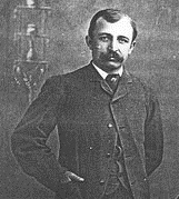
Neil Erickson was a Swedish-born American pioneer in Cochise County, Arizona. He and the members of his family were the founders and operators of Faraway Ranch now in the Faraway Ranch Historic District of the Chiricahua National Monument in the Chiricahua Mountains in southern Arizona.

<span class="mw-page-title-main">Bonita Canyon</span> Canyon in the Chiricahua National Monument, Arizona

Bonita Canyon is a box canyon on the western slope of the Chiricahua Mountains in southeastern Arizona, which lies at 5,360 feet (1,630 m) in elevation and opens in a southwesterly direction into the Sulphur Springs Valley.

References

  1. "National Park Service Acreage Reports" . Retrieved January 31, 2022.
  2. "NPS Annual Recreation Visits Report". National Park Service. Retrieved April 1, 2019.
  3. "Chiricahua National Monument: Nature & Science". National Park Service. Retrieved July 3, 2011.
  4. "Wilderness Connect". wilderness.net. Retrieved August 31, 2019.
  5. "Chiricahua National Monument (U.S. National Park Service)". www.nps.gov. Retrieved April 16, 2018.
  6. "Geology Field Notes: Chiricahua National Monument, Arizona". National Park Service. Retrieved July 3, 2011.
  7. 1 2 3 Pinto, Robin Lothrop and R. Brooks Jeffery and Mike Lovato (May 21, 2007). "National Register of Historic Places Nomination: Chiricahua National Monument Historic Designed Landscape / Wonderland of Rocks / Rhyolite Park / The Pinnacles/ Say Yahdesut "Point of Rocks"" (PDF). National Park Service. Archived from the original (PDF) on May 26, 2017. (268 pages including 17 maps and 199 photos, exterior and interior)
  8. 1 2 3 4 "Announcements and actions on properties for the National Register of Historic Places, November 7, 2008". New listings. National Park Service. Retrieved November 12, 2008.
  9. "National Register Information System". National Register of Historic Places . National Park Service. March 13, 2009.
  10. Kelty, Bennito L. "Senate OKs bill to establish Chiricahua National Park, measure still awaits House action". TucsonSentinel.com. TucsonSentinel.com. Retrieved January 2, 2023.
  11. "S.1320 — 117th Congress (2021-2022)". congress.gov. Library of Congress. Retrieved January 2, 2023.
  12. US Congress (July 19, 2023). "Senate Bill 736, 118th Congress". Congress.gov. Retrieved March 25, 2024.
  13. US Congress, Library of Congress (March 22, 2023). "All Information (Except Text) for H.R.1479 - Chiricahua National Park Act". Congress.gov. Retrieved March 25, 2024.
  14. "The Mystery of a Missing Naturalist May Lead to Legal Test of Dismissal". New York Times. August 16, 1981. p. 63. Retrieved May 20, 2018.
  15. Smith, Rick (March 5, 2009). "Where in the World is Paul Fugate?". National Parks Traveler. nationalparkstraveler.org. Retrieved May 20, 2018.
  16. Borrell, Brendan (July 1, 2021). "The Search for a Ranger Who Was Lost and Never Found". Outside. Retrieved December 8, 2023.
  17. 1 2 "NOAA Online Weather Data – NWS Tucson". National Weather Service. Retrieved March 26, 2023.
  18. "U.S. Climate Normals Quick Access – Station: Chiricahua NM, AZ". National Oceanic and Atmospheric Administration. Retrieved March 26, 2023.