Montezuma Castle National Monument

Last updated

Montezuma Castle National Monument
2021 Montezuma Castle 3.jpg
(2021)
USA Arizona relief location map.svg
Red pog.svg
Usa edcp relief location map.png
Red pog.svg
Location Yavapai County, Arizona, United States
Nearest city Camp Verde, Arizona
Coordinates 34°36′40″N111°50′12″W / 34.61111°N 111.83667°W / 34.61111; -111.83667
Area859.27 acres (347.73 ha) [1]
CreatedDecember 8, 1906 (1906-December-08)
Visitors390,151(in 2018) [2]
Governing body National Park Service
Website Montezuma Castle National Monument
DesignatedOctober 15, 1966
Reference no.66000082 [3]

Montezuma Castle National Monument protects a set of well-preserved dwellings located in Camp Verde, Arizona, which were built and used by the Sinagua people, a pre-Columbian culture closely related to the Hohokam and other indigenous peoples of the southwestern United States, [4] between approximately AD 1100 and 1425. The main structure comprises five stories and about 20 rooms and was built over the course of three centuries. [5]

Contents

Several Hopi clans and Yavapai communities trace their ancestries to early immigrants from the Montezuma Castle/Beaver Creek area. Archaeological evidence proves that the Hohokam and Hakataya settled around or in the Verde Valley. [5] Clan members periodically return to these ancestral homes for religious ceremonies.

Etymology

Neither part of the monument's name is correct. When European-Americans first observed the ruins in the 1860s, by then long-abandoned, they named them for the famous Aztec emperor Montezuma in the mistaken belief that he had been connected to their construction (see also Montezuma mythology). [6] Having no connections to the Aztecs, the Montezuma Castle was given that name due to the fact that the public had this image of the Aztecs creating any archaeological site. [7] In fact, the dwelling was abandoned more than 40 years before Montezuma was born, and was not a "castle" in the traditional sense, but instead functioned more like a "prehistoric high rise apartment complex". [5]

Cliff dwelling

Montezuma Castle is situated about 90 feet (27 m) up a sheer limestone cliff, facing the adjacent Beaver Creek, which drains into the perennial Verde River just north of Camp Verde. It is one of the best-preserved cliff dwellings in North America, in part because of its ideal placement in a natural alcove that protects it from exposure to the elements. The precariousness of the dwelling's location and its immense scale of floor space across five stories suggest that the Sinagua were daring builders and skilled engineers. Access into the structure was most likely permitted by a series of portable ladders, which made it difficult for enemy tribes to penetrate the natural defense of the vertical barrier. [7]

A view of Montezuma Castle from 1887 Sinagua historic.jpg
A view of Montezuma Castle from 1887

Perhaps the main reason the Sinagua chose to build the Castle so far above the ground, however, was to escape the threat of natural disaster in the form of the annual flooding of Beaver Creek. During the summer monsoon season, the creek frequently breached its banks, inundating the floodplain with water. The Sinagua recognized the importance of these floods to their agriculture, but likely also the potential destruction they presented to any structures built in the floodplain. Their solution was to build a permanent structure in the high recess afforded by the limestone cliff.

The walls of Montezuma Castle are examples of early stone-and-mortar masonry, constructed almost entirely from chunks of limestone found at the base of the cliff, as well as mud and/or clay from the creek bottom. The ceilings of the rooms also incorporated sectioned timbers as a kind of roof thatching, obtained primarily from the Arizona sycamore, a large hardwood tree native to the Verde Valley.

History

Evidence of permanent dwellings like those at Montezuma Castle begins to appear in the archaeological record of Arizona's Verde Valley about 1050 AD. The first distinctly Sinagua culture may have occupied the region as early as 700 AD.

A diorama of what the castle would have looked like when it was in use 2021 Montezuma Castle Diorama.jpg
A diorama of what the castle would have looked like when it was in use

The area was briefly abandoned due to the eruption of Sunset Crater Volcano, about 60 miles (97 km) to the north, in the mid-11th century. Although the short-term impact may have been destructive, nutrient-rich sediment deposited by the volcano may have aided more expansive agriculture in later decades. During the interim, the Sinagua lived in the surrounding highlands and sustained themselves on small-scale agriculture dependent on rain. After 1125, the Sinagua resettled the Verde Valley, using the reliable watershed of the Verde River alongside irrigation systems left by previous inhabitants, perhaps including Hohokam peoples, to support more widespread farming. [7]

The region's population likely peaked around 1300 AD, with the Castle housing between 30 and 50 people in at least 20 rooms. [8] Radiocarbon dates from multiple construction beams show that the cliff dwelling was probably constructed in the middle 1100s AD with remodeling and additions in the last decades of the 1200s. [9] A neighboring segment of the same cliff wall suggests there was an even larger dwelling ("Castle A") around the same time, of which only the stone foundations have survived. Its discovery in 1933 revealed many Sinagua artifacts and greatly increased understanding of their way of life.

The latest estimated date of occupation for any Sinagua site comes from Montezuma Castle, around 1425 AD. After this, the Sinagua people apparently abandoned their permanent settlements and migrated elsewhere, as did other cultural groups in the southwestern United States around that time. The reasons for abandonment are unclear, but possibilities include drought, resource depletion, and clashes with the newly arrived Yavapai people. Due to the very little human contact since abandonment, Montezuma Castle was well preserved. [5] It was heavily looted in the late 19th and early 20th centuries, though other Sinagua sites have remained more or less intact. Because of the rise in settlers, tourists and industries in or surrounding Montezuma Castle, the monument and even Verde Valley have been threats to the preservation of Montezuma Castle. [5]

Montezuma Castle c.1893-1900
Montezuma Castle National Monument Showing Levels and Main Castle Montezuma's Castle near Camp Verde, Arizona, ca.1893-1900 (CHS-4234).jpg
Montezuma Castle c.1893–1900
Montezuma Castle National Monument Showing Levels and Main Castle Montezuma Castle National Monument Wide.jpg
Montezuma Castle National Monument Showing Levels and Main Castle

Plants and animals

Due to the lack of basic knowledge on the natural resources of the national parks, the National Park Service created a program in order to record and identify any changes in the environment and its inhabitants. [10] An inventory of plants and animals at Montezuma Castle was taken between 1991 and 1994 by researchers from Northern Arizona University and the United States Geological Survey. According to the United States Geological Survey, about 784 species were recorded at Montezuma Castle National Monument, including plants, fish, amphibians, reptiles, birds, and mammals. Only 11% of the species were non-native. Common species include bats, snakes, turtles, lizards, frogs, foxes, owls and mice. [10]

Federal protection

The monument itself encloses 860 acres near the geographic center of Arizona and the intersection of the Colorado Plateau and Basin and Range physiographic provinces.

The dwellings and the surrounding area were declared a U.S. National Monument on December 8, 1906 as a result of the American Antiquities Act, signed earlier that year. It is one of the four original sites designated National Monuments by President Theodore Roosevelt. Montezuma Castle was added to the National Register of Historic Places on October 15, 1966. [11]

It is an easy monument to visit, just a short distance off Interstate 17, at exit 289. There is a 13 mile (0.54 km) paved trail starting at the visitor center that follows the base of the cliff containing the ruins. Access to the interior of the ruins has not been allowed since 1951 due to concerns about visitor safety and damage to the dwelling. About 400,000 tourists visit the site each year. The park is open from 8am to 5pm every day of the year, except for Christmas Day.

The visitor center includes a museum about the Sinagua culture and the tools they used to build the dwellings. The museum houses many artifacts, such as stone tools, metates used for grinding corn, bone needles, and ornaments of shell and gemstone, which prove that the Sinagua were fine artisans as well as prolific traders. [12] There is also a Park Store operated by Western National Parks Association.

Montezuma Well

Montezuma Well, a natural limestone sinkhole, measuring approximately 100 by 120 yards, also containing Sinagua dwellings, was purchased by the federal government in 1947 and is considered a detached unit of Montezuma Castle National Monument. It is located about 5 miles north of the Castle near the town of Rimrock, Arizona, accessible from exits 293 and 298 off Interstate 17. [8]

Climate

Montezuma Castle National Monument has a cold semi-arid climate (Köppen: BSk) with cool winters and very hot summers.

Climate data for Montezuma Castle National Monument, Arizona, 1991–2020 normals, extremes 1938–present
MonthJanFebMarAprMayJunJulAugSepOctNovDecYear
Record high °F (°C)82
(28)
89
(32)
96
(36)
99
(37)
109
(43)
117
(47)
117
(47)
118
(48)
111
(44)
104
(40)
90
(32)
78
(26)
118
(48)
Mean maximum °F (°C)72.0
(22.2)
77.1
(25.1)
85.2
(29.6)
93.2
(34.0)
100.3
(37.9)
108.1
(42.3)
110.5
(43.6)
108.0
(42.2)
102.6
(39.2)
94.8
(34.9)
82.5
(28.1)
71.0
(21.7)
111.6
(44.2)
Average high °F (°C)60.5
(15.8)
64.9
(18.3)
72.0
(22.2)
79.0
(26.1)
87.6
(30.9)
98.1
(36.7)
100.8
(38.2)
98.5
(36.9)
93.0
(33.9)
82.3
(27.9)
69.3
(20.7)
58.6
(14.8)
80.4
(26.9)
Daily mean °F (°C)43.2
(6.2)
47.1
(8.4)
53.4
(11.9)
59.5
(15.3)
67.5
(19.7)
76.2
(24.6)
82.4
(28.0)
80.7
(27.1)
74.0
(23.3)
62.5
(16.9)
50.4
(10.2)
41.8
(5.4)
61.6
(16.4)
Average low °F (°C)25.9
(−3.4)
29.3
(−1.5)
34.9
(1.6)
40.0
(4.4)
47.3
(8.5)
54.4
(12.4)
64.0
(17.8)
62.8
(17.1)
55.0
(12.8)
42.6
(5.9)
31.5
(−0.3)
25.1
(−3.8)
42.7
(5.9)
Mean minimum °F (°C)17.2
(−8.2)
20.3
(−6.5)
25.5
(−3.6)
30.3
(−0.9)
36.9
(2.7)
44.2
(6.8)
54.5
(12.5)
54.1
(12.3)
44.7
(7.1)
32.1
(0.1)
20.8
(−6.2)
16.5
(−8.6)
14.3
(−9.8)
Record low °F (°C)−1
(−18)
4
(−16)
12
(−11)
16
(−9)
24
(−4)
36
(2)
45
(7)
39
(4)
31
(−1)
19
(−7)
8
(−13)
4
(−16)
−1
(−18)
Average precipitation inches (mm)1.36
(35)
1.28
(33)
1.15
(29)
0.49
(12)
0.40
(10)
0.19
(4.8)
1.52
(39)
2.13
(54)
1.49
(38)
0.95
(24)
0.71
(18)
1.50
(38)
13.17
(335)
Average precipitation days (≥ 0.01 inch)4.94.84.32.62.31.06.77.64.43.43.14.449.5
Source: NOAA [13] [14]

Montezuma Castle plays a key role in the climax of the Western Flaming Feather (1952), which was shot on location at the site.

Architecture based on

Rocky Slope Residence in Phoenix, Arizona as homage to Montezuma's Castle Rocky Slope Residence.png
Rocky Slope Residence in Phoenix, Arizona as homage to Montezuma's Castle

The Rocky Slope Residence [15] was designed by well-known Phoenix Valley architect Eddie M. Jones and the residence had strong architectural similarities to the Montezuma Castle Monument. The design and the residence were featured by many magazines including the "Architect Magazine" in 2013. [15] The design was completed and approved by the City of Phoenix in 2007 and construction was completed by 2009. As seen in the photos, the house design has a strong resemblance to the curved walls of Montezuma Castle as well as the layered structure.

See also

Related Research Articles

<span class="mw-page-title-main">Yavapai County, Arizona</span> County in Arizona, United States

Yavapai County is near the center of the U.S. state of Arizona. As of the 2020 census, its population was 236,209, making it the fourth-most populous county in Arizona. The county seat is Prescott.

<span class="mw-page-title-main">Lake Montezuma, Arizona</span> CDP in Yavapai County, Arizona

Lake Montezuma is a census-designated place (CDP) in Yavapai County in the U.S. state of Arizona. The population was 5,111 at the 2020 census. The CDP includes the communities of Rimrock and McGuireville. Located along Interstate 17, it is 20 miles (32 km) south of Sedona and 8 miles (13 km) north of Camp Verde in central Arizona's Verde Valley.

<span class="mw-page-title-main">Cliff Palace</span> Human settlement in Montezuma County, Colorado, United States of America

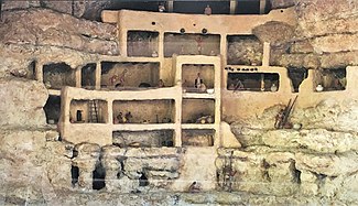
Cliff Palace is the largest cliff dwelling in North America. The structure built by the Ancestral Puebloans is located in Mesa Verde National Park in their former homeland region. The cliff dwelling and park are in Montezuma County, in the southwestern corner of Colorado, in the Southwestern United States.

<span class="mw-page-title-main">Walnut Canyon National Monument</span> Protected area in Coconino County, Arizona

Walnut Canyon National Monument is a United States National Monument located about 10 mi (16 km) southeast of downtown Flagstaff, Arizona, near Interstate 40. The canyon rim elevation is 6,690 ft (2,040 m); the canyon's floor is 350 ft lower. A 0.9 mi (1.4 km) long loop trail descends 185 ft (56 m) into the canyon passing 25 cliff dwelling rooms constructed by the Sinagua, a pre-Columbian cultural group that lived in Walnut Canyon from about 1100 to 1250 AD. Other contemporary habitations of the Sinagua people are preserved in the nearby Tuzigoot and Montezuma Castle national monuments.

<span class="mw-page-title-main">Navajo National Monument</span> National monument in Arizona, United States

Navajo National Monument is a National Monument located within the northwest portion of the Navajo Nation territory in northern Arizona, which was established to preserve three well-preserved cliff dwellings of the Ancestral Puebloan people: Keet Seel, Betatakin, and Inscription House. The monument is high on the Shonto plateau, overlooking the Tsegi Canyon system, west of Kayenta, Arizona. It features a visitor center with a museum, three short self-guided trails, two small campgrounds, and a picnic area.

<span class="mw-page-title-main">Yucca House National Monument</span> Archaeological site in Colorado, United States

Yucca House National Monument is a United States National Monument located in Montezuma County, Colorado between the towns of Towaoc and Cortez, Colorado. Yucca House is a large, unexcavated Ancestral Puebloan archaeological site.

<span class="mw-page-title-main">Sinagua</span> Pre-Columbian culture in Arizona, US

The Sinagua were a pre-Columbian culture that occupied a large area in central Arizona from the Little Colorado River, near Flagstaff, to the Verde River, near Sedona, including the Verde Valley, area around San Francisco Mountain, and significant portions of the Mogollon Rim country, between approximately 500 and 1425 CE.

<span class="mw-page-title-main">Hawkins Preserve</span> Conservation easement in Colorado

Hawkins Preserve is a 122-acre (0.49 km2) property within the city limits of Cortez, Colorado. It is protected by a conservation easement held by the Montezuma Land Conservancy.

<span class="mw-page-title-main">Montezuma Well</span> Natural limestone sinkhole near Rimrock, Arizona

<span class="mw-page-title-main">V Bar V Heritage Site</span> Petroglyph site in central Arizona

The V Bar V Heritage Site is the largest known petroglyph site in the Verde Valley of central Arizona, and one of the best-preserved. The rock art site consists of 1,032 petroglyphs in 13 panels. Acquired by the Coconino National Forest in 1994, the site is protected and kept open to the public by the US Forest Service. Volunteers from the Verde Valley Archaeological Society and the Friends of the Forest provide interpretive tours and on-site management.

The Sierra Ancha Wilderness The Sierra Ancha Wilderness is located about 100 miles east of Phoenix, between Globe and Young. Though fairly small at 32 square miles, it contains some of the most rugged and inaccessible terrain in Arizona. Most of the Sierra Ancha Wilderness lies at an elevation of about 7000 feet. But along the eastern border, is a 20,850 acres (8,440 ha) U.S. wilderness area on the Tonto National Forest in the state of Arizona. The terrain varies from box canyons to high cliffs and pine-covered mountains. Elevations range from lows of about 4,000 feet (1,200 m) to a high of 7,733 feet (2,357 m) at Aztec Peak. It is one of two wilderness areas within the Sierra Ancha mountain range.

<span class="mw-page-title-main">Trail of the Ancients</span> National Scenic Byways in Arizona, Colorado, New Mexico, and Utah, United States

The Trail of the Ancients is a collection of National Scenic Byways located in the U.S. Four Corners states of Utah, Colorado, New Mexico, and Arizona. These byways comprise:

<span class="mw-page-title-main">Honanki</span> Cliff dwelling in Yavapai County, Arizona

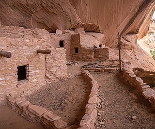
The Honanki Heritage Site is a cliff dwelling and rock art site located in the Coconino National Forest, about 15 miles (24 km) west of Sedona, Arizona. The Sinagua people of the Ancestral Puebloans, and ancestors of the Hopi people, lived here from about 1100 to 1300 CE. The Palatki Heritage Site is nearby, also in the Coconino National Forest.

<span class="mw-page-title-main">Tuzigoot National Monument</span> Historic site in Yavapai County, Arizona, US

Tuzigoot National Monument preserves a 2- to 3-story pueblo ruin on the summit of a limestone and sandstone ridge just east of Clarkdale, Arizona, 120 feet (37 m) above the Verde River floodplain. The Tuzigoot Site is an elongated complex of stone masonry rooms that were built along the spine of a natural outcrop in the Verde Valley. The central rooms stand higher than the others and they appear to have served public functions. The pueblo has 110 rooms. The National Park Service currently administers 58 acres, within an authorized boundary of 834 acres.

<span class="mw-page-title-main">Canyons of the Ancients Visitor Center and Museum</span> Archaeological museum in Dolores, Colorado

The Canyons of the Ancients Visitor Center and Museum located in Dolores, Colorado, is an archaeological museum of Native American pueblo and hunter-gatherer cultures. Two 12th-century archaeological sites, the Escalante and Dominguez Pueblos, at the center were once home to Ancient Pueblo peoples. The museum's permanent and special exhibits display some of the 3 million mostly Ancestral Puebloan artifacts curated at the facility. The center also houses a public research library, educational resources and a museum shop. Wheelchair-accessible facilities include a picnic area and an interpreted nature and cultural trail.

<span class="mw-page-title-main">Pueblo III Period</span> Era in the history of the Pueblo peoples

The Pueblo III Period was the third period, also called the "Great Pueblo period" when Ancestral Puebloans lived in large cliff-dwelling, multi-storied pueblo, or cliff-side talus house communities. By the end of the period, the ancient people of the Four Corners region migrated south into larger, centralized pueblos in central and southern Arizona and New Mexico.

<span class="mw-page-title-main">Basketmaker culture</span> Pre-Ancestral Puebloan period

The Basketmaker culture of the pre-Ancestral Puebloans began about 1500 BC and continued until about AD 750 with the beginning of the Pueblo I Era. The prehistoric American southwestern culture was named "Basketmaker" for the large number of baskets found at archaeological sites of 3,000 to 2,000 years ago.

<span class="mw-page-title-main">Sears-Kay Ruin</span> United States historic place

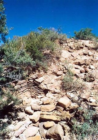
The Sears-Kay Ruin are the remains of what once was a fortification of the Hohokam culture. The ruins are located in the area of the Tonto National Forest just outside of the town of Carefree, Arizona. On November 24, 1995, it was listed in the National Register of Historic Places.

References

Notes

  1. "Listing of acreage – December 31, 2011" (XLSX). Land Resource Division, National Park Service. Retrieved May 14, 2012. (National Park Service Acreage Reports)
  2. "NPS Annual Recreation Visits Report". National Park Service. Retrieved June 15, 2019.
  3. "National Register Information System". National Register of Historic Places . National Park Service. July 9, 2010.
  4. "Montezuma Castle National Monument" . Retrieved March 20, 2011.
  5. 1 2 3 4 5 "A Past Preserved in Stone: A History of Montezuma Castle National Monument" (PDF). Western National Parks Association.
  6. Protas, Josh (2002). Explorations, Impressions, and Excavations: The Prehistoric Ruins of the Verde Valley in the Nineteenth Century. Tucson, Arizona: Western National Parks Association. Retrieved July 17, 2008.
  7. 1 2 3 Reid, J. Jefferson; Whittlesey, Stephanie (1997). The Archaeology of Ancient Arizona. Tucson: University of Arizona Press. pp. 222–23, 225–26. ISBN   978-0816513802. OCLC   941898416.
  8. 1 2 Bucci, Melanie; Petryszyn, Yar; Krausman, Paul R. (2011). "Bat Occurrence and Use of Archaeological Sites at Three National Monuments in Central Arizona". Journal of the Arizona–Nevada Academy of Science. Arizona–Nevada Academy of Sciences. 43 (1): 1–5. doi:10.2181/036.043.0101. JSTOR   41510539. S2CID   85299004.
  9. Kessler, Nicholas; Guebard, Matthew; Hodgins, Gregory; Hoedl, Lucas (2022). "New Tree-Ring-Radiocarbon Dates Reveal Drought-Migration Linage for Central Arizona Cliff Dwellings". Journal of Archaeological Science: Reports. 41: 103289. Bibcode:2022JArSR..41j3289K. doi:10.1016/j.jasrep.2021.103289. S2CID   245285813.
  10. 1 2 "Vascular Plant and Vertebrate Inventory of Montezuma Castle National Monument" (PDF). United States Geological Survey and University of Arizona, School of Natural Resources.
  11. "National Register Information System". National Register of Historic Places . National Park Service. March 13, 2009.
  12. "Montezuma Castle (National Monument)". Travelocity.com. Archived from the original on October 28, 2008.
  13. "NOWData – NOAA Online Weather Data". National Oceanic and Atmospheric Administration. Retrieved December 12, 2022.
  14. "Summary of Monthly Normals 1991–2020". National Oceanic and Atmospheric Administration. Retrieved December 14, 2022.
  15. 1 2 Weber, Cheryl (July 4, 2013). "Rocky Slope Residence". www.architectmagazine.com. Retrieved April 8, 2022.

Bibliography